
Swafield
Encyclopedia
Swafield is a village and a civil parish
in the English
county of Norfolk
. The village is 16.4 miles (26.4 km) north north east of Norwich
, 10.1 miles (16.3 km) south south East of Cromer
and 133 miles (214 km) north-east of London
. The village lies 1.4 miles (2.3 km) north of the town of North Walsham
. The village sits astride the B1145
Kings Lynn to Mundesley
road that dissects North Norfolk
west to east. The nearest railway station is at North Walsham
for the Bittern Line
which runs between Cromer and Norwich. The nearest airport is Norwich International Airport
. The parish had in 2001 census
, a population of 273. For the purposes of local government, the parish falls within the district
of North Norfolk.
of 1085. In the great book Swafield is recorded by the name Suafelda, Suaffelda andSuauelda, the main landholders being Bishop William and William d'Ecouis
with the main tenant being Ranulf brother of Ilger. The survey also mentions a church.
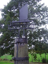
, which is the only canal in Norfolk, was constructed and opened in 1826, and is 8.7 miles long and runs from Swafield Bridge to a junction with the River Ant at Smallburgh. The canal was constructed with locks a little wider than most canals in the UK to accommodate the use of the Norfolk wherries, hence the image of a wherry on Swafield’s village sign.
 The parish church of Saint Nicholas stands in a commanding position on high ground north of the village. the church is built in the perpendicular style
with large windows and dates from the late 15th century although the tower is from the 14th century and the nave
has a thatched roof. Inside the church the base of the chancel
screen can still be seen. the base is painted red green and gold and was decorated by a 15th century artist. Roses and leaves have been carved in the tracery of the panels, on which there are paintings of the eight apostles. The interior of the roof is decorated bosses. Some of them feature Tudor roses, another a lion, but others have faces on them. One face is of Christ, with the five pointed beard. Another face is surrounded by a crown of thorns, in the rope style of the 15th century. A third face is surrounded by sun rays and represents Christ in glory. Displayed on the north wall there is a little crucifix. It was found in separate pieces over several days in March 1937 on the beach at Walcott, after storms had eroded the cliffs there. Each piece was thickly caked with clay. It is believed the crucifix had been buried purposely and may have been hidden at the time of the Reformation by locals, before the Anglican reformers came and stole it from them, although this is only local folklore with no provenance to prove this case.
Civil parish
In England, a civil parish is a territorial designation and, where they are found, the lowest tier of local government below districts and counties...
in the English
England
England is a country that is part of the United Kingdom. It shares land borders with Scotland to the north and Wales to the west; the Irish Sea is to the north west, the Celtic Sea to the south west, with the North Sea to the east and the English Channel to the south separating it from continental...
county of Norfolk
Norfolk
Norfolk is a low-lying county in the East of England. It has borders with Lincolnshire to the west, Cambridgeshire to the west and southwest and Suffolk to the south. Its northern and eastern boundaries are the North Sea coast and to the north-west the county is bordered by The Wash. The county...
. The village is 16.4 miles (26.4 km) north north east of Norwich
Norwich
Norwich is a city in England. It is the regional administrative centre and county town of Norfolk. During the 11th century, Norwich was the largest city in England after London, and one of the most important places in the kingdom...
, 10.1 miles (16.3 km) south south East of Cromer
Cromer
Cromer is a coastal town and civil parish in north Norfolk, England. The local government authority is North Norfolk District Council, whose headquarters is in Holt Road in the town. The town is situated 23 miles north of the county town, Norwich, and is 4 miles east of Sheringham...
and 133 miles (214 km) north-east of London
London
London is the capital city of :England and the :United Kingdom, the largest metropolitan area in the United Kingdom, and the largest urban zone in the European Union by most measures. Located on the River Thames, London has been a major settlement for two millennia, its history going back to its...
. The village lies 1.4 miles (2.3 km) north of the town of North Walsham
North Walsham
North Walsham is a market town and civil parish in Norfolk, England in the North Norfolk district.-Demographics:The civil parish has an area of and in the 2001 census had a population of 11,998. For the purposes of local government, the parish falls within the district of North...
. The village sits astride the B1145
B1145 road
The B1145 runs for about through the county of Norfolk, England, between King’s Lynn and Mundesley. The road is an alternative route to the A47 between Kings Lynn and Norwich by way of the A1067 from Bawdeswell onwards.-History:...
Kings Lynn to Mundesley
Mundesley
Mundesley is a coastal village and a civil parish in the English county of Norfolk. The village is 20.3 miles north-north east of Norwich, 7.3 miles south east of Cromer and 136 miles north east of London. The village lies 5.6 miles north-north east of the town of North Walsham. The nearest...
road that dissects North Norfolk
North Norfolk
North Norfolk is a local government district in Norfolk, United Kingdom. Its council is based in Cromer. The council headquarters can be found approximately out of the town of Cromer on the Holt Road.-History:...
west to east. The nearest railway station is at North Walsham
North Walsham railway station
North Walsham is a railway station in the town of North Walsham in the English county of Norfolk. The station is served by local services operated by National Express East Anglia on the Bittern Line from Norwich to Cromer and Sheringham...
for the Bittern Line
Bittern Line
The Bittern Line is a railway line from Norwich to Cromer then Sheringham in Norfolk, England. It is one of the most scenic in the East of England traversing the Norfolk Broads on its route to the Area of Outstanding Natural Beauty on the North Norfolk Coast. The line is part of the Network Rail...
which runs between Cromer and Norwich. The nearest airport is Norwich International Airport
Norwich International Airport
Norwich International Airport , also known as Norwich Airport, is an airport in the City of Norwich within Norfolk, England north of the city centre and on the edge of the city's suburbs....
. The parish had in 2001 census
United Kingdom Census 2001
A nationwide census, known as Census 2001, was conducted in the United Kingdom on Sunday, 29 April 2001. This was the 20th UK Census and recorded a resident population of 58,789,194....
, a population of 273. For the purposes of local government, the parish falls within the district
Non-metropolitan district
Non-metropolitan districts, or colloquially shire districts, are a type of local government district in England. As created, they are sub-divisions of non-metropolitan counties in a so-called "two-tier" arrangement...
of North Norfolk.
Origins
The name Swafield possibly originates from open land with a track from the Anglo Saxon words swaeth, meaning track, and feld, meaning field, often a forest clearing. The former is the origin of swath or swathe, the latter of field. The name may also mean therefore, open land with swathes, the latter being areas of cut, laying corn.History
Swafield has an entry in the Domesday BookDomesday Book
Domesday Book , now held at The National Archives, Kew, Richmond upon Thames in South West London, is the record of the great survey of much of England and parts of Wales completed in 1086...
of 1085. In the great book Swafield is recorded by the name Suafelda, Suaffelda andSuauelda, the main landholders being Bishop William and William d'Ecouis
William d'Ecouis
William d'Ecouis was a knight who accompanied William the Conqueror on his invasion of England in 1066...
with the main tenant being Ranulf brother of Ilger. The survey also mentions a church.
The North Walsham and Dilham Canal
The North Walsham and Dilham CanalNorth Walsham & Dilham Canal
The North Walsham and Dilham Canal is a waterway in the English county of Norfolk. It is accepted officially that this waterway is the only canal in Norfolk although it is the canalization of the upper reaches of the River Ant. This navigation was constructed with locks a little wider than most...
, which is the only canal in Norfolk, was constructed and opened in 1826, and is 8.7 miles long and runs from Swafield Bridge to a junction with the River Ant at Smallburgh. The canal was constructed with locks a little wider than most canals in the UK to accommodate the use of the Norfolk wherries, hence the image of a wherry on Swafield’s village sign.
The parish church of Saint Nicholas
English Gothic architecture
English Gothic is the name of the architectural style that flourished in England from about 1180 until about 1520.-Introduction:As with the Gothic architecture of other parts of Europe, English Gothic is defined by its pointed arches, vaulted roofs, buttresses, large windows, and spires...
with large windows and dates from the late 15th century although the tower is from the 14th century and the nave
Nave
In Romanesque and Gothic Christian abbey, cathedral basilica and church architecture, the nave is the central approach to the high altar, the main body of the church. "Nave" was probably suggested by the keel shape of its vaulting...
has a thatched roof. Inside the church the base of the chancel
Chancel
In church architecture, the chancel is the space around the altar in the sanctuary at the liturgical east end of a traditional Christian church building...
screen can still be seen. the base is painted red green and gold and was decorated by a 15th century artist. Roses and leaves have been carved in the tracery of the panels, on which there are paintings of the eight apostles. The interior of the roof is decorated bosses. Some of them feature Tudor roses, another a lion, but others have faces on them. One face is of Christ, with the five pointed beard. Another face is surrounded by a crown of thorns, in the rope style of the 15th century. A third face is surrounded by sun rays and represents Christ in glory. Displayed on the north wall there is a little crucifix. It was found in separate pieces over several days in March 1937 on the beach at Walcott, after storms had eroded the cliffs there. Each piece was thickly caked with clay. It is believed the crucifix had been buried purposely and may have been hidden at the time of the Reformation by locals, before the Anglican reformers came and stole it from them, although this is only local folklore with no provenance to prove this case.