
New York State Route 383
Encyclopedia
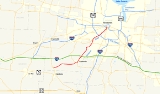
New York State Route 383 (NY 383) is an 18.7 miles (30.09 km) north–south state highway
in Monroe County, New York
, in the United States
. The southern terminus of the route is at an intersection with NY 36
in the hamlet of Mumford
within the town of Wheatland
. Its northern terminus is at a junction with NY 31
in the city of Rochester
. The route follows the Genesee River
and its tributaries for its entire length and passes through the village of Scottsville
.
In the early 20th century, the entirety of modern NY 383 south of Scottsville was part of Route 16, an unsigned legislative route
. In 1921, Route 16 was truncated to end in Caledonia
while the entirety of its former routing north of the village became part of Route 15. The segment of Route 15 between Mumford and Scottsville became part of NY 253
in the 1930 renumbering of state highways in New York. Ca. 1938, this section of NY 253 was replaced by a rerouted NY 35
, a route that extended northeast of Scottsville to Ontario
by way of Rochester. NY 35 was split into two routes in the early 1940s, at which time NY 383 was assigned to the portion between Mumford and Walworth
. NY 383 was truncated to Rochester in the late 1940s, and only minor realignments within the city have occurred since.
in the hamlet of Mumford
, located just north of the border between Monroe
and Livingston
Counties in the town of Wheatland
. Taking on the name Scottsville–Mumford Road, Route 383 follows Oatka Creek
east through open fields and passes through the small hamlet of Garbutt
on its way to the village of Scottsville
, where it becomes Caledonia Avenue. At an intersection with the southern terminus of NY 386
, NY 383 turns east onto Main Street and follows it through the residential southern portion of the village and past the Scottsville Free Library
. Main Street comes to an end at a junction with River Road (NY 251
, which has its western terminus here) and Rochester Street near the northern bank of Oatka Creek. Here, NY 383 curves north onto Rochester Street and proceeds through eastern Scottsville. The street name of NY 383 becomes Scottsville Road upon intersecting the western terminus of NY 253
. Past this junction, the surroundings shift from village streets to housing tracts as the route exits Scottsville. North of the village, NY 383 re-enters open fields once again upon crossing the Wheatland–Chili
.
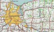
 Within Chili, NY 383 parallels the path of the Genesee River
, which Oatka Creek feeds into east of the village of Scottsville. During this stretch, the route passes under the New York State Thruway
(Interstate 90
or I-90) and intersects Mile Wood Road, a highway connecting NY 383 to Mile of Woods, a hamlet on the west bank of the Genesee River. From this point, NY 383 heads to the north while the river flows to the northwest toward the route. Upon meeting the waterway, NY 383 begins to run along the Genesee River's western bank to a junction with NY 252
. It continues along the riverbank as it proceeds northward, passing over Black Creek and crossing the West Shore Subdivision
, a rail line owned by CSX Transportation
. As NY 383 approaches the Greater Rochester International Airport
, it diverges from the river and has a junction with NY 252A
south of the Airport. NY 383 follows the southern edge of the airport to an interchange with I-390
at exit 17. Shortly afterward, Route 383 crosses the Erie Canal
and enters the city of Rochester
. At this point, maintenance of NY 383 shifts from the New York State Department of Transportation
to the city of Rochester.
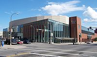
Scottsville Road continues within the city for four blocks to a three-way junction with Genesee Street and Elmwood Avenue. NY 383 veers north onto Genesee Street for six blocks to Brooks Avenue. Here, the route turns east to access South Plymouth Avenue. NY 383 continues north on Plymouth Avenue through densely populated sections of the city to Ford Street. The route curves east to follow Ford for one block to Exchange Boulevard, where it turns back to the north toward downtown Rochester. NY 383 follows Exchange Boulevard along the Genesee River's west bank and under the Troup-Howell Bridge, which carries I-490
over both NY 383 and the river. Past the bridge, the highway enters downtown, where it passes the City of Rochester Public Safety Building and the Blue Cross Arena
before terminating at a junction with East Broad Street (NY 31
).
extending from the village of Cuba
to the city of Rochester
. Between the hamlet of Mumford
and the village of Scottsville
, Route 16 followed Scottsville–Mumford Road. By 1919, Route 15 was extended northeast from Caledonia
to meet Route 16 in Scottsville. Within the village, it was routed on River Road and Main Street. On March 1, 1921, Route 16 was truncated to end in Le Roy
while the portion of its former routing north of Caledonia became part of a realigned and extended Route 15. None of Route 15 between Mumford and Scottsville was assigned a designation when the first set of routes in the modern state highway system were assigned in 1924.
 The portion of former legislative Route 15 from Mumford to Scottsville and the segment of pre-1921 legislative Route 15 on Main Street in Scottsville was designated as the westernmost portion of NY 253
, a highway extending from Mumford to Henrietta
, as part of the 1930 renumbering of state highways in New York. In Scottsville, NY 253 was concurrent with NY 35
, a route stretching from Buffalo
to Ontario
via Canawaugus (west of Avon
), Rochester, and Walworth
, on Rochester Street. Ca. 1938, U.S. Route 20 was rerouted to follow NY 35 between Buffalo and Avon. As a result, NY 35 was reconfigured south of Scottsville to follow the routing of NY 253 to Mumford instead, where it ended at NY 36
. NY 253 was then truncated to the former northern terminus of its overlap with NY 35 northeast of Scottsville. The NY 35 designation was split into two designations in the early 1940s, with the portion from Mumford to Ontario Center Road in Walworth becoming NY 383.
Within Rochester, NY 383 was initially routed on Scottsville Road, Elmwood and Plymouth Avenues, Main Street, and Winton Road. At the junction of Winton and Blossom Roads, NY 383 turned east to follow Blossom into Penfield
. It then veered eastward onto Browncroft Boulevard and followed modern NY 286
east to Walworth. The portion of NY 383 east of Winton Road became NY 286 in the late 1940s. At the same time, NY 383 was truncated to the junction of Plymouth Avenue and Main Street in Rochester. NY 383 was further truncated to an interchange with the newly-constructed Inner Loop
in the mid-1950s.
In the late 1970s, NY 383 was rerouted to follow Ford Street and Exchange Boulevard around the southeastern edge of Rochester's Corn Hill district to a new terminus at Broad Street (NY 31
) in downtown Rochester. The route's former alignment on Plymouth Avenue was split into two segments in the late 1980s as part of a larger reconfiguration of Corn Hill's street layout. In the mid-2000s, NY 383 was rerouted between Elmwood and Brooks Avenues to follow Genesee Street instead. This realignment was made out of necessity as a portion of South Plymouth Avenue immediately south of Brooks Avenue was removed as part of the construction of the Brooks Landing riverside development project. Incidentally, Genesee Street was part of the routing used by NY 35, NY 383's predecessor, during the 1930s and 1940s.
 NY 383B was an alternate route of NY 383 between Rochester
and Penfield
along Browncroft Boulevard. It was renumbered from NY 35B to NY 383B when the portion of NY 35
in the vicinity of Rochester was redesignated as NY 383 in the early 1940s. It was renumbered again to NY 286A in the late 1940s to match the redesignation of NY 383 east of Rochester to NY 286
. Despite the "B" suffix of the route, it is the only suffixed route in NY 383's history—there has never been a "NY 383A".
State highway
State highway, state road or state route can refer to one of three related concepts, two of them related to a state or provincial government in a country that is divided into states or provinces :#A...
in Monroe County, New York
Monroe County, New York
Monroe County is a county located in the U.S. state of New York. As of the 2010 census, the population was 744,344. It is named after James Monroe, fifth President of the United States of America. Its county seat is the city of Rochester....
, in the United States
United States
The United States of America is a federal constitutional republic comprising fifty states and a federal district...
. The southern terminus of the route is at an intersection with NY 36
New York State Route 36
New York State Route 36 is a north–south state highway in the western part of New York in the United States. The highway extends for from the Pennsylvania state line at Troupsburg, Steuben County northward to Ogden, Monroe County, where it ends at an intersection with NY 31...
in the hamlet of Mumford
Mumford, New York
The hamlet of Mumford lies on the west side of the Town of Wheatland, south of Oatka Creek on NY 36 and south of the terminus of NY 383.-History:The story of Mumford has been written by several local historians...
within the town of Wheatland
Wheatland, New York
Wheatland is a town in Monroe County, New York, United States. The population was 4,775 at the 2010 census. The town is home to Genesee Country Village and Museum.The Town of Wheatland is located in the southwest part of the county....
. Its northern terminus is at a junction with NY 31
New York State Route 31
New York State Route 31 is a state highway that extends for across western and central New York in the United States. The western terminus of the route is at an intersection with NY 104 in the city of Niagara Falls. Its eastern terminus is at a traffic circle with NY 26 in Vernon...
in the city of Rochester
Rochester, New York
Rochester is a city in Monroe County, New York, south of Lake Ontario in the United States. Known as The World's Image Centre, it was also once known as The Flour City, and more recently as The Flower City...
. The route follows the Genesee River
Genesee River
The Genesee River is a North American river flowing northward through the Twin Tiers of Pennsylvania and New York. The river provided the original power for the Rochester area's 19th century mills and still provides hydroelectric power for downtown Rochester....
and its tributaries for its entire length and passes through the village of Scottsville
Scottsville, New York
Scottsville is a village in southwestern Monroe County, New York, United States, and is in the northeastern part of the Town of Wheatland. The population was 2,128 at the 2000 census. The village is named after an early settler, Isaac Scott...
.
In the early 20th century, the entirety of modern NY 383 south of Scottsville was part of Route 16, an unsigned legislative route
Legislative route
In United States, a legislative route or legislative highway is a highway defined by laws passed in a state legislature. The numbering of such highways may or may not correspond to the numbers familiar to the public as part of the state, U.S. highway, and Interstate highway systems...
. In 1921, Route 16 was truncated to end in Caledonia
Caledonia (village), New York
Caledonia is a village in Livingston County, New York, USA. The population was 2,327 at the 2000 census. The name refers to Scotland.The Village of Caledonia is located inside the Town of Caledonia and is southwest of Rochester, Monroe County....
while the entirety of its former routing north of the village became part of Route 15. The segment of Route 15 between Mumford and Scottsville became part of NY 253
New York State Route 253
New York State Route 253 is a long east–west state highway in Monroe County, New York, United States. The western terminus of the route is at NY 383 in the village of Scottsville. Its eastern terminus is at NY 65 in the town of Pittsford...
in the 1930 renumbering of state highways in New York. Ca. 1938, this section of NY 253 was replaced by a rerouted NY 35
New York State Route 35 (1927 – early 1940s)
New York State Route 35 was a state highway in the Finger Lakes region of New York, United States. The western terminus of the route was at NY 36 in the hamlet of Mumford within the town of Wheatland. Its eastern terminus was at U.S. Route 104 in the hamlet of Ontario Center within...
, a route that extended northeast of Scottsville to Ontario
Ontario, New York
Ontario is a town in the northwest corner of Wayne County, New York, United States. The population was 9,778 at the 2000 census, and 10,136 at the 2010 census. The town is named after the Great Lake on its northern border.- History :...
by way of Rochester. NY 35 was split into two routes in the early 1940s, at which time NY 383 was assigned to the portion between Mumford and Walworth
Walworth, New York
Walworth is a town in Wayne County, New York, United States. The population was 8,402 at the 2000 census. The name comes from Reuben Walworth, a state official.The Town of Walworth is on the west border of the county and is east of Rochester, NY....
. NY 383 was truncated to Rochester in the late 1940s, and only minor realignments within the city have occurred since.
Route description
NY 383 begins at an intersection with NY 36New York State Route 36
New York State Route 36 is a north–south state highway in the western part of New York in the United States. The highway extends for from the Pennsylvania state line at Troupsburg, Steuben County northward to Ogden, Monroe County, where it ends at an intersection with NY 31...
in the hamlet of Mumford
Mumford, New York
The hamlet of Mumford lies on the west side of the Town of Wheatland, south of Oatka Creek on NY 36 and south of the terminus of NY 383.-History:The story of Mumford has been written by several local historians...
, located just north of the border between Monroe
Monroe County, New York
Monroe County is a county located in the U.S. state of New York. As of the 2010 census, the population was 744,344. It is named after James Monroe, fifth President of the United States of America. Its county seat is the city of Rochester....
and Livingston
Livingston County, New York
As of the census of 2000, there were 64,328 people, 22,150 households, and 15,349 families residing in the county. The population density was 102 people per square mile . There were 24,023 housing units at an average density of 38 per square mile...
Counties in the town of Wheatland
Wheatland, New York
Wheatland is a town in Monroe County, New York, United States. The population was 4,775 at the 2010 census. The town is home to Genesee Country Village and Museum.The Town of Wheatland is located in the southwest part of the county....
. Taking on the name Scottsville–Mumford Road, Route 383 follows Oatka Creek
Oatka Creek
Oatka Creek is the third longest tributary of the Genesee River, located entirely in the Western New York region of the U.S. state of New York. From southern Wyoming County, it flows to the Genesee near Scottsville, draining an area of that includes all or part of 23 towns and villages in...
east through open fields and passes through the small hamlet of Garbutt
Garbutt, New York
Garbutt, New York is a hamlet located between the village of Scottsville and the hamlet of Mumford. It sits at the intersection of Scottsville-Mumford Road and Union Street in the Town of Wheatland in Monroe County...
on its way to the village of Scottsville
Scottsville, New York
Scottsville is a village in southwestern Monroe County, New York, United States, and is in the northeastern part of the Town of Wheatland. The population was 2,128 at the 2000 census. The village is named after an early settler, Isaac Scott...
, where it becomes Caledonia Avenue. At an intersection with the southern terminus of NY 386
New York State Route 386
New York State Route 386 is a north–south state highway located in the western suburbs of the city of Rochester in Monroe County, New York, in the United States. Its southern terminus is at an intersection with NY 383 in the village of Scottsville. The northern end of the highway is...
, NY 383 turns east onto Main Street and follows it through the residential southern portion of the village and past the Scottsville Free Library
Scottsville Free Library
The Scottsville Free Library, located at 28 Main Street in the village of Scottsville, New York, with a small branch at 883 George Street in Mumford, serves the people of the towns of Wheatland and Chili, as well as adjacent areas in Monroe County....
. Main Street comes to an end at a junction with River Road (NY 251
New York State Route 251
New York State Route 251 is an east–west state highway in western New York in the United States. It extends for from NY 383 in Scottsville, Monroe County, to NY 96 in the town of Victor, Ontario County...
, which has its western terminus here) and Rochester Street near the northern bank of Oatka Creek. Here, NY 383 curves north onto Rochester Street and proceeds through eastern Scottsville. The street name of NY 383 becomes Scottsville Road upon intersecting the western terminus of NY 253
New York State Route 253
New York State Route 253 is a long east–west state highway in Monroe County, New York, United States. The western terminus of the route is at NY 383 in the village of Scottsville. Its eastern terminus is at NY 65 in the town of Pittsford...
. Past this junction, the surroundings shift from village streets to housing tracts as the route exits Scottsville. North of the village, NY 383 re-enters open fields once again upon crossing the Wheatland–Chili
Chili, New York
Chili is a town in Monroe County, New York, USA. The population was 28,625 at the 2010 census. It is a suburb of the city of Rochester.The Town of Chili was established in 1822 from part of the Town of Riga....
.
Genesee River
The Genesee River is a North American river flowing northward through the Twin Tiers of Pennsylvania and New York. The river provided the original power for the Rochester area's 19th century mills and still provides hydroelectric power for downtown Rochester....
, which Oatka Creek feeds into east of the village of Scottsville. During this stretch, the route passes under the New York State Thruway
New York State Thruway
The New York State Thruway is a system of limited-access highways located within the state of New York in the United States. The system, known officially as the Governor Thomas E. Dewey Thruway for former New York Governor Thomas E. Dewey, is operated by the New York State Thruway Authority and...
(Interstate 90
Interstate 90 in New York
Interstate 90 is a part of the Interstate Highway System that runs from Seattle, Washington, to Boston, Massachusetts. In the U.S. state of New York, I-90 extends from the Pennsylvania state line at Ripley to the Massachusetts state line at Canaan...
or I-90) and intersects Mile Wood Road, a highway connecting NY 383 to Mile of Woods, a hamlet on the west bank of the Genesee River. From this point, NY 383 heads to the north while the river flows to the northwest toward the route. Upon meeting the waterway, NY 383 begins to run along the Genesee River's western bank to a junction with NY 252
New York State Route 252
New York State Route 252 is an east–west state highway south of Rochester in Monroe County, New York, in the United States. The western terminus of the route is at an intersection with NY 33A in Chili and the eastern terminus is at a junction with NY 64 and NY 96 in the village...
. It continues along the riverbank as it proceeds northward, passing over Black Creek and crossing the West Shore Subdivision
West Shore Subdivision
The West Shore Subdivision is a railroad line owned by CSX Transportation in the U.S. state of New York. The line runs from Fairport, CP-359, west to North Chili, CP-382, along a former New York Central Railroad line. Both of its ends are at the Rochester Subdivision; it provides a southern bypass...
, a rail line owned by CSX Transportation
CSX Transportation
CSX Transportation operates a Class I railroad in the United States known as the CSX Railroad. It is the main subsidiary of the CSX Corporation. The company is headquartered in Jacksonville, Florida, and owns approximately 21,000 route miles...
. As NY 383 approaches the Greater Rochester International Airport
Greater Rochester International Airport
Greater Rochester International Airport is a county-owned public-use airport located three nautical miles southwest of the central business district of Rochester, a city in Monroe County, New York, United States...
, it diverges from the river and has a junction with NY 252A
New York State Route 252A
New York State Route 252A is an east–west state highway located within the town of Chili in Monroe County, New York, in the United States. The western terminus of the route is at an intersection with NY 33A and NY 386 in the hamlet of Chili Center. Its eastern terminus is at a...
south of the Airport. NY 383 follows the southern edge of the airport to an interchange with I-390
Interstate 390
Interstate 390 is a north–south auxiliary Interstate Highway located entirely within New York in the United States. The southern terminus of the route is at the Southern Tier Expressway in the town of Avoca. Its northern terminus is at I-490 in Rochester...
at exit 17. Shortly afterward, Route 383 crosses the Erie Canal
Erie Canal
The Erie Canal is a waterway in New York that runs about from Albany, New York, on the Hudson River to Buffalo, New York, at Lake Erie, completing a navigable water route from the Atlantic Ocean to the Great Lakes. The canal contains 36 locks and encompasses a total elevation differential of...
and enters the city of Rochester
Rochester, New York
Rochester is a city in Monroe County, New York, south of Lake Ontario in the United States. Known as The World's Image Centre, it was also once known as The Flour City, and more recently as The Flower City...
. At this point, maintenance of NY 383 shifts from the New York State Department of Transportation
New York State Department of Transportation
The New York State Department of Transportation is responsible for the development and operation of highways, railroads, mass transit systems, ports, waterways and aviation facilities in the U.S...
to the city of Rochester.
Scottsville Road continues within the city for four blocks to a three-way junction with Genesee Street and Elmwood Avenue. NY 383 veers north onto Genesee Street for six blocks to Brooks Avenue. Here, the route turns east to access South Plymouth Avenue. NY 383 continues north on Plymouth Avenue through densely populated sections of the city to Ford Street. The route curves east to follow Ford for one block to Exchange Boulevard, where it turns back to the north toward downtown Rochester. NY 383 follows Exchange Boulevard along the Genesee River's west bank and under the Troup-Howell Bridge, which carries I-490
Interstate 490 (New York)
Interstate 490 is an auxiliary Interstate Highway that serves the city of Rochester, New York, in the United States. It acts as a northerly alternate route to the New York State Thruway , leaving it at exit 47 in the town of Le Roy and rejoining the highway at exit 45 in the town of...
over both NY 383 and the river. Past the bridge, the highway enters downtown, where it passes the City of Rochester Public Safety Building and the Blue Cross Arena
Blue Cross Arena
The Blue Cross Arena at the War Memorial is a multi-purpose indoor arena, located in Rochester, New York. Its maximum seating capacity is 13,000...
before terminating at a junction with East Broad Street (NY 31
New York State Route 31
New York State Route 31 is a state highway that extends for across western and central New York in the United States. The western terminus of the route is at an intersection with NY 104 in the city of Niagara Falls. Its eastern terminus is at a traffic circle with NY 26 in Vernon...
).
History
In 1908, the New York State Legislature created Route 16, an unsigned legislative routeLegislative route
In United States, a legislative route or legislative highway is a highway defined by laws passed in a state legislature. The numbering of such highways may or may not correspond to the numbers familiar to the public as part of the state, U.S. highway, and Interstate highway systems...
extending from the village of Cuba
Cuba (village), New York
Cuba is a village in Allegany County, New York, United States. The population was 1,633 at the 2000 census.The Village of Cuba is in the western part of the Town of Cuba at the junction of Routes 305 and 446 on Oil Creek.- History :...
to the city of Rochester
Rochester, New York
Rochester is a city in Monroe County, New York, south of Lake Ontario in the United States. Known as The World's Image Centre, it was also once known as The Flour City, and more recently as The Flower City...
. Between the hamlet of Mumford
Mumford, New York
The hamlet of Mumford lies on the west side of the Town of Wheatland, south of Oatka Creek on NY 36 and south of the terminus of NY 383.-History:The story of Mumford has been written by several local historians...
and the village of Scottsville
Scottsville, New York
Scottsville is a village in southwestern Monroe County, New York, United States, and is in the northeastern part of the Town of Wheatland. The population was 2,128 at the 2000 census. The village is named after an early settler, Isaac Scott...
, Route 16 followed Scottsville–Mumford Road. By 1919, Route 15 was extended northeast from Caledonia
Caledonia (village), New York
Caledonia is a village in Livingston County, New York, USA. The population was 2,327 at the 2000 census. The name refers to Scotland.The Village of Caledonia is located inside the Town of Caledonia and is southwest of Rochester, Monroe County....
to meet Route 16 in Scottsville. Within the village, it was routed on River Road and Main Street. On March 1, 1921, Route 16 was truncated to end in Le Roy
Le Roy (village), New York
Le Roy is a village in Genesee County, New York, United States. The population was 4,462 at the 2000 census.The Village of Le Roy lies in the center of the Town of Le Roy at the intersection of Routes 5 and 19.- History :...
while the portion of its former routing north of Caledonia became part of a realigned and extended Route 15. None of Route 15 between Mumford and Scottsville was assigned a designation when the first set of routes in the modern state highway system were assigned in 1924.
New York State Route 253
New York State Route 253 is a long east–west state highway in Monroe County, New York, United States. The western terminus of the route is at NY 383 in the village of Scottsville. Its eastern terminus is at NY 65 in the town of Pittsford...
, a highway extending from Mumford to Henrietta
Henrietta, New York
Henrietta is a town in Monroe County, New York, United States. It is a suburb of Rochester. The population was 42,581 at the 2010 census. Established in 1818, the town is named after Henrietta Laura Pulteney, Countess of Bath, daughter of Sir William Pulteney, 5th Baronet, a major British...
, as part of the 1930 renumbering of state highways in New York. In Scottsville, NY 253 was concurrent with NY 35
New York State Route 35 (1927 – early 1940s)
New York State Route 35 was a state highway in the Finger Lakes region of New York, United States. The western terminus of the route was at NY 36 in the hamlet of Mumford within the town of Wheatland. Its eastern terminus was at U.S. Route 104 in the hamlet of Ontario Center within...
, a route stretching from Buffalo
Buffalo, New York
Buffalo is the second most populous city in the state of New York, after New York City. Located in Western New York on the eastern shores of Lake Erie and at the head of the Niagara River across from Fort Erie, Ontario, Buffalo is the seat of Erie County and the principal city of the...
to Ontario
Ontario, New York
Ontario is a town in the northwest corner of Wayne County, New York, United States. The population was 9,778 at the 2000 census, and 10,136 at the 2010 census. The town is named after the Great Lake on its northern border.- History :...
via Canawaugus (west of Avon
Avon (village), New York
Avon is a village in Livingston County, New York, USA. The population was 2,977 at the 2000 census. The village is named after the River Avon. ....
), Rochester, and Walworth
Walworth, New York
Walworth is a town in Wayne County, New York, United States. The population was 8,402 at the 2000 census. The name comes from Reuben Walworth, a state official.The Town of Walworth is on the west border of the county and is east of Rochester, NY....
, on Rochester Street. Ca. 1938, U.S. Route 20 was rerouted to follow NY 35 between Buffalo and Avon. As a result, NY 35 was reconfigured south of Scottsville to follow the routing of NY 253 to Mumford instead, where it ended at NY 36
New York State Route 36
New York State Route 36 is a north–south state highway in the western part of New York in the United States. The highway extends for from the Pennsylvania state line at Troupsburg, Steuben County northward to Ogden, Monroe County, where it ends at an intersection with NY 31...
. NY 253 was then truncated to the former northern terminus of its overlap with NY 35 northeast of Scottsville. The NY 35 designation was split into two designations in the early 1940s, with the portion from Mumford to Ontario Center Road in Walworth becoming NY 383.
Within Rochester, NY 383 was initially routed on Scottsville Road, Elmwood and Plymouth Avenues, Main Street, and Winton Road. At the junction of Winton and Blossom Roads, NY 383 turned east to follow Blossom into Penfield
Penfield, New York
Penfield is a town in Monroe County, New York, United States. The population was 36,242 at the 2010 census.The town was incorporated in 1810 by the proprietor, Daniel Penfield, who purchased the town lands in 1795 and moved to the area in 1809. Penfield is a suburb of Rochester, New York...
. It then veered eastward onto Browncroft Boulevard and followed modern NY 286
New York State Route 286
New York State Route 286 is an east–west state highway in the vicinity of the city of Rochester in New York, United States. It links Rochester to its eastern suburbs and to western Wayne County. The western terminus of the route is at exit 7 on NY 590 just inside the Rochester city...
east to Walworth. The portion of NY 383 east of Winton Road became NY 286 in the late 1940s. At the same time, NY 383 was truncated to the junction of Plymouth Avenue and Main Street in Rochester. NY 383 was further truncated to an interchange with the newly-constructed Inner Loop
Inner Loop (Rochester)
The Inner Loop is an expressway that encloses downtown Rochester, New York, in the United States. Although the expressway is a continuous loop, only the portion of the loop north of Interstate 490 is signed as the "Inner Loop"...
in the mid-1950s.
In the late 1970s, NY 383 was rerouted to follow Ford Street and Exchange Boulevard around the southeastern edge of Rochester's Corn Hill district to a new terminus at Broad Street (NY 31
New York State Route 31
New York State Route 31 is a state highway that extends for across western and central New York in the United States. The western terminus of the route is at an intersection with NY 104 in the city of Niagara Falls. Its eastern terminus is at a traffic circle with NY 26 in Vernon...
) in downtown Rochester. The route's former alignment on Plymouth Avenue was split into two segments in the late 1980s as part of a larger reconfiguration of Corn Hill's street layout. In the mid-2000s, NY 383 was rerouted between Elmwood and Brooks Avenues to follow Genesee Street instead. This realignment was made out of necessity as a portion of South Plymouth Avenue immediately south of Brooks Avenue was removed as part of the construction of the Brooks Landing riverside development project. Incidentally, Genesee Street was part of the routing used by NY 35, NY 383's predecessor, during the 1930s and 1940s.
NY 383B
Rochester, New York
Rochester is a city in Monroe County, New York, south of Lake Ontario in the United States. Known as The World's Image Centre, it was also once known as The Flour City, and more recently as The Flower City...
and Penfield
Penfield, New York
Penfield is a town in Monroe County, New York, United States. The population was 36,242 at the 2010 census.The town was incorporated in 1810 by the proprietor, Daniel Penfield, who purchased the town lands in 1795 and moved to the area in 1809. Penfield is a suburb of Rochester, New York...
along Browncroft Boulevard. It was renumbered from NY 35B to NY 383B when the portion of NY 35
New York State Route 35 (1927 – early 1940s)
New York State Route 35 was a state highway in the Finger Lakes region of New York, United States. The western terminus of the route was at NY 36 in the hamlet of Mumford within the town of Wheatland. Its eastern terminus was at U.S. Route 104 in the hamlet of Ontario Center within...
in the vicinity of Rochester was redesignated as NY 383 in the early 1940s. It was renumbered again to NY 286A in the late 1940s to match the redesignation of NY 383 east of Rochester to NY 286
New York State Route 286
New York State Route 286 is an east–west state highway in the vicinity of the city of Rochester in New York, United States. It links Rochester to its eastern suburbs and to western Wayne County. The western terminus of the route is at exit 7 on NY 590 just inside the Rochester city...
. Despite the "B" suffix of the route, it is the only suffixed route in NY 383's history—there has never been a "NY 383A".