
Interstate 390
Encyclopedia
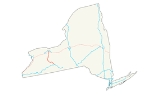
Interstate 390 is a 75.86 miles (122.08 km) north–south auxiliary Interstate Highway located entirely within New York
in the United States. The southern terminus of the route is at the Southern Tier Expressway (I-86
and New York State Route 17 or NY 17) in the town of Avoca
. Its northern terminus is at I-490
(the Western Expressway) in Rochester
. North of I-490, the expressway continues as NY 390
to the Lake Ontario State Parkway
in Greece
. I-390 connects to its parent, I-90
(the New York State Thruway
), in Henrietta
, a southern suburb of Rochester. The route is known as the Genesee Expressway from Avoca to I-590
in Brighton
, where it becomes part of the Rochester Outer Loop.
In addition to servicing Rochester, I-390 serves as an important connecting route between the Rochester metropolitan area and Corning
and the rest of the Southern Tier
of New York. The freeway also serves several smaller communities between Corning and Rochester, including the Livingston County
villages of Dansville
and Geneseo. I-390 effectively replaced U.S. Route 15
(US 15) and parallels NY 15
, US 15's de facto successor north of Corning. From Lakeville north to Brighton
, the two routes cross paths four times and are located no more than 1.5 miles (2.4 km) apart along the entire stretch.
The first section of the Genesee Expressway opened in the late 1960s, extending from Wayland
in the east to Dansville in the west. The entirety of the then-proposed highway was designated as New York State Route 401 in 1970 but redesignated as I-390 ca. 1973. More sections of the freeway opened throughout the 1970s, and I-390 was extended northwestward to cover the southwestern quadrant of the Rochester Outer Loop in 1980 following the elimination of NY 47
. I-390 was completed in the early 1980s.
and NY 17
proceeds below the overpass carrying those two routes to the west, at an interchange just east of the village of Avoca
in Steuben County
. The expressway heads northwest through the narrow valley of the Cohocton River
to Cohocton
, where the river leaves the expressway and heads north toward the hamlet of Atlanta. I-390 climbs gradually as it continues past Cohocton, eventually turning due west as it descends to an interchange with NY 21
south of Wayland
. This exit is also the southern terminus of NY 15
, which eventually parallels the interstate further north.
The road climbs again as it makes a gentle bend and widens as it crosses the Livingston County
line just south of Dansville
and north of Stony Brook State Park
. Descending again, it returns to its northwestern heading. North of the village it climbs to the west side of the wide valley of Canaseraga Creek, giving the roadway a view over the area known locally as the Flats. NY 36
begins to parallel the highway closely, with NY 63
on the far side of the Flats. Just south of the hamlet of Sonyea, NY 36 crosses at a diamond interchange. I-390 turns northeast briefly but resumes its northwest course soon afterward. At this point, the highway follows more level ground, with woods and swamps mostly replacing farmland in the surrounding landscape.
After passing rest areas on either side, I-390 reaches the NY 408
exit adjacent to the American Rock Salt mine at Hampton Corners. Here, most traffic bound for the Buffalo
area exits to go west to Mount Morris
, visible across the flats from the freeway, where it follows NY 36 north. To the immediate east of the exit Route 408 ends at Route 63, which carries traffic from the interstate into Geneseo, the county seat
. A mile north of the exit, Canaseraga Creek drains into the Genesee River
on the road's west side.
The expressway continues north through Livingston County to Geneseo, which I-390 skirts to the south and east. While there is no exit for Geneseo on the part of the freeway that encroaches the village, exit 8, an interchange with US 20A
east of Geneseo, provides the connection. Also accessible from the junction is the hamlet of Lakeville, situated off to the east at the junction of US 20A and NY 15. I-390 continues on, encountering NY 15 north of Lakeville and southeast of Avon
. From here north to Rochester
, I-390 and NY 15 follow closely parallel alignments. Both highways meet US 20
and NY 5
east of Avon prior to crossing into Monroe County
.
in Rush
ahead of an interchange with both the New York State Thruway
(I-90) and NY 253
in southern Henrietta
. Past the Thruway, the transition from the rural landscapes of the Southern Tier and Finger Lakes
to residential and commercial areas is completed as I-390 continues into the suburbs of Rochester and the commercial center of Henrietta. Roughly 1.5 miles (2.4 km) from NY 253, I-390 has an exit leading to Hylan Drive, a through street leading to The Marketplace Mall
. Farther north, I-390 meets both NY 15A
and NY 252
in equally commercialized areas before entering Brighton
.
 Shortly after entering Brighton, I-390 crosses over the Erie Canal
and meets the southern terminus of I-590
at a large semi-directional T interchange located adjacent to the canal and South Clinton Avenue. The latter of the two passes through the eastern half of the junction, crossing over I-590 but passing under the ramps connecting I-590 south to I-390 south and I-390 north to I-590 north. Past the exit, I-390 turns to the west, joining the Rochester Outer Loop and crossing back over the canal ahead of an interchange with NY 15 and NY 15A. After passing under NY 15, the freeway begins to run along the southern edge of the Erie Canal, here delimiting the southern city limits of Rochester. The canal and I-390 run side-by-side for just over 1 miles (1.6 km) to the Genesee River, where I-390 veers slightly to the west as it meets NY 383
at a partial cloverleaf interchange.
For the next mile (1.6 km), I-390 follows a more northwesterly alignment along the northeastern edge of the Greater Rochester International Airport
grounds. It meets Brooks Avenue (NY 204
) at the northern edge of the grounds before leaving the airport area and curving more to the north, matching changes in the Erie Canal's alignment as both entities proceed around the southwestern edge of the city. Now in Gates
, I-390 crosses over the Rochester and Southern Railroad
just south of another partial cloverleaf interchange with NY 33A
. The freeway continues on, passing under the CSX Transportation
-owned Rochester Subdivision
and NY 33
before connecting to I-490
at a complex interchange roughly 0.25 mile (0.402335 km) west of the canal and the city limits. I-390 ends here; however, the freeway continues northward toward Greece
as NY 390
.
and Dansville
began ca. 1966. The highway opened to traffic ca. 1968 as a realignment of NY 245
. On January 1, 1970, the expressway became part of NY 401, a designation that also extended south to the town of Avoca
and north to the city of Rochester
along the Genesee Expressway, a proposed freeway utilizing the US 15
corridor. NY 401 was added to the Interstate Highway System
and redesignated I-390 ca. 1973. As initially planned, I-390 would continue north into downtown Rochester and end at I-490
while the entirety of the Rochester Outer Loop south of I-490 would become I-590
.
Construction began ca. 1974 on the portion of I-390 between NY 17
near the village of Avoca
and NY 21
south of Wayland. It opened to traffic ca. 1976. By 1977, work had begun on the leg between NY 251
in Rush
and the New York State Thruway
(I-90) in Henrietta
. This section was completed by 1981, as were the Dansville–Groveland
(NY 36
), Avon
–Rush, and Thruway – Hylan Drive segments. The remainder of I-390 in Monroe County
up to the modern I-390 / I-590 interchange was built ca. 1981, and the final gap in the expressway from NY 36 to US 20 in Livingston County
opened ca. 1982.
By the late 1970s, the proposed extension of I-390 into downtown Rochester was scrapped. Instead, the state of New York began to look into the possibility of changing the designations that were assigned to the Outer Loop. In one proposal submitted to the American Association of State Highway and Transportation Officials
in the late 1970s, I-590 would be truncated to begin at the then-proposed junction with I-390 in Brighton
. The rest of the loop south of I-490, meanwhile, would become part of an extended I-390, which would continue north past I-490 to the Outer Loop's northwestern end at the Lake Ontario State Parkway
. NY 47
, the then-current designation for much of the Outer Loop, would be eliminated entirely.
Most of the plans went into effect when the NY 47 designation was eliminated on March 18, 1980. The southern half of the Outer Loop was signed as planned; however, I-390 and I-590 were modified to end at their junctions with I-490. While NY 47 was officially assigned to the entirety of the Outer Loop prior to its removal, only the portion from NY 383
north to I-490 was actually once part of NY 47.
On February 10, 2008, whiteout conditions caused a 36-car pileup near the Scottsville Road exit, which led to a 17-year-old girl's death. Firefighters had to climb over cars and cut off roofs to get to people. More than 20 people were taken to the hospital.
On July 17, 2011, a tour bus heading northbound from Washington, D.C.
to Niagara Falls crashed between the Avoca and Cohocton exits, killing two and injuring at least 35 others. The cause of the crash remains under investigation.
|rowspan=4|Steuben
|rowspan=3|Avoca
|0.00
|
|
|Southbound exit and northbound entrance
|-
|2.04
|1
|
|
|-
|11.12
|2
|
|
|-
|Wayland
|16.75
|3
|
|
|-
|rowspan=7|Livingston
|rowspan=2|Dansville
|22.84
|4
|
|
|-
|24.19
|5
|
|
|-
|Groveland
|32.96
|6
|
|
|-
|Mount Morris
|38.77
|7
|
|
|-
|Geneseo
|48.05
|8
|
|
|-
|rowspan=2|Avon
|51.50
|9
|
|
|-
|54.59
|10
|
|
|-
|rowspan=16|Monroe
|Rush
|61.94
|11
|
|
|-
|rowspan=6|Henrietta
|rowspan=2|65.86
|12B
|
|rowspan=2|Single exit 12 northbound
|-
|12A
|
|-
|67.28
|13
|Hylan Drive – Mall
|
|-
|rowspan=2|68.37
|14A
|
|rowspan=2|Single exit 14 northbound; access to NY 252 from I-390 north via NY 15A; NY 252 serves Rochester Institute of Technology
|-
|14B
|
|-
|rowspan=2|
|rowspan=2|15B
|rowspan=2|Brighton–Henrietta Townline Road
|rowspan=2|Southbound exit only; serves Monroe Community College
|-
|rowspan=4|Brighton
|-
|70.29
|15
|
|Signed as exit 15A southbound; southern terminus of I-590
|-
|rowspan=2|71.69
|16B
|
|rowspan=2|Single exit 16 northbound; southbound access to NY 15 via East River Road
|-
|16A
|
|-
|rowspan=2|Rochester
|73.09
|17
|
|Serves Rochester Institute of Technology and University of Rochester
|-
|73.80
|18A-B
|
|
|-
|rowspan=3|Gates
|74.51
|19
|
|
|-
|rowspan=2|75.86
|20A-B
|
|
|-
|
|
|Continuation beyond I-490
New York
New York is a state in the Northeastern region of the United States. It is the nation's third most populous state. New York is bordered by New Jersey and Pennsylvania to the south, and by Connecticut, Massachusetts and Vermont to the east...
in the United States. The southern terminus of the route is at the Southern Tier Expressway (I-86
Interstate 86 (east)
Interstate 86 is an Interstate Highway that extends for through northwestern Pennsylvania and southern New York in the United States...
and New York State Route 17 or NY 17) in the town of Avoca
Avoca (town), New York
Avoca is a town in Steuben County, New York, USA. The population was 2,314 at the 2000 census.The Town of Avoca has a village named Avoca. The town is in the north part of the county, northwest of Bath, New York.- History :...
. Its northern terminus is at I-490
Interstate 490 (New York)
Interstate 490 is an auxiliary Interstate Highway that serves the city of Rochester, New York, in the United States. It acts as a northerly alternate route to the New York State Thruway , leaving it at exit 47 in the town of Le Roy and rejoining the highway at exit 45 in the town of...
(the Western Expressway) in Rochester
Rochester, New York
Rochester is a city in Monroe County, New York, south of Lake Ontario in the United States. Known as The World's Image Centre, it was also once known as The Flour City, and more recently as The Flower City...
. North of I-490, the expressway continues as NY 390
New York State Route 390
New York State Route 390 is a north–south state highway located along the western edge of the city of Rochester, New York, in the United States. The route, a limited-access northward continuation of Interstate 390 , extends for from I-490 in Gates to the Lake Ontario State Parkway in...
to the Lake Ontario State Parkway
Lake Ontario State Parkway
The Lake Ontario State Parkway is a parkway along the southern shore of Lake Ontario in western New York in the United States. The western end of the highway is at a partial interchange within Lakeside Beach State Park in Carlton, Orleans County. Its eastern terminus is at an intersection with...
in Greece
Greece (town), New York
Greece is a town in Monroe County, New York, United States. As of the 2010 United States census, the town had a total population of 96,095. The town motto is "Discover the Promise."...
. I-390 connects to its parent, I-90
Interstate 90 in New York
Interstate 90 is a part of the Interstate Highway System that runs from Seattle, Washington, to Boston, Massachusetts. In the U.S. state of New York, I-90 extends from the Pennsylvania state line at Ripley to the Massachusetts state line at Canaan...
(the New York State Thruway
New York State Thruway
The New York State Thruway is a system of limited-access highways located within the state of New York in the United States. The system, known officially as the Governor Thomas E. Dewey Thruway for former New York Governor Thomas E. Dewey, is operated by the New York State Thruway Authority and...
), in Henrietta
Henrietta, New York
Henrietta is a town in Monroe County, New York, United States. It is a suburb of Rochester. The population was 42,581 at the 2010 census. Established in 1818, the town is named after Henrietta Laura Pulteney, Countess of Bath, daughter of Sir William Pulteney, 5th Baronet, a major British...
, a southern suburb of Rochester. The route is known as the Genesee Expressway from Avoca to I-590
Interstate 590
Interstate 590 is a north–south auxiliary Interstate Highway that serves the immediate southeastern suburbs of the city of Rochester, New York, in the United States. It extends for from an interchange with I-390 in Brighton to the Can of Worms, a complex interchange connecting I-590 to I-490...
in Brighton
Brighton, Monroe County, New York
Brighton is a town in Monroe County, New York, USA. The population was 36,609 at the 2010 census.-History:The Town of Brighton, located on the southeast border of the city of Rochester, was originally settled approximately 1790, and formally established in 1814—earning it recognition as one...
, where it becomes part of the Rochester Outer Loop.
In addition to servicing Rochester, I-390 serves as an important connecting route between the Rochester metropolitan area and Corning
Corning (city), New York
Corning is a city in Steuben County, New York, United States, on the Chemung River. The population was 10,842 at the 2000 census. It is named for Erastus Corning, an Albany financier and railroad executive who was an investor in the company that developed the community.- Overview :The city of...
and the rest of the Southern Tier
Southern Tier
The Southern Tier is a geographical term that refers to the counties of New York State west of the Catskill Mountains along the northern border of Pennsylvania. It is a loosely defined term that generally includes the counties that border Pennsylvania west of Delaware County inclusive...
of New York. The freeway also serves several smaller communities between Corning and Rochester, including the Livingston County
Livingston County, New York
As of the census of 2000, there were 64,328 people, 22,150 households, and 15,349 families residing in the county. The population density was 102 people per square mile . There were 24,023 housing units at an average density of 38 per square mile...
villages of Dansville
Dansville, Livingston County, New York
Dansville is a village in the town of North Dansville in the eastern part of Livingston County, New York, United States. As of the census, the village population was 4,832. The village is named after Daniel Faulkner, an early settler. Interstate 390 passes next to the west side of the village.-...
and Geneseo. I-390 effectively replaced U.S. Route 15
U.S. Route 15 in New York
U.S. Route 15 is a part of the U.S. Highway System that runs from Walterboro, South Carolina, to Painted Post, New York. In the U.S. state of New York, US 15 extends through the Southern Tier from the Pennsylvania state line at Lindley north to an interchange with the Southern Tier...
(US 15) and parallels NY 15
New York State Route 15
New York State Route 15 is a north–south state highway located in western New York in the United States. The southern terminus of the route is officially at Interstate 390 exit 3 south of the village of Wayland, although some signage indicating that NY 15 continues south to...
, US 15's de facto successor north of Corning. From Lakeville north to Brighton
Brighton, Monroe County, New York
Brighton is a town in Monroe County, New York, USA. The population was 36,609 at the 2010 census.-History:The Town of Brighton, located on the southeast border of the city of Rochester, was originally settled approximately 1790, and formally established in 1814—earning it recognition as one...
, the two routes cross paths four times and are located no more than 1.5 miles (2.4 km) apart along the entire stretch.
The first section of the Genesee Expressway opened in the late 1960s, extending from Wayland
Wayland (village), New York
Wayland is a village in Steuben County, New York, United States. The population was 1,893 at the 2000 census.The Village of Wayland is in north part of the Town of Wayland, near the north border of Steuben County.- History :...
in the east to Dansville in the west. The entirety of the then-proposed highway was designated as New York State Route 401 in 1970 but redesignated as I-390 ca. 1973. More sections of the freeway opened throughout the 1970s, and I-390 was extended northwestward to cover the southwestern quadrant of the Rochester Outer Loop in 1980 following the elimination of NY 47
New York State Route 47
New York State Route 47 was a long state highway around Rochester in New York, United States. It formed a semicircle through the inner suburbs of Rochester, following expressways west and east of the city and surface streets south of Rochester. The western terminus of the route was at an...
. I-390 was completed in the early 1980s.
Route description
In its southern sections, which account for most of the highway's mileage, I-390 is a lightly trafficked freeway of two lanes in either direction going through minimally populated rural areas. Closer to Rochester, it becomes wider to accommodate the increased traffic it handles in the city itself.Steuben and Livingston Counties
I-390 begins as westbound traffic on the concurrent routes of I-86Interstate 86 (east)
Interstate 86 is an Interstate Highway that extends for through northwestern Pennsylvania and southern New York in the United States...
and NY 17
New York State Route 17
New York State Route 17 is a state highway that extends for through the Southern Tier and Downstate regions of New York in the United States...
proceeds below the overpass carrying those two routes to the west, at an interchange just east of the village of Avoca
Avoca (village), New York
Avoca is a village located in the Town of Avoca in Steuben County, New York, United States. The population was 1,008 at the 2000 census.The Village of Avoca is located in the eastern part of the town, northwest of Bath, New York.- History :...
in Steuben County
Steuben County, New York
Steuben County is a county located in the U.S. state of New York. As of the 2010 census, the population was 98,990. Its name is in honor of Baron von Steuben, a German general who fought on the American side in the American Revolutionary War, though it is not pronounced the same...
. The expressway heads northwest through the narrow valley of the Cohocton River
Cohocton River
The Cohocton River is a tributary of the Chemung River in western New York in the United States. Via the Chemung River, it is part of the Susquehanna River watershed, flowing to Chesapeake Bay...
to Cohocton
Cohocton (village), New York
Cohocton is a village in Steuben County, New York, United States. The population was 854 at the 2000 census. The name is derived from an Iroquois phrase for "log in the water."...
, where the river leaves the expressway and heads north toward the hamlet of Atlanta. I-390 climbs gradually as it continues past Cohocton, eventually turning due west as it descends to an interchange with NY 21
New York State Route 21
New York State Route 21 is a state highway extending for through the western part of New York in the United States. The southern terminus of the route is at NY 417 in Andover. The northern terminus is at NY 104 in Williamson...
south of Wayland
Wayland (village), New York
Wayland is a village in Steuben County, New York, United States. The population was 1,893 at the 2000 census.The Village of Wayland is in north part of the Town of Wayland, near the north border of Steuben County.- History :...
. This exit is also the southern terminus of NY 15
New York State Route 15
New York State Route 15 is a north–south state highway located in western New York in the United States. The southern terminus of the route is officially at Interstate 390 exit 3 south of the village of Wayland, although some signage indicating that NY 15 continues south to...
, which eventually parallels the interstate further north.
The road climbs again as it makes a gentle bend and widens as it crosses the Livingston County
Livingston County, New York
As of the census of 2000, there were 64,328 people, 22,150 households, and 15,349 families residing in the county. The population density was 102 people per square mile . There were 24,023 housing units at an average density of 38 per square mile...
line just south of Dansville
Dansville, Livingston County, New York
Dansville is a village in the town of North Dansville in the eastern part of Livingston County, New York, United States. As of the census, the village population was 4,832. The village is named after Daniel Faulkner, an early settler. Interstate 390 passes next to the west side of the village.-...
and north of Stony Brook State Park
Stony Brook State Park
Stony Brook State Park is a state park located in Dansville in Livingston County, New York. The park is south of Dansville on New York State Route 36. Route 36 also connects the park to Stony Brook State Park Beach a short distance away....
. Descending again, it returns to its northwestern heading. North of the village it climbs to the west side of the wide valley of Canaseraga Creek, giving the roadway a view over the area known locally as the Flats. NY 36
New York State Route 36
New York State Route 36 is a north–south state highway in the western part of New York in the United States. The highway extends for from the Pennsylvania state line at Troupsburg, Steuben County northward to Ogden, Monroe County, where it ends at an intersection with NY 31...
begins to parallel the highway closely, with NY 63
New York State Route 63
New York State Route 63 is a state highway in the western part of New York in the United States. The southern terminus of the route is at an intersection with NY 15 and NY 21 in the village of Wayland in Steuben County. Its northern end is at a junction with NY 18 in the town...
on the far side of the Flats. Just south of the hamlet of Sonyea, NY 36 crosses at a diamond interchange. I-390 turns northeast briefly but resumes its northwest course soon afterward. At this point, the highway follows more level ground, with woods and swamps mostly replacing farmland in the surrounding landscape.
After passing rest areas on either side, I-390 reaches the NY 408
New York State Route 408
New York State Route 408 is a state highway located entirely within Livingston County, New York, in the United States. It runs north–south from an intersection with NY 70 near the hamlet of Dalton in the town of Nunda to a junction with NY 63 in the town of Groveland near...
exit adjacent to the American Rock Salt mine at Hampton Corners. Here, most traffic bound for the Buffalo
Buffalo, New York
Buffalo is the second most populous city in the state of New York, after New York City. Located in Western New York on the eastern shores of Lake Erie and at the head of the Niagara River across from Fort Erie, Ontario, Buffalo is the seat of Erie County and the principal city of the...
area exits to go west to Mount Morris
Mount Morris (village), New York
Mount Morris is a village located in the Town of Mount Morris in Livingston County, New York, USA. The population was 3,266 at the 2000 census. The village and town are named after Robert Morris....
, visible across the flats from the freeway, where it follows NY 36 north. To the immediate east of the exit Route 408 ends at Route 63, which carries traffic from the interstate into Geneseo, the county seat
County seat
A county seat is an administrative center, or seat of government, for a county or civil parish. The term is primarily used in the United States....
. A mile north of the exit, Canaseraga Creek drains into the Genesee River
Genesee River
The Genesee River is a North American river flowing northward through the Twin Tiers of Pennsylvania and New York. The river provided the original power for the Rochester area's 19th century mills and still provides hydroelectric power for downtown Rochester....
on the road's west side.
The expressway continues north through Livingston County to Geneseo, which I-390 skirts to the south and east. While there is no exit for Geneseo on the part of the freeway that encroaches the village, exit 8, an interchange with US 20A
U.S. Route 20A (New York)
U.S. Route 20A is an east–west alternate route of US 20 that extends for across the western portion of New York in the United States. It leaves US 20 in Hamburg, a suburb of Buffalo, and rejoins it in East Bloomfield about five miles west of Canandaigua, the county seat of...
east of Geneseo, provides the connection. Also accessible from the junction is the hamlet of Lakeville, situated off to the east at the junction of US 20A and NY 15. I-390 continues on, encountering NY 15 north of Lakeville and southeast of Avon
Avon (village), New York
Avon is a village in Livingston County, New York, USA. The population was 2,977 at the 2000 census. The village is named after the River Avon. ....
. From here north to Rochester
Rochester, New York
Rochester is a city in Monroe County, New York, south of Lake Ontario in the United States. Known as The World's Image Centre, it was also once known as The Flour City, and more recently as The Flower City...
, I-390 and NY 15 follow closely parallel alignments. Both highways meet US 20
U.S. Route 20 in New York
U.S. Route 20 is a part of the U.S. Highway System that runs from Newport, Oregon, to Boston, Massachusetts. In the U.S. state of New York, US 20 extends from the Pennsylvania state line at Ripley to the Massachusetts state line in the Berkshire Mountains. US 20 is the longest...
and NY 5
New York State Route 5
New York State Route 5 is a state highway that extends for across the state of New York in the United States. It begins at the Pennsylvania state line in the Chautauqua County town of Ripley and passes through Buffalo, Syracuse, Utica, Schenectady, and several other smaller cities and...
east of Avon prior to crossing into Monroe County
Monroe County, New York
Monroe County is a county located in the U.S. state of New York. As of the 2010 census, the population was 744,344. It is named after James Monroe, fifth President of the United States of America. Its county seat is the city of Rochester....
.
Monroe County
As I-390 heads north through the southern extents of the county, the surroundings become more residential and commercial in nature. The freeway meets NY 15 and NY 251New York State Route 251
New York State Route 251 is an east–west state highway in western New York in the United States. It extends for from NY 383 in Scottsville, Monroe County, to NY 96 in the town of Victor, Ontario County...
in Rush
Rush, New York
Rush is a town in Monroe County, New York, United States. The population was 3,478 at the 2010 census.The Town of Rush is a suburb of Rochester located in the southwest part of the county.-Geography:...
ahead of an interchange with both the New York State Thruway
New York State Thruway
The New York State Thruway is a system of limited-access highways located within the state of New York in the United States. The system, known officially as the Governor Thomas E. Dewey Thruway for former New York Governor Thomas E. Dewey, is operated by the New York State Thruway Authority and...
(I-90) and NY 253
New York State Route 253
New York State Route 253 is a long east–west state highway in Monroe County, New York, United States. The western terminus of the route is at NY 383 in the village of Scottsville. Its eastern terminus is at NY 65 in the town of Pittsford...
in southern Henrietta
Henrietta, New York
Henrietta is a town in Monroe County, New York, United States. It is a suburb of Rochester. The population was 42,581 at the 2010 census. Established in 1818, the town is named after Henrietta Laura Pulteney, Countess of Bath, daughter of Sir William Pulteney, 5th Baronet, a major British...
. Past the Thruway, the transition from the rural landscapes of the Southern Tier and Finger Lakes
Finger Lakes
The Finger Lakes are a pattern of lakes in the west-central section of Upstate New York in the United States. They are a popular tourist destination. The lakes are long and thin , each oriented roughly on a north-south axis. The two longest, Cayuga Lake and Seneca Lake, are among the deepest in...
to residential and commercial areas is completed as I-390 continues into the suburbs of Rochester and the commercial center of Henrietta. Roughly 1.5 miles (2.4 km) from NY 253, I-390 has an exit leading to Hylan Drive, a through street leading to The Marketplace Mall
The Marketplace Mall
The Marketplace Mall is managed by Wilmorite and located in the heart of the Rochester, New York metropolitan area on Hylan Drive, in the suburb of Henrietta....
. Farther north, I-390 meets both NY 15A
New York State Route 15A
New York State Route 15A is a north–south state highway located in the western portion of New York in the United States. It serves as an easterly alternate route of NY 15, beginning in the Livingston County town of Springwater and ending to the north in the Monroe County city of...
and NY 252
New York State Route 252
New York State Route 252 is an east–west state highway south of Rochester in Monroe County, New York, in the United States. The western terminus of the route is at an intersection with NY 33A in Chili and the eastern terminus is at a junction with NY 64 and NY 96 in the village...
in equally commercialized areas before entering Brighton
Brighton, Monroe County, New York
Brighton is a town in Monroe County, New York, USA. The population was 36,609 at the 2010 census.-History:The Town of Brighton, located on the southeast border of the city of Rochester, was originally settled approximately 1790, and formally established in 1814—earning it recognition as one...
.
Erie Canal
The Erie Canal is a waterway in New York that runs about from Albany, New York, on the Hudson River to Buffalo, New York, at Lake Erie, completing a navigable water route from the Atlantic Ocean to the Great Lakes. The canal contains 36 locks and encompasses a total elevation differential of...
and meets the southern terminus of I-590
Interstate 590
Interstate 590 is a north–south auxiliary Interstate Highway that serves the immediate southeastern suburbs of the city of Rochester, New York, in the United States. It extends for from an interchange with I-390 in Brighton to the Can of Worms, a complex interchange connecting I-590 to I-490...
at a large semi-directional T interchange located adjacent to the canal and South Clinton Avenue. The latter of the two passes through the eastern half of the junction, crossing over I-590 but passing under the ramps connecting I-590 south to I-390 south and I-390 north to I-590 north. Past the exit, I-390 turns to the west, joining the Rochester Outer Loop and crossing back over the canal ahead of an interchange with NY 15 and NY 15A. After passing under NY 15, the freeway begins to run along the southern edge of the Erie Canal, here delimiting the southern city limits of Rochester. The canal and I-390 run side-by-side for just over 1 miles (1.6 km) to the Genesee River, where I-390 veers slightly to the west as it meets NY 383
New York State Route 383
New York State Route 383 is an north–south state highway in Monroe County, New York, in the United States. The southern terminus of the route is at an intersection with NY 36 in the hamlet of Mumford within the town of Wheatland. Its northern terminus is at a junction with NY 31 in...
at a partial cloverleaf interchange.
For the next mile (1.6 km), I-390 follows a more northwesterly alignment along the northeastern edge of the Greater Rochester International Airport
Greater Rochester International Airport
Greater Rochester International Airport is a county-owned public-use airport located three nautical miles southwest of the central business district of Rochester, a city in Monroe County, New York, United States...
grounds. It meets Brooks Avenue (NY 204
New York State Route 204
New York State Route 204 is an east–west state highway located just southeast of Rochester in Monroe County, New York, in the United States. The western terminus of the route is at exit 6 on Interstate 490 in Gates. Its eastern terminus is at the Rochester city line just east of...
) at the northern edge of the grounds before leaving the airport area and curving more to the north, matching changes in the Erie Canal's alignment as both entities proceed around the southwestern edge of the city. Now in Gates
Gates, New York
Gates is a town in Monroe County, New York. The town is named after General Horatio Gates. The population was 28,400 at the 2010 census. Gates-North Gates census-designated place is located within the town's boundaries....
, I-390 crosses over the Rochester and Southern Railroad
Rochester and Southern Railroad
The Rochester and Southern Railroad , a subsidiary of Genesee & Wyoming Inc., is a class III shortline that runs from the city of Rochester in Monroe County to Silver Springs, NY. The RSR started in 1986, when the B&O sold off its Buffalo and Rochester branches...
just south of another partial cloverleaf interchange with NY 33A
New York State Route 33A
New York State Route 33A is an east–west state highway mostly located in Monroe County, New York, in the United States. The route is just over long and serves as an alternate route of NY 33 between the town of Bergen in Genesee County and the city of Rochester in Monroe County...
. The freeway continues on, passing under the CSX Transportation
CSX Transportation
CSX Transportation operates a Class I railroad in the United States known as the CSX Railroad. It is the main subsidiary of the CSX Corporation. The company is headquartered in Jacksonville, Florida, and owns approximately 21,000 route miles...
-owned Rochester Subdivision
Rochester Subdivision
The Rochester Subdivision is a railroad line owned by CSX Transportation in the U.S. state of New York. The line runs from Syracuse west to Buffalo along the former New York Central Railroad main line. At its east end, west of downtown Syracuse, the line becomes the Mohawk Subdivision...
and NY 33
New York State Route 33
New York State Route 33 is an east–west state highway in western New York in the United States. The route extends for just under from NY 5 in Buffalo in the west to NY 31 in Rochester in the east. It is, in fact, the only state highway that directly connects both cities, although...
before connecting to I-490
Interstate 490 (New York)
Interstate 490 is an auxiliary Interstate Highway that serves the city of Rochester, New York, in the United States. It acts as a northerly alternate route to the New York State Thruway , leaving it at exit 47 in the town of Le Roy and rejoining the highway at exit 45 in the town of...
at a complex interchange roughly 0.25 mile (0.402335 km) west of the canal and the city limits. I-390 ends here; however, the freeway continues northward toward Greece
Greece (town), New York
Greece is a town in Monroe County, New York, United States. As of the 2010 United States census, the town had a total population of 96,095. The town motto is "Discover the Promise."...
as NY 390
New York State Route 390
New York State Route 390 is a north–south state highway located along the western edge of the city of Rochester, New York, in the United States. The route, a limited-access northward continuation of Interstate 390 , extends for from I-490 in Gates to the Lake Ontario State Parkway in...
.
History
Construction on a limited-access highway between WaylandWayland (village), New York
Wayland is a village in Steuben County, New York, United States. The population was 1,893 at the 2000 census.The Village of Wayland is in north part of the Town of Wayland, near the north border of Steuben County.- History :...
and Dansville
Dansville, Livingston County, New York
Dansville is a village in the town of North Dansville in the eastern part of Livingston County, New York, United States. As of the census, the village population was 4,832. The village is named after Daniel Faulkner, an early settler. Interstate 390 passes next to the west side of the village.-...
began ca. 1966. The highway opened to traffic ca. 1968 as a realignment of NY 245
New York State Route 245
New York State Route 245 is a state highway in the Finger Lakes region of New York in the United States. The southern terminus of the route is at NY 21 in Naples. The northern terminus is at NY 5, U.S. Route 20 and NY 14A west of Geneva...
. On January 1, 1970, the expressway became part of NY 401, a designation that also extended south to the town of Avoca
Avoca (town), New York
Avoca is a town in Steuben County, New York, USA. The population was 2,314 at the 2000 census.The Town of Avoca has a village named Avoca. The town is in the north part of the county, northwest of Bath, New York.- History :...
and north to the city of Rochester
Rochester, New York
Rochester is a city in Monroe County, New York, south of Lake Ontario in the United States. Known as The World's Image Centre, it was also once known as The Flour City, and more recently as The Flower City...
along the Genesee Expressway, a proposed freeway utilizing the US 15
U.S. Route 15 in New York
U.S. Route 15 is a part of the U.S. Highway System that runs from Walterboro, South Carolina, to Painted Post, New York. In the U.S. state of New York, US 15 extends through the Southern Tier from the Pennsylvania state line at Lindley north to an interchange with the Southern Tier...
corridor. NY 401 was added to the Interstate Highway System
Interstate Highway System
The Dwight D. Eisenhower National System of Interstate and Defense Highways, , is a network of limited-access roads including freeways, highways, and expressways forming part of the National Highway System of the United States of America...
and redesignated I-390 ca. 1973. As initially planned, I-390 would continue north into downtown Rochester and end at I-490
Interstate 490 (New York)
Interstate 490 is an auxiliary Interstate Highway that serves the city of Rochester, New York, in the United States. It acts as a northerly alternate route to the New York State Thruway , leaving it at exit 47 in the town of Le Roy and rejoining the highway at exit 45 in the town of...
while the entirety of the Rochester Outer Loop south of I-490 would become I-590
Interstate 590
Interstate 590 is a north–south auxiliary Interstate Highway that serves the immediate southeastern suburbs of the city of Rochester, New York, in the United States. It extends for from an interchange with I-390 in Brighton to the Can of Worms, a complex interchange connecting I-590 to I-490...
.
Construction began ca. 1974 on the portion of I-390 between NY 17
New York State Route 17
New York State Route 17 is a state highway that extends for through the Southern Tier and Downstate regions of New York in the United States...
near the village of Avoca
Avoca (village), New York
Avoca is a village located in the Town of Avoca in Steuben County, New York, United States. The population was 1,008 at the 2000 census.The Village of Avoca is located in the eastern part of the town, northwest of Bath, New York.- History :...
and NY 21
New York State Route 21
New York State Route 21 is a state highway extending for through the western part of New York in the United States. The southern terminus of the route is at NY 417 in Andover. The northern terminus is at NY 104 in Williamson...
south of Wayland. It opened to traffic ca. 1976. By 1977, work had begun on the leg between NY 251
New York State Route 251
New York State Route 251 is an east–west state highway in western New York in the United States. It extends for from NY 383 in Scottsville, Monroe County, to NY 96 in the town of Victor, Ontario County...
in Rush
Rush, New York
Rush is a town in Monroe County, New York, United States. The population was 3,478 at the 2010 census.The Town of Rush is a suburb of Rochester located in the southwest part of the county.-Geography:...
and the New York State Thruway
New York State Thruway
The New York State Thruway is a system of limited-access highways located within the state of New York in the United States. The system, known officially as the Governor Thomas E. Dewey Thruway for former New York Governor Thomas E. Dewey, is operated by the New York State Thruway Authority and...
(I-90) in Henrietta
Henrietta, New York
Henrietta is a town in Monroe County, New York, United States. It is a suburb of Rochester. The population was 42,581 at the 2010 census. Established in 1818, the town is named after Henrietta Laura Pulteney, Countess of Bath, daughter of Sir William Pulteney, 5th Baronet, a major British...
. This section was completed by 1981, as were the Dansville–Groveland
Groveland, New York
Groveland is a town in Livingston County, New York, United States. The population was 3,853 at the 2000 census.The Town of Groveland is centrally located in the county, south of Geneseo.- History :...
(NY 36
New York State Route 36
New York State Route 36 is a north–south state highway in the western part of New York in the United States. The highway extends for from the Pennsylvania state line at Troupsburg, Steuben County northward to Ogden, Monroe County, where it ends at an intersection with NY 31...
), Avon
Avon (town), New York
Avon is a town in Livingston County, New York, United States. The town is bordered on the north by the town of Rush, New York in Monroe County. Avon is south of Rochester. The population was 6,443 at the 2000 census. The town is named after the river Avon...
–Rush, and Thruway – Hylan Drive segments. The remainder of I-390 in Monroe County
Monroe County, New York
Monroe County is a county located in the U.S. state of New York. As of the 2010 census, the population was 744,344. It is named after James Monroe, fifth President of the United States of America. Its county seat is the city of Rochester....
up to the modern I-390 / I-590 interchange was built ca. 1981, and the final gap in the expressway from NY 36 to US 20 in Livingston County
Livingston County, New York
As of the census of 2000, there were 64,328 people, 22,150 households, and 15,349 families residing in the county. The population density was 102 people per square mile . There were 24,023 housing units at an average density of 38 per square mile...
opened ca. 1982.
By the late 1970s, the proposed extension of I-390 into downtown Rochester was scrapped. Instead, the state of New York began to look into the possibility of changing the designations that were assigned to the Outer Loop. In one proposal submitted to the American Association of State Highway and Transportation Officials
American Association of State Highway and Transportation Officials
AASHTO, the American Association of State Highway and Transportation Officials, is a standards setting body which publishes specifications, test protocols and guidelines which are used in highway design and construction throughout the United States...
in the late 1970s, I-590 would be truncated to begin at the then-proposed junction with I-390 in Brighton
Brighton, Monroe County, New York
Brighton is a town in Monroe County, New York, USA. The population was 36,609 at the 2010 census.-History:The Town of Brighton, located on the southeast border of the city of Rochester, was originally settled approximately 1790, and formally established in 1814—earning it recognition as one...
. The rest of the loop south of I-490, meanwhile, would become part of an extended I-390, which would continue north past I-490 to the Outer Loop's northwestern end at the Lake Ontario State Parkway
Lake Ontario State Parkway
The Lake Ontario State Parkway is a parkway along the southern shore of Lake Ontario in western New York in the United States. The western end of the highway is at a partial interchange within Lakeside Beach State Park in Carlton, Orleans County. Its eastern terminus is at an intersection with...
. NY 47
New York State Route 47
New York State Route 47 was a long state highway around Rochester in New York, United States. It formed a semicircle through the inner suburbs of Rochester, following expressways west and east of the city and surface streets south of Rochester. The western terminus of the route was at an...
, the then-current designation for much of the Outer Loop, would be eliminated entirely.
Most of the plans went into effect when the NY 47 designation was eliminated on March 18, 1980. The southern half of the Outer Loop was signed as planned; however, I-390 and I-590 were modified to end at their junctions with I-490. While NY 47 was officially assigned to the entirety of the Outer Loop prior to its removal, only the portion from NY 383
New York State Route 383
New York State Route 383 is an north–south state highway in Monroe County, New York, in the United States. The southern terminus of the route is at an intersection with NY 36 in the hamlet of Mumford within the town of Wheatland. Its northern terminus is at a junction with NY 31 in...
north to I-490 was actually once part of NY 47.
On February 10, 2008, whiteout conditions caused a 36-car pileup near the Scottsville Road exit, which led to a 17-year-old girl's death. Firefighters had to climb over cars and cut off roofs to get to people. More than 20 people were taken to the hospital.
On July 17, 2011, a tour bus heading northbound from Washington, D.C.
Washington, D.C.
Washington, D.C., formally the District of Columbia and commonly referred to as Washington, "the District", or simply D.C., is the capital of the United States. On July 16, 1790, the United States Congress approved the creation of a permanent national capital as permitted by the U.S. Constitution....
to Niagara Falls crashed between the Avoca and Cohocton exits, killing two and injuring at least 35 others. The cause of the crash remains under investigation.
Exit list
|-|rowspan=4|Steuben
Steuben County, New York
Steuben County is a county located in the U.S. state of New York. As of the 2010 census, the population was 98,990. Its name is in honor of Baron von Steuben, a German general who fought on the American side in the American Revolutionary War, though it is not pronounced the same...
|rowspan=3|Avoca
Avoca (town), New York
Avoca is a town in Steuben County, New York, USA. The population was 2,314 at the 2000 census.The Town of Avoca has a village named Avoca. The town is in the north part of the county, northwest of Bath, New York.- History :...
|0.00
|
|
|Southbound exit and northbound entrance
|-
|2.04
|1
|
|
|-
|11.12
|2
|
|
|-
|Wayland
Wayland (town), New York
Wayland is a town in Steuben County, New York, United States. The population was 4,314 at the 2000 census.The Town of Wayland contains a village Wayland. The town is in the northern part of the county, northwest of Bath, New York.- History :...
|16.75
|3
|
|
|-
|rowspan=7|Livingston
Livingston County, New York
As of the census of 2000, there were 64,328 people, 22,150 households, and 15,349 families residing in the county. The population density was 102 people per square mile . There were 24,023 housing units at an average density of 38 per square mile...
|rowspan=2|Dansville
Dansville, Livingston County, New York
Dansville is a village in the town of North Dansville in the eastern part of Livingston County, New York, United States. As of the census, the village population was 4,832. The village is named after Daniel Faulkner, an early settler. Interstate 390 passes next to the west side of the village.-...
|22.84
|4
|
|
|-
|24.19
|5
|
|
|-
|Groveland
Groveland, New York
Groveland is a town in Livingston County, New York, United States. The population was 3,853 at the 2000 census.The Town of Groveland is centrally located in the county, south of Geneseo.- History :...
|32.96
|6
|
|
|-
|Mount Morris
Mount Morris (town), New York
Mount Morris is a town in Livingston County, New York, United States. The population was 4,567 at the 2000 census. The town and village were named after Robert Morris, the financier of the American Revolution....
|38.77
|7
|
|
|-
|Geneseo
|48.05
|8
|
|
|-
|rowspan=2|Avon
Avon (town), New York
Avon is a town in Livingston County, New York, United States. The town is bordered on the north by the town of Rush, New York in Monroe County. Avon is south of Rochester. The population was 6,443 at the 2000 census. The town is named after the river Avon...
|51.50
|9
|
|
|-
|54.59
|10
|
|
|-
|rowspan=16|Monroe
Monroe County, New York
Monroe County is a county located in the U.S. state of New York. As of the 2010 census, the population was 744,344. It is named after James Monroe, fifth President of the United States of America. Its county seat is the city of Rochester....
|Rush
Rush, New York
Rush is a town in Monroe County, New York, United States. The population was 3,478 at the 2010 census.The Town of Rush is a suburb of Rochester located in the southwest part of the county.-Geography:...
|61.94
|11
|
|
|-
|rowspan=6|Henrietta
Henrietta, New York
Henrietta is a town in Monroe County, New York, United States. It is a suburb of Rochester. The population was 42,581 at the 2010 census. Established in 1818, the town is named after Henrietta Laura Pulteney, Countess of Bath, daughter of Sir William Pulteney, 5th Baronet, a major British...
|rowspan=2|65.86
|12B
|
|rowspan=2|Single exit 12 northbound
|-
|12A
|
|-
|67.28
|13
|Hylan Drive – Mall
The Marketplace Mall
The Marketplace Mall is managed by Wilmorite and located in the heart of the Rochester, New York metropolitan area on Hylan Drive, in the suburb of Henrietta....
|
|-
|rowspan=2|68.37
|14A
|
|rowspan=2|Single exit 14 northbound; access to NY 252 from I-390 north via NY 15A; NY 252 serves Rochester Institute of Technology
Rochester Institute of Technology
The Rochester Institute of Technology is a private university, located within the town of Henrietta in metropolitan Rochester, New York, United States...
|-
|14B
|
|-
|rowspan=2|
|rowspan=2|15B
|rowspan=2|Brighton–Henrietta Townline Road
|rowspan=2|Southbound exit only; serves Monroe Community College
Monroe Community College
Monroe Community College is a two-year college of the State University of New York, located in Monroe County, New York. The college has two campuses, one in the town of Brighton and another, the Damon City Campus, in the City of Rochester...
|-
|rowspan=4|Brighton
Brighton, Monroe County, New York
Brighton is a town in Monroe County, New York, USA. The population was 36,609 at the 2010 census.-History:The Town of Brighton, located on the southeast border of the city of Rochester, was originally settled approximately 1790, and formally established in 1814—earning it recognition as one...
|-
|70.29
|15
|
|Signed as exit 15A southbound; southern terminus of I-590
|-
|rowspan=2|71.69
|16B
|
|rowspan=2|Single exit 16 northbound; southbound access to NY 15 via East River Road
|-
|16A
|
|-
|rowspan=2|Rochester
Rochester, New York
Rochester is a city in Monroe County, New York, south of Lake Ontario in the United States. Known as The World's Image Centre, it was also once known as The Flour City, and more recently as The Flower City...
|73.09
|17
|
|Serves Rochester Institute of Technology and University of Rochester
University of Rochester
The University of Rochester is a private, nonsectarian, research university in Rochester, New York, United States. The university grants undergraduate and graduate degrees, including doctoral and professional degrees. The university has six schools and various interdisciplinary programs.The...
|-
|73.80
|18A-B
|
|
|-
|rowspan=3|Gates
Gates, New York
Gates is a town in Monroe County, New York. The town is named after General Horatio Gates. The population was 28,400 at the 2010 census. Gates-North Gates census-designated place is located within the town's boundaries....
|74.51
|19
|
|
|-
|rowspan=2|75.86
|20A-B
|
|
|-
|
|
|Continuation beyond I-490