

Natural regions of Germany
Encyclopedia
This division of Germany into major natural regions
takes account primarily of geomorphological, geological, hydrological and pedological criteria in order to divide the country into large, physical units with a common geographical basis. Political boundaries play no part in this, apart from defining the national border.
The following list shows the division of Germany into its major natural regions as classified by the Federal Office for Nature Conservation (Bundesamt für Naturschutz) (BfN) in 1994, who have numbered these regions from D01-D73. This largely followed the previous categorization of major regional units, numbered 01-90, by Meynen, however, in some cases two to four old regional units have been replaced by a single new one, whilst the old North and Baltic Sea region has been split into four new ones.
In addition to a division of Germany by natural regions, the Federal authorities have also produced a division by so-called 'landscape areas' (Landschaftsräume) that is based more on human utilisation of various regions and so has clearly different boundaries.
and the Alps
running roughly west to east across the country.
The BfN's classification has seven major divisions and 73 natural region
s. The seven major regions are: the Northeast German Plain, the Northwest German Plain, the Western Central Uplands, the Eastern Central Uplands, the South German Scarplands
and Alpine Foreland as well as the North and Baltic Seas.
The BfN's 73 natural regions listed below in numerical order together with their English names. The old numbering system is shown in brackets after the name. Where several old regional units have been grouped into one new region, the old units are shown under their new regional name and their location inside the new region is given.
The English names of natural regions are primarily based on Dickinson (1964) and Elkins (1972) where their divisions correspond closely to the BfN's. In such cases the source of the English name is referenced.
South German Scarplands
Natural region
A Natural region is one which is distinguished by its natural features of geography and usually more important, geology. The natural ecology of the region is likely to be significant but one of these factors tends to influence the others....
takes account primarily of geomorphological, geological, hydrological and pedological criteria in order to divide the country into large, physical units with a common geographical basis. Political boundaries play no part in this, apart from defining the national border.
The following list shows the division of Germany into its major natural regions as classified by the Federal Office for Nature Conservation (Bundesamt für Naturschutz) (BfN) in 1994, who have numbered these regions from D01-D73. This largely followed the previous categorization of major regional units, numbered 01-90, by Meynen, however, in some cases two to four old regional units have been replaced by a single new one, whilst the old North and Baltic Sea region has been split into four new ones.
In addition to a division of Germany by natural regions, the Federal authorities have also produced a division by so-called 'landscape areas' (Landschaftsräume) that is based more on human utilisation of various regions and so has clearly different boundaries.
The major natural regions of Germany according to the BfN
Germany can be divided into 3 major geographical regions: the Northern Lowland or North German Plain, the Central UplandsCentral Uplands
The Central Uplands is one of the three major natural regions of Germany and covers most of the land area of the country. To the north lies the North German Plain or Northern Lowland; to the south, the Alps and the Alpine Foreland.- Formation :...
and the Alps
Alps
The Alps is one of the great mountain range systems of Europe, stretching from Austria and Slovenia in the east through Italy, Switzerland, Liechtenstein and Germany to France in the west....
running roughly west to east across the country.
The BfN's classification has seven major divisions and 73 natural region
Natural region
A Natural region is one which is distinguished by its natural features of geography and usually more important, geology. The natural ecology of the region is likely to be significant but one of these factors tends to influence the others....
s. The seven major regions are: the Northeast German Plain, the Northwest German Plain, the Western Central Uplands, the Eastern Central Uplands, the South German Scarplands
South German Scarplands
The South German Scarplands is a geological and geomorphological natural region or landscape in Switzerland and the south German states of Bavaria and Baden-Württemberg...
and Alpine Foreland as well as the North and Baltic Seas.
The BfN's 73 natural regions listed below in numerical order together with their English names. The old numbering system is shown in brackets after the name. Where several old regional units have been grouped into one new region, the old units are shown under their new regional name and their location inside the new region is given.
The English names of natural regions are primarily based on Dickinson (1964) and Elkins (1972) where their divisions correspond closely to the BfN's. In such cases the source of the English name is referenced.
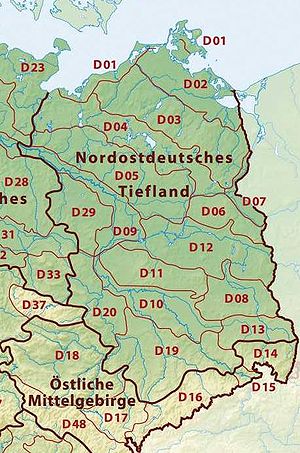
Northeast German Plain
- D01 Mecklenburg Coastal Lowland (71)
- D02 Northeast Mecklenburg Lowland (including the Szczecin Lagoon) (72-73)
- Northeast Mecklenburg Lowland (72, northwest and centre)
- Szczecin Lagoon (73 east)
- D03 Mecklenburg Lake Plateau Hinterland (74)
- D04 Mecklenburg Lake Plateau (75)
- D05 Mecklenburg-Brandenburg Plateau and Upland (76-78)
- Southwest Foreland of the Mecklenburg Lake Plateau (76, northwest)
- North Brandenburg Plateau and Upland (77, centre)
- Luchland (78, southeast)
- D06 East BrandenburgBrandenburgBrandenburg is one of the sixteen federal-states of Germany. It lies in the east of the country and is one of the new federal states that were re-created in 1990 upon the reunification of the former West Germany and East Germany. The capital is Potsdam...
Plateau (79) - D07 OderOderThe Oder is a river in Central Europe. It rises in the Czech Republic and flows through western Poland, later forming of the border between Poland and Germany, part of the Oder-Neisse line...
Valley (80) - D08 LusatiaLusatiaLusatia is a historical region in Central Europe. It stretches from the Bóbr and Kwisa rivers in the east to the Elbe valley in the west, today located within the German states of Saxony and Brandenburg as well as in the Lower Silesian and Lubusz voivodeships of western Poland...
n Basin and SpreewaldSpreewaldThe Spreewald is situated about 100 km south-east of Berlin. It was designated a biosphere reserve by UNESCO in 1991. It is known for its traditional irrigation system which consists of more than 200 small channels within the area. The landscape was shaped during the ice-age...
(83-84)- SpreewaldSpreewaldThe Spreewald is situated about 100 km south-east of Berlin. It was designated a biosphere reserve by UNESCO in 1991. It is known for its traditional irrigation system which consists of more than 200 small channels within the area. The landscape was shaped during the ice-age...
(83, northeast) - Lusatian Basin and Lower Lusatian Heath (84, centre, west and south)
- Spreewald
- D09 Middle ElbeElbeThe Elbe is one of the major rivers of Central Europe. It rises in the Krkonoše Mountains of the northwestern Czech Republic before traversing much of Bohemia , then Germany and flowing into the North Sea at Cuxhaven, 110 km northwest of Hamburg...
Plain (87) - D10 Elbe-MuldeMuldeThe Mulde is a river in Saxony and Saxony-Anhalt, Germany. It is a left tributary of the Elbe and 124 km in length.The river is formed by the confluence, near Colditz, of the Zwickauer Mulde and the Freiberger Mulde , both rising from the Ore Mountains...
Plain (88) - D11 Fläming Heath (85)
- D12 Brandenburg Heath and Lake District (81-82)
- Central Brandenburg Plateaux and Lowland (81, west)
- East Brandenburg Heath and Lake District (82, east)
- D13 Upper Lusatian Plateau (89)
- Saxon LowlandSaxon LowlandThe Saxon Lowland or Saxon Löss Fields refer to a natural region that lies mainly within the state of Saxony in central Germany. In addition, small areas of this region extend to the northwest and west into Saxony-Anhalt , to the southeast into Thuringia and to the northeast into Brandenburg...
* (new overarching region/division)- D19 Saxon Upland and Ore Mountain ForelandSaxon LowlandThe Saxon Lowland or Saxon Löss Fields refer to a natural region that lies mainly within the state of Saxony in central Germany. In addition, small areas of this region extend to the northwest and west into Saxony-Anhalt , to the southeast into Thuringia and to the northeast into Brandenburg...
(45-46)- Ore Mountain ForelandOre Mountain ForelandThe Ore Mountain Foreland is a strip of countryside of about 200 m to high, in the German state of Saxony, that lies immediately north of the German Ore Mountains and runs mainly through the areas of Zwickauer Land, Zwickau, Chemnitzer Land, Chemnitz, Mittelsachsen and the country south of Dresden...
(45, south) - Saxon UplandSaxon LowlandThe Saxon Lowland or Saxon Löss Fields refer to a natural region that lies mainly within the state of Saxony in central Germany. In addition, small areas of this region extend to the northwest and west into Saxony-Anhalt , to the southeast into Thuringia and to the northeast into Brandenburg...
(including Leipziger LandLeipziger LandLeipziger Land is a former district in the Free State of Saxony, Germany. It was bounded by the districts of Delitzsch, the district-free city Leipzig, Muldentalkreis, Mittweida, the district Altenburger Land in Thuringia, and the districts Burgenlandkreis, Saalekreis in Saxony-Anhalt.- History...
) (46, west, north and east)
- Ore Mountain Foreland
- D14 Upper LusatiaUpper LusatiaUpper Lusatia is a region a biggest part of which belongs to Saxony, a small eastern part belongs to Poland, the northern part to Brandenburg. In Saxony, Upper Lusatia comprises roughly the districts of Bautzen and Görlitz , in Brandenburg the southern part of district Oberspreewald-Lausitz...
(44) - excluding the Lusatian Upland (441)
- D19 Saxon Upland and Ore Mountain Foreland
- D20 Eastern Harz Foreland and Börde (50)
- D29 WendlandWendlandWendland may refer to either of the following regions or people:*Wendland may refer to a region once inhabited by Wends, an old Germanic term for Slavic tribes living in close proximity to the Germanic tribes:...
and AltmarkAltmarkThe Altmark is a historic region in Germany, comprising the northern third of Saxony-Anhalt. As the initial territory of the Brandenburg margraves, it is sometimes referred to as the "Cradle of Prussia", as by Otto von Bismarck, a native from Schönhausen near Stendal.- Geography :The Altmark is...
(86)
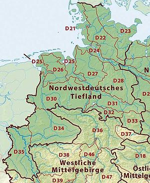
Northwest German Plain
- D21 Schleswig-Holstein Marsh (68)
- D22 Schleswig-Holstein Geest (69)
- D23 Schleswig-Holstein UplandsSchleswig-Holstein UplandsThe Schleswig-Holstein Uplands is one of the three landscapes of the German state of Schleswig-Holstein; the others being the marsch and the geest...
(70) - D24 Lower Elbe Marsh (67)
- D25 Ems and Weser Marsh (61)
- D26 East Frisian Geest (60)
- D27 Stade GeestStade GeestThe Stade Geest is a natural region of low, sandy heath in the North German Plain.It includes a large part of the Elbe-Weser Triangle between the cities of Hamburg, Bremen and Cuxhaven and is bordered by the natural regions of the Elbe Marsch, Weser Marsch, Weser-Aller Plain and Lüneburg Heath...
(63) - D28 Lüneburg HeathLüneburg HeathThe Lüneburg Heath is a large area of heath, geest and woodland in northeastern part of the state of Lower Saxony in northern Germany. It forms part of the hinterland for the cities of Hamburg, Hanover, and Bremen and is named after the town of Lüneburg. Most of the area is a nature reserve...
(64) - D30 Dümmer and Ems-Hunte Geest (58-59)
- Dümmer Geest Lowland (58, south)
- Ems-Hunte Geest (59, north)
- D31 Weser-Aller Plain (62)
- D32 Lower Saxony Börde (52)
- D33 North Harz Foreland (51)
- D34 Westphalian LowlandWestphalian LowlandThe Westphalian Lowland, also known as the Westphalian Basin is a flat landscape that mainly lies within the German region of Westphalia, although small areas also fall within North Rhine and in Lower Saxony...
or Basin (Münster Lowland) (54) - D35 Lower Rhine PlainLower Rhine PlainThe Lower Rhine Plain is one of the natural regions of Germany and lies on either side of the River Rhine north of the city of Düsseldorf.- Geography :...
and Cologne Lowland (55, 57)- Cologne Lowland (55, south)
- Lower Rhine PlainLower Rhine PlainThe Lower Rhine Plain is one of the natural regions of Germany and lies on either side of the River Rhine north of the city of Düsseldorf.- Geography :...
(57, north)
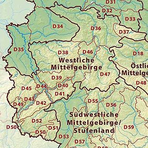
Western Central Uplands
- D36 Lower Saxon HillsLower Saxon HillsThe Lower Saxon Hills are one the 73 natural regions in Germany defined by the Federal Agency for Nature Conservation . Geographically it covers roughly the same area as the Weser Uplands in its wider sense....
(including the Weser and Leine UplandsLeine UplandsThe Leine Uplands is a region in Germany's Central Uplands which forms a part of the Lower Saxon Hills and lies along the River Leine between Göttingen and Hanover...
) (36-37, 53)- Lower Weser Uplands (53, northwest)
- Upper Weser Uplands (36, centre)
- Leine UplandsLeine UplandsThe Leine Uplands is a region in Germany's Central Uplands which forms a part of the Lower Saxon Hills and lies along the River Leine between Göttingen and Hanover...
(37, east)
- D37 HarzHarzThe Harz is the highest mountain range in northern Germany and its rugged terrain extends across parts of Lower Saxony, Saxony-Anhalt and Thuringia. The name Harz derives from the Middle High German word Hardt or Hart , latinized as Hercynia. The legendary Brocken is the highest summit in the Harz...
(38) - D38 SauerlandSauerlandThe Sauerland is a rural, hilly area spreading across most of the south-eastern part of North Rhine-Westphalia, in parts heavily forested and, apart from the major valleys, sparsely inhabited...
(SüderberglandSüderberglandThe Süderbergland , sometimes called the Südergebirge in German, is a major natural region of the Rhenish Massif in the German states of North Rhine-Westphalia and northwestern Hesse...
) (33) - D39 WesterwaldWesterwaldThe Westerwald is a low mountain range on the right bank of the River Rhine in the German federal states of Rhineland-Palatinate, Hesse and North Rhine-Westphalia. It is a part of the Rhine Massif...
(32) - D40 Gießen-Koblenz Lahn ValleyGießen-Koblenz Lahn ValleyThe Gießen-Koblenz Lahn Valley is a bowl in western Hesse and eastern Rhineland-Palatinate in Germany that contains the lower course of the Lahn as well as the Limburg Basin. It falls within natural region no. 31 as defined by the BfN. It extends from Leun to the mouth of the Lahn into the River...
(31) - D41 TaunusTaunusThe Taunus is a low mountain range in Hesse, Germany that composes part of the Rhenish Slate Mountains. It is bounded by the river valleys of Rhine, Main and Lahn. On the opposite side of the Rhine, the mountains are continued by the Hunsrück...
(30) - D42 HunsrückHunsrückThe Hunsrück is a low mountain range in Rhineland-Palatinate, Germany. It is bounded by the river valleys of the Moselle , the Nahe , and the Rhine . The Hunsrück is continued by the Taunus mountains on the eastern side of the Rhine. In the north behind the Moselle it is continued by the Eifel...
(24) - D43 Moselle ValleyMoselle valleyThe Moselle valley is a region in north-eastern France, south-western Germany, and eastern Luxembourg, centred on the river valley formed by the Moselle...
(25) - D44 Middle RhineMiddle RhineBetween Bingen and Bonn, Germany, the Rhine River flows as the Middle Rhine through the Rhine Gorge, a formation created by erosion, which happened at about the same rate as an uplift in the region, leaving the river at about its original level, and the surrounding lands raised...
(including SiebengebirgeSiebengebirgeThe Siebengebirge is a German range of hills to the East of the Rhine, southeast of Bonn, consisting of more than 40 mountains and hills. It is located in the municipalities of Bad Honnef and Königswinter. It is of volcanic origin and came into being between 28 and 15 million years ago...
) (29) - D45 EifelEifelThe Eifel is a low mountain range in western Germany and eastern Belgium. It occupies parts of southwestern North Rhine-Westphalia, northwestern Rhineland-Palatinate and the south of the German-speaking Community of Belgium....
(including Venn Foreland) (27-28, 56)- East Eifel (27, east and centre)
- West EifelWest EifelThe West Eifel refers to that part of the Eifel mountains in Germany that is centred on the town of Prüm and reaches as far as the border with Belgium and Luxembourg...
(28, west) - Venn Foreland (56, extreme northwest)
- D46 West Hesse HighlandsWest Hesse HighlandsThe West Hesse Highlands , also known as the West Hessian Lowlands and Highlands , refers to a heavily forested region of the Central Uplands in Germany that lies mostly within the state of Hesse, between those elements of the Rhine Massif right of the Rhine in the west, the Weser Uplands to the...
(34) - D47 East Hesse HighlandsEast Hesse HighlandsThe East Hesse Highlands describes a heavily wooded range of hills lying mainly in the German state of Hesse, but also extending a little way into Lower Saxony to the north, Thuringia to the east and Bavaria to the southeast...
(35) - D49 Bitburg LandGutland (Luxembourg)Gutland is a region covering the southern and central parts of the Grand Duchy of Luxembourg. Gutland covers 68% of the territory of Luxembourg; to the north of Gutland lies the Oesling, which covers the remaining 32% of the Grand Duchy....
(Gutland) (26) - D50 Palatine-Saar Muschelkalk Region (18)
- D51 Palatinate Forest (the Haardt) (17)
- D52 Saar-Nahe Hills or Upland (19)
Eastern Central Uplands
- Saxon Highlands and UplandsSaxon Highlands and UplandsThe Saxon Highlands and Uplands refer to a natural region mainly in the south of Saxony with small elements also in southeast Thuringia and northeast Bavaria...
* (new supra-region)- D14 Upper LusatiaUpper LusatiaUpper Lusatia is a region a biggest part of which belongs to Saxony, a small eastern part belongs to Poland, the northern part to Brandenburg. In Saxony, Upper Lusatia comprises roughly the districts of Bautzen and Görlitz , in Brandenburg the southern part of district Oberspreewald-Lausitz...
(44) -- only 441 Upper Lusatian Plateau
- D15 Saxon-Bohemian Chalk Sandstone RegionSaxon-Bohemian Chalk Sandstone RegionThe Saxon-Bohemian Chalk Sandstone Region is a natural region in south Saxony on the southern border with the Czech Republic. It forms part of the northern perimeter of the Bohemian Massif and comprises Saxon Switzerland, the German part of the Elbsandsteingebirge and the Zittau Hills, a small...
(43) - D16 Ore MountainsOre MountainsThe Ore Mountains in Central Europe have formed a natural border between Saxony and Bohemia for many centuries. Today, the border between Germany and the Czech Republic runs just north of the main crest of the mountain range...
(Erzgebirge) (42) - D17 VogtlandVogtlandThe term Vogtland refers to a region reaching across the German free states of Bavaria, Saxony and Thuringia and into the Czech Republic . The name of the region contains a reference to the former leadership by the Vögte of Weida, Gera and Plauen, which translates approximately to advocates or lord...
(41)
- D14 Upper Lusatia
- D18 Thuringian Basin including outer plateaus (47-48)
- Southern plateau of the Thuringian Basin (47, south)
- Thuringian BasinThuringian BasinThe Thuringian Basin is a depression in the central and northwest part of Thuringia in Germany which is crossed by several rivers, the longest of which is the Unstrut. It stretches about from north to south and around from east to west...
(48; north, west and centre)
- D48 Thuringian-Franconian Highlands (39)
- D63 Upper Palatine-Bavarian ForestUpper Palatine-Bavarian ForestThe Upper Palatine-Bavarian Forest , is a natural region in Germany in the northeast of Bavaria. It mainly comprises the low mountain ranges of the Bavarian Forest and Upper Palatine Forest which are up to 1456 m high and border on the Bohemian Massif immediately inside the Czech Republic's...
(40)
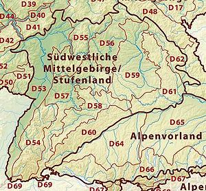
South German ScarplandsSouth German ScarplandsThe South German Scarplands is a geological and geomorphological natural region or landscape in Switzerland and the south German states of Bavaria and Baden-Württemberg...
- D53 Upper Rhine PlainUpper Rhine PlainThe Upper Rhine Plain, Rhine Rift Valley or Upper Rhine Graben is a major rift, straddling the border between France and Germany. It forms part of the European Cenozoic Rift System, which extends across central Europe...
(20-23)- Southern Upper Rhine Plain (20, extreme south)
- Middle Upper Rhine Plain (21, south of centre)
- Northern Upper Rhine Plain (22, centre and north)
- Rhine-Main LowlandUpper Rhine PlainThe Upper Rhine Plain, Rhine Rift Valley or Upper Rhine Graben is a major rift, straddling the border between France and Germany. It forms part of the European Cenozoic Rift System, which extends across central Europe...
(23, northeast)
- D54 Black ForestBlack ForestThe Black Forest is a wooded mountain range in Baden-Württemberg, southwestern Germany. It is bordered by the Rhine valley to the west and south. The highest peak is the Feldberg with an elevation of 1,493 metres ....
(15) - D55 OdenwaldOdenwaldThe Odenwald is a low mountain range in Hesse, Bavaria and Baden-Württemberg in Germany.- Location :The Odenwald lies between the Upper Rhine Rift Valley with the Bergstraße and the Hessisches Ried in the west, the Main and the Bauland in the east, the Hanau-Seligenstadt Basin – a subbasin of...
, SpessartSpessartThe Spessart is a low mountain range in northwestern Bavaria and southern Hesse, Germany. It is bordered on three sides by the Main River. The two most important towns located at the foot of the Spessart are Aschaffenburg and Würzburg....
and South Rhön (14) - D56 Mainfranken Plateau (13)
- D57 Gäu PlateausGäu PlateausThe Gäu Plateaus form the largest natural region in the German state of Baden-Württemberg. Not surprisingly, the individual geographical units of this large region show considerable variations in climate and soil types...
(12) - D58 Swabian Keuper-Lias PlainsSwabian Keuper-Lias PlainsThe Swabian Keuper-Lias Plains is a major natural region in southwest Germany and includes the southwesternmost part of the Keuper Uplands, which is bordered immediately to the north by the Swabian Jura.- Natural regions :...
(10) - D59 Franconian Keuper-Lias PlainsFranconian Keuper-Lias PlainsThe Franconian Keuper-Lias Plains or Franconian Keuper-Lias Lands are a major natural region in the South German Scarplands in Upper Franconia and to a lesser extent in the north, in the Thuringian district of Hildburghausen...
(11) - D60 Swabian Jura (09)
- D61 Franconian JuraFranconian JuraThe Franconian Jura is an upland in Bavaria, Germany. Located between two rivers, the Danube in the south and the Main in the north, its peaks reach elevations of up to .Large portions of the Franconian Jura are part of the Altmühl Valley Nature Park...
(08) - D62 Upper Palatinate-Upper Main Hills (07)
- D69 Dinkelberg and Upper Rhine Valley (16)
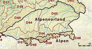
Alpine Foreland and Alps
- D64 Iller-Lech PlateauIller-Lech PlateauThe Iller-Lech Plateau , also known as the Upper Swabian Plateau , is one of the natural regions of Germany.- Boundaries :...
(04) - D65 Lower Bavarian Uplands and Isar-Inn Gravel Plateau (05-06)
- Isar-Inn Gravel Plateau (05, Süden)
- Lower Bavarian UplandLower Bavarian UplandThe Lower Bavarian Upland are part of the tertiary hill country south of the River Danube and cover much of the land within the Bavarian province of Lower Bavaria in southern Germany...
(06, Middle and North)
- D66 Southern Alpine ForelandBavarian Alpine ForelandThe Bavarian Alpine Foreland refers to the region of plateau and rolling foothills south of the Danube and north of the Bavarian Alps. It has been shaped under the influence of the ice ages and has a rich variety of landscape forms...
(03) - D67 Swabian-Bavarian Foreland (02)
- D68 Northern Limestone AlpsNorthern Limestone AlpsThe Northern Limestone Alps are the ranges of the Eastern Alps north of the Central Eastern Alps located in Austria and the adjacent Bavarian lands of southeastern Germany. The distinction from the latter group, where the higher peaks are located, is based on differences in geological composition...
(01)
North and Baltic Seas
- D70 German BightGerman BightGerman Bight is the southeastern bight of the North Sea bounded by the Netherlands and Germany to the south, and Denmark and Germany to the east . To the north and west it is limited by the Dogger Bank. The Bight contains the Frisian and Danish Islands. The Wadden Sea is approximately ten to...
(excluding the HeligolandHeligolandHeligoland is a small German archipelago in the North Sea.Formerly Danish and British possessions, the islands are located in the Heligoland Bight in the south-eastern corner of the North Sea...
rock outcrop) (900 - to 90) - D71 Dogger BankDogger BankDogger Bank is a large sandbank in a shallow area of the North Sea about off the east coast of England. It extends over approximately , with its dimensions being about long and up to broad. The water depth ranges from 15 to 36 metres , about shallower than the surrounding sea. It is a...
and adjacent central North SeaNorth SeaIn the southwest, beyond the Straits of Dover, the North Sea becomes the English Channel connecting to the Atlantic Ocean. In the east, it connects to the Baltic Sea via the Skagerrak and Kattegat, narrow straits that separate Denmark from Norway and Sweden respectively...
(901 - to 90) - D72 Western BalticBaltic SeaThe Baltic Sea is a brackish mediterranean sea located in Northern Europe, from 53°N to 66°N latitude and from 20°E to 26°E longitude. It is bounded by the Scandinavian Peninsula, the mainland of Europe, and the Danish islands. It drains into the Kattegat by way of the Øresund, the Great Belt and...
(902 - to 90) - D73 Eastern BalticBaltic SeaThe Baltic Sea is a brackish mediterranean sea located in Northern Europe, from 53°N to 66°N latitude and from 20°E to 26°E longitude. It is bounded by the Scandinavian Peninsula, the mainland of Europe, and the Danish islands. It drains into the Kattegat by way of the Øresund, the Great Belt and...
(903 - to 90)
Sources
- Elkins, T.H. (1972). Germany (3rd ed.). London: Chatto & Windus, 1972. ASIN B0011Z9KJA.
- Incorporation of the old major geographical units 010-903 into the new natural regions D01-D73 by the BfN
- Meynen, Emil (Hrsg.) Handbuch der naturräumlichen Gliederung Deutschlands. Selbstverlag der Bundesanstalt für Landeskunde, Remagen 1953-1962 (Teil 1, enthält Lieferung 1-5), ISBN B0000BJ19E
- Meynen, Emil (Hrsg.) Handbuch der naturräumlichen Gliederung Deutschlands. Selbstverlag der Bundesanstalt für Landeskunde, Remagen 1959-1962 (Teil 2, enthält Lieferung 6-9), ISBN B0000BJ19F
- Ssymank, A. Neue Anforderungen im europäischen Naturschutz. Das Schutzgebietssystem Natura 2000 und die "FFH-Richtlinie der EU". – Zeitschrift „Natur und Landschaft“ Jg. 69. 1994, Heft 9: S. 395-406. Bonn-Bad Godesberg. ISSN 0028-0615
External links
- BfN-Landschaftssteckbriefe (Description of Natural Regions under the old classification scheme)
- Interaktive Kartendienste des BfN ("Landscapes" map service based on the old system)
- Natural regions of Germany with major units (old and new system)