

Leine Uplands
Encyclopedia
The Leine Uplands is a region in Germany's Central Uplands
which forms a part of the Lower Saxon Hills
and lies along the River Leine between Göttingen
and Hanover
. It borders on the Weser Uplands in the west, the Innerste Uplands
in the northeast, the Harz
in the east and Untereichsfeld in the southeast.
but are nevertheless relatively easily delineated. Their extent from south to north is determined by the river that lends them their name and their extent from east to west by high ridges.
From north to south the uplands can be broadly divided into a southern half around the wide trough of the River Leine's middle course and a northern half by the lower reaches of the same river.
. On the hilltops along the valley of the Leine there are many castle
s that controlled the north-south road network in the valley during the Middle Ages
and could also block it entirely.
In the southeastern part of the Leine Uplands, east of the valley, is the plateau of the Göttingen-Northeim Forest which is founded on Bunter sandstone and Muschelkalk
. The western edge of the forest (in a northerly direction) reaches from Friedland via Göttingen
and Nörten-Hardenberg
to Northeim
. It is here that the largest group of abris in central Europe may be found. They are often located in the narrowest places in the ravine-like rocky valleys between the Leine and the Eichsfeld. In an area about 30 km long and 6 to 10 km wide around 1600 abris have been discovered. The woods (largely beech
forests) are utilised by the forestry industry.
To the north this landscape transitions into the equally thickly wooded escarpments and fault-block landscape of the Southwest Harz Foreland, in which Jurassic
limestone
is found alongside Bunter and Muschelkalk. Immediately north of Einbeck
the Hube, an outlier of the Southwest Harz Foreland, reaches the western side of the Leine and "blocks" the Leine trough to the north.
West of the trough is the heath landscape of the latter opposite the intensively farmed Solling Foreland.
Not counted as part of the Leine Uplands is the extreme east of the Southwest Harz Foreland and the extreme northwest of the Solling Foreland around the Vogler.
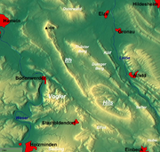
East of the massifs that give the region its alternative name, the Ith
and the Hils
, which are up to 480 m high, the ridges fall steeply on both sides of the Leine into the valley and are dissected by various tributaries. Beech woods dominate the heights whilst the valleys are used for arable farming.
Große Teile der Landschaft sind geschützt. Neben den mesophilen Buchen- und Schluchtwäldern finden sich in den Höhenzügen rechts der Leine insbesondere schützenswerte Kalktrockenhangwälder, Trockenrasen, Trockengebüsche und mesophiles Grünland.
Near Gronau the Leine finally leaves the Leine Uplands and, simultaneously, the Central Uplands
and enters funnel-shaped basin of the Calenberg Loess Börde which opens out into the North German Plain
and which abuts on the Calenberg Uplands
in the west and the Innerste Uplands
and Hildesheim Forest
in the east.
Central Uplands
The Central Uplands is one of the three major natural regions of Germany and covers most of the land area of the country. To the north lies the North German Plain or Northern Lowland; to the south, the Alps and the Alpine Foreland.- Formation :...
which forms a part of the Lower Saxon Hills
Lower Saxon Hills
The Lower Saxon Hills are one the 73 natural regions in Germany defined by the Federal Agency for Nature Conservation . Geographically it covers roughly the same area as the Weser Uplands in its wider sense....
and lies along the River Leine between Göttingen
Göttingen
Göttingen is a university town in Lower Saxony, Germany. It is the capital of the district of Göttingen. The Leine river runs through the town. In 2006 the population was 129,686.-General information:...
and Hanover
Hanover
Hanover or Hannover, on the river Leine, is the capital of the federal state of Lower Saxony , Germany and was once by personal union the family seat of the Hanoverian Kings of Great Britain, under their title as the dukes of Brunswick-Lüneburg...
. It borders on the Weser Uplands in the west, the Innerste Uplands
Innerste Uplands
The Innerste Uplands is a landscape region up to 359 m high and covering an area of over 900 km² in the northern part of the German Central Uplands...
in the northeast, the Harz
Harz
The Harz is the highest mountain range in northern Germany and its rugged terrain extends across parts of Lower Saxony, Saxony-Anhalt and Thuringia. The name Harz derives from the Middle High German word Hardt or Hart , latinized as Hercynia. The legendary Brocken is the highest summit in the Harz...
in the east and Untereichsfeld in the southeast.
Geography
The Leine Uplands, which merge into the Weser Uplands to the east and the Harz to the west, are not a clearly defined landscape in terms of being a natural regionNatural region
A Natural region is one which is distinguished by its natural features of geography and usually more important, geology. The natural ecology of the region is likely to be significant but one of these factors tends to influence the others....
but are nevertheless relatively easily delineated. Their extent from south to north is determined by the river that lends them their name and their extent from east to west by high ridges.
From north to south the uplands can be broadly divided into a southern half around the wide trough of the River Leine's middle course and a northern half by the lower reaches of the same river.
Landscapes either side of the Leine trough
The River Leine flows from Friedland via Göttingen and Northeim to Einbeck through the Leine trough (Leine-Ilm Basin), an important north-south orientated geological rift valleyRift valley
A rift valley is a linear-shaped lowland between highlands or mountain ranges created by the action of a geologic rift or fault. This action is manifest as crustal extension, a spreading apart of the surface which is subsequently further deepened by the forces of erosion...
. On the hilltops along the valley of the Leine there are many castle
Castle
A castle is a type of fortified structure built in Europe and the Middle East during the Middle Ages by European nobility. Scholars debate the scope of the word castle, but usually consider it to be the private fortified residence of a lord or noble...
s that controlled the north-south road network in the valley during the Middle Ages
Middle Ages
The Middle Ages is a periodization of European history from the 5th century to the 15th century. The Middle Ages follows the fall of the Western Roman Empire in 476 and precedes the Early Modern Era. It is the middle period of a three-period division of Western history: Classic, Medieval and Modern...
and could also block it entirely.
In the southeastern part of the Leine Uplands, east of the valley, is the plateau of the Göttingen-Northeim Forest which is founded on Bunter sandstone and Muschelkalk
Muschelkalk
The Muschelkalk is a sequence of sedimentary rock strata in the geology of central and western Europe. It has a Middle Triassic age and forms the middle part of the Germanic Trias, that further consists of the Buntsandstein and Keuper...
. The western edge of the forest (in a northerly direction) reaches from Friedland via Göttingen
Göttingen
Göttingen is a university town in Lower Saxony, Germany. It is the capital of the district of Göttingen. The Leine river runs through the town. In 2006 the population was 129,686.-General information:...
and Nörten-Hardenberg
Nörten-Hardenberg
Nörten-Hardenberg is a municipality in the district of Northeim, in Lower Saxony, Germany. It is situated on the river Leine, approx. 10 km southwest of Northeim, and 10 km north of Göttingen.- References :...
to Northeim
Northeim
Northeim is a city in Lower Saxony, Germany, seat of the district of Northeim, with, as of 2002, a population of 31 000. It's located on the German Half-Timbered House Road.-History:...
. It is here that the largest group of abris in central Europe may be found. They are often located in the narrowest places in the ravine-like rocky valleys between the Leine and the Eichsfeld. In an area about 30 km long and 6 to 10 km wide around 1600 abris have been discovered. The woods (largely beech
Beech
Beech is a genus of ten species of deciduous trees in the family Fagaceae, native to temperate Europe, Asia and North America.-Habit:...
forests) are utilised by the forestry industry.
To the north this landscape transitions into the equally thickly wooded escarpments and fault-block landscape of the Southwest Harz Foreland, in which Jurassic
Jurassic
The Jurassic is a geologic period and system that extends from about Mya to Mya, that is, from the end of the Triassic to the beginning of the Cretaceous. The Jurassic constitutes the middle period of the Mesozoic era, also known as the age of reptiles. The start of the period is marked by...
limestone
Limestone
Limestone is a sedimentary rock composed largely of the minerals calcite and aragonite, which are different crystal forms of calcium carbonate . Many limestones are composed from skeletal fragments of marine organisms such as coral or foraminifera....
is found alongside Bunter and Muschelkalk. Immediately north of Einbeck
Einbeck
Einbeck is a town in the district Northeim, in southern Lower Saxony, Germany. It is located on the German Timber-Frame Road.-Economy:Einbeck is famous for its 600 year old beer brewery, home of Einbecker Bier, the origin for the term Bock beer...
the Hube, an outlier of the Southwest Harz Foreland, reaches the western side of the Leine and "blocks" the Leine trough to the north.
West of the trough is the heath landscape of the latter opposite the intensively farmed Solling Foreland.
Not counted as part of the Leine Uplands is the extreme east of the Southwest Harz Foreland and the extreme northwest of the Solling Foreland around the Vogler.
Alfeld Uplands
After the Leine trough has been blocked and flows around the Hube, it runs through the Alfeld Uplands (Ith-Hils-Bergland) which is characterised by a succession of closely spaced ridges and finger valleys running in a northwest-southeast direction.East of the massifs that give the region its alternative name, the Ith
Ith
The Ith is a ridge in Germany's Central Uplands which is up to high. It lies about 40 km southwest of Hanover and, at 22 kilometres, is the longest line of crags in North Germany.- Geography :- Location :...
and the Hils
Hils
For HILS, see Hardware-in-the-loop simulation.The Hils is a range of hills in Germany's Central Uplands that is up to high. It is located in the districts of Holzminden, Hildesheim and Northeim, in the state of Lower Saxony.- Geography :...
, which are up to 480 m high, the ridges fall steeply on both sides of the Leine into the valley and are dissected by various tributaries. Beech woods dominate the heights whilst the valleys are used for arable farming.
Große Teile der Landschaft sind geschützt. Neben den mesophilen Buchen- und Schluchtwäldern finden sich in den Höhenzügen rechts der Leine insbesondere schützenswerte Kalktrockenhangwälder, Trockenrasen, Trockengebüsche und mesophiles Grünland.
Near Gronau the Leine finally leaves the Leine Uplands and, simultaneously, the Central Uplands
Central Uplands
The Central Uplands is one of the three major natural regions of Germany and covers most of the land area of the country. To the north lies the North German Plain or Northern Lowland; to the south, the Alps and the Alpine Foreland.- Formation :...
and enters funnel-shaped basin of the Calenberg Loess Börde which opens out into the North German Plain
North German plain
The North German Plain or Northern Lowland is one of the major geographical regions of Germany. It is the German part of the North European Plain...
and which abuts on the Calenberg Uplands
Calenberg Uplands
The Calenberg Uplands are a landscape unit in the Weser-Leine Uplands in Lower Saxony, Germany. They border on the Calenberg Land to the north and merge into the Weser Uplands in the west and the Leine Uplands in the east...
in the west and the Innerste Uplands
Innerste Uplands
The Innerste Uplands is a landscape region up to 359 m high and covering an area of over 900 km² in the northern part of the German Central Uplands...
and Hildesheim Forest
Hildesheim Forest
The Hildesheim Forest is a range of hills up to in the district of Hildesheim in the German state of Lower Saxony.- Geography :The Hildesheim Forest is located in the Innerste Uplands, part of the Lower Saxon Hills, between the valleys of the Leine to the west, the Innerste to the north and the ...
in the east.
Natural regions
The landscape regions of the Leine Uplands are grouped into the following major units, whereby the numbers not prefixed by the letter D represent the old categorisation into major unit groups (double figures) and major units (triple figures), whilst the new major unit group, D 36, contains the two older groups.- D 36 Lower Saxon HillsLower Saxon HillsThe Lower Saxon Hills are one the 73 natural regions in Germany defined by the Federal Agency for Nature Conservation . Geographically it covers roughly the same area as the Weser Uplands in its wider sense....
- 37 Weser-Leine Uplands
- 377 Alfeld Uplands (Ith-Hils ridges)
- 371 Solling Foreland (less the extreme northwest which is part of the Vogler)
- 372 Leine-Ilme Basin
- 376 Southwest Harz Foreland (less the extreme east)
- 373 Göttingen-Northeim Forest
- 37 Weser-Leine Uplands
Hills
The following hills are counted as part of the Leine Uplands (roughly north to south):| Name | Height above NN | Landscape region |
|---|---|---|
| Kleiner Deister Kleiner Deister The Kleiner Deister is a ridge of hills in the Calenberg Uplands which, together with the Nesselberg and the Osterwald, forms a group of three adjacent hill ranges in the northern part of the Leine Uplands... |
345,7 m | Calenberg Uplands (l) |
| Nesselberg Nesselberg The Nesselberg is a ridge up to high in the Calenberg Highland which, together with the Kleiner Deister and the Osterwald, forms a group of three contiguous hill regions in the northwestern part of the Leine Uplands... |
378,2 m | Calenberg Uplands (l) |
| Osterwald Osterwald Osterwald is a community and part of the Joint Community of Neuenhaus in the district of Grafschaft Bentheim in Lower Saxony. The community consists of the centres of Osterwald, Alte Piccardie and Hohenkörben .... |
419,2 m | Calenberg Uplands (l) |
| Ith Ith The Ith is a ridge in Germany's Central Uplands which is up to high. It lies about 40 km southwest of Hanover and, at 22 kilometres, is the longest line of crags in North Germany.- Geography :- Location :... |
439 m | Alfeld Uplands (l) |
| Thüster Berg Thüster Berg The Thüster Berg is a ridge, up to , in the Lower Saxon Hills in central Germany. It is situated in the districts of Hameln-Pyrmont and Hildesheim in the federal state of Lower Saxony.- Location :... |
441 m | Alfeld Uplands (l) |
| Külf Külf The Külf is a ridge, up to , in the Leine Uplands in the district of Hildesheim in the German state of Lower Saxony.- Location :With seven main summits, the Külf stretches for about 9 kilometres, lying in a triangle formed by the settlements of Gronau, Alfeld and Duingen... |
260 m | Alfeld Uplands (l) |
| Sieben Berge Sieben Berge The Sieben Berge are a ridge of hills up to in the Lower Saxon Hills in the district of Hildesheim, Lower Saxony . Together with the Vorberge and the Sackwald the Sieben Berge belong to the geological formation of the Sackmulde.... |
395 m | Alfeld Uplands (r) |
| Vorberge Vorberge The Vorberge are a ridge, up to high, in the Lower Saxon Hills and within the district of Hildesheim in the German state of Lower Saxony.... |
353,0 m | Alfeld Uplands (r) |
| Duinger Berg Duinger Berg The Duinger Berg is a hill range, up to , in the Lower Saxon Hills and the district of Landkreis in the German state of Lower Saxony.- Location :... |
330 m | Alfeld Uplands (l) |
| Sackwald Sackwald The Sackwald is a ridge, up to high, in the Lower Saxon Hills in the district of Hildesheim in the North German state of Lower Saxony. It is named after the village of Sack in the borough of Alfeld, the name meaning "Sack Forest".... |
374 m | Alfeld Uplands (r) |
| Hils Hils For HILS, see Hardware-in-the-loop simulation.The Hils is a range of hills in Germany's Central Uplands that is up to high. It is located in the districts of Holzminden, Hildesheim and Northeim, in the state of Lower Saxony.- Geography :... |
480,4 m | Alfeld Uplands (l) |
| Selter | 395,0 m | Alfeld Uplands (l) |
| Helleberg | 297,5 m | Alfeld Uplands (r) |
| Elfas Elfas The Elfas is a range of hills up to in the districts of Holzminden an Northeim in Lower Saxony .- Geographical location :The Elfas is located in the middle of the Leine Uplands between the Hils to the north, the Homburg Forest to the west, the Hube to the east, the Amtsberge to the south-southwest... |
409,6 m | Solling Foreland (l) |
| Hube Hube (hills) The Hube is a ridge, up to , in the Leine Uplands and district of Northeim, in the German state of Lower Saxony.- Geography :The densely wooded Hube lies immediately northeast of the town of Einbeck, with its pretty, timber-framed houses, west of the River Leine and north of the Ilme valley... |
346,2 m | Southwest Harz Foreland (l) |
| Heber | 317,6 m | Innerste Uplands (r) |
| Ahlsburg Ahlsburg The Ahlsburg is a range of hills, relatively small in area and up to , in the southern part of Lower Saxony .- Geography :The Ahlsburg hills run in a northwest to southeast direction and are around 10 km long and up to about 3 km wide. They are heavily wooded and belong to the Leine Uplands... |
411,4 m | Solling Foreland (l) |
| Amtsberge Amtsberge The Amtsberge are a relatively small ridge, up to , near Dassel in southern Lower Saxony in Germany.- Geography :The densely wooded ridge of the Amtsberge is located on the boundary between the districts of Northeim and Holzminden and also on the boundary between the Leine... |
392,2 m | Solling Foreland (l) |
| Holzberg | 444,5 m | Solling Foreland (l) |
| Weper Weper The Weper is a long, high ridge of hills up to located in the district of Northeim in the German state of Lower Saxony.Part of the Weper is a nature reserve with the same name which, with an area of , is the large protected region of dry grassland in Lower Saxony.- Geography :The Weper, which lies... |
379 m | Solling Foreland (l) |
| Imbshausen Forest | 323,3 m | (r) |
| Edesheim Forest | 270 m | (r) |
| Wieter | 358,4 m | Göttingen-Northeim Forest (r) |
| Göttingen Forest Göttingen Forest The Göttingen Forest is a ridge in Germany's Central Uplands that is up to 427.5 metres high. It forms part of the Lower Saxon Hills in South Lower Saxony.- Geography :... |
427,5 m | Göttingen-Northeim Forest (r) |
Towns
Towns in the Leine valley (from north to south):
|
other towns in the Leine Uplands:
|
Literature
- Horst Vesterling: Das Leinebergland. Landschaft – Kultur – Freizeit. PDV-Sachbuchverlag, Hannover 1986. ISBN 3-925490-02-7.
- Gerhard Kraus: Rund um die sieben Berge. Ein historischer Freizeitführer durch das Leinebergland. Harenberg, Hannover 1983. ISBN 3-89042-007-9.
- Heinz Jordan: Geologische Wanderkarte Leinebergland. Maßstab 1:100.000. 1. Auflage. Verkehrsverein Leinebergland, Niedersächsisches Landesamt für Bodenforschung (Hrsg.), Hannover 1979.
- Verkehrsverein Leinebergland (Hrsg.): Leinebergland. Geschichte, Landschaft, Freizeit. Verkehrsverein Leinebergland, Alfeld (Leine) 1976.
- Arthur Rühl: Das südliche Leinebergland. Eine forstlich-vegetationskundliche und pflanzengeographische Studie. Pflanzensoziologie Band 9. Verlag G. Fischer, Jena 1954.
- Bundesanstalt für Landeskunde und Raumforschung: Geographische Landesaufnahme 1:200000. Naturräumliche Gliederung Deutschlands. Die naturräumlichen Einheiten auf Blatt 86 Hannover. Bad Godesberg 1960
- Bundesanstalt für Landeskunde und Raumforschung: Geographische Landesaufnahme 1:200000. Naturräumliche Gliederung Deutschlands. Die naturräumlichen Einheiten auf Blatt 99 Göttingen. Bad Godesberg 1963
- Dr. Dietrich Flieder: Landeskunde Niedersachsen., 1. Auflage. Paul List Verlag, München 1970, ISBN 3-471-18876-2 . S. 284 ff.
External links
- BfNBFNBFN is a three-letter acronym that may refer to:* Internet slang for "Bye for now"* In computer science, the Backus Normal Form or Backus–Naur Form is a notation technique for context-free grammars...
-Landschaftssteckbriefe: