

Iller-Lech Plateau
Encyclopedia
Natural regions of Germany
This division of Germany into major natural regions takes account primarily of geomorphological, geological, hydrological and pedological criteria in order to divide the country into large, physical units with a common geographical basis...
.
Boundaries
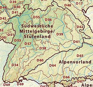
In the northwest the Iller-Lech Plateau borders on the Swabian Jura (unit D60 on the map) and, in the extreme northeast, on the Franconian JuraFranconian Jura
The Franconian Jura is an upland in Bavaria, Germany. Located between two rivers, the Danube in the south and the Main in the north, its peaks reach elevations of up to .Large portions of the Franconian Jura are part of the Altmühl Valley Nature Park...
(unit D61 on the map). The boundary with these two natural regions is roughly formed by the course of the river Danube
Danube
The Danube is a river in the Central Europe and the Europe's second longest river after the Volga. It is classified as an international waterway....
.
In the east the Iller-Lech Plateau borders on the Lower Bavarian Uplands and Isar-Inn Gravel Plateaus (unit D65 on the map). North of Augsburg
Augsburg
Augsburg is a city in the south-west of Bavaria, Germany. It is a university town and home of the Regierungsbezirk Schwaben and the Bezirk Schwaben. Augsburg is an urban district and home to the institutions of the Landkreis Augsburg. It is, as of 2008, the third-largest city in Bavaria with a...
its eastern boundary runs roughly parallel to state road 2035 (Augsburg-Pöttmes
Pöttmes
Pöttmes is a municipality in the district of Aichach-Friedberg in Bavaria in Germany....
-Neuburg an der Donau
Neuburg an der Donau
Neuburg an der Donau, literally Neuburg on the Danube River, is a town which is the capital of the Neuburg-Schrobenhausen district in the state of Bavaria in Germany.-Divisions:The municipality has 16 divisions:-History:...
), south of Augsburg east of the Lech, roughly between Mering
Mering
Mering is a municipality in the district Aichach-Friedberg, in Bavaria, Germany. It is located on the river Paar.First mentioned in record in 1021, Mering has a long history....
, Geltendorf
Geltendorf
Geltendorf is a municipality in the district of Landsberg in Bavaria, Germany.-World heritage site:It is home to one or more prehistoric pile-dwelling settlements that are part of the Prehistoric Pile dwellings around the Alps UNESCO World Heritage Site....
and Schongau
Schongau
Schongau may refer to:*Schongau, Bavaria, a town in Germany*Schongau, Lucerne, a commune in Switzerland...
.
To the south the Southern Alpine Foreland
Bavarian Alpine Foreland
The Bavarian Alpine Foreland refers to the region of plateau and rolling foothills south of the Danube and north of the Bavarian Alps. It has been shaped under the influence of the ice ages and has a rich variety of landscape forms...
(D66 on the map) borders on the Iller-Lech Plateau. The boundary between these two natural regions is partly formed by the terminal moraine
Terminal moraine
A terminal moraine, also called end moraine, is a moraine that forms at the end of the glacier called the snout.Terminal moraines mark the maximum advance of the glacier. An end moraine is at the present boundary of the glacier....
s of the Würm glaciation.
Sub-divisions
The sub-divisions are based upon the natural regions of Germany as shown on the BfNBFN
BFN is a three-letter acronym that may refer to:* Internet slang for "Bye for now"* In computer science, the Backus Normal Form or Backus–Naur Form is a notation technique for context-free grammars...
's Landscapes in Germany map. In the following table these sub-divisions are described from west to east. For the exact location and boundaries of the individual sub-divisions: see the BfN's map Landscapes in Germany (http://www.bfn.de/geoinfo/landscapes/)
Sub-divisions in Baden-Württemberg
| Geographical location | Formation | Relief | Soil / Land use | Remarks |
|---|---|---|---|---|
| Danube-Ablach Ablach (Danube) The Ablach is a right tributary of the Danube. It rises on the European Watershed, which is only a hint in this area, from the Mindersdorfer Aach in the municipality of Hohenfels in the Landkreis of Konstanz... Plateaus |
||||
Region between Danube, Mühlingen Mühlingen Mühlingen is a town in the district of Konstanz in Baden-Württemberg in Germany.... , Pfullendorf Pfullendorf Pfullendorf is a small historic city in the district of Sigmaringen in Baden-Württemberg in Germany.-Geography:Its location is in the district of Sigmaringen, 25 km north of Lake Constance and south of the Danube valley and therefore on the continental divide between the watersheds of the... , Ostrach Ostrach Ostrach is a municipality in the district of Sigmaringen in Baden-Württemberg in Germany.-Geography:Ostrach lies between the Danube and Lake Constance, about halfway between Sigmaringen and Ravensburg. It lies on the brook of the same name, which passes through a narrow pass between the glacial... , Bad Saulgau Bad Saulgau Bad Saulgau is a town in the district of Sigmaringen, in Baden-Württemberg, Germany. It is situated 23 km east of Sigmaringen, and 27 km north of Ravensburg between the Danube and Lake Constance.... and Federsee Federsee Federsee is a lake located just north of Bad Buchau in the region of Upper Swabia in Southern Germany. It is surrounded by moorland, partially overgrown with reeds. With a size of 33 km² , the area is one of the largest, groundwater fed, connected moorlands in Southern Germany. At its deepest... |
Old Drift landscape dominated by the Rift and Mindel glaciation of the Rhine Glacier |
Gently rolling hill country |
|
|
| Danube Valley between Mengen Mengen Mengen is a quiet, rural town and district in Bolu province in the Black Sea region of western Turkey, 58 km from the city of Bolu. It covers an area of 895 km², and the population is 16,504 of which 5,500 live in the town of Mengen... and Ulm Ulm Ulm is a city in the federal German state of Baden-Württemberg, situated on the River Danube. The city, whose population is estimated at 120,000 , forms an urban district of its own and is the administrative seat of the Alb-Donau district. Ulm, founded around 850, is rich in history and... , Lower Riß Valley Riß The Riss is a small river in Baden-Württemberg, south-western Germany, right tributary of the Danube. Its source is in Upper Swabia, between Bad Waldsee and Bad Schussenried. It flows north, through the town of Biberach an der Riss. It then flows into the Danube between Ehingen and Erbach,... |
||||
|
Danube Valley between Mengen and Ulm, region between Herbertingen Herbertingen Herbertingen is a municipality in the district of Sigmaringen in Baden-Württemberg in Germany.-Municipality:Herbertingen forms the municipality with Hundersingen, Marbach and Mieterkingen.-Archeological location:... and Bad Saulgau, Riß Valley from Schemmerhofen Schemmerhofen Schemmerhofen is a municipality in the district of Biberach in Upper Swabia.-Geography:Schemmerhofen is situated north of Biberach an der Riß. The formerly autonomous villages of Schemmerberg, Ingerkingen, Altheim, Aßmannshardt and Alberweiler are administratively part of Schemmerhofen... to where it joins the Danube |
|
Flat |
Much grassland and arable farming |
The Riß valley from the south which merges into the Danube valley is more marshy that the Danube valley |
| Federsee Ried Federsee Federsee is a lake located just north of Bad Buchau in the region of Upper Swabia in Southern Germany. It is surrounded by moorland, partially overgrown with reeds. With a size of 33 km² , the area is one of the largest, groundwater fed, connected moorlands in Southern Germany. At its deepest... |
||||
The Federsee lies in the middle of this natural region near Bad Buchau Bad Buchau Bad Buchau is a small town in the district of Biberach, Baden-Württemberg, Germany with about 4,000 inhabitants. It is situated near the Federsee, which is separated from the town by a wide reed belt.... |
|
Flat |
|
Because the lake has since been filled with sediment and gravel in places, the natural dammed lake was once much large |
| Western Plain of the Lower Riß | ||||
Region between Danube, Riß and, roughly, the B 312 |
Tertiary hills, in places however also ice age gravel deposits |
Hilly |
Agricultural land use predominates because the soils are loamy and fertile |
The Bussen Bussen The Bussen is a mountain in southern Germany, in the region of Upper Swabia, with an elevation of 787 metres . It is also known as the Holy Mountain of Upper Swabia. It is situated on the border between the Swabian Alb and Upper Swabia proper... is in this region |
| Western and Eastern Riß-Aitrach Aitrach (Iller) Aitrach is a river of Baden-Württemberg, Germany.... Plateaus |
||||
|
Riß glaciation terminal or ground moraine landscape |
Undulating |
|
The Wurzach Ried is in the east of the Riß-Aitrach Plateau |
| Holzstöcke | ||||
Region between Senden Senden The town of Senden is the second-largest town of the district of Neu-Ulm in Bavaria and is located at the border to Baden-Württemberg. The town belongs to the Donau-Iller-Nahverkehrsverbund... , Aichstetten Aichstetten Aichstetten is a municipality in the district of Ravensburg in Baden-Württemberg in Germany.... , Ochsenhausen and Laupheim Laupheim Laupheim is a city in southern Germany in the state of Baden Württemberg. Laupheim was first mentioned in 778 and gained its city rights in 1869. One of the main trading routes, from Ulm to Ravensburg and then on towards Lake Constance ran through Laupheim... |
|
Rolling hills |
|
Landscape still not very dissected |
| Eastern Plain of the Lower Riß | ||||
Region between Neu-Ulm Neu-Ulm Neu-Ulm is a town in Bavaria, capital of the Neu-Ulm district. Neighbouring towns include Ulm, Senden, Pfaffenhofen an der Roth, Holzheim, Nersingen and Elchingen. The population is 51,110 .-History:... , Senden and Laupheim |
Comprises various old gravel terraces along the valleys of the Riß and Danube, formed during the Riß glaciation |
Intensive arable land use |
The south is less dissected by valleys than the north |
|
Sub-divisions in both Baden-Württemberg and Bavaria
| Geographical location | Formation | Relief | Soil / Land use | Remarks |
|---|---|---|---|---|
| Higher Plains of the Lower Iller Valley (south of Memmingen Memmingen Memmingen is a town in the Bavarian administrative region of Swabia in Germany. It is the central economic, educational and administrative centre in the Danube-Iller region. To the west the town is flanked by the Iller, the river that marks the Baden-Württemberg border... ) and Lower Plains of the Lower Iller Valley (north of Memmingen) |
||||
Iller Valley from Altusried Altusried Altusried is a municipality in the district of Oberallgäu in Bavaria in Germany.... and Dietmannsried Dietmannsried Dietmannsried is a municipality in the district of Oberallgäu in Bavaria in Germany.-Sister cities: Carry-le-Rouet, Bouches-du-Rhône, France... to where it joins the Danube at Neu-Ulm Neu-Ulm Neu-Ulm is a town in Bavaria, capital of the Neu-Ulm district. Neighbouring towns include Ulm, Senden, Pfaffenhofen an der Roth, Holzheim, Nersingen and Elchingen. The population is 51,110 .-History:... |
Broad valley filled by large quantities of gravel during and after the ice age Ice age An ice age or, more precisely, glacial age, is a generic geological period of long-term reduction in the temperature of the Earth's surface and atmosphere, resulting in the presence or expansion of continental ice sheets, polar ice sheets and alpine glaciers... s |
Flat |
The north is used more for arable farming; the south more as grassland |
|
| Donauried | ||||
|
Large fen Fen A fen is a type of wetland fed by mineral-rich surface water or groundwater. Fens are characterised by their water chemistry, which is neutral or alkaline, with relatively high dissolved mineral levels but few other plant nutrients... plain by the Danube between Neu-Ulm and Donauwörth Donauwörth Donauwörth is a city in the German State of Bavaria , in the region of Swabia . It is said to have been founded by two fisherman where the Danube and Wörnitz rivers meet... |
Würm Ice Age formed, partly boggy gravel plain |
Flat |
Used predominately for grassland and arable land, which has largely displaced the natural reed beds |
Many gravel pit Gravel pit Gravel pit is the term for an open cast working for extraction of gravel. Gravel pits often lie in river valleys where the water table is high, so they may fill naturally with water to form ponds or lakes. Old, abandoned gravel pits are normally used either as nature reserves, or as amenity areas... s |
Sub-divisions in Bavaria
| Geographical location | Formation | Relief | Soil / Land use | Remarks |
|---|---|---|---|---|
| Upper and Lower Iller-Lech Gravel Plateaus | ||||
|
Gently undulating glacial gravels divided into interfluvial ridges and gravel plateaus by river systems flowing from south to north |
Gently undulating |
|
Günz The Günz is a river in Bavaria, Germany, right tributary of the Danube. It is formed near Lauben by the confluence of its two source rivers: the Östliche Günz and the Westliche Günz . It is approx. 90 km long . It flows generally north through the small towns Babenhausen, Deisenhausen,... s |
| Stauden Plateau (Stauden) / Zusam Plateau and Stauffenberg Region (Reischenau and Holzwinkel) | ||||
|
Flossach Flossach is a river of Bavaria, Germany.... in the west (Offingen, Thannhausen and Türkheim Türkheim Türkheim is a municipality in the district of Unterallgäu in Bavaria, Germany. The neighboring places of Türkheim are Ettringen, Berg, Rammingen, Irsingen, Wiedergeltingen and Amberg. The administrative collectivity of Türkheim administrate Türkheim and Irsingen.... ) and the Lech and/or Wertach Valley in the east Offingen Offingen is a municipality in the district of Günzburg in Bavaria in Germany.... – Holzheim – Wertingen Wertingen Wertingen is a municipality in the district of Dillingen in Bavaria, Germany. It is located 13 km east of Dillingen, and 28 km northwest of Augsburg.The German band Killerpilze comes from Wertingen.... – Buttenwiesen Fischach Fischach is a municipality in the district of Augsburg in Bavaria in Germany.-Geography:Fischach is situated in the "Naturpark Westliche Wälder" south of Augsburg... - Stadtbergen Stadtbergen Stadtbergen is a town in the district of Augsburg, in Bavaria, Germany. It is situated in the outskirts of Augsburg, 4 km west of Augsburg city centre. Stadtbergen was granted town privileges in May 2007.... |
Schmutter The Schmutter is a river in Bavaria, Germany, a right tributary of the Danube. Its source is 6 km southwest of Schwabmünchen, in the Swabia region of Bavaria. It flows north, and for several tens of kilometers it flows parallel to the Lech, at only a few km west of the Lech. It flows into the... and Zusam into gently undulating plateaus and flat interfluves |
Gently undulating |
|
The Stauden Plateau, Zusam Plateau and Stauffenberg region together form the Augsburg-Westliche Wälder Nature Park Augsburg-Westliche Wälder Nature Park The Augsburg-Western Woods Nature Park is one of the two nature parks in Bavarian Swabia. The 1988 founded park has a size of 1175 km².The nature park is bordered by the rivers Danube, Wertach, Schmutter, Flossach and Mindel... |
| Lower and Upper Lech-Wertach Wertach Wertach is a small town in the Oberallgäu district, southern Bavaria, Germany, in the German Alps. It is situated on the river Wertach, southeast of Kempten. The town was the childhood home of the writer W. G. Sebald.... Plain |
||||
|
Gennach (river) Gennach is a river of Bavaria, Germany.-See also:*List of rivers of Bavaria... rivers |
Flat |
|
|
| Sachsenried and Denklingen Rotwald | ||||
|
Between Gennach and Lech, south of Denklingen |
|
Flat to hilly |
Pure forest landscape (mainly pine forests) |
|
| Lech Valley | ||||
Lech Valley from Schongau Schongau Schongau may refer to:*Schongau, Bavaria, a town in Germany*Schongau, Lucerne, a commune in Switzerland... to Augsburg and from Augsburg to where it joins the Danube |
|
|
|
|
| Aindlingen Terrace | ||||
|
|
|
Hilly |
|
|
| Landsberg Plateau | ||||
|
Mering Mering is a municipality in the district Aichach-Friedberg, in Bavaria, Germany. It is located on the river Paar.First mentioned in record in 1021, Mering has a long history.... – Landsberg am Lech Landsberg am Lech Landsberg am Lech is a town in southwest Bavaria, Germany, about 65 kilometers west of Munich and 35 kilometers south of Augsburg. It is the capital of the district of Landsberg am Lech.... – Fuchs Valley Mering Mering is a municipality in the district Aichach-Friedberg, in Bavaria, Germany. It is located on the river Paar.First mentioned in record in 1021, Mering has a long history.... – Geltendorf Geltendorf Geltendorf is a municipality in the district of Landsberg in Bavaria, Germany.-World heritage site:It is home to one or more prehistoric pile-dwelling settlements that are part of the Prehistoric Pile dwellings around the Alps UNESCO World Heritage Site.... – Fuchs Valley |
Landscape rising from north to south |
Gently undulating |
Arable land predominates |
Together with the Fürstenfeldbruck Hills forms one of the semi-circular Old Drift moraines in front of the adjoining Ammer-Loisach Hills |
Sources
-
- Natural regions of GermanyNatural regions of GermanyThis division of Germany into major natural regions takes account primarily of geomorphological, geological, hydrological and pedological criteria in order to divide the country into large, physical units with a common geographical basis...
- Bavarian Alpine ForelandBavarian Alpine ForelandThe Bavarian Alpine Foreland refers to the region of plateau and rolling foothills south of the Danube and north of the Bavarian Alps. It has been shaped under the influence of the ice ages and has a rich variety of landscape forms...
- Riedel
- Natural regions of Germany
- Bayernviewer at the Bavarian Measurement Office: http://www.geodaten.bayern.de/BayernViewer/index.cgi
- Map of the BfNBFNBFN is a three-letter acronym that may refer to:* Internet slang for "Bye for now"* In computer science, the Backus Normal Form or Backus–Naur Form is a notation technique for context-free grammars...
's Landscapes in Germany: http://www.bfn.de/geoinfo/landscapes/ and the information pages of the individual sub-divisions of the Iller-Lech Plateau