

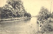
Miami and Erie Canal
Encyclopedia

Canal
Canals are man-made channels for water. There are two types of canal:#Waterways: navigable transportation canals used for carrying ships and boats shipping goods and conveying people, further subdivided into two kinds:...
that connected the Ohio River
Ohio River
The Ohio River is the largest tributary, by volume, of the Mississippi River. At the confluence, the Ohio is even bigger than the Mississippi and, thus, is hydrologically the main stream of the whole river system, including the Allegheny River further upstream...
in Cincinnati, Ohio
Ohio
Ohio is a Midwestern state in the United States. The 34th largest state by area in the U.S.,it is the 7th‑most populous with over 11.5 million residents, containing several major American cities and seven metropolitan areas with populations of 500,000 or more.The state's capital is Columbus...
with Lake Erie
Lake Erie
Lake Erie is the fourth largest lake of the five Great Lakes in North America, and the tenth largest globally. It is the southernmost, shallowest, and smallest by volume of the Great Lakes and therefore also has the shortest average water residence time. It is bounded on the north by the...
in Toledo, Ohio
Toledo, Ohio
Toledo is the fourth most populous city in the U.S. state of Ohio and is the county seat of Lucas County. Toledo is in northwest Ohio, on the western end of Lake Erie, and borders the State of Michigan...
. Construction on the canal began in 1825 and was completed in 1845. It consisted of 19 aqueduct
Aqueduct
An aqueduct is a water supply or navigable channel constructed to convey water. In modern engineering, the term is used for any system of pipes, ditches, canals, tunnels, and other structures used for this purpose....
s, three guard locks
Control lock
A control lock, or guard lock differs from a normal canal lock in that its primary purpose is controlling variances in water level rather than raising or lowering vessels. A control lock may also be known as a tide lock where it is used to control seawater entering into a body of fresh...
, and 103 canal locks. Each lock measured 90 feet (27.4 m) by 15 feet (4.6 m) and they collectively raised the canal 395 feet (120.4 m) above Lake Erie and 513 feet (156.4 m) above the Ohio River. The peak of the canal was called the Loramie Summit and extended 19 miles (30.6 km) between New Bremen, Ohio
New Bremen, Ohio
New Bremen is a village in Auglaize County, Ohio, United States. The population was 2,909 at of the 2000 census. It is included in the Wapakoneta, Ohio Micropolitan Statistical Area....
to lock 1-S in Lockington
Lockington Locks
The Lockington Locks are a group of canal locks on the former Miami and Erie Canal in Lockington, Ohio, United States. Built beginning in 1833, the locks opened for regular use in 1845. The system consists of seven locks: six together at one end, and a seventh at the southern end...
, north of Piqua, Ohio
Piqua, Ohio
Piqua is a city in Miami County, Ohio, United States. The population was 20,738 at the 2000 census. It is part of the Dayton Metropolitan Statistical Area.Piqua was one of the cities that experienced severe flooding during the Great Dayton Flood of 1913....
. The system consisted of 301.49 miles (485.2 km) of canal channel built at a cost of $8,062,680.07. Boats were towed along the canal using either donkey
Donkey
The donkey or ass, Equus africanus asinus, is a domesticated member of the Equidae or horse family. The wild ancestor of the donkey is the African Wild Ass, E...
s or horses walking on a prepared towpath
Towpath
A towpath is a road or trail on the bank of a river, canal, or other inland waterway. The purpose of a towpath is to allow a land vehicle, beasts of burden, or a team of human pullers to tow a boat, often a barge...
along the bank. The boats typically traveled at a rate of four to five miles per hour.
A topographical map showing the geography, path, and elevations of the entire canal can be found in the Heritage Museum, located in the building also housing the Shrine of the Holy Relics
Shrine of the Holy Relics
The Shrine of the Holy Relics in Maria Stein, Ohio is the second largest collection of relics in the United States. It is a part of the historic Maria Stein Convent.-History:...
, in Maria Stein, Ohio
Maria Stein, Ohio
Maria Stein is an unincorporated community in central Marion Township, Mercer County, Ohio, United States. The community and the Maria Stein Convent lie at the center of the area known as the Land of the Cross-Tipped Churches, where a missionary priest, Father Francis de Sales Brunner,...
, a community 6 mi (10 km) from the canal and just south of Grand Lake St. Marys
Grand Lake St. Marys
Grand Lake Saint Marys State Park is an Ohio state park, west of St. Marys, and south-east of Celina, south-west of Lima in the north-western part of the U.S. state of Ohio.Grand Lake covers in Mercer and Auglaize counties...
.
Grand Lake St. Marys
Grand Lake St. Marys
Grand Lake Saint Marys State Park is an Ohio state park, west of St. Marys, and south-east of Celina, south-west of Lima in the north-western part of the U.S. state of Ohio.Grand Lake covers in Mercer and Auglaize counties...
, an artificial lake west of St. Marys, Ohio
St. Marys, Ohio
St. Marys is a city in Auglaize County, Ohio, United States. The population was 8,342 at the 2000 census. It is included in the Wapakoneta, Ohio, Micropolitan Statistical Area.-History:...
was originally constructed as a reservoir to supply water for the canal. Lake Loramie in Shelby County
Shelby County, Ohio
As of the census of 2000, there were 47,910 people, 17,636 households, and 13,085 families residing in the county. The population density was 117 people per square mile . There were 18,682 housing units at an average density of 46 per square mile...
also was constructed as a reservoir for the canal. Indian Lake
Indian Lake (Ohio)
Indian Lake is a reservoir in Logan County, western Ohio, in the United States. It is approximately 20 mi southeast of Lima...
in Logan County
Logan County, Ohio
Logan County is a county in the state of Ohio, United States. As of the 2010 census, the population was 45,858. The county seat is Bellefontaine. The county is named for Benjamin Logan, who fought Native Americans in the area....
was greatly enlarged to provide a steadier supply of water for the Sidney feeder canal. All three lakes are still used for recreation.
Warren County Canal
The Warren County Canal was a branch of the Miami and Erie Canal in southwestern Ohio about in length that connected the Warren County seat of Lebanon to the main canal at Middletown in the mid-19th century. Lebanon was at the crossroads of two major roads, the highway from Cincinnati to Columbus...
, was constructed from the Miami and Erie Canal at Middletown, Ohio
Middletown, Ohio
Middletown is an All-America City located in Butler and Warren counties in the southwestern part of the U.S. state of Ohio. Formerly in Lemon, Turtlecreek, and Franklin townships, Middletown was incorporated by the Ohio General Assembly on February 11, 1833, and became a city in 1886...
to Lebanon, Ohio
Lebanon, Ohio
The population at the 2010 census was 20,033. As of the census of 2000, there were 16,962 people residing in the city. The population density was 1,440.6 people per square mile . There were 6,218 housing units at an average density of 528.1 per square mile...
. This branch was opened in 1840, but remained in operation less than 15 years before being abandoned.
A short branch, the Sidney
Sidney, Ohio
Sidney is a city in Shelby County, Ohio, United States. The population was 20,211 at the 2000 census. It is named after English poet Sir Phillip Sidney and is the county seat of Shelby County.Sidney was the recipient of the 1964 All-America City Award...
or Port Jefferson
Port Jefferson, Ohio
Port Jefferson is a village in Salem Township, Shelby County, Ohio, United States. The population was 321 at the 2000 census.-History:First known as Pratt, the village adopted its present name when it was incorporated on April 18, 1842. Port Jefferson was located where the Sidney feeder canal...
feeder canal ran up the Miami Valley from Lockington
Lockington, Ohio
Lockington is a village in Washington Township, Shelby County, Ohio, United States, along Loramie Creek. The population was 208 at the 2000 census....
through Sidney to a dam just upstream from Port Jefferson.
Much of the canal corridor remains a prosperous manufacturing area; today Interstate 75 and railroads provide transportation rather than the canal.
At Providence Metropark along the Maumee River near Grand Rapids, Ohio, there is a historical reenactment of the Miami-Erie canal. Historical actors dress and act as if it is 1876 during the months of May–October. Two mules pull the canal boat titled "The Volunteer" while workers till and provide commentary to the passengers. Providence Metroparks boasts using an original lock as part of the tour. That lock is the only working lock in the state of Ohio.
Construction standards
NOTE: Standards varied by region of the state. water depth. wide at water level. wide towpath in addition to mandated outer slopes.- All slopes are 4.5 ft (1.4 m) horizontal to 4 ft (1.2 m). perpendicular.
- The canal could accommodate boats up to 32 ft (9.8 m) long and 14 ft (4.3 m) wide.
Copies of the original survey plat maps for the construction of both Ohio canals are available on-line from the Ohio Department of Natural Resources.
Decline and abandonment
Rail transport
Rail transport is a means of conveyance of passengers and goods by way of wheeled vehicles running on rail tracks. In contrast to road transport, where vehicles merely run on a prepared surface, rail vehicles are also directionally guided by the tracks they run on...
in Ohio were built, the canal competed with railroads through much of its useful life. Ice in the winter, as well as the slowness of the boats, made it less efficient than railroads, especially for perishable goods and passenger traffic. The canal was a cheaper means for carrying bulk cargoes, such as grain and salted pork, though by 1906, the canal had largely ceased to operate. A catastrophic flood of the Great Miami River
Great Miami River
The Great Miami River is a tributary of the Ohio River, approximately long, in southwestern Ohio in the United States...
in 1913 and the subsequent flood control
Flood control
In communications, flood control is a feature of many communication protocols designed to prevent overwhelming of a destination receiver. Such controls can be implemented either in software or in hardware, and will often request that the message be resent after the receiver has finished...
measures constructed by the Miami Conservancy District
Miami Conservancy District
The Miami Conservancy District is a river management agency operating in Southwest Ohio to control flooding of the Great Miami River and its tributaries. It was organized in 1914 following the catastrophic Great Dayton Flood of the Great Miami River in March 1913, which hit Dayton, Ohio...
destroyed much of the canal infrastructure along the southern portion of the route where it paralleled the Great Miami River
Great Miami River
The Great Miami River is a tributary of the Ohio River, approximately long, in southwestern Ohio in the United States...
.
One of the original locks (#17) is located in the Carillon Historical Park
Carillon Historical Park
Carillon Historical Park is a 65-acre park and museum in Dayton, Ohio, which contains historic buildings and exhibits concerning the history of technology and the history of Dayton and its residents from 1796 to the present. The historical elements of the park were the brainchild of Colonel...
in Dayton, Ohio. An unrestored, but complete lock (#15) is located just off Main Street (State Route 571) in Tipp City. Remains of the Excello lock are still located in the Butler County
Butler County, Ohio
Butler County is a county located in the state of Ohio, United States. As of 2010, the population was 368,130. Its county seat is Hamilton. It is named for General Richard Butler, who died in 1791 fighting Indians in northern Ohio. Butler's army marched out of Fort Hamilton, where the city of...
Excello Locks Park near the intersection of State Route 73 and South Hamilton Middletown Road in Lemon Township
Lemon Township, Butler County, Ohio
Lemon Township is one of thirteen townships in Butler County, Ohio, United States. Located in the northeastern part of the county, it includes most of the city of Monroe and now exists as six disconnected pieces because of annexations by Monroe and Middletown...
.
Much of the original towpath served as the right-of-way
Right-of-way (railroad)
A right-of-way is a strip of land that is granted, through an easement or other mechanism, for transportation purposes, such as for a trail, driveway, rail line or highway. A right-of-way is reserved for the purposes of maintenance or expansion of existing services with the right-of-way...
for the Cincinnati and Lake Erie Railroad
Cincinnati and Lake Erie Railroad
The Cincinnati and Lake Erie Railroad was a short-lived electric interurban railway that operated in 1930-1939 Depression-era Ohio between Cincinnati, Springfield, Columbus, and Toledo...
, an electric interurban streetcar that operated until 1940. Part of the right-of-way was converted to the Wright-Lockland Highway (now part of Interstate 75
Interstate 75
Interstate 75 is a major north–south Interstate Highway in the Great Lakes and Southeastern regions of the United States. It travels from State Road 826 and State Road 924 in Hialeah, Florida to Sault Ste. Marie, Michigan, at the Ontario, Canada, border...
).
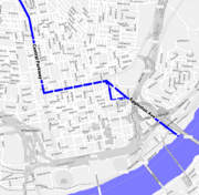
From 1920 to 1925, six million dollars was spent to use the bed of the canal to build a downtown subway in Cincinnati. The surface was later paved over to form Central Parkway as funds ran out before the Cincinnati Subway
Cincinnati Subway
The Cincinnati Subway is a set of unused tunnels and stations for a rapid transit system beneath the streets of Cincinnati, Ohio. It is recognized as the largest abandoned subway tunnel in the United States...
was completed.
Location
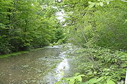
Urban redevelopment has eliminated the beginnings and ends of the canal. However, on the canal's southern end there is a drained section located in St. Bernard, OhioSt. Bernard, Ohio
St. Bernard is a small city in Hamilton County, Ohio, United States. The population was 4,924 at the 2000 census.-Geography:St. Bernard is located at , and along with Norwood and Elmwood Place, is an enclave surrounded by the city of Cincinnati.According to the United States Census Bureau, the...
's Ludlow Park where the canal bed is still visible. The canal remains in water (and navigable for canoes or kayaks) in the rural region between Delphos, Ohio
Delphos, Ohio
Delphos is a city in Allen and Van Wert Counties in the U.S. state of Ohio. It had a population of 6,944 at the 2000 census.The Allen County portion of Delphos is part of the Lima Metropolitan Statistical Area, while the Van Wert County portion is part of the Van Wert Micropolitan Statistical...
and St. Marys, Ohio
St. Marys, Ohio
St. Marys is a city in Auglaize County, Ohio, United States. The population was 8,342 at the 2000 census. It is included in the Wapakoneta, Ohio, Micropolitan Statistical Area.-History:...
. South of St. Mary's, it has degraded to form a shallow ditch in most places, with some ruined locks remaining. From north to south along State Route 66, one can see pieces of the original canal in Delphos, at a small historic park located at the "Deep Cut," in Spencerville
Spencerville, Ohio
Spencerville is a village in Allen County, Ohio, United States with a population of 2,235 as of the 2000 U.S. census. It is included in the Lima, Ohio Metropolitan Statistical Area.-Geography:Spencerville is located at ....
, Lock Two (a hamlet mostly consisting of period brick buildings), New Bremen
New Bremen, Ohio
New Bremen is a village in Auglaize County, Ohio, United States. The population was 2,909 at of the 2000 census. It is included in the Wapakoneta, Ohio Micropolitan Statistical Area....
, Minster
Minster, Ohio
Minster is a village in Auglaize County, Ohio, United States. The population was 2,794 at the 2000 census. It is included in the Wapakoneta, Ohio Micropolitan Statistical Area...
, Fort Loramie
Fort Loramie, Ohio
Fort Loramie is a village in Shelby County, Ohio, United States, along Loramie Creek. The population was 3,045 at the 2010 census. The village was founded in 1837.-History:...
, and Piqua
Piqua, Ohio
Piqua is a city in Miami County, Ohio, United States. The population was 20,738 at the 2000 census. It is part of the Dayton Metropolitan Statistical Area.Piqua was one of the cities that experienced severe flooding during the Great Dayton Flood of 1913....
. The Miami and Erie Canal Deep Cut
Miami and Erie Canal Deep Cut
The Miami and Erie Canal Deep Cut is a preserved, long, segment of the Miami and Erie Canal, United States. In order to avoid using locks to go over a ridge, the canal was dug deeply into the ridge, far more than the five-foot depth of the canal itself. Workers dug the canal bed up to fifty-two...
is a U.S. National Historic Landmark
National Historic Landmark
A National Historic Landmark is a building, site, structure, object, or district, that is officially recognized by the United States government for its historical significance...
near Spencerville that was designated in 1964. The Piqua Historical Area features a replica canal boat and other related items. The Delphos Canal Commission also has a canal museum located on Main Street.
In addition, visitors to Providence Metropark, near Grand Rapids in the northwest part of the state, are able to ride a replica canal boat as it goes through lock number 44. Lock 44 is an original Miami and Erie canal lock and Providence Metropark is the only place in Ohio in which visitors are able to travel completely through a functioning canal lock. Other sites of interest are listed.
The northern portion of the towpath (from Fort Loramie to Delphos and beyond) is used as a hiking trail. The massive west abutment of the Old Nine-mile Aqueduct over the Great Miami River is still present ca. 400 ft (121.9 m) upstream of the Taylorsville Dam east of Vandalia (Montgomery County). The aqueduct was destroyed by the Great 1913 Flood. The abutment terminates a fairly intact canal segment that extends at least 5 mi (8 km) north to Tipp City. This segment includes an intact concrete weir near the abandoned Vandalia water treatment plant (aka "Tadmore Station") and a ruined lock (#16, "Picayune") about halfway to Tipp City along Canal Road.
A 28 page visitor's guide booklet to the Miami & Erie Canal Heritage Corridor, including numbered tour map, stories, photos and descriptions of canal features, local attractions, museums, parks, and hiking trails is available online from the Ohio Department of Natural Resources. A map showing the disposition of the canal lands is available online from the Ohio Department of Natural Resources.
Cities and towns along the canal
The following is a list of towns and cities (arranged North to South) along the Miami and Erie Canal.- Toledo, OhioToledo, OhioToledo is the fourth most populous city in the U.S. state of Ohio and is the county seat of Lucas County. Toledo is in northwest Ohio, on the western end of Lake Erie, and borders the State of Michigan...
- Maumee, OhioMaumee, OhioMaumee is a city in Lucas County, Ohio, United States. It is a suburb of Toledo along the Maumee River. The population was 14,286 at the 2010 census. Maumee was also declared an All-America City by the National Civic League in June 2006.-Geography:...
- Waterville, OhioWaterville, OhioWaterville is a village in Lucas County, Ohio, United States, along the Maumee River. The population was 4,828 at the 2000 census.-Geography:Waterville is located at ....
- Providence, OhioProvidence, OhioProvidence is a ghost town on the Maumee River in southern Providence Township, Lucas County, Ohio, United States, about 24 miles southwest of Toledo.- History :...
- Texas, Ohio
- Napoleon, OhioNapoleon, OhioAs of the census of 2000, there were 9,318 people, 3,813 households, and 2,470 families residing in the city. The population density was 1,668.1 people per square mile . There were 4,066 housing units at an average density of 727.9 per square mile...
- Florida, OhioFlorida, OhioFlorida is a village in Henry County, Ohio, United States, along the Maumee River. The population was 246 at the 2000 census.-Geography:Florida is located at ....
- Defiance, OhioDefiance, OhioAs of the census of 2000, there were 16,465 people, 6,572 households, and 4,422 families residing in the city. The population density was 1,562.4 people per square mile . There were 7,061 housing units at an average density of 670.0 per square mile...
- Junction, OhioJunction, OhioJunction is an unincorporated community in western Auglaize Township, Paulding County, Ohio, United States. It lies along the concurrent State Routes 111 and 637. The Auglaize River flows along the eastern edge of the community...
- Melrose, OhioMelrose, OhioMelrose is a village in Paulding County, Ohio, United States. The population was 322 at the 2000 census.-Geography:Melrose is located at ....
- Ottoville, OhioOttoville, OhioOttoville is a village in Putnam County, Ohio, in the United States. As of the 2000 census, the village population was 873.-Geography:Ottoville is located at ....
- Delphos, OhioDelphos, OhioDelphos is a city in Allen and Van Wert Counties in the U.S. state of Ohio. It had a population of 6,944 at the 2000 census.The Allen County portion of Delphos is part of the Lima Metropolitan Statistical Area, while the Van Wert County portion is part of the Van Wert Micropolitan Statistical...
- Spencerville, OhioSpencerville, OhioSpencerville is a village in Allen County, Ohio, United States with a population of 2,235 as of the 2000 U.S. census. It is included in the Lima, Ohio Metropolitan Statistical Area.-Geography:Spencerville is located at ....
- St. Marys, OhioSt. Marys, OhioSt. Marys is a city in Auglaize County, Ohio, United States. The population was 8,342 at the 2000 census. It is included in the Wapakoneta, Ohio, Micropolitan Statistical Area.-History:...
- New Bremen, OhioNew Bremen, OhioNew Bremen is a village in Auglaize County, Ohio, United States. The population was 2,909 at of the 2000 census. It is included in the Wapakoneta, Ohio Micropolitan Statistical Area....
- Minster, OhioMinster, OhioMinster is a village in Auglaize County, Ohio, United States. The population was 2,794 at the 2000 census. It is included in the Wapakoneta, Ohio Micropolitan Statistical Area...
- Fort Loramie, OhioFort Loramie, OhioFort Loramie is a village in Shelby County, Ohio, United States, along Loramie Creek. The population was 3,045 at the 2010 census. The village was founded in 1837.-History:...
- Port Jefferson, OhioPort Jefferson, OhioPort Jefferson is a village in Salem Township, Shelby County, Ohio, United States. The population was 321 at the 2000 census.-History:First known as Pratt, the village adopted its present name when it was incorporated on April 18, 1842. Port Jefferson was located where the Sidney feeder canal...
(North end of the Sidney Feeder) - Sidney, OhioSidney, OhioSidney is a city in Shelby County, Ohio, United States. The population was 20,211 at the 2000 census. It is named after English poet Sir Phillip Sidney and is the county seat of Shelby County.Sidney was the recipient of the 1964 All-America City Award...
(Middle section of the feeder) - Lockington, OhioLockington, OhioLockington is a village in Washington Township, Shelby County, Ohio, United States, along Loramie Creek. The population was 208 at the 2000 census....
(Southern end junction of the Sidney Feeder) - Piqua, OhioPiqua, OhioPiqua is a city in Miami County, Ohio, United States. The population was 20,738 at the 2000 census. It is part of the Dayton Metropolitan Statistical Area.Piqua was one of the cities that experienced severe flooding during the Great Dayton Flood of 1913....
- Troy, OhioTroy, Ohio* - Sports :In addition to Troy High School athletics, Troy is home to the Miami Valley Silverbacks indoor football team of the Continental Indoor Football League....
- Tipp City, OhioTipp City, OhioTipp City is a city in Miami County, Ohio, United States. The population was 9,689 at the 2010 census. Formerly known as Tippecanoe, and then Tippecanoe City, this town was renamed to Tipp City in 1938 because another town in Ohio was likewise named Tippecanoe...
- Huber Heights, OhioHuber Heights, OhioHuber Heights is a city in Montgomery, Miami, and Greene Counties in the U.S. state of Ohio. Huber Heights's motto is "America's largest community of brick homes." The city is named for Charles Huber, the developer who constructed a number of the houses that would later comprise the city. Suburban...
- Dayton, OhioDayton, OhioDayton is the 6th largest city in the U.S. state of Ohio and the county seat of Montgomery County, the fifth most populous county in the state. The population was 141,527 at the 2010 census. The Dayton Metropolitan Statistical Area had a population of 841,502 in the 2010 census...
- Moraine, OhioMoraine, OhioMoraine is a city in Montgomery County, Ohio, United States. The population was 6,307 at the 2010 census. The city is part of the The Dayton Metropolitan Statistical Area, which includes Montgomery county. Moraine, as part of the Dayton area, is situated within the Miami Valley region of Ohio, just...
- Alexandersville, OhioAlexandersville, OhioAlexandersville, Ohio was a town located in Montgomery County, Ohio, United States just north of West Carrollton and south of Moraine. It was incorporated into West Carrollton prior to World War II....
- West Carrollton, OhioWest Carrollton, OhioWest Carrollton is a city in Montgomery County, Ohio, United States. The population was 13,143 at the 2010 census. It is part of the Dayton Metropolitan Statistical Area....
- Miamisburg, OhioMiamisburg, OhioMiamisburg is a city in Montgomery County, Ohio, United States. The population was 20,181 at the 2010 census. It is part of the Dayton Metropolitan Statistical Area...
- Franklin, OhioFranklin, OhioNot to be confused with Franklin County, Ohio.Franklin is a city in Warren County, Ohio, United States. The population was 11,771 at the 2010 census.-History:...
- Middletown, OhioMiddletown, OhioMiddletown is an All-America City located in Butler and Warren counties in the southwestern part of the U.S. state of Ohio. Formerly in Lemon, Turtlecreek, and Franklin townships, Middletown was incorporated by the Ohio General Assembly on February 11, 1833, and became a city in 1886...
- Sharonville, OhioSharonville, OhioSharonville is a city in Butler and Hamilton counties in the U.S. state of Ohio. The population was 13,804 at the 2000 census.-Geography:Sharonville is located at .It is part of the Cincinnati metropolitan area....
- Lockland, OhioLockland, OhioLockland is a village in Hamilton County, Ohio, United States. The population was 3,707 at the 2000 census. Lockland is located in southwest Ohio, north of Cincinnati...
(Site of the first set of locks) - St. Bernard, OhioSt. Bernard, OhioSt. Bernard is a small city in Hamilton County, Ohio, United States. The population was 4,924 at the 2000 census.-Geography:St. Bernard is located at , and along with Norwood and Elmwood Place, is an enclave surrounded by the city of Cincinnati.According to the United States Census Bureau, the...
- Cincinnati, OhioCincinnati, OhioCincinnati is a city in the U.S. state of Ohio. Cincinnati is the county seat of Hamilton County. Settled in 1788, the city is located to north of the Ohio River at the Ohio-Kentucky border, near Indiana. The population within city limits is 296,943 according to the 2010 census, making it Ohio's...
External links
- Map of canals in Ohio, the Miami and Erie Canal is on the left
- Miami-Erie Canal Corridor Association History of the canal and description of current efforts to preserve historical features
- Piqua Historical Society images of the Miami-Erie Canal
- Current photos of the Miami-Erie canal from Ohio Byways
- Piqua Historical Area includes a stretch of canal and a functional replica canal boat
- Map - Miami and Erie Canal through Cincinnati
- Plat maps of canal by county - ODNR
- Ohio Canals Map