

Metropolitan Adelaide Transport Study
Encyclopedia
Transport
Transport or transportation is the movement of people, cattle, animals and goods from one location to another. Modes of transport include air, rail, road, water, cable, pipeline, and space. The field can be divided into infrastructure, vehicles, and operations...
for the city of Adelaide
Adelaide
Adelaide is the capital city of South Australia and the fifth-largest city in Australia. Adelaide has an estimated population of more than 1.2 million...
.
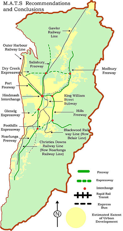
It recommended the construction of 98 kilometres of freeways, 34 kilometres of expressway
Limited-access road
A limited-access road known by various terms worldwide, including limited-access highway, dual-carriageway and expressway, is a highway or arterial road for high-speed traffic which has many or most characteristics of a controlled-access highway , including limited or no access to adjacent...
, the widening of 386 kilometres of existing arterial
Arterial road
An arterial road, or arterial thoroughfare, is a high-capacity urban road. The primary function of an arterial road is to deliver traffic from collector roads to freeways, and between urban centres at the highest level of service possible. As such, many arteries are limited-access roads, or feature...
roads, as well as new arterial roads, a new bridge over the Port River
Port River
The Port River is the western branch of the largest tidal estuary on the eastern side of Gulf St Vincent. It extends inland through the historic Inner Harbour of Port Adelaide, to the constructed salt-water West Lakes in the north-western suburbs of Adelaide, the capital of South Australia...
, 20 rail grade separation
Grade separation
Grade separation is the method of aligning a junction of two or more transport axes at different heights so that they will not disrupt the traffic flow on other transit routes when they cross each other. The composition of such transport axes does not have to be uniform; it can consist of a...
s and heavy rail improvements including a subway
Rapid transit
A rapid transit, underground, subway, elevated railway, metro or metropolitan railway system is an electric passenger railway in an urban area with a high capacity and frequency, and grade separation from other traffic. Rapid transit systems are typically located either in underground tunnels or on...
under King William Street
King William Street, Adelaide
King William Street is the part of a major arterial road that traverses the CBD and centre of Adelaide . It was named by the Street Naming Committee on 23 May 1837 after King William IV, the then reigning monarch, who died within a month...
.
The estimated cost of land acquisition and construction was $436.5 million dollars in 1968, which equates to approximately $4.58 billion in 2010 with inflation
Inflation
In economics, inflation is a rise in the general level of prices of goods and services in an economy over a period of time.When the general price level rises, each unit of currency buys fewer goods and services. Consequently, inflation also reflects an erosion in the purchasing power of money – a...
. Ultimately none of the plan's recommendations were brought to fruition in their original form, due to political and public opposition, in contrast to the 1969 Melbourne Transportation Plan
1969 Melbourne Transportation Plan
The 1969 Melbourne Transportation Plan was a road and rail transport plan for Melbourne, the state capital of Victoria, Australia instituted by Henry Bolte's state government...
.
In the time since the MATS plan was abandoned as a single transport package, analogous elements of the plan have been built or considered due to increasing transport pressures within greater Adelaide.
The Need For a Plan
Like other states, in South AustraliaSouth Australia
South Australia is a state of Australia in the southern central part of the country. It covers some of the most arid parts of the continent; with a total land area of , it is the fourth largest of Australia's six states and two territories.South Australia shares borders with all of the mainland...
there was a strong movement towards private car travel following the Second World War. Fuel rationing
Rationing
Rationing is the controlled distribution of scarce resources, goods, or services. Rationing controls the size of the ration, one's allotted portion of the resources being distributed on a particular day or at a particular time.- In economics :...
was a thing of the past and private car ownership was increasing. The car was seen as a personal liberator, allowing people to live and travel where they pleased.
Adelaide continued to expand rapidly due to people continuing to choose to live in suburbs as well as population growth and by 1966, Adelaide's population had increased by 90% on post war levels. Experts had been warning of the consequences of unplanned urban sprawl leading to a renewed interest in planning
Urban planning
Urban planning incorporates areas such as economics, design, ecology, sociology, geography, law, political science, and statistics to guide and ensure the orderly development of settlements and communities....
. In 1955 the Town Planning Act was amended to make a requirement for a coordinated plan to guide the future development of Adelaide in the best interest of the community.
The Report of Metropolitan Adelaide was released in 1962 and featured proposals for the construction of freeways, but lacked detail. Experts emphasized the urgent need for road improvement including freeways warning the longer the delay, the more costly and difficult the job would become. In 1964 the South Australian Premier Thomas Playford announced the commencement of a comprehensive planning study for the future of Adelaide's transport needs. This report, titled the Metropolitan Adelaide Transportation Study (MATS) was released in August, 1968 together with an announcement that six months would be allowed for public comment before commencement of work.
North-South Freeway
Elizabeth, South Australia
Elizabeth is a northern suburb of Adelaide, South Australia. It is located in the City of Playford.-History:Elizabeth was established in 1955 as part of a planned satellite town by the South Australian Housing Trust on rural land between the older towns of Salisbury and...
in the north to Sellicks Beach
Sellicks Beach, South Australia
Sellicks Beach is a town in South Australia, close to Aldinga, and representing the southernmost extent of the Adelaide urban conurbation. At the 2006 census, Sellicks Beach had a population of 1,622....
in the south, by the 1980s; an outcome some were keen on preventing.
Travel from Salisbury to Noarlunga would take approximately 30 minutes. The freeway consisted of two sections: the Noarlunga Freeway and the Salisbury Freeway. The Noarlunga freeway would serve the rapidly growing residential, industrial and recreational to the south connecting to major highways to Victor Harbour and Yankalilla.
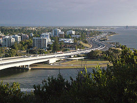
Starting at Old Noarlunga, it was to follow a path adjacent to Main South Road (this has since been completed and is known as the Southern Expressway
Southern Expressway
The Southern Expressway is the world's longest reversible one way freeway. Originally proposed as 'Noarlunga Freeway', it was built as a corridor to relieve heavy traffic from the major arterial, Main South Road, in Adelaide's south. The expressway was built in two stages — the first...
), then continuing north on a path roughly parallel to South Road then land near the west parkland with off ramps to the CBD, until joining the North Adelaide Connector. An interchange north of Anzac Highway would connect it to a proposed Glenelg Expressway along an abandoned railway corridor that still remains.
The Salisbury Freeway was the 6-lane continuation of the Noarlunga Freeway starting at the Hindmarsh Interchange then roughly followed the west of the Gawler rail line through Wingfield
Wingfield, South Australia
Wingfield is a suburb situated north of Adelaide and is located on Grand Junction Road. The suburb borders Gepps Cross and Dry Creek.- Government :The suburb of Wingfield is in the City of Port Adelaide Enfield local government area....
and north to Edinburgh
Edinburgh, South Australia
Edinburgh is a northern suburb of Adelaide, South Australia. It is an industrial suburb dominated by RAAF Base Edinburgh and DSTO Edinburgh.It was split from the suburb of Salisbury in 1997 when the Department of Defence decided to rationalise the then "DSTO Salisbury" site and sell off about 70%...
. The Noarlunga Freeway was to be 8 lanes, cost $34,000,000 in land acquisition, $58,000,000 in construction and carry 93,000 cars on an average weekday by 1986.
Main North Road
Main North Road
Main North Road is the major north-south arterial route north of the city of Adelaide, South Australia.From the Adelaide city centre, it passes through the Adelaide Parklands and the suburbs of Thorngate, Medindie, Medindie Gardens, Nailsworth, Prospect, Sefton Park, Blair Athol and Enfield before...
comparably carries approximately 46,000 cars on an average weekday in 2007. The Mitchell
Mitchell Freeway
Mitchell Freeway is a long freeway in Perth, Western Australia, linking Perth's central business district with its outer northern suburbs. It is allocated Route 2 for its entire length and is named after former state Premier and Governor Sir James Mitchell....
and Kwinana
Kwinana Freeway
The Kwinana Freeway is a major arterial road in Perth, Western Australia, linking Perth with the southern suburbs and then further on towards Mandurah, a distance of . It has a speed limit of , except in central Perth and south of Lakes Road . Like all Western Australian freeways, the minimum...
Freeways in Perth
Perth, Western Australia
Perth is the capital and largest city of the Australian state of Western Australia and the fourth most populous city in Australia. The Perth metropolitan area has an estimated population of almost 1,700,000....
forming a North-South Freeway present a good example as to what a North-South Freeway might have been like in Adelaide.
Port Freeway
This was to be a freeway constructed in the wide median strip of Port RoadPort Road, Adelaide
Port Road is a major road in Adelaide, South Australia connecting the central business district with Port Adelaide. It is 12 km long and exceptionally wide, approximately 70 m. When first conceived upon the establishment of Adelaide, it was designed to be able to accommodate a standard road, a...
that had been left in earlier years for a possible canal
Canal
Canals are man-made channels for water. There are two types of canal:#Waterways: navigable transportation canals used for carrying ships and boats shipping goods and conveying people, further subdivided into two kinds:...
leading from Port Adelaide
Port Adelaide
Port Adelaide is a suburb of Adelaide lying about 14 kilometres northwest of the City of Adelaide. It lies within the City of Port Adelaide Enfield and is the main port for the city of Adelaide...
to the Adelaide city centre. It was to go from the Hindmarsh Interchange to the Old Port Road intersection. It would feature pedestrian overpasses
Pedestrian separation structure
A pedestrian separation structure is any structure that removes pedestrians from a vehicle roadway. This creates a road junction where vehicles and pedestrians do not interact.This can be considered a type of grade separation structure on the road....
but was still criticised for blocking communications across Port Road. Following Port Road, Commercial Road was to continue over a new bridge
Bridge
A bridge is a structure built to span physical obstacles such as a body of water, valley, or road, for the purpose of providing passage over the obstacle...
over the Port River
Port River
The Port River is the western branch of the largest tidal estuary on the eastern side of Gulf St Vincent. It extends inland through the historic Inner Harbour of Port Adelaide, to the constructed salt-water West Lakes in the north-western suburbs of Adelaide, the capital of South Australia...
connecting to Victoria Road making a continuous arterial road
Arterial road
An arterial road, or arterial thoroughfare, is a high-capacity urban road. The primary function of an arterial road is to deliver traffic from collector roads to freeways, and between urban centres at the highest level of service possible. As such, many arteries are limited-access roads, or feature...
.
Hindmarsh Interchange
The largest construction project in the plan. The intersection of the Port Freeway, North-South Freeway and North Adelaide Connector would have required a four-level spaghetti interchange with many flyovers that would have almost engulfed the suburb of HindmarshHindmarsh, South Australia
Hindmarsh is an inner urban suburb of Adelaide, South Australia. It is located in the City of Charles Sturt.-History:The suburb is named after South Australia's first Governor, Sir John Hindmarsh....
. Pictures of similar sized interchanges
Interchange (road)
In the field of road transport, an interchange is a road junction that typically uses grade separation, and one or more ramps, to permit traffic on at least one highway to pass through the junction without directly crossing any other traffic stream. It differs from a standard intersection, at which...
in Los Angeles
Los Ángeles
Los Ángeles is the capital of the province of Biobío, in the commune of the same name, in Region VIII , in the center-south of Chile. It is located between the Laja and Biobío rivers. The population is 123,445 inhabitants...
were used to good effect by opponents of MATS. There were four different designs proposed including one that was to be sited in the parklands reducing the need for land acquisition.
North Adelaide Connector
This was to connect the West and Eastern sides of the city starting from the Hindmarsh Interchange and connecting to the Modbury Freeway. It would have encroached upon Parkland and go partway underground to reduce the loss of open space.Arterial road improvements have since taken place in the area, particularly on roads lining the parklands including Park Terrace, Fitzroy Terrace and Park Road. And overpass on Park Terrace over the Gawler railway line has been constructed but not over the Outer Harbor
Outer Harbor railway line, Adelaide
The Outer Harbor Railway Line in Adelaide, South Australia runs from Adelaide Railway Station. It includes many suburban railway stations, and shares part of its run with the Grange line.-History:...
railway line.
The Hawker Street tram bridge over the Gawler Railway line was demolished in the 1970s due to lack of maintenance and safety concerns. An overpass over the Gawler railway line
Gawler railway line, Adelaide
The Gawler Central line is a suburban commuter railway line in the city of Adelaide, South Australia. It is the only rail route in Adelaide to have no interchange with another line at any station except Adelaide.- History :...
at Torrens Road
Torrens Road, Adelaide
Torrens Road is an arterial road in the northwestern suburbs of Adelaide, Australia. The road travels in a southeast-northwest direction and is parallel with Port Road for most of its length. Major roads that intersect Torrens Road include South Road, Churchill Road and Regency Road...
has not been constructed as proposed but land set aside remains. A report on the Torrens Road
Torrens Road, Adelaide
Torrens Road is an arterial road in the northwestern suburbs of Adelaide, Australia. The road travels in a southeast-northwest direction and is parallel with Port Road for most of its length. Major roads that intersect Torrens Road include South Road, Churchill Road and Regency Road...
upgrade in 2005 stated grade separation was no longer a priority.
Hills Freeway
South Eastern Freeway
The South Eastern Freeway is a 66 kilometre four-lane divided carriageway road in South Australia linking the Adelaide-Crafers Highway to the Princes Highway at the Swanport Bridge, a one kilometre long bridge over the River Murray, near Murray Bridge...
(then under construction) and the CBD. It would have cut a swathe through College Park
College Park, South Australia
College Park is a suburb of Adelaide, South Australia in the City of Norwood Payneham St Peters. It has been ranked the most expensive suburb in South Australia, followed by Medindie.-References:...
, St. Peters
St. Peters, South Australia
St Peters is a suburb of Adelaide in the City of Norwood Payneham St Peters.The suburb was first settled in 1838, with allotments sold to investors in the South Australia Company. It was originally a separate town and was named after the Church of England's school of St Peter...
, Norwood
Norwood, South Australia
Norwood is a suburb of Adelaide, about 4 km east of the Adelaide city centre. The suburb is in the City of Norwood Payneham & St Peters, the oldest South Australian local government municipality, with a city population over 34,000.-History:...
, Rose Park
Rose Park, South Australia
Rose Park is a suburb with a population of 1,293 in the South Australian capital city of Adelaide. It is located one kilometre east of Adelaide's central business district . Rose Park is a leafy, tree-lined and wealthy inner suburb containing a number of historical and contemporary attractions...
, Myrtle Bank
Myrtle Bank, South Australia
Myrtle Bank is a suburb of Adelaide, South Australia in the City of Unley. The suburb is named after a property near the foothills built in 1842 by William Sanders , who arrived in South Australia in 1838. He named the premises 'Myrtle Bank', because his friend James Gall of Trinity living in...
and Urrbrae
Urrbrae, South Australia
Urrbrae is a suburb of Adelaide, South Australia. It is located in the City of Mitcham.Located at the foot of the Adelaide Hills, it is bordered on the east by the South Eastern Freeway, and the Old Toll House, which marked the traditional entrance to the city of Adelaide in the 19th...
before leaving the city at Belair Road. Many of Adelaide's most affluent suburbs would have been broken up. This proved to be the most controversial part of the entire MATS plan. It was dropped from subsequent proposals but served to turn public opinion against the rest of the project.
Foothills Expressway
A proposed link between the North-South Freeway at DarlingtonDarlington, South Australia
Darlington is a suburb of Adelaide, South Australia part of which is in the City of Onkaparinga and the City of Marion.-References:...
(approximately the point where South Road meets Sturt Road) travelling in a north-east direction to meet up with the Hills Freeway at Belair Road. The expressway was scrapped from subsequent proposals with the Hills Freeway.
Modbury Freeway
Starting at the North Adelaide Connector, this would have followed the River TorrensRiver Torrens
The River Torrens is the most significant river of the Adelaide Plains and was one of the reasons for the siting of the city of Adelaide, capital of South Australia. It flows from its source in the Adelaide Hills near Mount Pleasant, across the Adelaide Plains, past the city centre and empties...
along Linear Park (the O-Bahn Busway
O-Bahn Busway
The Adelaide O-Bahn Busway is a guided busway located in Adelaide, South Australia. The O-Bahn – from the Latin omnibus and the German bahn – was conceived by Daimler-Benz to enable buses to avoid traffic congestion by sharing tram tunnels in the German city of Essen.The route was introduced in...
was later constructed on this corridor instead). At approximately 1 km from the O-Bahn's current terminus, Modbury
Modbury, South Australia
Modbury is a suburb of Adelaide, South Australia in the City of Tea Tree Gully. Modbury is located at the end of the Adelaide O-Bahn and is home to the Tea Tree Plaza shopping complex and a Hospital.It was named Modbury by R...
, it would have then turned further north along what is now McIntyre Road through Golden Grove
Golden Grove, South Australia
Golden Grove is an outer north-eastern suburb of Adelaide, South Australia and is within the City of Tea Tree Gully local government area. It is adjacent to Wynn Vale, Surrey Downs, Greenwith, Yatala Vale, Fairview Park, and Salisbury East.- History :...
.
An express bus
Express bus
An express bus service is a bus service that is intended to run faster than normal bus services between the same two commuter points....
service along the freeway giving a similar service to the current O-Bahn was proposed. The freeway would have required the relocation of the River Torrens
River Torrens
The River Torrens is the most significant river of the Adelaide Plains and was one of the reasons for the siting of the city of Adelaide, capital of South Australia. It flows from its source in the Adelaide Hills near Mount Pleasant, across the Adelaide Plains, past the city centre and empties...
in various sections; though it was stated consideration would be given to maintain the beauty of the river.
Dry Creek Expressway
Starting at Port Adelaide, this would have been an east-west connector running roughly parallel to and slightly north of Grand Junction RoadGrand Junction Road, Adelaide
Grand Junction Road is the longest east-west thoroughfare in the Adelaide metropolitan area, and is located approximately 9 kilometres north of the city centre. Travelling from the Port Adelaide region, it is mostly a double lane sealed road running 21 kilometres to the base of the Adelaide Hills...
and terminating at the Modbury Freeway. The section west of Main North Road
Main North Road
Main North Road is the major north-south arterial route north of the city of Adelaide, South Australia.From the Adelaide city centre, it passes through the Adelaide Parklands and the suburbs of Thorngate, Medindie, Medindie Gardens, Nailsworth, Prospect, Sefton Park, Blair Athol and Enfield before...
has been completed since as the Port River Expressway
Port River Expressway
The Port River Expressway is a freeway-grade road. The expressway links Port Adelaide and the LeFevre Peninsula to the northern suburbs of Adelaide and major interstate routes via Salisbury Highway to Port Wakefield Road and the Northern Expressway to Perth and Sydney.The expressway is only...
. However it has not been extended eastward.
| Noarlunga Freeway | Hindmarsh Interchange | North Adelaide Connector | Port Freeway | Salisbury Freeway | Hills Freeway | Modbury Freeway | |
|---|---|---|---|---|---|---|---|
| Cost Land Acquisition | 34,000,000 | 16,700,000 | 5,700,000 | 100,000 | 9,800,000 | 20,000,000 | 7,400,000 |
| Cost Construction | 58,000,000 | 13,000,000 | 11,500,000 | 15,100,000 | 14,000,000 | 32,000,000 | 42,500,000 |
| Cost Total | 92,000,000 | 29,700,000 | 17,200,000 | 15,200,000 | 23,800,000 | 52,000,000 | 49,900,000 |
| Estimated Cars Weekday 1986 | 93,000 | N/A | 62,000 | 68,000 | 62,000 | 58,500 | 79,000 |
| Length in Kilometres | 34.4 | 2.6 | 3.2 | 3.3 | 12.7 | 2.9 | 21.2 |
| Number of Lanes | 8 | N/A | 6 | 6 | 6 | 6 | 8 |
Public Transport Changes
There were various changes to public transport proposed. Public Transport was said to be important in directing and shaping urban growth which included increasing vitality of the city centreCentral business district
A central business district is the commercial and often geographic heart of a city. In North America this part of a city is commonly referred to as "downtown" or "city center"...
. It would provide support for those in the community that could not drive.
The rail system was to be turned into a rapid rail network which would be aimed at providing efficient long distance, high speed suburban transport. Many existing train station
Train station
A train station, also called a railroad station or railway station and often shortened to just station,"Station" is commonly understood to mean "train station" unless otherwise qualified. This is evident from dictionary entries e.g...
s were to be closed and some to be relocated to link to main roads. Closure of stations allowed higher running speeds of trains and reduced running and maintenance costs.
Locating stations closer to main roads made them more accessible and visible. Train Stations would be supported by feeder bus services increasing the serviceable range of stations. Competing bus services were to be removed. A space of 3.2 kilometres between railway stations was said to be optimal.
The Noarlunga train line, which then only went to Hallett Cove, was to be extended to Christie Downs
Christie Downs, South Australia
Christie Downs is a suburb in southern Metropolitan Adelaide within the City of Onkaparinga, South Australia. It has a unique postcode of 5164, and is adjacent to the suburbs of Christies Beach to the west, Noarlunga Centre to the south, Morphett Vale to the east and Lonsdale to the north.The area...
. The Glenelg Tram
Glenelg Tram
The Glenelg Tram is a route from the centre of Adelaide, South Australia to the beach-side suburb of Glenelg. It is Adelaide's only remaining tramway, running at approximately 15-minute intervals, and is part of the integrated Adelaide Metro public transport network...
line would require additional investment to integrate with the proposed new rapid rail system
Rapid transit
A rapid transit, underground, subway, elevated railway, metro or metropolitan railway system is an electric passenger railway in an urban area with a high capacity and frequency, and grade separation from other traffic. Rapid transit systems are typically located either in underground tunnels or on...
, and construct grade separation
Grade separation
Grade separation is the method of aligning a junction of two or more transport axes at different heights so that they will not disrupt the traffic flow on other transit routes when they cross each other. The composition of such transport axes does not have to be uniform; it can consist of a...
s along existing roads.
However its patronage was lower than competing bus routes along parallel Anzac Highway
Anzac Highway, Adelaide
The Anzac Highway is an 11 kilometre main arterial road heading southwest from the city of Adelaide, the capital of South Australia, to the beachside suburb of Glenelg....
. It was said to not be cost effective to maintain the tramline. It was predicted accurately that overall public transport usage would fall to below 5% by around the year 2000, and proceeding with the recommended changes would maintain the number at 7%.
King William Street Subway
The most significant Public Transport change was a rail subway starting from the railway where the current train station is under King William Street and exiting where the current Glenelg TramGlenelg Tram
The Glenelg Tram is a route from the centre of Adelaide, South Australia to the beach-side suburb of Glenelg. It is Adelaide's only remaining tramway, running at approximately 15-minute intervals, and is part of the integrated Adelaide Metro public transport network...
leaves South Terrace. It was said the subway would lead to increased land values and encourage development to the south side of the city; the Toronto Yonge Street
Yonge Street
Yonge Street is a major arterial route connecting the shores of Lake Ontario in Toronto to Lake Simcoe, a gateway to the Upper Great Lakes. It was formerly listed in the Guinness Book of Records as the longest street in the world at , and the construction of Yonge Street is designated an "Event of...
Subway was used as an example. It would have been necessary to abandon Adelaide Railway Station
Adelaide Railway Station
Adelaide Railway Station is the central terminus of the Adelaide Metro railway system. It is at on the north side of North Terrace, west of Parliament House. The Adelaide Casino is in part of the building that is no longer required for the station....
for the subway, which would have made land around the station available for redevelopment.
The plan for the subway contained three stations throughout the city and was estimated to cost $32,000,000. A cut and cover construction technique was to be used reducing construction costs. Such a method would be unviable now due to development that has taken place since.
Reaction and Opposition
MATS became politicised as initial public reaction became a party stance. South Australians in general were opposed to freeways for various reasons. Opposition was similar to the Freeway and expressway revoltsFreeway and expressway revolts
Many freeway revolts took place in developed countries during the 1960s and 1970s, in response to plans for the construction of new freeways, a significant number of which were abandoned or significantly scaled back due to widespread public opposition; especially of those whose neighborhoods would...
experienced in the United States. Large scale property acquisition proved to be one of the largest sources of opposition. The Noarlunga Freeway alone would have required the acquisition as many as 3,000 properties, including 817 residential dwellings. The Hills Freeway would have required the demolition of significant areas of the historic suburbs of inner south-eastern Adelaide.
The impact of freeways on the urban landscape also proved to be a large source of opposition. It was feared freeways would create urban problems. People looked at cities such as the city of Los Angeles
Los Ángeles
Los Ángeles is the capital of the province of Biobío, in the commune of the same name, in Region VIII , in the center-south of Chile. It is located between the Laja and Biobío rivers. The population is 123,445 inhabitants...
and the urban problems it experienced such as gridlock
Gridlock
The term gridlock is defined as "A state of severe road congestion arising when continuous queues of vehicles block an entire network of intersecting streets, bringing traffic in all directions to a complete standstill; a traffic jam of this kind." The term originates from a situation possible in...
ed traffic and the division of neighbourhoods leading to the creation of urban ghettos and believed the same would happen in Adelaide if freeways were constructed. The Report on the Metropolitan Area of Adelaide 1962 contained images of the city of Los Angeles and its extensive freeways to represent a potential model for Adelaide's future transport solutions.
Many believe these problems would not be created by the construction of freeways, and comparing the construction of freeways in Adelaide with the city of Los Angeles was a misrepresentation of the realities. It is unlikely the construction of freeways would have led to urban problems experienced in large cities such as Los Angeles and more appropriate comparisons to cities of a similar size to Adelaide such as Calgary
Calgary
Calgary is a city in the Province of Alberta, Canada. It is located in the south of the province, in an area of foothills and prairie, approximately east of the front ranges of the Canadian Rockies...
, Canada were not used.
Some wanted Adelaide to develop as a more European type city with high density housing and a stronger emphasis on public transport. The superintending engineer of the Highways Department attacked more extreme positions on public transport stating that it had been planned to the maximum extent that is economically feasible. He stated there was no shortfall of “instant experts” in the community who saw public transport as a solution to all urban problems, but being too long on imagination and too short on practicality.
Result of MATS
In 1969 the State Cabinet with Liberal and Country LeagueLiberal and Country League
The Liberal and Country League was a major political party in South Australia throughout its forty year existence. Thirty-four years were spent in government, in part due to the electoral malapportionment known as the Playmander, introduced after coming to power.Created on 9 June 1932 as the...
coalition as government and Steele Hall
Steele Hall
Raymond Steele Hall was the 36th Premier of South Australia 1968-70, a senator for South Australia 1974-77, and federal member for the Division of Boothby 1981-96.-Biography:...
as premier approved the MATS Plan excluding some proposals which were to be further reviewed including:
- Closure of the Grange Railway line
- Foothills Expressway and Hills Freeway
- Selections of the Modbury, Noarlunga Freeways and Dry Creek Expressway
- Rerouting railway from EdwardstownEdwardstown, South AustraliaEdwardstown is an inner Southern suburb located 6 km southwest of Adelaide in the City of Marion.Edwardstown is in the South Australian House of Assembly Electoral district of Elder and the Australian House of Representatives Division of Hindmarsh. Edwardstown is home to the Castle Plaza Shopping...
to GoodwoodGoodwood, South AustraliaGoodwood is an inner southern suburb of the city of Adelaide. It neighbours the Royal Adelaide Showgrounds and features several churches in its commercial district...
Abandonment
In 1970 a new LaborAustralian Labor Party
The Australian Labor Party is an Australian political party. It has been the governing party of the Commonwealth of Australia since the 2007 federal election. Julia Gillard is the party's federal parliamentary leader and Prime Minister of Australia...
government under Don Dunstan
Don Dunstan
Donald Allan "Don" Dunstan, AC, QC was a South Australian politician. He entered politics as the Member for Norwood in 1953, became state Labor leader in 1967, and was Premier of South Australia between June 1967 and April 1968, and again between June 1970 and February 1979.The son of a business...
was elected and shelved MATS, but did not go as far as selling the corridors already acquired in case opinion changed in the future. Dunstan proposed satellite cities such as Monarto, as well as investigating new technologies in public urban transport
Public transport
Public transport is a shared passenger transportation service which is available for use by the general public, as distinct from modes such as taxicab, car pooling or hired buses which are not shared by strangers without private arrangement.Public transport modes include buses, trolleybuses, trams...
. Dunstan attempted to construct a light rail line in the north-east along the Modbury corridor. It later turned out the O-Bahn
O-Bahn Busway
The Adelaide O-Bahn Busway is a guided busway located in Adelaide, South Australia. The O-Bahn – from the Latin omnibus and the German bahn – was conceived by Daimler-Benz to enable buses to avoid traffic congestion by sharing tram tunnels in the German city of Essen.The route was introduced in...
would be constructed instead.
In 1980, the Liberal party
Liberal Party of Australia
The Liberal Party of Australia is an Australian political party.Founded a year after the 1943 federal election to replace the United Australia Party, the centre-right Liberal Party typically competes with the centre-left Australian Labor Party for political office...
won government on a platform of fiscal conservatism
Fiscal conservatism
Fiscal conservatism is a political term used to describe a fiscal policy that advocates avoiding deficit spending. Fiscal conservatives often consider reduction of overall government spending and national debt as well as ensuring balanced budget of paramount importance...
and the premier David Tonkin
David Tonkin
Dr David Oliver Tonkin AO was the 38th Premier of South Australia, serving from 18 September 1979 to 10 November 1982. He was elected to the House of Assembly seat of Bragg at the 1970 election, serving until 1983. He became the leader of the South Australian division of the Liberal Party of...
committed his government to selling off the land acquired for the MATS plan ensuring that even when needs or public opinion
Public opinion
Public opinion is the aggregate of individual attitudes or beliefs held by the adult population. Public opinion can also be defined as the complex collection of opinions of many different people and the sum of all their views....
changed, the construction of most MATS-proposed freeways would be impossible. However debate continued on a North-South Freeway to replace South Road
South Road, Adelaide
South Road is a major north–south conduit in Adelaide, South Australia. Also known as Main South Road, it is Adelaide's most important arterial road.- Route :...
. In 1982, the Minister for Transport Michael Wilson
Michael Wilson (Australian politician)
Michael Minell Wilson is a former South Australian politician and MP in the House of Assembly from 1977 to 1985, representing the Electoral district of Torrens. He oversaw the construction of the Adelaide O-Bahn Busway whilst in office as Transport Minister.-References:...
, abandoned the idea of a high speed freeway and instead began widening South Road between Torrens Road
Torrens Road, Adelaide
Torrens Road is an arterial road in the northwestern suburbs of Adelaide, Australia. The road travels in a southeast-northwest direction and is parallel with Port Road for most of its length. Major roads that intersect Torrens Road include South Road, Churchill Road and Regency Road...
and Daws Road
Daws Road, Adelaide
Daws Road is a major double lane arterial road in the central southern suburbs of Adelaide, running east-west between Goodwood Road in the east and Marion Road in the west. Daws Road crosses South Road and the Tonsley railway line. It passes under one of the two diagonal railway bridges of the...
as a short term solution while retaining a corridor from Dry Creek
Dry Creek, South Australia
Dry Creek is a mostly industrial suburb located north of Adelaide, containing significant wetlands and a substantial area devoted to salt crystallization pans, managed by Cheltenham Salt Limited....
to Darlington
Darlington, South Australia
Darlington is a suburb of Adelaide, South Australia part of which is in the City of Onkaparinga and the City of Marion.-References:...
as a concept.
In June 1983, the North-South Corridor, the last surviving element of MATS, was completely abandoned as too much land had been sold off to make it practical. The abandonment had a significant impact on the Highways Department as it was the first time in its history that a government had rejected the recommendations of the Commissioner. It undermined the Department's record of independence from politics. Some of the city's current transport bottleneck
Bottleneck
A bottleneck is a phenomenon where the performance or capacity of an entire system is limited by a single or limited number of components or resources. The term bottleneck is taken from the 'assets are water' metaphor. As water is poured out of a bottle, the rate of outflow is limited by the width...
s would have been reduced had the originally proposed freeways been constructed.
Post-abandonment assessment
Attitudes towards MATS in the present day are mixed. The then premier Steele Hall still believed abandoning the plan was a severe mistake and has received mention in The Advertiser about the topic in recent times.MP Bob Such
Bob Such
Robert Bruce "Bob" Such , Australian politician, is the member for the seat of Fisher in the South Australian House of Assembly, as an independent since 2000, and as member of the Liberal Party member from the 1989 election to 2000....
praised the efficiency of the South-Eastern Freeway, and he stated in parliament, "I found it quicker to get from Murray Bridge to my home at Coromandel Valley (~60km) than to get from my home to the city (~18km). That is an indication of the effectiveness of the freeway."
Those in support for public transport
Public transport
Public transport is a shared passenger transportation service which is available for use by the general public, as distinct from modes such as taxicab, car pooling or hired buses which are not shared by strangers without private arrangement.Public transport modes include buses, trolleybuses, trams...
reject the plan as it is perceived it would create competition against public transport usage, and lead to urban sprawl.
Others believe varying degrees of the plan were too ruthless towards the environment and would have ruined the character of Adelaide. Some of the issues raised about the construction of freeways can now be seen to have been unlikely to have eventuated. For example, Adelaide has spread north and south instead of the inner areas becoming denser despite a lack of freeways.
Construction and motoring lobbies generally favoured the plan heavily and, periodically, refer to the rejection of the MATS plan as a lost opportunity. Major road lobby groups as of 2007 continue to call for a North-South freeway in particular with the State Government joining calls for funding under the Federal Government's AusLink
AusLink
AusLink was an Australian Government land transport funding program, established in June 2004 and administered by the Department of Transport and Regional Services. In 2009 it was replaced with the Nation Building Program under the Nation Building Program Act 2009...
Program.
MATS since
Some roads constructed since MATS are reminiscent of the original proposed freeways in MATS due to Adelaide's inherent transport pressures. The Southern ExpresswaySouthern Expressway
The Southern Expressway is the world's longest reversible one way freeway. Originally proposed as 'Noarlunga Freeway', it was built as a corridor to relieve heavy traffic from the major arterial, Main South Road, in Adelaide's south. The expressway was built in two stages — the first...
has been constructed partly following the alignment the southern section of the Noarlunga freeway. It remained viable to construct as much land remained undeveloped. The South Eastern Freeway, was completed in 1979 and had partly began construction at the time of MATS. The Port River Expressway
Port River Expressway
The Port River Expressway is a freeway-grade road. The expressway links Port Adelaide and the LeFevre Peninsula to the northern suburbs of Adelaide and major interstate routes via Salisbury Highway to Port Wakefield Road and the Northern Expressway to Perth and Sydney.The expressway is only...
was opened in 2005, which partially follows the original Modbury
Modbury, South Australia
Modbury is a suburb of Adelaide, South Australia in the City of Tea Tree Gully. Modbury is located at the end of the Adelaide O-Bahn and is home to the Tea Tree Plaza shopping complex and a Hospital.It was named Modbury by R...
to Port Adelaide ("Dry Creek") Expressway proposed by MATS but does not extend eastwards.
The Rann government stated it believes South Road should be upgraded into a non stop north-south route, but declined a 2007 $1bn pre-election funding offer from the then Howard Government, whch would have upgraded substantial sections of the road. Construction of an underpass at the intersection of South Road and Anzac highway begun in 2007 and was completed in 2009, however another proposed underpass under the intersections of Grange Road, Port Road
Port Road, Adelaide
Port Road is a major road in Adelaide, South Australia connecting the central business district with Port Adelaide. It is 12 km long and exceptionally wide, approximately 70 m. When first conceived upon the establishment of Adelaide, it was designed to be able to accommodate a standard road, a...
and the Outer Harbor
Outer Harbor railway line, Adelaide
The Outer Harbor Railway Line in Adelaide, South Australia runs from Adelaide Railway Station. It includes many suburban railway stations, and shares part of its run with the Grange line.-History:...
/Grange railway line
Grange railway line, Adelaide
The Grange railway line is a suburban branch line in the city of Adelaide, South Australia.-History:The railway line between Woodville and Grange opened in September 1882. This was a private railway, constructed by the Grange Railway and Investment Company...
appears to has been shelved, possibly due to the substantial cost blowouts of the South Road/Anzac Highway underpass.
The same government proposes another underpass be built at the South Rd/Sturt intersection after 2010. Construction of roads has become considerably more expensive than at the time of the MATS proposal due to increasing construction and land costs. The South Road project is due to be completed by 2020.
See also
- Transport in AdelaideTransport in AdelaideThe city of Adelaide, South Australia is served by a wide variety of transport, being centrally located on the Australian mainland and forms a hub for east-west and north-south routes. The road network includes the Southern Expressway, a reversible one way freeway...
- State Transport AuthorityState Transport Authority (South Australia)The State Transport Authority was the government agency which controlled public transport within the State of South Australia between 1974 and 1994....
- Railways in AdelaideRailways in AdelaideThe rail network in Adelaide, South Australia, consists of five lines and 81 stations, totalling 125.9 km. It is operated by Adelaide Metro, and is part of the city-wide Adelaide Metro]public transport system. Apart from the Glenelg Tram, Adelaide's railway system is serviced entirely by...
- Freeways in AustraliaFreeways in AustraliaThis is a list of freeways and motorways in Australia, sorted by states and territories and their corresponding routes. This list includes toll roads such as the CityLink freeway system in Melbourne. This list has over 70 entries...
- South Eastern FreewaySouth Eastern FreewayThe South Eastern Freeway is a 66 kilometre four-lane divided carriageway road in South Australia linking the Adelaide-Crafers Highway to the Princes Highway at the Swanport Bridge, a one kilometre long bridge over the River Murray, near Murray Bridge...
- South RoadSouth Road, AdelaideSouth Road is a major north–south conduit in Adelaide, South Australia. Also known as Main South Road, it is Adelaide's most important arterial road.- Route :...
- History of AdelaideHistory of AdelaideThis article details the History of Adelaide from the first human activity in the region to the 20th century. Adelaide is a planned city founded in 1836 and the capital of South Australia.-Aboriginal settlement:...
Melbourne:
- 1969 Melbourne Transportation Plan1969 Melbourne Transportation PlanThe 1969 Melbourne Transportation Plan was a road and rail transport plan for Melbourne, the state capital of Victoria, Australia instituted by Henry Bolte's state government...
Hobart:
- Hobart Area Transportation StudyHobart Area Transportation StudyThe Hobart Area Transportation Study was a comprehensive transport plan released in 1965 for the purpose of examining the transport needs of the Hobart Metropolitan area over the proceeding 20 years...