

Metro La Paz
Encyclopedia
Metro La Paz is located on the west side of Bolivia
, with the population of more than 2.3 million inhabitants joining the cities of La Paz
, El Alto
,and Viacha
, making it the most populous urban area of Bolivia, on the altitude of 4,000 it makes it the highest metropolitan city on the world.
a Spanish governor of Peru who was said by the Spanish king (and Holy Roman Emperor) Emperor Charles V
to found a new city. Gasca commanded captain Alonso de Mendoza
to found a new city commemorating the end of the civil wars in Peru; the city of La Paz was founded on October 20, 1548.
Founded in 1548 by the Spanish
conquistador
s at the site of the Native American settlement of Laja
, the full name was originally Nuestra Señora de La Paz (meaning Our Lady of Peace
). The name commemorated the restoration of peace after having a civil war between Gonzalo Pizarro
and Blasco Núñez Vela
the first viceroy
of Peru
. The city was later moved to its present location in the valley of Chuquiago Marka in where the metropilitan area begun.
In 1549, Juan Gutierrez Paniagua was ordered to design an urban plan that would designate sites for public areas, plazas, official buildings, and a cathedral. "La Plaza de los Españoles", which is known today as the Plaza Murillo, was chosen as the location for government buildings as well as the Metropolitan Cathedral.
After the city was built Spain controlled La Paz with a firm grip and the Spanish king had the last word in all matters political. In 1781, for a total of six months, a group of Aymara people laid siege to the no longer peaceful city of La Paz. Under the leadership of Tupac Katari
, they destroyed churches and government property. Thirty years later Indians laid a two-month siege on La Paz - where and when the legend of the Ekeko
is set. In 1809 the struggle for independence from the Spanish rule brought uprisings against the royalist forces. It was on July 16, 1809 that Pedro Domingo Murillo famously said that the Bolivian revolution was igniting a lamp that nobody would be able to turn-off. This formally marked the beginning of the Liberation of South America from Spain
. Pedro Domingo Murillo was hanged at the Plaza de los Españoles that night, but his name would be eternally remembered in the name of the plaza forever, and he would be remembered as the voice of revolution across South America.
In 1825 after the independence of Bolivia, the city's full name was changed to La Paz de Ayacucho (meaning The Peace of Ayacucho) in commemoration of the decisive victory over the Spanish army at Battle of Ayacucho
in the course of the Spanish American wars of independence.
In 1898, La Paz was made the de facto
seat of the national government, with Sucre
remaining the nominal historical as well as judiciary capital. This change reflected the shift of the Bolivian economy away from the largely exhausted silver
mines
of Potosí
to the exploitation of tin
near Oruro
, and resulting shifts in the distribution of economic and political power among various national elite
s.
When the new built railways from Lake Titicaca
and Arica
reached the rim of the canyon, where the La Paz terminus, railyards and depots were built along with a settlement of railway workers (a spur line down into the canyon opened in 1905). In 1925 the airfield was built as base for the new air force, which attracted additional settlement. In 1939 El Alto's first elementary school opened. El Alto started to grow tremendously in the 1950s, when the settlement was connected to La Paz' water supply (before that all water had to be transported from La Paz in tank vehicles) and building land in the canyon became more and more short and expensive. In an administrative reform on March 6, 1985 the district of El Alto and surroundings was politically separated from the City of La Paz (this date is officially referred to and celebrated as the city's "founding day"). In 1987 El Alto was formally incorporated
as a city. In 1994, the city became the seat of the Roman Catholic Diocese of El Alto
.
From 2003 to 2005, access from La Paz to the International Airport, as well to oil and gas supplies, were frequently blocked by protesting El Alto social leaders, who have become some of the most powerful players in the politics of Bolivia
. El Alto was - and remains - one of the major centers of the Bolivian gas conflict, during the conflict 70 civilians were killed under police repression ordered by President Gonzalo Sánchez de Lozada
.
The geography of La Paz (in particular the altitude) reflects society: the lower areas of the city are the more affluent areas. While many middle-class residents live in high-rise condos near the center, the houses of the truly affluent are located in the lower neighborhoods southwest of the Prado. And looking up from the center, the surrounding hills are plastered with makeshift brick houses of those of less economic fortune.
The satellite city of El Alto, in which the airport is located, is spread over a broad area to the west of the canyon, on the Altiplano
.
La Paz is renowned for its unique markets, very unusual topography, and traditional culture.
Under the Koppen climate classification
, La Paz has a Subtropical highland climate
. Owing to the altitude of the city, temperatures are consistently cool throughout the year, though the diurnal temperature variation
is typically large. The city has a relatively dry climate, with rainfall occurring mainly in the slightly warmer months of November to March. The sun passes directly overhead in late October and mid February.
La Paz is located in the valleys of the Andes, and is closer to the Eastern split of the Altiplano region. Therefore, it is closer to the famous mountains such as the Illimani (guardian of La Paz), Huayna Potosi, Mururata, and Illampu. On the Western side of the Altiplano divide, about an hour to the West of the La Paz, is the site of the tallest mountain in Bolivia and 9th tallest mountain in the Andes, the Sajama Volcano. In July 1994, an earthquake rated at 8.2 struck just 200 miles north of La Paz, the largest earthquake since the Sumbawa earthquake of 1977. Part of the water supply is derived from glacier, which are becoming a less reliable source of water.
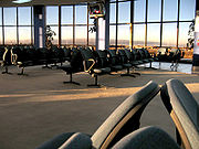 La Paz is served by El Alto International Airport
(IATA code: LPB), which is situated eight miles (14 km) south-west of La Paz. At an elevation
of 4061 metres (13,323 ft), it is one of the highest major airports in the world. Airport facilities include a bank, bars, car rentals, restaurants, and duty-free shops. The runway has a length of 4000 metres (13,123 ft) (or 2.5 miles).
Additionally, it is the second airport in the Western Hemisphere
, and the third airport in the world, to successfully pass the International Civil Aviation Organization's (ICAO) Universal Security Audit Program (USAP).
who designed the Eiffel Tower in France. The main gateway for transporting intercities bus travel in La Paz with several daily departs to all the main Bolivian cities.
Bus Terminal in La Paz is the main city bus station. The city is connected by road with the city of Oruro
where you can access the cities of Sucre
, Potosí
and south of the country. There is an important road that connects the road to Oruro in the cities of Cochabamba
and Santa Cruz
. There are also access roads to paviementados Copacabana and Tiwanaku
to the west, near the Lake Titicaca
, which continues until the city of Cuzco via the border town of Desaguadero
. There are also roads north to get to The Yungas crossing the Andes Mountains.
The bus terminal has daily departures to major cities. There are also trips to other cities in countries like Chile
and Peru
. For departures to smaller cities and towns within the department, using informal stations located in Villa Fatima (departures to Los Yungas, Beni and Pando, Upper San Pedro (outputs Apolo) and near the General Cemetery (outputs Copacabana and other nearby cities to Lake Titicaca
, and also Tiwanacu, Desaguadero
where you can go to Peru).
Latin America from October 12, 1982 establishing brotherly relations with the following cities:
Bolivia
Bolivia officially known as Plurinational State of Bolivia , is a landlocked country in central South America. It is the poorest country in South America...
, with the population of more than 2.3 million inhabitants joining the cities of La Paz
La Paz
Nuestra Señora de La Paz is the administrative capital of Bolivia, as well as the departmental capital of the La Paz Department, and the second largest city in the country after Santa Cruz de la Sierra...
, El Alto
El Alto
At one time merely a suburb of adjacent La Paz, Bolivia, on the Altiplano highlands, the city of El Alto is today one of Bolivia's largest and fastest-growing urban centers. As of the 2001 census, the population was 649,958. In 2010, the population may be nearly 900,000, or more. The city contains...
,and Viacha
Viacha
Viacha is a city in Bolivia, situated in the Ingavi Province in the La Paz Department. Viacha lies in the Altiplano, 22 km. Southwest of La Paz. Transportation to and from the city includes cars, buses, and a train.- Economy :...
, making it the most populous urban area of Bolivia, on the altitude of 4,000 it makes it the highest metropolitan city on the world.
History
Control from the Inca lands had been entrusted to Pedro de la GascaPedro de la Gasca
Pedro de la Gasca was a Spanish bishop, diplomat and the second viceroy of Peru, from April 10, 1547 to January 27, 1550....
a Spanish governor of Peru who was said by the Spanish king (and Holy Roman Emperor) Emperor Charles V
Charles V, Holy Roman Emperor
Charles V was ruler of the Holy Roman Empire from 1519 and, as Charles I, of the Spanish Empire from 1516 until his voluntary retirement and abdication in favor of his younger brother Ferdinand I and his son Philip II in 1556.As...
to found a new city. Gasca commanded captain Alonso de Mendoza
Alonso de Mendoza
Alonso de Mendoza was a Spanish captain, conquistador, and the founder of the city of Nuestra Señora de La Paz, current capital city of Bolivia...
to found a new city commemorating the end of the civil wars in Peru; the city of La Paz was founded on October 20, 1548.
Founded in 1548 by the Spanish
Spain
Spain , officially the Kingdom of Spain languages]] under the European Charter for Regional or Minority Languages. In each of these, Spain's official name is as follows:;;;;;;), is a country and member state of the European Union located in southwestern Europe on the Iberian Peninsula...
conquistador
Conquistador
Conquistadors were Spanish soldiers, explorers, and adventurers who brought much of the Americas under the control of Spain in the 15th to 16th centuries, following Europe's discovery of the New World by Christopher Columbus in 1492...
s at the site of the Native American settlement of Laja
Laja
Laja is a location in the La Paz Department in Bolivia. It is the seat of the Laja Municipality, the second municipal section of the Los Andes Province.- References :*...
, the full name was originally Nuestra Señora de La Paz (meaning Our Lady of Peace
Peace
Peace is a state of harmony characterized by the lack of violent conflict. Commonly understood as the absence of hostility, peace also suggests the existence of healthy or newly healed interpersonal or international relationships, prosperity in matters of social or economic welfare, the...
). The name commemorated the restoration of peace after having a civil war between Gonzalo Pizarro
Gonzalo Pizarro
Gonzalo Pizarro y Alonso was a Spanish conquistador and younger paternal half-brother of Francisco Pizarro, the conqueror of the Inca Empire...
and Blasco Núñez Vela
Blasco Núñez Vela
Blasco Núñez Vela y Villalba was the first Spanish viceroy of Peru, from May 15, 1544 to January 18, 1546. He was charged by King Charles I with the enforcement of the controversial New Laws, which dealt with the failure of the encomienda system to protect the indigenous people of America from the...
the first viceroy
Viceroy
A viceroy is a royal official who runs a country, colony, or province in the name of and as representative of the monarch. The term derives from the Latin prefix vice-, meaning "in the place of" and the French word roi, meaning king. A viceroy's province or larger territory is called a viceroyalty...
of Peru
Peru
Peru , officially the Republic of Peru , is a country in western South America. It is bordered on the north by Ecuador and Colombia, on the east by Brazil, on the southeast by Bolivia, on the south by Chile, and on the west by the Pacific Ocean....
. The city was later moved to its present location in the valley of Chuquiago Marka in where the metropilitan area begun.
In 1549, Juan Gutierrez Paniagua was ordered to design an urban plan that would designate sites for public areas, plazas, official buildings, and a cathedral. "La Plaza de los Españoles", which is known today as the Plaza Murillo, was chosen as the location for government buildings as well as the Metropolitan Cathedral.
After the city was built Spain controlled La Paz with a firm grip and the Spanish king had the last word in all matters political. In 1781, for a total of six months, a group of Aymara people laid siege to the no longer peaceful city of La Paz. Under the leadership of Tupac Katari
Tupac Katari
Túpac Katari or Catari , born Julián Apasa Nina, was a leader in the rebellions of indigenous people of Bolivia against the Spanish Empire in the early 1780s....
, they destroyed churches and government property. Thirty years later Indians laid a two-month siege on La Paz - where and when the legend of the Ekeko
Ekeko
The Ekeko is the Tiwanakan god of abundance and prosperity in the mythology and folklore of the people from the Andean Altiplano. The current representation corresponds to a reinterpretation made by the artisan Isidro Choquehuanca as a gift for an employee of the Governor and Commanding Officer of...
is set. In 1809 the struggle for independence from the Spanish rule brought uprisings against the royalist forces. It was on July 16, 1809 that Pedro Domingo Murillo famously said that the Bolivian revolution was igniting a lamp that nobody would be able to turn-off. This formally marked the beginning of the Liberation of South America from Spain
Spain
Spain , officially the Kingdom of Spain languages]] under the European Charter for Regional or Minority Languages. In each of these, Spain's official name is as follows:;;;;;;), is a country and member state of the European Union located in southwestern Europe on the Iberian Peninsula...
. Pedro Domingo Murillo was hanged at the Plaza de los Españoles that night, but his name would be eternally remembered in the name of the plaza forever, and he would be remembered as the voice of revolution across South America.
In 1825 after the independence of Bolivia, the city's full name was changed to La Paz de Ayacucho (meaning The Peace of Ayacucho) in commemoration of the decisive victory over the Spanish army at Battle of Ayacucho
Battle of Ayacucho
The Battle of Ayacucho was a decisive military encounter during the Peruvian War of Independence. It was the battle that sealed the independence of Peru, as well as the victory that ensured independence for the rest of South America...
in the course of the Spanish American wars of independence.
In 1898, La Paz was made the de facto
De facto
De facto is a Latin expression that means "concerning fact." In law, it often means "in practice but not necessarily ordained by law" or "in practice or actuality, but not officially established." It is commonly used in contrast to de jure when referring to matters of law, governance, or...
seat of the national government, with Sucre
Sucre
Sucre, also known historically as Charcas, La Plata and Chuquisaca is the constitutional capital of Bolivia and the capital of the department of Chuquisaca. Located in the south-central part of the country, Sucre lies at an elevation of 2750m...
remaining the nominal historical as well as judiciary capital. This change reflected the shift of the Bolivian economy away from the largely exhausted silver
Silver
Silver is a metallic chemical element with the chemical symbol Ag and atomic number 47. A soft, white, lustrous transition metal, it has the highest electrical conductivity of any element and the highest thermal conductivity of any metal...
mines
Mining
Mining is the extraction of valuable minerals or other geological materials from the earth, from an ore body, vein or seam. The term also includes the removal of soil. Materials recovered by mining include base metals, precious metals, iron, uranium, coal, diamonds, limestone, oil shale, rock...
of Potosí
Potosí
Potosí is a city and the capital of the department of Potosí in Bolivia. It is one of the highest cities in the world by elevation at a nominal . and it was the location of the Spanish colonial mint, now the National Mint of Bolivia...
to the exploitation of tin
Tin
Tin is a chemical element with the symbol Sn and atomic number 50. It is a main group metal in group 14 of the periodic table. Tin shows chemical similarity to both neighboring group 14 elements, germanium and lead and has two possible oxidation states, +2 and the slightly more stable +4...
near Oruro
Oruro, Bolivia
Oruro is a city in Bolivia with a population of 235,393 , located about equidistant between La Paz and Sucre at approximately 3710 meters above sea level. It is the capital of the department of Oruro....
, and resulting shifts in the distribution of economic and political power among various national elite
Elite
Elite refers to an exceptional or privileged group that wields considerable power within its sphere of influence...
s.
When the new built railways from Lake Titicaca
Lake Titicaca
Lake Titicaca is a lake located on the border of Peru and Bolivia. It sits 3,811 m above sea level, making it the highest commercially navigable lake in the world...
and Arica
Arica, Chile
Arica is a commune and a port city with a population of 185,269 in the Arica Province of northern Chile's Arica and Parinacota Region, located only south of the border with Peru. The city is the capital of both the Arica Province and the Arica and Parinacota Region...
reached the rim of the canyon, where the La Paz terminus, railyards and depots were built along with a settlement of railway workers (a spur line down into the canyon opened in 1905). In 1925 the airfield was built as base for the new air force, which attracted additional settlement. In 1939 El Alto's first elementary school opened. El Alto started to grow tremendously in the 1950s, when the settlement was connected to La Paz' water supply (before that all water had to be transported from La Paz in tank vehicles) and building land in the canyon became more and more short and expensive. In an administrative reform on March 6, 1985 the district of El Alto and surroundings was politically separated from the City of La Paz (this date is officially referred to and celebrated as the city's "founding day"). In 1987 El Alto was formally incorporated
Municipal corporation
A municipal corporation is the legal term for a local governing body, including cities, counties, towns, townships, charter townships, villages, and boroughs. Municipal incorporation occurs when such municipalities become self-governing entities under the laws of the state or province in which...
as a city. In 1994, the city became the seat of the Roman Catholic Diocese of El Alto
Roman Catholic Diocese of El Alto
The Roman Catholic Diocese of El Alto is a diocese located in the city of El Alto in the Ecclesiastical province of La Paz in Bolivia.-History:* June 25, 1994: Established as Diocese of El Alto from the Metropolitan Archdiocese of La Paz-Leadership:...
.
From 2003 to 2005, access from La Paz to the International Airport, as well to oil and gas supplies, were frequently blocked by protesting El Alto social leaders, who have become some of the most powerful players in the politics of Bolivia
Politics of Bolivia
The politics of Bolivia takes place in a framework of a presidential representative democratic republic, whereby the president is head of state, head of government and head of a pluriform multi-party system. Executive power is exercised by the government. Legislative power is vested in both the...
. El Alto was - and remains - one of the major centers of the Bolivian gas conflict, during the conflict 70 civilians were killed under police repression ordered by President Gonzalo Sánchez de Lozada
Gonzalo Sánchez de Lozada
Gonzalo Sánchez de Lozada y Sánchez de Bustamante , familiarly known as "Goni", is a Bolivian politician, businessman, and former President of Bolivia. A lifelong member of the Movimiento Nacionalista Revolucionario , he is credited for using "shock therapy", the economic theory championed by then...
.
Geography and climate
Located at 16°30′0"S 68°08′0"W (-16.5, -68.1333), La Paz is built in a canyon created by the Choqueyapu River (now mostly built over), which runs northwest to southeast. The city's main thoroughfare, which roughly follows the river, changes names over its length, but the central tree-lined section running through the downtown core is called the Prado.The geography of La Paz (in particular the altitude) reflects society: the lower areas of the city are the more affluent areas. While many middle-class residents live in high-rise condos near the center, the houses of the truly affluent are located in the lower neighborhoods southwest of the Prado. And looking up from the center, the surrounding hills are plastered with makeshift brick houses of those of less economic fortune.
The satellite city of El Alto, in which the airport is located, is spread over a broad area to the west of the canyon, on the Altiplano
Altiplano
The Altiplano , in west-central South America, where the Andes are at their widest, is the most extensive area of high plateau on Earth outside of Tibet...
.
La Paz is renowned for its unique markets, very unusual topography, and traditional culture.
Under the Koppen climate classification
Köppen climate classification
The Köppen climate classification is one of the most widely used climate classification systems. It was first published by Crimea German climatologist Wladimir Köppen in 1884, with several later modifications by Köppen himself, notably in 1918 and 1936...
, La Paz has a Subtropical highland climate
Oceanic climate
An oceanic climate, also called marine west coast climate, maritime climate, Cascadian climate and British climate for Köppen climate classification Cfb and subtropical highland for Köppen Cfb or Cwb, is a type of climate typically found along the west coasts at the middle latitudes of some of the...
. Owing to the altitude of the city, temperatures are consistently cool throughout the year, though the diurnal temperature variation
Diurnal temperature variation
Diurnal temperature variation is a meteorological term that relates to the variation in temperature that occurs from the highs of the day to the cool of nights.-Temperature lag:Temperature lag is an important factor in diurnal temperature variation...
is typically large. The city has a relatively dry climate, with rainfall occurring mainly in the slightly warmer months of November to March. The sun passes directly overhead in late October and mid February.
La Paz is located in the valleys of the Andes, and is closer to the Eastern split of the Altiplano region. Therefore, it is closer to the famous mountains such as the Illimani (guardian of La Paz), Huayna Potosi, Mururata, and Illampu. On the Western side of the Altiplano divide, about an hour to the West of the La Paz, is the site of the tallest mountain in Bolivia and 9th tallest mountain in the Andes, the Sajama Volcano. In July 1994, an earthquake rated at 8.2 struck just 200 miles north of La Paz, the largest earthquake since the Sumbawa earthquake of 1977. Part of the water supply is derived from glacier, which are becoming a less reliable source of water.
Airport
El Alto International Airport
El Alto International Airport is an international airport located south west of La Paz, La Paz Department, Bolivia.The airport is located in the city of El Alto and has served since the first half of the 20th century, but was modernized in the late 1960s, when its runway was lengthened and a new...
(IATA code: LPB), which is situated eight miles (14 km) south-west of La Paz. At an elevation
Elevation
The elevation of a geographic location is its height above a fixed reference point, most commonly a reference geoid, a mathematical model of the Earth's sea level as an equipotential gravitational surface ....
of 4061 metres (13,323 ft), it is one of the highest major airports in the world. Airport facilities include a bank, bars, car rentals, restaurants, and duty-free shops. The runway has a length of 4000 metres (13,123 ft) (or 2.5 miles).
Additionally, it is the second airport in the Western Hemisphere
Western Hemisphere
The Western Hemisphere or western hemisphere is mainly used as a geographical term for the half of the Earth that lies west of the Prime Meridian and east of the Antimeridian , the other half being called the Eastern Hemisphere.In this sense, the western hemisphere consists of the western portions...
, and the third airport in the world, to successfully pass the International Civil Aviation Organization's (ICAO) Universal Security Audit Program (USAP).
Bus
La Paz Bus Station, previously bus and train station, was built by the French architect Gustave EiffelGustave Eiffel
Alexandre Gustave Eiffel was a French structural engineer from the École Centrale Paris, an architect, an entrepreneur and a specialist of metallic structures...
who designed the Eiffel Tower in France. The main gateway for transporting intercities bus travel in La Paz with several daily departs to all the main Bolivian cities.
Bus Terminal in La Paz is the main city bus station. The city is connected by road with the city of Oruro
Oruro, Bolivia
Oruro is a city in Bolivia with a population of 235,393 , located about equidistant between La Paz and Sucre at approximately 3710 meters above sea level. It is the capital of the department of Oruro....
where you can access the cities of Sucre
Sucre
Sucre, also known historically as Charcas, La Plata and Chuquisaca is the constitutional capital of Bolivia and the capital of the department of Chuquisaca. Located in the south-central part of the country, Sucre lies at an elevation of 2750m...
, Potosí
Potosí
Potosí is a city and the capital of the department of Potosí in Bolivia. It is one of the highest cities in the world by elevation at a nominal . and it was the location of the Spanish colonial mint, now the National Mint of Bolivia...
and south of the country. There is an important road that connects the road to Oruro in the cities of Cochabamba
Cochabamba
Cochabamba is a city in central Bolivia, located in a valley bearing the same name in the Andes mountain range. It is the capital of the Cochabamba Department and is the fourth largest city in Bolivia with an urban population of 608,276 and a metropolitan population of more than 1,000,000 people...
and Santa Cruz
Santa Cruz de la Sierra
Santa Cruz de la Sierra, commonly known as Santa Cruz, is the capital of the Santa Cruz department in eastern Bolivia and the largest city in the country...
. There are also access roads to paviementados Copacabana and Tiwanaku
Tiwanaku
Tiwanaku, is an important Pre-Columbian archaeological site in western Bolivia, South America. Tiwanaku is recognized by Andean scholars as one of the most important precursors to the Inca Empire, flourishing as the ritual and administrative capital of a major state power for approximately five...
to the west, near the Lake Titicaca
Lake Titicaca
Lake Titicaca is a lake located on the border of Peru and Bolivia. It sits 3,811 m above sea level, making it the highest commercially navigable lake in the world...
, which continues until the city of Cuzco via the border town of Desaguadero
Desaguadero
Desaguadero is the name of:*Desaguadero River - a river in Bolivia, also known as Río Desaguadero*Desaguadero - a town on the Peruvian-Bolivian border on the southern shore of Lago Titicaca...
. There are also roads north to get to The Yungas crossing the Andes Mountains.
The bus terminal has daily departures to major cities. There are also trips to other cities in countries like Chile
Chile
Chile ,officially the Republic of Chile , is a country in South America occupying a long, narrow coastal strip between the Andes mountains to the east and the Pacific Ocean to the west. It borders Peru to the north, Bolivia to the northeast, Argentina to the east, and the Drake Passage in the far...
and Peru
Peru
Peru , officially the Republic of Peru , is a country in western South America. It is bordered on the north by Ecuador and Colombia, on the east by Brazil, on the southeast by Bolivia, on the south by Chile, and on the west by the Pacific Ocean....
. For departures to smaller cities and towns within the department, using informal stations located in Villa Fatima (departures to Los Yungas, Beni and Pando, Upper San Pedro (outputs Apolo) and near the General Cemetery (outputs Copacabana and other nearby cities to Lake Titicaca
Lake Titicaca
Lake Titicaca is a lake located on the border of Peru and Bolivia. It sits 3,811 m above sea level, making it the highest commercially navigable lake in the world...
, and also Tiwanacu, Desaguadero
Desaguadero
Desaguadero is the name of:*Desaguadero River - a river in Bolivia, also known as Río Desaguadero*Desaguadero - a town on the Peruvian-Bolivian border on the southern shore of Lago Titicaca...
where you can go to Peru).
Communication
- The postal service is run by 'ECOBOL (National Company) which has its headquarters in La Paz. There are other companies offering courier and transport logistics courier nationally and internationally.
- The private telecommunications company 'EntelEntelEntel is a Chilean telecommunications company and Telefónica CTC's fiercest competitor...
is located in the city. Provides services telephonyTelephonyIn telecommunications, telephony encompasses the general use of equipment to provide communication over distances, specifically by connecting telephones to each other....
, InternetInternetThe Internet is a global system of interconnected computer networks that use the standard Internet protocol suite to serve billions of users worldwide...
, cell phone, data and voice. The telephone cooperative Cotel is responsible for managing much of their phones and now offers Internet services and cable television among others.
- Area Code: 2
- Country Code: 591
- The main daily newspapers in circulation are: 'La Razon, 'El Diario, 'La Prensa, 'Jornada and 'El Alteño' . Other papers of local importance are: Extra and PEOPLE. There are also several other publications and weekly magazines.
- There are 18 television channels with offices in La Paz. Channel 7 is state property. The main ones are: UnitelUnitelUnitel may refer to:*Unitel Communications Incorporated, a Canadian telecommunications company later known as AT&T Canada.*Unitel Bolivia, a Bolivian television network*Unitel , a Mongolian mobile phone network*Unitel...
, ATB Bolivia, Red Uno, BolivisionBolivisiónBolivisión is a commercial Bolivian television station based in Santa Cruz. The channel was launched on June 17, 1997.- External links :**...
, Red PAT. Channel 13 is managed by the Universidad Mayor de San Andres. Two local companies offer cable television service as TV and MultivisionMultivisionMulti-Vision UK are the UK's premier TV aerial and satellite installation specialists, they also install CCTV security systems and have been installing for the past 25 years....
Cotel.
Twin towns - Sister cities
La Paz is part of the Union of Capital CitiesLatin America from October 12, 1982 establishing brotherly relations with the following cities:
| , Managua Managua Managua is the capital city of Nicaragua as well as the department and municipality by the same name. It is the largest city in Nicaragua in terms of population and geographic size. Located on the southwestern shore of Lake Xolotlán or Lake Managua, the city was declared the national capital in... ,Mexico City Mexico City Mexico City is the Federal District , capital of Mexico and seat of the federal powers of the Mexican Union. It is a federal entity within Mexico which is not part of any one of the 31 Mexican states but belongs to the federation as a whole... , Montevideo Montevideo Montevideo is the largest city, the capital, and the chief port of Uruguay. The settlement was established in 1726 by Bruno Mauricio de Zabala, as a strategic move amidst a Spanish-Portuguese dispute over the platine region, and as a counter to the Portuguese colony at Colonia del Sacramento... , Panama City Panama City Panama is the capital and largest city of the Republic of Panama. It has a population of 880,691, with a total metro population of 1,272,672, and it is located at the Pacific entrance of the Panama Canal, in the province of the same name. The city is the political and administrative center of the... , Jauja Jauja Jauja is a city and capital of Jauja Province in Peru. It is situated in the fertile Mantaro Valley, to the northwest of Huancayo , at an altitude of . Its population according to the 2007 census was 16,424.... , Quito Quito San Francisco de Quito, most often called Quito , is the capital city of Ecuador in northwestern South America. It is located in north-central Ecuador in the Guayllabamba river basin, on the eastern slopes of Pichincha, an active stratovolcano in the Andes mountains... |
, Rio de Janeiro Rio de Janeiro Rio de Janeiro , commonly referred to simply as Rio, is the capital city of the State of Rio de Janeiro, the second largest city of Brazil, and the third largest metropolitan area and agglomeration in South America, boasting approximately 6.3 million people within the city proper, making it the 6th... ,, San Jose San Juan, San Salvador San Salvador The city of San Salvador the capital and largest city of El Salvador, which has been designated a Gamma World City. Its complete name is La Ciudad de Gran San Salvador... , Santiago Santiago, Chile Santiago , also known as Santiago de Chile, is the capital and largest city of Chile, and the center of its largest conurbation . It is located in the country's central valley, at an elevation of above mean sea level... , Santo Domingo Santo Domingo Santo Domingo, known officially as Santo Domingo de Guzmán, is the capital and largest city in the Dominican Republic. Its metropolitan population was 2,084,852 in 2003, and estimated at 3,294,385 in 2010. The city is located on the Caribbean Sea, at the mouth of the Ozama River... |
, Lisboa, Tegucigalpa Tegucigalpa Tegucigalpa , and commonly referred as Tegus , is the capital of Honduras and seat of government of the Republic, along with its twin sister Comayagüela. Founded on September 29, 1578 by the Spanish, it became the country's capital on October 30, 1880 under President Marco Aurelio Soto... |