
Maryland Route 10
Encyclopedia
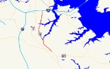
Maryland Route 10, also known as the Arundel Expressway, is a state highway
and freeway in Anne Arundel County, Maryland
, United States
.
(Ritchie Highway) in Pasadena
and serves mostly to bypass Ritchie Highway through Glen Burnie
. MD 10 helped to relieve traffic congestion
in that area prior to the construction of Interstate 97
, despite it going no further south than MD 100 and MD 2.
Despite its short length and lack of interchanges, the highway is six lanes wide between MD 177
and MD 710
, a reminder of the route's planned importance.
The highway interchanges with Maryland Route 100
via a flat crossover junction, where each route switches to the other route's through carriageway, forcing traffic from each route to weave across itself to continue on the same route.
, to relieve the congestion of Ritchie Highway between Baltimore and Annapolis. However, the continuation of the highway was canceled after major protests from the owners of properties within the highway's path. The desire to relieve MD 2, often described as a 25-mile "shopping strip", led to the upgrade of the MD 3
-MD 178
corridor into Interstate 97
.
.
State highway
State highway, state road or state route can refer to one of three related concepts, two of them related to a state or provincial government in a country that is divided into states or provinces :#A...
and freeway in Anne Arundel County, Maryland
Anne Arundel County, Maryland
Anne Arundel County is a county located in the U.S. state of Maryland. It is named for Anne Arundell , a member of the ancient family of Arundells in Cornwall, England and the wife of Cæcilius Calvert, 2nd Baron Baltimore. Its county seat is Annapolis, which is also the capital of the state...
, United States
United States
The United States of America is a federal constitutional republic comprising fifty states and a federal district...
.
Route description
The highway runs from the Baltimore Beltway south to an intersection with Maryland Route 2Maryland Route 2
Maryland Route 2 is the longest state highway in the U.S. state of Maryland. The route runs from Solomons Island in Calvert County north to an intersection with U.S. Route 1 and U.S. Route 40 Truck in Baltimore...
(Ritchie Highway) in Pasadena
Pasadena, Maryland
Pasadena is a census-designated place in Anne Arundel County, Maryland, United States. The population was 12,093 at the 2000 census.-Geography:Pasadena is located at ....
and serves mostly to bypass Ritchie Highway through Glen Burnie
Glen Burnie, Maryland
Glen Burnie is a census-designated place in Anne Arundel County, Maryland, United States, and is a suburb of Baltimore. The population was 67,639 at the 2010 census...
. MD 10 helped to relieve traffic congestion
Traffic congestion
Traffic congestion is a condition on road networks that occurs as use increases, and is characterized by slower speeds, longer trip times, and increased vehicular queueing. The most common example is the physical use of roads by vehicles. When traffic demand is great enough that the interaction...
in that area prior to the construction of Interstate 97
Interstate 97
Interstate 97 is an intrastate Interstate Highway located entirely within Anne Arundel County, Maryland, United States. It runs from Annapolis at the overlapped section of US 50, US 301, and the unsigned I-595 to Baltimore at the city's beltway...
, despite it going no further south than MD 100 and MD 2.
Despite its short length and lack of interchanges, the highway is six lanes wide between MD 177
Maryland Route 177
Maryland Route 177 is a state route in Anne Arundel County, beginning at MD 2 in Pasadena and ending at Gibson Island. It is named 'Mountain Road' for its entire length.-Route description:...
and MD 710
Maryland Route 710
Maryland Route 710 is a state highway in the U.S. state of Maryland. Known as East Ordnance Road, the state highway runs from MD 2 in Glen Burnie east to MD 173 in Brooklyn Park at the city limits of Baltimore. MD 710 provides access to the Defense Logistics Agency Curtis Bay Depot, a unit of...
, a reminder of the route's planned importance.
The highway interchanges with Maryland Route 100
Maryland Route 100
Maryland Route 100 is a major east–west highway connecting U.S. Route 29 in Ellicott City and MD 177 in Pasadena. MD 100 also connects to Interstate 95 , US 1, the Baltimore-Washington Parkway , and I-97...
via a flat crossover junction, where each route switches to the other route's through carriageway, forcing traffic from each route to weave across itself to continue on the same route.
History
MD 10 was to have continued south of MD 2 to AnnapolisAnnapolis, Maryland
Annapolis is the capital of the U.S. state of Maryland, as well as the county seat of Anne Arundel County. It had a population of 38,394 at the 2010 census and is situated on the Chesapeake Bay at the mouth of the Severn River, south of Baltimore and about east of Washington, D.C. Annapolis is...
, to relieve the congestion of Ritchie Highway between Baltimore and Annapolis. However, the continuation of the highway was canceled after major protests from the owners of properties within the highway's path. The desire to relieve MD 2, often described as a 25-mile "shopping strip", led to the upgrade of the MD 3
Maryland Route 3
Maryland Route 3, also part of Robert Crain Highway, is the designation given to the former alignment of U.S. Route 301 from Bowie, Maryland, USA, to Baltimore. It is named for Robert Crain of Baltimore.-Route description:...
-MD 178
Maryland Route 178
Maryland Route 178, known locally as Generals Highway, is a north–south highway in Anne Arundel County, Maryland. It parallels Interstate 97 and once was the main eastbound route to Annapolis, Maryland. It begins at its intersection with Maryland Route 450 in Parole, near the Westfield...
corridor into Interstate 97
Interstate 97
Interstate 97 is an intrastate Interstate Highway located entirely within Anne Arundel County, Maryland, United States. It runs from Annapolis at the overlapped section of US 50, US 301, and the unsigned I-595 to Baltimore at the city's beltway...
.
Exit list
Exit numbers are not marked on MD 10. The entire route is in Anne Arundel CountyAnne Arundel County, Maryland
Anne Arundel County is a county located in the U.S. state of Maryland. It is named for Anne Arundell , a member of the ancient family of Arundells in Cornwall, England and the wife of Cæcilius Calvert, 2nd Baron Baltimore. Its county seat is Annapolis, which is also the capital of the state...
.
| Location | Mile | Destinations | Notes |
|---|---|---|---|
| Pasadena Pasadena, Maryland Pasadena is a census-designated place in Anne Arundel County, Maryland, United States. The population was 12,093 at the 2000 census.-Geography:Pasadena is located at .... |
0.0 | southbound exit and northbound entrance; at-grade intersection At-grade intersection An at-grade intersection is a junction at which two or more transport axes cross at the same level .-Traffic management:With areas of high or fast traffic, an at-grade intersection normally requires a traffic control device such as a stop sign, traffic light or railway signal to manage conflicting... |
|
| 0.8 | southbound exit and northbound entrance; MD 100 joins northbound and leaves southbound | ||
| 1.3 | northbound exit and southbound entrance; MD 100 joins southbound and leaves northbound | ||
| 1.7 | southbound exit and northbound entrance | ||
| Harundale Harundale, Maryland Harundale is an unincorporated community in Anne Arundel County, Maryland, United States.... |
3.6 | ||
| Glen Burnie Glen Burnie, Maryland Glen Burnie is a census-designated place in Anne Arundel County, Maryland, United States, and is a suburb of Baltimore. The population was 67,639 at the 2010 census... |
5.0 | ||
| 6.2 | |||
| 7.2 | , Key Bridge | northbound exit and southbound entrance | |
| northbound exit and southbound entrance |