
Maryland Route 173
Encyclopedia
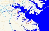
Maryland Route 173 is a state highway
in the U.S. state
of Maryland
. Known for most of its length as Fort Smallwood Road, the state highway runs 13.78 mi (22.2 km) from Fort Smallwood Park
near Fairview
north to MD 2
in the Brooklyn
neighborhood of Baltimore. MD 173 connects the beach communities of Riviera Beach
and Orchard Beach
in northeastern Anne Arundel County
with industrial areas in the Baltimore neighborhoods of Hawkins Point and Curtis Bay
, including the United States Coast Guard Yard
. As the primary connection between Interstate 695
(I-695) and industrial facilities in Curtis Bay, the state highway is part of the National Highway System
as an intermodal
connector between Quarantine Road in Hawkins Point and Patapsco Avenue in Curtis Bay. MD 173 was originally constructed in the 1920s and 1930s. The state highway was put in its modern form with the completion of the bridge over Stony Creek in the late 1940s and expansion to a divided highway along part of its length in the 1970s.
, where the speed limit drops to 40 mph (64.4 km/h) and the state highway meets the northern end of MD 607
(Hog Neck Road). The state highway crosses Rock Creek and passes a section of old alignment designated MD 173A before the intersection with Edwin Raynor Boulevard, where the state highway turns north onto a four-lane divided highway. MD 173 passes Northeast Senior High School
before the highway reduces to a three-lane road with center turn lane at the intersection with Duvall Highway.
MD 173 continues north into Riviera Beach
. At the intersection with Riviera Drive and Bar Harbor Road, the state highway turns west. The speed limit decreases to 35 mph (56.3 km/h) and the highway crosses Stony Creek on a drawbridge
. In Orchard Beach
, MD 173 passes MD 642 (Greenland Beach Road), then expands to a five-lane road with center turn lane. At Cox Creek, the state highway becomes a four-lane divided highway with a speed limit of 50 mph (80.5 km/h) and passes the Herbert A. Wagner Generating Station
. MD 173 turns north at Solley Road and passes Marley Neck Boulevard before entering the city of Baltimore. Upon entering Hawkins Point, the state highway meets Fort Armistead Road, which leads to Fort Armistead Park and an entrance ramp to eastbound I-695 (Baltimore Beltway). MD 173 turns west and its name changes to Hawkins Point Road before the highway intersects Quarantine Road, which leads to Interchange 1 of I-695.
MD 173 continues west as a four-lane undivided highway through the industrial area of Hawkins Point. The state highway passes MD 172 (Arundel Cove Road) and then the access road to the U.S. Coast Guard Yard. MD 173 crosses a CSX
railroad line and expands to a divided highway. The state highway, now named Pennington Avenue, crosses under I-695 and then over Curtis Creek
on a drawbridge. The state highway meets MD 710
(Ordnance Road) before reducing to an undivided highway and crossing Cabin Branch. MD 173 continues north across a CSX rail line at-grade and enters the neighborhood of Curtis Bay. At Birch Street, the northbound direction of MD 173 turns east and then north onto Curtis Avenue, while the southbound direction uses Pennington Avenue through the neighborhood. Curtis Avenue divides the residential and industrial portions of the neighborhood. MD 173 meets MD 171
(Church Street) within Curtis Bay. At the northern end of the neighborhood, the one-way pair
ends and MD 173 turns west onto Patapsco Avenue toward Brooklyn. The state highway crosses MD 686 (2nd Street) before the westbound direction has an entrance ramp to I-895
(Harbor Tunnel Thruway). MD 173 then meets its western terminus at MD 2 (Potee Street). Patapsco Avenue continues as a municipal highway across the Patapsco River
toward Southwest Baltimore.
for a bypassed section of MD 173 near the intersection of that highway and Edwin Raynor Boulevard. MD 173A runs 0.14 mi (0.2253076 km) from MD 173 north to Rock Hill Road near Jacobsville. The state highway was assigned in 2001 when the intersection of MD 173 and Edwin Raynor Boulevard was rebuilt so the roads meet at a right angle.
State highway
State highway, state road or state route can refer to one of three related concepts, two of them related to a state or provincial government in a country that is divided into states or provinces :#A...
in the U.S. state
U.S. state
A U.S. state is any one of the 50 federated states of the United States of America that share sovereignty with the federal government. Because of this shared sovereignty, an American is a citizen both of the federal entity and of his or her state of domicile. Four states use the official title of...
of Maryland
Maryland
Maryland is a U.S. state located in the Mid Atlantic region of the United States, bordering Virginia, West Virginia, and the District of Columbia to its south and west; Pennsylvania to its north; and Delaware to its east...
. Known for most of its length as Fort Smallwood Road, the state highway runs 13.78 mi (22.2 km) from Fort Smallwood Park
Fort Smallwood Park
Fort Smallwood Park is a county park in northeastern Anne Arundel County near Pasadena, Maryland. It is located on the Patapsco River and on April 1, 2006 became a regional park in the Anne Arundel County Park System. On September 19, 2009 County Executive John R. Leopold officially dedicated the ...
near Fairview
Fairview, Anne Arundel County, Maryland
Fairview is an unincorporated community in Anne Arundel County, Maryland, United States....
north to MD 2
Maryland Route 2
Maryland Route 2 is the longest state highway in the U.S. state of Maryland. The route runs from Solomons Island in Calvert County north to an intersection with U.S. Route 1 and U.S. Route 40 Truck in Baltimore...
in the Brooklyn
Brooklyn, Baltimore
Brooklyn is one of the southernmost neighborhoods in Baltimore, Maryland. It is located near Anne Arundel County along Maryland Route 2. Its main roads are Potee Street, Hanover Street, and Patapsco Avenue. Often mistaken as Brooklyn Park, Brooklyn shares the 21225 ZIP Code with Brooklyn Park and...
neighborhood of Baltimore. MD 173 connects the beach communities of Riviera Beach
Riviera Beach, Maryland
Riviera Beach is a census-designated place and a neighborhood within Pasadena, Maryland in Anne Arundel County, Maryland, United States. The population was 12,695 at the 2000 census.Locals to the area do not pronounce the name as it is spelled...
and Orchard Beach
Orchard Beach, Maryland
Orchard Beach is an unincorporated community in Anne Arundel County, Maryland, United States....
in northeastern Anne Arundel County
Anne Arundel County, Maryland
Anne Arundel County is a county located in the U.S. state of Maryland. It is named for Anne Arundell , a member of the ancient family of Arundells in Cornwall, England and the wife of Cæcilius Calvert, 2nd Baron Baltimore. Its county seat is Annapolis, which is also the capital of the state...
with industrial areas in the Baltimore neighborhoods of Hawkins Point and Curtis Bay
Curtis Bay, Baltimore
Curtis Bay is a neighborhood in Baltimore, Maryland, United States. The neighborhood is located in a highly industrialized waterfornt area in the southern part of the city, and receives its name from the body of water in which it sits...
, including the United States Coast Guard Yard
United States Coast Guard Yard
The United States Coast Guard Yard or just Coast Guard Yard is a United States Coast Guard operated shipyard located on Curtis Bay in northern Anne Arundel County, Maryland, just south of the Baltimore city limits. It is the coast guard's sole shipbuilding and major repair facility, and part of the...
. As the primary connection between Interstate 695
Interstate 695 (Maryland)
Interstate 695 is a -long full beltway Interstate Highway extending around Baltimore, Maryland, USA. I-695 is officially designated the McKeldin Beltway, but is colloquially referred to as either the Baltimore Beltway or 695...
(I-695) and industrial facilities in Curtis Bay, the state highway is part of the National Highway System
National Highway System (United States)
The National Highway System is a network of strategic highways within the United States, including the Interstate Highway System and other roads serving major airports, ports, rail or truck terminals, railway stations, pipeline terminals and other strategic transport facilities.Individual states...
as an intermodal
Intermodal passenger transport
Intermodal passenger transport involves more than one mode of transport of passengers. Some modes of transportation have always been intermodal; for example, most major airports have extensive facilities for automobile parking and have good rail or bus connections to the cities nearby. Urban bus...
connector between Quarantine Road in Hawkins Point and Patapsco Avenue in Curtis Bay. MD 173 was originally constructed in the 1920s and 1930s. The state highway was put in its modern form with the completion of the bridge over Stony Creek in the late 1940s and expansion to a divided highway along part of its length in the 1970s.
Route description
MD 173 begins at the entrance to Fort Smallwood Park near the unincorporated community of Fairview. The state highway heads south as Fort Smallwood Road, a two-lane road with a speed limit of 45 mph (72.4 km/h) that passes by several small beach communities on the Hog Neck peninsula. After intersecting Bayside Beach Road, MD 173 turns southwest and passes along the northern edge of JacobsvilleJacobsville, Maryland
Jacobsville is an unincorporated community in Anne Arundel County, Maryland, United States....
, where the speed limit drops to 40 mph (64.4 km/h) and the state highway meets the northern end of MD 607
Maryland Route 607
Maryland Route 607 is a state highway in the U.S. state of Maryland. The state highway runs from the beginning of state maintenance south of MD 100 north to MD 173 in Jacobsville.-Route description:...
(Hog Neck Road). The state highway crosses Rock Creek and passes a section of old alignment designated MD 173A before the intersection with Edwin Raynor Boulevard, where the state highway turns north onto a four-lane divided highway. MD 173 passes Northeast Senior High School
Northeast Senior High School (Pasadena, Maryland)
Northeast Senior High School is located at 1121 Duvall Hwy. in Pasadena, Maryland, United States. The school opened in 1964 and serves as one of two high schools, the other being Chesapeake High School, for the CDP of Pasadena...
before the highway reduces to a three-lane road with center turn lane at the intersection with Duvall Highway.
MD 173 continues north into Riviera Beach
Riviera Beach, Maryland
Riviera Beach is a census-designated place and a neighborhood within Pasadena, Maryland in Anne Arundel County, Maryland, United States. The population was 12,695 at the 2000 census.Locals to the area do not pronounce the name as it is spelled...
. At the intersection with Riviera Drive and Bar Harbor Road, the state highway turns west. The speed limit decreases to 35 mph (56.3 km/h) and the highway crosses Stony Creek on a drawbridge
Drawbridge
A drawbridge is a type of movable bridge typically associated with the entrance of a castle surrounded by a moat. The term is often used to describe all different types of movable bridges, like bascule bridges and lift bridges.-Castle drawbridges:...
. In Orchard Beach
Orchard Beach, Maryland
Orchard Beach is an unincorporated community in Anne Arundel County, Maryland, United States....
, MD 173 passes MD 642 (Greenland Beach Road), then expands to a five-lane road with center turn lane. At Cox Creek, the state highway becomes a four-lane divided highway with a speed limit of 50 mph (80.5 km/h) and passes the Herbert A. Wagner Generating Station
Herbert A. Wagner Generating Station
The Herbert A. Wagner Generating Station is an electric generating station, located on Fort Smallwood Road north of Orchard Beach in Anne Arundel County, Maryland, just east of Glen Burnie, and is operated by the Constellation Power Source Generation subsidiary of Constellation Energy Group. The H. A...
. MD 173 turns north at Solley Road and passes Marley Neck Boulevard before entering the city of Baltimore. Upon entering Hawkins Point, the state highway meets Fort Armistead Road, which leads to Fort Armistead Park and an entrance ramp to eastbound I-695 (Baltimore Beltway). MD 173 turns west and its name changes to Hawkins Point Road before the highway intersects Quarantine Road, which leads to Interchange 1 of I-695.
MD 173 continues west as a four-lane undivided highway through the industrial area of Hawkins Point. The state highway passes MD 172 (Arundel Cove Road) and then the access road to the U.S. Coast Guard Yard. MD 173 crosses a CSX
CSX Transportation
CSX Transportation operates a Class I railroad in the United States known as the CSX Railroad. It is the main subsidiary of the CSX Corporation. The company is headquartered in Jacksonville, Florida, and owns approximately 21,000 route miles...
railroad line and expands to a divided highway. The state highway, now named Pennington Avenue, crosses under I-695 and then over Curtis Creek
Curtis Creek
Curtis Creek is a tidal creek located in Baltimore City and Anne Arundel County, Maryland. It is a tributary of Curtis Bay. The creek begins at the confluence of Furnace Creek and Marley Creek and flows north about to Curtis Bay.-External links:**...
on a drawbridge. The state highway meets MD 710
Maryland Route 710
Maryland Route 710 is a state highway in the U.S. state of Maryland. Known as East Ordnance Road, the state highway runs from MD 2 in Glen Burnie east to MD 173 in Brooklyn Park at the city limits of Baltimore. MD 710 provides access to the Defense Logistics Agency Curtis Bay Depot, a unit of...
(Ordnance Road) before reducing to an undivided highway and crossing Cabin Branch. MD 173 continues north across a CSX rail line at-grade and enters the neighborhood of Curtis Bay. At Birch Street, the northbound direction of MD 173 turns east and then north onto Curtis Avenue, while the southbound direction uses Pennington Avenue through the neighborhood. Curtis Avenue divides the residential and industrial portions of the neighborhood. MD 173 meets MD 171
Maryland Route 171
Maryland Route 171 is a state highway in the U.S. state of Maryland. Known as Church Street, the state highway runs from MD 2 in Brooklyn Park east to MD 173 in the Curtis Bay neighborhood of Baltimore...
(Church Street) within Curtis Bay. At the northern end of the neighborhood, the one-way pair
One-way pair
A one-way pair, one-way couple, or just couplet is a pair of parallel, usually one-way streets that carry opposite directions of a signed route or major traffic flow, or sometimes opposite directions of a bus or streetcar route....
ends and MD 173 turns west onto Patapsco Avenue toward Brooklyn. The state highway crosses MD 686 (2nd Street) before the westbound direction has an entrance ramp to I-895
Interstate 895 (Maryland)
Interstate 895 is an Interstate Highway in the U.S. state of Maryland. Known as the Harbor Tunnel Thruway, the highway runs between one junction with I-95 in Elkridge and another interchange with I-95 on the east side of Baltimore. I-895 is a toll road that crosses the Patapsco River estuary...
(Harbor Tunnel Thruway). MD 173 then meets its western terminus at MD 2 (Potee Street). Patapsco Avenue continues as a municipal highway across the Patapsco River
Patapsco River
The Patapsco River is a river in central Maryland which flows into Chesapeake Bay. The river's tidal portion forms the harbor for the city of Baltimore...
toward Southwest Baltimore.
History
MD 173 was paved from MD 2 to the southern end of the Curtis Bay neighborhood, as well as from MD 172 to Marley Neck Road in Orchard Beach, in 1927. By 1930, pavement was extended east to Stony Creek. The highway was completed in Anne Arundel County in 1933 and within Baltimore by 1935. The present bridge over Stony Creek was constructed in 1947, replacing a one-lane bridge. MD 173 was widened from Orchard Beach to MD 710 in the late 1970s and north to the Curtis Bay neighborhood in the mid 1980s.Junction list
| County | Location | Mile |
Destinations | Notes |
|---|---|---|---|---|
| Anne Arundel Anne Arundel County, Maryland Anne Arundel County is a county located in the U.S. state of Maryland. It is named for Anne Arundell , a member of the ancient family of Arundells in Cornwall, England and the wife of Cæcilius Calvert, 2nd Baron Baltimore. Its county seat is Annapolis, which is also the capital of the state... 8.92 miles (14.4 km) |
Fairview Fairview, Anne Arundel County, Maryland Fairview is an unincorporated community in Anne Arundel County, Maryland, United States.... |
0.00 | Entrance to Fort Smallwood Park Fort Smallwood Park Fort Smallwood Park is a county park in northeastern Anne Arundel County near Pasadena, Maryland. It is located on the Patapsco River and on April 1, 2006 became a regional park in the Anne Arundel County Park System. On September 19, 2009 County Executive John R. Leopold officially dedicated the ... |
Southern terminus |
| Jacobsville Jacobsville, Maryland Jacobsville is an unincorporated community in Anne Arundel County, Maryland, United States.... |
3.00 | |||
| 3.91 | Edwin Raynor Boulevard south – Pasadena Pasadena, Maryland Pasadena is a census-designated place in Anne Arundel County, Maryland, United States. The population was 12,093 at the 2000 census.-Geography:Pasadena is located at .... |
MD 173 turns north at this intersection | ||
| Riviera Beach Riviera Beach, Maryland Riviera Beach is a census-designated place and a neighborhood within Pasadena, Maryland in Anne Arundel County, Maryland, United States. The population was 12,695 at the 2000 census.Locals to the area do not pronounce the name as it is spelled... |
5.18 | Bar Harbor Road east / Riviera Drive north | MD 173 turns west at this intersection | |
| Baltimore City 4.86 miles (7.8 km) |
Fort Armistead Road east to | |||
| Quarantine Road north to | ||||
| Patapsco Avenue east – Port of Baltimore Helen Delich Bentley Port of Baltimore Helen Delich Bentley Port of Baltimore, Baltimore, Maryland, consists of seaport facilities for cargo, especially roll-on/roll-off ships, and passengers operated by the Maryland Port Administration , a unit of the Maryland Department of Transportation.... |
MD 173 turns west onto Patapsco Avenue | |||
| – New York New York City New York is the most populous city in the United States and the center of the New York Metropolitan Area, one of the most populous metropolitan areas in the world. New York exerts a significant impact upon global commerce, finance, media, art, fashion, research, technology, education, and... |
Exit from westbound MD 173 | |||
| Northern terminus | ||||
| Patapsco Avenue west | ||||
Auxiliary route
MD 173A is the unsigned designationUnsigned highway
An unsigned highway is a highway that has been assigned a route number, but does not bear conventional road markings that would normally be used to identify the route with that number...
for a bypassed section of MD 173 near the intersection of that highway and Edwin Raynor Boulevard. MD 173A runs 0.14 mi (0.2253076 km) from MD 173 north to Rock Hill Road near Jacobsville. The state highway was assigned in 2001 when the intersection of MD 173 and Edwin Raynor Boulevard was rebuilt so the roads meet at a right angle.