
Maryland Route 108
Encyclopedia
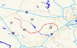
Maryland Route 108 is a suburban state highway
in the central part of the U.S. state
of Maryland
, starting in Damascus and ending near Columbia.
and Baltimore
. It begins at Maryland Route 27
in Damascus
, located in northern Montgomery County
. It then proceeds to sweep south through farmland towards Olney
where it intersects with MD 97
, also known as Georgia Avenue
.
 It then travels east towards the Patuxent River
, passing the historic communities of Sandy Spring
and Ashton
, where it crosses MD 650
New Hampshire Avenue
.
After crossing the Patuxent into Howard County
, MD 108 trends back north to Clarksville
, where it crosses MD 32
.
It then trends east again, forming the northern border of the planned community of Columbia
and intersecting with US 29
, a major north–south thoroughfare. The road then takes its final curve south, ending at Maryland Route 175
just west of Interstate 95
in the vicinity of Guilford
.
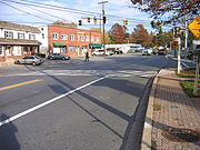
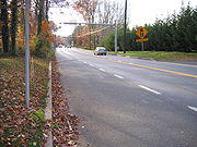
The road generally follows a two-lane format. At major intersections, such as those at MD 32 and MD 29, it expands to four lanes. The stretch of the road around Olney is the only exception to this rule, forming four lanes for several miles due to the commercial nature of the area.
in Columbia and its intersection with Maryland Route 650
(New Hampshire Avenue
) in Ashton
is the former route of US 29 prior to the start of construction of the planned community
of Columbia
, which began in the late 1960s; the route forms the northern boundary of the town. Before the diversion of US 29, MD 108 ended in Ashton at an intersection with the U.S. route.
The section of MD 108 between MD 104
(in Ellicott City
) and the route's eastern terminus at MD 175
was a former alignment of MD 175 before the construction of 175's current route through the heart of Columbia.
The segment of MD 108 between US 29 and MD 104
was once designated Maryland Route 539.
Before the construction of the Patuxent Freeway between MD 108 and US 29, MD 32
once overlapped MD 108 through Clarksville
for a short distance before turning onto a new alignment. The western end of the concurrency was at Guilford Rd., while the eastern end is now Exit 20 from MD 32.
State highway
State highway, state road or state route can refer to one of three related concepts, two of them related to a state or provincial government in a country that is divided into states or provinces :#A...
in the central part of the U.S. state
U.S. state
A U.S. state is any one of the 50 federated states of the United States of America that share sovereignty with the federal government. Because of this shared sovereignty, an American is a citizen both of the federal entity and of his or her state of domicile. Four states use the official title of...
of Maryland
Maryland
Maryland is a U.S. state located in the Mid Atlantic region of the United States, bordering Virginia, West Virginia, and the District of Columbia to its south and west; Pennsylvania to its north; and Delaware to its east...
, starting in Damascus and ending near Columbia.
Route description
Maryland Route 108 takes a very sinuous route through the Maryland exurbs located in between Washington, D.C.Washington, D.C.
Washington, D.C., formally the District of Columbia and commonly referred to as Washington, "the District", or simply D.C., is the capital of the United States. On July 16, 1790, the United States Congress approved the creation of a permanent national capital as permitted by the U.S. Constitution....
and Baltimore
Baltimore
Baltimore is the largest independent city in the United States and the largest city and cultural center of the US state of Maryland. The city is located in central Maryland along the tidal portion of the Patapsco River, an arm of the Chesapeake Bay. Baltimore is sometimes referred to as Baltimore...
. It begins at Maryland Route 27
Maryland Route 27
Maryland Route 27 is a state highway in the central part of the U.S. state of Maryland.-Route description:MD 27, also known as Ridge Road and Manchester Road , begins in Germantown at MD 355...
in Damascus
Damascus, Maryland
Damascus is a census-designated place and an unincorporated area in Montgomery County, Maryland, United States.In the early part of the 20th century, there was an incorporated municipality there for about a quarter century, but it no longer exists...
, located in northern Montgomery County
Montgomery County, Maryland
Montgomery County is a county in the U.S. state of Maryland, situated just to the north of Washington, D.C., and southwest of the city of Baltimore. It is one of the most affluent counties in the United States, and has the highest percentage of residents over 25 years of age who hold post-graduate...
. It then proceeds to sweep south through farmland towards Olney
Olney, Maryland
Olney, a census-designated place and an unincorporated area of Montgomery County, Maryland, USA, is located in the north central part of the county, twenty miles north of Washington, D.C. It was largely agricultural until the 1960s, when growth of the Washington suburbs led to its conversion into...
where it intersects with MD 97
Maryland Route 97
Maryland Route 97 is a state highway in the U.S. state of Maryland. The route runs from U.S. Route 29 in Silver Spring, Montgomery County north to the Pennsylvania border in Carroll County, where the road continues into that state as Pennsylvania Route 97...
, also known as Georgia Avenue
Georgia Avenue
Georgia Avenue is a major north-south artery in Northwest Washington, D.C. and Montgomery County, Maryland. Within the District of Columbia and a short distance in Silver Spring, Maryland, Georgia Avenue is also U.S. Route 29...
.
Patuxent River
The Patuxent River is a tributary of the Chesapeake Bay in the state of Maryland. There are three main river drainages for central Maryland: the Potomac River to the west passing through Washington D.C., the Patapsco River to the northeast passing through Baltimore, and the Patuxent River between...
, passing the historic communities of Sandy Spring
Sandy Spring, Maryland
Sandy Spring, Maryland is an unincorporated community in Montgomery County, Maryland.The community was founded by Quakers who arrived in the early 18th century searching for land where they could grow tobacco and corn. One of the very early land owners in the Sandy Spring area was Richard Snowden,...
and Ashton
Ashton, Maryland
Ashton is an unincorporated area in Montgomery County, Maryland. The commercial center of Ashton lies at the junction of Route 108 and New Hampshire Avenue ....
, where it crosses MD 650
Maryland Route 650
Maryland Route 650 is a state highway in the U.S. state of Maryland. Known as New Hampshire Avenue for most of its length, the state highway runs from Eastern Avenue at the Washington, D.C. border north to MD 108 in Etchison...
New Hampshire Avenue
New Hampshire Avenue
New Hampshire Avenue is a diagonal street in Washington, D.C., beginning at the Kennedy Center and extending northeast for about 5 miles and then continuing into Maryland where it is designated Maryland Route 650. New Hampshire Avenue, however, is not contiguous...
.
After crossing the Patuxent into Howard County
Howard County, Maryland
-2010:Whereas according to the 2010 U.S. Census Bureau:*62.2% White*17.5% Black*0.3% Native American*14.4% Asian*0.0% Native Hawaiian or Pacific Islander*3.6% Two or more races*2.0% Other races*5.8% Hispanic or Latino -2000:...
, MD 108 trends back north to Clarksville
Clarksville, Maryland
Clarksville is both the name of an unincorporated community and the name associated with Districts 4 & 5 in Howard County, the third wealthiest county in the United States according to the U.S. Census Bureau. The community is named for William Clark, a farmer who owned much of the land on which the...
, where it crosses MD 32
Maryland Route 32
Maryland Route 32 is a state highway in the U.S. state of Maryland. The state highway runs from Interstate 97 and MD 3 in Millersville west and north to Washington Road in Westminster. The east–west portion of MD 32 is the Patuxent Freeway, a four- to six-lane...
.
It then trends east again, forming the northern border of the planned community of Columbia
Columbia, Maryland
Columbia is a planned community that consists of ten self-contained villages, located in Howard County, Maryland, United States. It began with the idea that a city could enhance its residents' quality of life. Creator and developer James W. Rouse saw the new community in terms of human values, not...
and intersecting with US 29
U.S. Route 29 in Maryland
U.S. Route 29 is a north–south United States highway that runs for from the western suburbs of Baltimore, Maryland, to Pensacola, Florida. In the U.S. state of Maryland, US 29 is a major highway that emerges from Washington D.C. and runs north into eastern Montgomery County, stretching...
, a major north–south thoroughfare. The road then takes its final curve south, ending at Maryland Route 175
Maryland Route 175
-Annapolis Road:MD 175 begins at MD 3, just south of the latter's northern terminus at Interstate 97, known as Annapolis Road. It runs west as a two-lane suburban highway, passing through local neighborhoods and south of Arundel High School before widening into a four-lane suburban arterial south...
just west of Interstate 95
Interstate 95 in Maryland
Interstate 95 in Maryland is a major highway that runs diagonally from northeast to southwest, from Maryland's border with Delaware, to the Woodrow Wilson Bridge, briefly entering the District of Columbia before reaching Virginia...
in the vicinity of Guilford
Guilford, Maryland
Guilford is a community located in Howard County in the state of Maryland in the United States of America. Formerly a small railroad stop, it now lies within the boundaries of Columbia....
.
The road generally follows a two-lane format. At major intersections, such as those at MD 32 and MD 29, it expands to four lanes. The stretch of the road around Olney is the only exception to this rule, forming four lanes for several miles due to the commercial nature of the area.
History
The section between the route's current interchange with US 29U.S. Route 29 in Maryland
U.S. Route 29 is a north–south United States highway that runs for from the western suburbs of Baltimore, Maryland, to Pensacola, Florida. In the U.S. state of Maryland, US 29 is a major highway that emerges from Washington D.C. and runs north into eastern Montgomery County, stretching...
in Columbia and its intersection with Maryland Route 650
Maryland Route 650
Maryland Route 650 is a state highway in the U.S. state of Maryland. Known as New Hampshire Avenue for most of its length, the state highway runs from Eastern Avenue at the Washington, D.C. border north to MD 108 in Etchison...
(New Hampshire Avenue
New Hampshire Avenue
New Hampshire Avenue is a diagonal street in Washington, D.C., beginning at the Kennedy Center and extending northeast for about 5 miles and then continuing into Maryland where it is designated Maryland Route 650. New Hampshire Avenue, however, is not contiguous...
) in Ashton
Ashton, Maryland
Ashton is an unincorporated area in Montgomery County, Maryland. The commercial center of Ashton lies at the junction of Route 108 and New Hampshire Avenue ....
is the former route of US 29 prior to the start of construction of the planned community
Planned community
A planned community, or planned city, is any community that was carefully planned from its inception and is typically constructed in a previously undeveloped area. This contrasts with settlements that evolve in a more ad hoc fashion. Land use conflicts are less frequent in planned communities since...
of Columbia
Columbia, Maryland
Columbia is a planned community that consists of ten self-contained villages, located in Howard County, Maryland, United States. It began with the idea that a city could enhance its residents' quality of life. Creator and developer James W. Rouse saw the new community in terms of human values, not...
, which began in the late 1960s; the route forms the northern boundary of the town. Before the diversion of US 29, MD 108 ended in Ashton at an intersection with the U.S. route.
The section of MD 108 between MD 104
Maryland Route 104
Maryland Route 104 is a state highway in the U.S. state of Maryland. Known as Waterloo Road, the state highway runs from MD 108 in Columbia north to MD 103 in Ellicott City. MD 104 connects MD 108, MD 103, and MD 100 in northeastern Howard County. The state highway was originally constructed...
(in Ellicott City
Ellicott City, Maryland
Ellicott City is an unincorporated community and census-designated place in Howard County, Maryland, United States. It is part of the Baltimore-Washington Metropolitan Area. The population was 65,834 at the 2010 census. It is the county seat of Howard County...
) and the route's eastern terminus at MD 175
Maryland Route 175
-Annapolis Road:MD 175 begins at MD 3, just south of the latter's northern terminus at Interstate 97, known as Annapolis Road. It runs west as a two-lane suburban highway, passing through local neighborhoods and south of Arundel High School before widening into a four-lane suburban arterial south...
was a former alignment of MD 175 before the construction of 175's current route through the heart of Columbia.
The segment of MD 108 between US 29 and MD 104
Maryland Route 104
Maryland Route 104 is a state highway in the U.S. state of Maryland. Known as Waterloo Road, the state highway runs from MD 108 in Columbia north to MD 103 in Ellicott City. MD 104 connects MD 108, MD 103, and MD 100 in northeastern Howard County. The state highway was originally constructed...
was once designated Maryland Route 539.
Before the construction of the Patuxent Freeway between MD 108 and US 29, MD 32
Maryland Route 32
Maryland Route 32 is a state highway in the U.S. state of Maryland. The state highway runs from Interstate 97 and MD 3 in Millersville west and north to Washington Road in Westminster. The east–west portion of MD 32 is the Patuxent Freeway, a four- to six-lane...
once overlapped MD 108 through Clarksville
Clarksville, Maryland
Clarksville is both the name of an unincorporated community and the name associated with Districts 4 & 5 in Howard County, the third wealthiest county in the United States according to the U.S. Census Bureau. The community is named for William Clark, a farmer who owned much of the land on which the...
for a short distance before turning onto a new alignment. The western end of the concurrency was at Guilford Rd., while the eastern end is now Exit 20 from MD 32.
Junction list
| County | Location | Mile | Destinations | Notes |
|---|---|---|---|---|
| Montgomery Montgomery County, Maryland Montgomery County is a county in the U.S. state of Maryland, situated just to the north of Washington, D.C., and southwest of the city of Baltimore. It is one of the most affluent counties in the United States, and has the highest percentage of residents over 25 years of age who hold post-graduate... |
Damascus Damascus, Maryland Damascus is a census-designated place and an unincorporated area in Montgomery County, Maryland, United States.In the early part of the 20th century, there was an incorporated municipality there for about a quarter century, but it no longer exists... |
0.00 | Western terminus | |
| 0.15 | ||||
| Bootjack | 2.95 | Long Corner Road – Long Corner | ||
| 3.32 | Annapolis Rock Road – Patuxent River State Park Patuxent River State Park Patuxent River State Park is a state park in the state of Maryland. The park is located along the upper reaches of the Patuxent River in Howard and Montgomery Counties. The park features hunting, fishing, hiking and horseback riding.-External links:*... |
|||
| Etchinson | 4.44 | , Rachel Carson Conservation Park | ||
| Laytonsville Laytonsville, Maryland Laytonsville is a town in Montgomery County, Maryland, United States. The population was 277 at the 2000 census. Laytonsville was originally known as Cracklintown. This name originated from the popular cracklin bread, which was baked in the locale. This recipe, essentially a bacon corn bread, also... |
7.40 | Sundown Road / Brink Road | ||
| Claysville | 9.46 | Fieldcrest Rd. west - Laytonsville Golf Course (to  MD 124 MD 124Maryland Route 124 Maryland Route 124 is a mixed suburban and semi-rural road that runs through several suburbs and exurbs to the north of Washington, DC in Montgomery County, Maryland. It changes names several times over its length, beginning as Quince Orchard Road near Darnestown and terminating as Woodfield Road... ) |
||
| Mt Zion | 10.17 | Brookeville Rd. east - Brookeville Brookeville, Maryland Brookeville is a town located twenty miles north of Washington, D.C. and two miles north of Olney in northeastern Montgomery County, Maryland. Brookeville was settled by Quakers late in the 18th century, and was formally incorporated as a town in 1808... (to  MD 97 MD 97Maryland Route 97 Maryland Route 97 is a state highway in the U.S. state of Maryland. The route runs from U.S. Route 29 in Silver Spring, Montgomery County north to the Pennsylvania border in Carroll County, where the road continues into that state as Pennsylvania Route 97... ) |
||
| Olney Olney, Maryland Olney, a census-designated place and an unincorporated area of Montgomery County, Maryland, USA, is located in the north central part of the county, twenty miles north of Washington, D.C. It was largely agricultural until the 1960s, when growth of the Washington suburbs led to its conversion into... |
13.36 | Maryland Route 97 Maryland Route 97 Maryland Route 97 is a state highway in the U.S. state of Maryland. The route runs from U.S. Route 29 in Silver Spring, Montgomery County north to the Pennsylvania border in Carroll County, where the road continues into that state as Pennsylvania Route 97... / Georgia Ave. - Cooksville Cooksville, Maryland Cooksville is an unincorporated community in Howard County, Maryland, United States. Roberts Inn was listed on the National Register of Historic Places in 1973.-References:... , Silver Spring Silver Spring, Maryland Silver Spring is an unincorporated area and census-designated place in Montgomery County, Maryland, United States. It had a population of 71,452 at the 2010 census, making it the fourth most populous place in Maryland, after Baltimore, Columbia, and Germantown.The urbanized, oldest, and... |
||
| 14.37 | Old Baltimore Rd. south - to MD 97 Maryland Route 97 Maryland Route 97 is a state highway in the U.S. state of Maryland. The route runs from U.S. Route 29 in Silver Spring, Montgomery County north to the Pennsylvania border in Carroll County, where the road continues into that state as Pennsylvania Route 97... |
|||
| Sandy Spring Sandy Spring, Maryland Sandy Spring, Maryland is an unincorporated community in Montgomery County, Maryland.The community was founded by Quakers who arrived in the early 18th century searching for land where they could grow tobacco and corn. One of the very early land owners in the Sandy Spring area was Richard Snowden,... |
14.79 |  Maryland Route 182 Maryland Route 182Maryland Route 182 Maryland Route 182 is a road that runs between Olney and Glenmont, Maryland. The road is first known as Dr. Bird Road for a short distance before becoming Norwood Road. When the road reaches Norwood, a right turn is required to stay on the route, which for its remainder is known as Layhill Road... south / Dr Bird Rd. - Norwood, Woodmont |
||
| Ashton Ashton, Maryland Ashton is an unincorporated area in Montgomery County, Maryland. The commercial center of Ashton lies at the junction of Route 108 and New Hampshire Avenue .... |
16.57 |  Maryland Route 650 Maryland Route 650Maryland Route 650 Maryland Route 650 is a state highway in the U.S. state of Maryland. Known as New Hampshire Avenue for most of its length, the state highway runs from Eastern Avenue at the Washington, D.C. border north to MD 108 in Etchison... / New Hampshire Ave. - Brinklow Brinklow, Maryland Brinklow is an unincorporated community in Montgomery County, Maryland, United States. Brinklow is located on Maryland Route 650 northeast of Olney. Brinklow has a post office with ZIP code 20862.... , White Oak White Oak, Maryland White Oak is a census-designated place and an unincorporated area in Montgomery County, Maryland, United States.-Geography:As an unincorporated area, White Oak's boundaries are not officially defined... (to  US 29 US 29U.S. Route 29 in Maryland U.S. Route 29 is a north–south United States highway that runs for from the western suburbs of Baltimore, Maryland, to Pensacola, Florida. In the U.S. state of Maryland, US 29 is a major highway that emerges from Washington D.C. and runs north into eastern Montgomery County, stretching... ) |
south and  east are former route of ; north is former route of east are former route of ; north is former route of  |
|
| 17.40 | Mink Hollow Rd. north - to Highland Rd. | |||
| Howard Howard County, Maryland -2010:Whereas according to the 2010 U.S. Census Bureau:*62.2% White*17.5% Black*0.3% Native American*14.4% Asian*0.0% Native Hawaiian or Pacific Islander*3.6% Two or more races*2.0% Other races*5.8% Hispanic or Latino -2000:... |
Highland Highland, Maryland Highland is an unincorporated community in western Howard County, Maryland which uses the 20777 zip code. The community is located at the junction of Highland Road, Maryland Route 216 and Maryland Route 108, and is still heavily influenced by its agrarian history; farms and horse fields are common... |
20.52 |  Maryland Route 216 Maryland Route 216Maryland Route 216 Maryland Route 216 is a Maryland between Laurel and Highland, primarily within Howard County. The name for Route 216 is Scaggsville Road.-7th Street, Laurel:... south / Highland Rd. - Scaggsville Scaggsville, Maryland Scaggsville is an unincorporated community in Maryland. It is situated near the southeastern tip of Howard County, between Laurel and Fulton. The name Scaggsville appears on exits for Maryland Route 216 off Interstate 95 and U.S. Route 29. The town mainly consists of residences, with some... , Laurel Laurel, Maryland Laurel is a city in northern Prince George's County, Anne Arundel County, and Howard County, Maryland, United States, located midway between Washington, D.C. and Baltimore. Incorporated in 1870, the city maintains a historic district including its Main Street... (to  I-95 I-95Interstate 95 in Maryland Interstate 95 in Maryland is a major highway that runs diagonally from northeast to southwest, from Maryland's border with Delaware, to the Woodrow Wilson Bridge, briefly entering the District of Columbia before reaching Virginia... ) |
runs south of ; Highland Rd. continues north |
| Clarksville Clarksville, Maryland Clarksville is both the name of an unincorporated community and the name associated with Districts 4 & 5 in Howard County, the third wealthiest county in the United States according to the U.S. Census Bureau. The community is named for William Clark, a farmer who owned much of the land on which the... |
22.44 | Guilford Rd. south | former route of  |
|
| 22.64 | Ten Oaks Rd. north - to Brighton Dam Rd. | former route of |
||
| 22.73 | Maryland Route 32 Maryland Route 32 Maryland Route 32 is a state highway in the U.S. state of Maryland. The state highway runs from Interstate 97 and MD 3 in Millersville west and north to Washington Road in Westminster. The east–west portion of MD 32 is the Patuxent Freeway, a four- to six-lane... / Patuxent Freeway - Sykesville Sykesville, Maryland Sykesville is a town in Carroll County, Maryland, United States. The population was 4,197 at the 2000 census.-History:The land on which Sykesville sits started out as part of a Springfield Estate, owned by wealthy Baltimore shipbuilder William Patterson... , Columbia Columbia, Maryland Columbia is a planned community that consists of ten self-contained villages, located in Howard County, Maryland, United States. It began with the idea that a city could enhance its residents' quality of life. Creator and developer James W. Rouse saw the new community in terms of human values, not... |
grade-separated interchange between routes; freeway downgrades at interchange |
||
| 23.48 | Sheppard Ln. - to Folly Quarter Rd. | Folly Quarter Rd. formerly designated  |
||
| 25.79 | Homewood Rd.-Harpers Farm Rd. - Howard County General Hospital Howard County General Hospital Howard County General Hospital is a 227-bed, not-for-profit health care provider located in Columbia, Maryland. The hospital was opened in 1973... , Howard Community College Howard Community College Howard Community College is a community college in Columbia, Howard County, Maryland. HCC, in partnership with Prince George's Community College and 5 four year colleges, also has a campus in Laurel that is known as Laurel College Center... |
|||
| 27.45 | Centennial Ln. - Centennial Park Centennial Park Centennial Park could be:In Argentina:*Parque Centenario, a public park in Buenos AiresIn Australia:*Centennial Park Cemetery, Adelaide, South Australia, a large cemetery, approximately 40 hectares in size... , Ellicott City Ellicott City, Maryland Ellicott City is an unincorporated community and census-designated place in Howard County, Maryland, United States. It is part of the Baltimore-Washington Metropolitan Area. The population was 65,834 at the 2010 census. It is the county seat of Howard County... (to  US 40 US 40U.S. Route 40 in Maryland U.S. Route 40 in the U.S. state of Maryland runs from western Maryland to Cecil County in the state's northeastern corner. With a total length of over , it is the longest numbered highway in Maryland. Almost half of the road overlaps with Interstate 68 or Interstate 70, while the old alignment... ) |
|||
| 28.79 | Columbia Rd. - to Old Annapolis Rd. (west) | Columbia Rd. is former route of ; east of Columbia Rd. originally designated  |
||
| 29.19 | US 29 U.S. Route 29 in Maryland U.S. Route 29 is a north–south United States highway that runs for from the western suburbs of Baltimore, Maryland, to Pensacola, Florida. In the U.S. state of Maryland, US 29 is a major highway that emerges from Washington D.C. and runs north into eastern Montgomery County, stretching... / Columbia Pike - Ellicott City Ellicott City, Maryland Ellicott City is an unincorporated community and census-designated place in Howard County, Maryland, United States. It is part of the Baltimore-Washington Metropolitan Area. The population was 65,834 at the 2010 census. It is the county seat of Howard County... , Baltimore (via  I-70 I-70Interstate 70 in Maryland Interstate 70 is a part of the Interstate Highway System that runs from Cove Fort, Utah to Baltimore, Maryland. In Maryland, the Interstate Highway runs from the Pennsylvania state line in Hancock east to the Interstate's eastern terminus near its junction with I-695 at a park and ride in... ), Columbia Columbia, Maryland Columbia is a planned community that consists of ten self-contained villages, located in Howard County, Maryland, United States. It began with the idea that a city could enhance its residents' quality of life. Creator and developer James W. Rouse saw the new community in terms of human values, not... |
Interchange | ||
| 29.843 | Thunder Hill Rd. south - to  MD 175 MD 175Maryland Route 175 -Annapolis Road:MD 175 begins at MD 3, just south of the latter's northern terminus at Interstate 97, known as Annapolis Road. It runs west as a two-lane suburban highway, passing through local neighborhoods and south of Arundel High School before widening into a four-lane suburban arterial south... |
|||
| 30.78 | Phelps Luck Dr.-Centre Park Dr. - to  MD 100 MD 100Maryland Route 100 Maryland Route 100 is a major east–west highway connecting U.S. Route 29 in Ellicott City and MD 177 in Pasadena. MD 100 also connects to Interstate 95 , US 1, the Baltimore-Washington Parkway , and I-97... |
|||
| Jonestown | 31.23 | Maryland Route 100 Maryland Route 100 Maryland Route 100 is a major east–west highway connecting U.S. Route 29 in Ellicott City and MD 177 in Pasadena. MD 100 also connects to Interstate 95 , US 1, the Baltimore-Washington Parkway , and I-97... - Gibson Island Gibson Island, Maryland Gibson Island is an island situated off the western shore of Chesapeake Bay. It is part of Anne Arundel County and is the eastern terminus of Maryland Route 177. It is connected by a causeway to Pasadena, of which it is sometimes considered a part... (to I-95Interstate 95 in Maryland Interstate 95 in Maryland is a major highway that runs diagonally from northeast to southwest, from Maryland's border with Delaware, to the Woodrow Wilson Bridge, briefly entering the District of Columbia before reaching Virginia... ) |
 is accessed via is accessed via  ; ;  is accessed directly is accessed directly |
|
| 31.34 | Maryland Route 104 Maryland Route 104 Maryland Route 104 is a state highway in the U.S. state of Maryland. Known as Waterloo Road, the state highway runs from MD 108 in Columbia north to MD 103 in Ellicott City. MD 104 connects MD 108, MD 103, and MD 100 in northeastern Howard County. The state highway was originally constructed... north / Waterloo Rd. - Ellicott City Ellicott City, Maryland Ellicott City is an unincorporated community and census-designated place in Howard County, Maryland, United States. It is part of the Baltimore-Washington Metropolitan Area. The population was 65,834 at the 2010 census. It is the county seat of Howard County... |
north follows former route of ; also follows former route of |
||
| Columbia Columbia, Maryland Columbia is a planned community that consists of ten self-contained villages, located in Howard County, Maryland, United States. It began with the idea that a city could enhance its residents' quality of life. Creator and developer James W. Rouse saw the new community in terms of human values, not... |
32.28 | Snowden River Parkway - to Broken Land Parkway, MD 100 Maryland Route 100 Maryland Route 100 is a major east–west highway connecting U.S. Route 29 in Ellicott City and MD 177 in Pasadena. MD 100 also connects to Interstate 95 , US 1, the Baltimore-Washington Parkway , and I-97... , and MD 175Maryland Route 175 -Annapolis Road:MD 175 begins at MD 3, just south of the latter's northern terminus at Interstate 97, known as Annapolis Road. It runs west as a two-lane suburban highway, passing through local neighborhoods and south of Arundel High School before widening into a four-lane suburban arterial south... |
||
| 32.59 | Old Montgomery Rd. north - to  MD 103 MD 103Maryland Route 103 Maryland Route 103 is a state highway in the U.S. state of Maryland. The state highway runs from Parkway Drive South in Hanover northwest to St. Johns Lane in Ellicott City. MD 103 serves as the local complement to MD 100 from Hanover in northwestern Anne Arundel County through Dorsey to... |
|||
| 33.30 | Mayfield Ave. east - to MD 103 Maryland Route 103 Maryland Route 103 is a state highway in the U.S. state of Maryland. The state highway runs from Parkway Drive South in Hanover northwest to St. Johns Lane in Ellicott City. MD 103 serves as the local complement to MD 100 from Hanover in northwestern Anne Arundel County through Dorsey to... |
|||
| 33.56 | Old Waterloo Rd. south | former route of before construction of |
||
| Waterloo | 34.23 | Maryland Route 175 Maryland Route 175 -Annapolis Road:MD 175 begins at MD 3, just south of the latter's northern terminus at Interstate 97, known as Annapolis Road. It runs west as a two-lane suburban highway, passing through local neighborhoods and south of Arundel High School before widening into a four-lane suburban arterial south... / Rouse Parkway-Waterloo Rd. - The Mall in Columbia, Jessup Jessup, Maryland Jessup is an unincorporated town and census-designated place in Howard County, Maryland and Anne Arundel County, Maryland. The population was 7,865 at the 2000 census. The center of population of Maryland is located in Jessup. It was the location of Maryland House of Correction, which was one of... (to I-95Interstate 95 in Maryland Interstate 95 in Maryland is a major highway that runs diagonally from northeast to southwest, from Maryland's border with Delaware, to the Woodrow Wilson Bridge, briefly entering the District of Columbia before reaching Virginia... ) |
Eastern terminus |