
Maryland Route 99
Encyclopedia
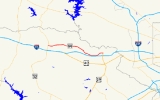
Maryland Route 99 is a state highway
in the U.S. state of Maryland
. Known as Old Frederick Road, the state highway runs 7.57 miles (12.2 km) from MD 32
near West Friendship
east to U.S. Route 29
(US 29) in Ellicott City
. MD 99 parallels the north side of Interstate 70
(I-70) through a rural and suburban area in northeastern Howard County
. MD 99, which follows the original 18th century road west from Baltimore, was constructed as part of three state highways: MD 99, the original MD 100, and MD 105. All three highways were constructed between the early 1920s and early 1930s. MD 99 originally turned south along St. Johns Lane to US 40
and MD 144
; in 1956, the state highway was rerouted along part of MD 100 and all of MD 105 to downtown Ellicott City. MD 99's eastern terminus was rolled back to US 29 in two steps in the late 1970s and late 1980s.
. MD 99 immediately intersects the old alignment of MD 32, which is unsigned MD 851J
and named Butterfly Court. The state highway mostly follows the height of land between the watersheds of the Patapsco River
to the north and the Patuxent River
to the south. MD 99 passes through the communities of Alpha, which is home to Marriotts Ridge High School
, and Henryton Heights
, which contains Alpha Ridge Community Park. Continuing east, the state highway intersects a pair of county highways, Marriottsville Road and Woodstock Road. Marriottsville Road heads north toward the village of Marriottsville on the Patapsco River and south to junctions with I-70 and US 40. Woodstock Road heads north to the village of Woodstock
, also on the Patapsco River, where the highway becomes MD 125.
East of Woodstock Road, MD 99 crosses Davis Branch and enters a suburban area on the north side of Ellicott City. The state highway begins to parallel I-70 as it intersects Bethany Lane. MD 99 meets St. John's Lane, its original alignment, at the entrance to Mt. Hebron High School. MD 99 intersects Mt. Hebron Drive, which heads north toward the historic home Elmonte
, before reaching its eastern terminus at the northern terminus of US 29 (Columbia Pike). US 29 heads south as a freeway through an interchange with I-70 toward Columbia
and Washington
. The roadway continues east as county-maintained Rogers Avenue, which curves south toward the historic downtown
of Ellicott City. Before Rogers Avenue crosses I-70, another section of Old Frederick Road splits to the east toward Baltimore County
, the historic home Linnwood
, and the historic Daniels Mill
on the Patapsco River.
that connects Ellicott City and Glen Burnie
, was assigned to Old Frederick Road east of St. Johns Lane. In addition, MD 105 was assigned to Rogers Avenue, which would later become part of MD 99. The first section of what was to become MD 99 was constructed as a 9 feet (2.7 m) wide macadam road along St. Johns Lane from Frederick Road north to Old Frederick Road by 1915.
By 1923, Old Frederick Road from St. Johns Lane west to Marriottsville Road was paved in concrete and Old Frederick Road from a place called Wheelwrights Gate near the modern US 29 intersection to the Baltimore County line at the Patapsco River was reconstructed as a macadam road. Rogers Avenue was paved as a concrete road from Frederick Road near downtown Ellicott City north to near its present intersection with US 40 in 1923. Rogers Avenue was completed north to Old Frederick Road in 1924 and 1925. The next section of MD 99 to be built was a concrete road from MD 32 to Henryton Road between 1924 and 1926. This road was part of a highway to connect Slacks Corner with Henryton
on the Patapsco River; Henryton Road later became part of MD 101. The gap between Henryton Road and Marriottsville Road was closed when a concrete road was constructed in 1929. Construction began shortly after 1930 on the gap between St. Johns Lane and Wheelwrights Gate; MD 100 was completed when that section of Old Frederick Road was paved in concrete by 1933.
In 1956, St. Johns Lane and Old Frederick Road east of Rogers Avenue were removed from the state highway system, resulting in the elimination of MD 100 and MD 105. MD 99 was extended east along Old Frederick Road and south along Rogers Avenue to Frederick Road. Rogers Avenue had been reconstructed and widened to 24 feet (7.3 m) starting in 1953, shortly before it became part of MD 99. I-70 north of Ellicott City and US 29 from US 40 to MD 99 were constructed between 1964 and 1967. MD 99 was relocated between US 29 and south of I-70 around 1966 when the state highway's bridge over I-70 was built; two sections of old alignment became segments of MD 985. MD 99's eastern terminus was rolled back from Frederick Road to US 40 in 1978 and from US 40 to its present terminus at US 29 in 1989.
.
{| class=wikitable
!Location
!Mile
!Destinations
!Notes
|-
|West Friendship
|0.00
|
|Western terminus
|-
|rowspan=2|Woodstock
|2.87
|Marriottsville Road to
|
|-
|3.72
|Woodstock Road north to
|
|-
|Ellicott City
|7.57
|
|Eastern terminus; northern terminus of US 29
State highway
State highway, state road or state route can refer to one of three related concepts, two of them related to a state or provincial government in a country that is divided into states or provinces :#A...
in the U.S. state of Maryland
Maryland
Maryland is a U.S. state located in the Mid Atlantic region of the United States, bordering Virginia, West Virginia, and the District of Columbia to its south and west; Pennsylvania to its north; and Delaware to its east...
. Known as Old Frederick Road, the state highway runs 7.57 miles (12.2 km) from MD 32
Maryland Route 32
Maryland Route 32 is a state highway in the U.S. state of Maryland. The state highway runs from Interstate 97 and MD 3 in Millersville west and north to Washington Road in Westminster. The east–west portion of MD 32 is the Patuxent Freeway, a four- to six-lane...
near West Friendship
West Friendship, Maryland
West Friendship is an affluent semi-rural community in western Howard County, Maryland. West Friendship is located at the junction of Interstate 70/U.S. Highway 40/Maryland Route 144 and Maryland Route 32.- History :...
east to U.S. Route 29
U.S. Route 29 in Maryland
U.S. Route 29 is a north–south United States highway that runs for from the western suburbs of Baltimore, Maryland, to Pensacola, Florida. In the U.S. state of Maryland, US 29 is a major highway that emerges from Washington D.C. and runs north into eastern Montgomery County, stretching...
(US 29) in Ellicott City
Ellicott City, Maryland
Ellicott City is an unincorporated community and census-designated place in Howard County, Maryland, United States. It is part of the Baltimore-Washington Metropolitan Area. The population was 65,834 at the 2010 census. It is the county seat of Howard County...
. MD 99 parallels the north side of Interstate 70
Interstate 70 in Maryland
Interstate 70 is a part of the Interstate Highway System that runs from Cove Fort, Utah to Baltimore, Maryland. In Maryland, the Interstate Highway runs from the Pennsylvania state line in Hancock east to the Interstate's eastern terminus near its junction with I-695 at a park and ride in...
(I-70) through a rural and suburban area in northeastern Howard County
Howard County, Maryland
-2010:Whereas according to the 2010 U.S. Census Bureau:*62.2% White*17.5% Black*0.3% Native American*14.4% Asian*0.0% Native Hawaiian or Pacific Islander*3.6% Two or more races*2.0% Other races*5.8% Hispanic or Latino -2000:...
. MD 99, which follows the original 18th century road west from Baltimore, was constructed as part of three state highways: MD 99, the original MD 100, and MD 105. All three highways were constructed between the early 1920s and early 1930s. MD 99 originally turned south along St. Johns Lane to US 40
U.S. Route 40 in Maryland
U.S. Route 40 in the U.S. state of Maryland runs from western Maryland to Cecil County in the state's northeastern corner. With a total length of over , it is the longest numbered highway in Maryland. Almost half of the road overlaps with Interstate 68 or Interstate 70, while the old alignment...
and MD 144
Maryland Route 144
Maryland Route 144 is a collection of state highways in the U.S. state of Maryland. These highways are sections of old alignment of U.S. Route 40 between Cumberland and Baltimore...
; in 1956, the state highway was rerouted along part of MD 100 and all of MD 105 to downtown Ellicott City. MD 99's eastern terminus was rolled back to US 29 in two steps in the late 1970s and late 1980s.
Route description
MD 99 begins at an intersection with MD 32 (Sykesville Road) at Slacks Corner a short distance north of MD 32's interchange with I-70 in West Friendship. Old Frederick Road continues west as a county highway that parallels the north side of I-70 west to Twin Arch Road near Mount AiryMount Airy, Maryland
Mount Airy is a town in Carroll, Frederick, Howard, and Montgomery counties in the U.S. state of Maryland.-Geography:According to the United States Census Bureau, the town has a total area of , all of it land.-History:...
. MD 99 immediately intersects the old alignment of MD 32, which is unsigned MD 851J
Maryland Route 851
Maryland Route 851 is a state highway in the U.S. state of Maryland. The state highway runs as a north–south highway between junctions with MD 32 in Sykesville. MD 851 is the old alignment of MD 32 through Sykesville, which was paved by 1910. The state highway was designated when the MD...
and named Butterfly Court. The state highway mostly follows the height of land between the watersheds of the Patapsco River
Patapsco River
The Patapsco River is a river in central Maryland which flows into Chesapeake Bay. The river's tidal portion forms the harbor for the city of Baltimore...
to the north and the Patuxent River
Patuxent River
The Patuxent River is a tributary of the Chesapeake Bay in the state of Maryland. There are three main river drainages for central Maryland: the Potomac River to the west passing through Washington D.C., the Patapsco River to the northeast passing through Baltimore, and the Patuxent River between...
to the south. MD 99 passes through the communities of Alpha, which is home to Marriotts Ridge High School
Marriotts Ridge High School
Marriotts Ridge High School is a secondary school located in Marriottsville, Maryland. It is part of the Howard County Public School System. It is known for academic excellence, character growth, and its athletic teams...
, and Henryton Heights
Henryton Heights, Maryland
Henryton Heights is an unincorporated community in Howard County, Maryland, United States.-References:...
, which contains Alpha Ridge Community Park. Continuing east, the state highway intersects a pair of county highways, Marriottsville Road and Woodstock Road. Marriottsville Road heads north toward the village of Marriottsville on the Patapsco River and south to junctions with I-70 and US 40. Woodstock Road heads north to the village of Woodstock
Woodstock, Maryland
Woodstock is an unincorporated community which is a suburb of Baltimore, Maryland. The original village of Woodstock is located in Howard County, but the surrounding area includes portions of Baltimore County and Carroll County.- Demographics :...
, also on the Patapsco River, where the highway becomes MD 125.
East of Woodstock Road, MD 99 crosses Davis Branch and enters a suburban area on the north side of Ellicott City. The state highway begins to parallel I-70 as it intersects Bethany Lane. MD 99 meets St. John's Lane, its original alignment, at the entrance to Mt. Hebron High School. MD 99 intersects Mt. Hebron Drive, which heads north toward the historic home Elmonte
Elmonte
Elmonte, also known as Twilford, is a historic home located at Ellicott City, Howard County, Maryland, United States. It is a -story country house, built of random ashlar granite in the Italian villa style, and is thought to have been completed in 1858. To the rear of the mansion is a stuccoed...
, before reaching its eastern terminus at the northern terminus of US 29 (Columbia Pike). US 29 heads south as a freeway through an interchange with I-70 toward Columbia
Columbia, Maryland
Columbia is a planned community that consists of ten self-contained villages, located in Howard County, Maryland, United States. It began with the idea that a city could enhance its residents' quality of life. Creator and developer James W. Rouse saw the new community in terms of human values, not...
and Washington
Washington, D.C.
Washington, D.C., formally the District of Columbia and commonly referred to as Washington, "the District", or simply D.C., is the capital of the United States. On July 16, 1790, the United States Congress approved the creation of a permanent national capital as permitted by the U.S. Constitution....
. The roadway continues east as county-maintained Rogers Avenue, which curves south toward the historic downtown
Ellicott City Historic District
Ellicott City Historic District is a national historic district in Ellicott City, Howard County, Maryland. It may include Doughoregan Manor and/or Ellicott City Station, which are two National Historic Landmarks in Ellicott City....
of Ellicott City. Before Rogers Avenue crosses I-70, another section of Old Frederick Road splits to the east toward Baltimore County
Baltimore County, Maryland
Baltimore County is a county located in the northern part of the US state of Maryland. In 2010, its population was 805,029. It is part of the Baltimore-Washington Metropolitan Area. Its county seat is Towson. The name of the county was derived from the barony of the Proprietor of the Maryland...
, the historic home Linnwood
Linnwood (Ellicott City, Maryland)
Linnwood, is a historic home located at Ellicott City, Howard County, Maryland, United States. It is a large 1901 Queen Anne-influenced house consisting of a -story four-bay by four-bay frame structure with vinyl siding, a rubble stone foundation, and a hip roof with asphalt shingles...
, and the historic Daniels Mill
Daniels Mill
Daniels Mill may refer to:*Daniels Mill, Shropshire, a watermill near Bridgnorth in the English county of Shropshire* Daniels Mill , a place on the List of Registered Historic Places in the US state of Maryland...
on the Patapsco River.
History
Old Frederick Road was the original 18th century highway between Baltimore and the Mount Airy area. The highway, which was mostly built along the height of land between the Patapsco and Patuxent watersheds, was replaced by the more southern Baltimore and Fredericktown Turnpike, which is now MD 144, around 1812. In the 20th century, the portion of Old Frederick Road east of West Friendship became part of two state highways. MD 99 was assigned to St. Johns Lane north of Frederick Road (formerly US 40 and MD 144) and Old Frederick Road from St. Johns Lane to Slacks Corner. The original MD 100, as opposed to the modern freewayMaryland Route 100
Maryland Route 100 is a major east–west highway connecting U.S. Route 29 in Ellicott City and MD 177 in Pasadena. MD 100 also connects to Interstate 95 , US 1, the Baltimore-Washington Parkway , and I-97...
that connects Ellicott City and Glen Burnie
Glen Burnie, Maryland
Glen Burnie is a census-designated place in Anne Arundel County, Maryland, United States, and is a suburb of Baltimore. The population was 67,639 at the 2010 census...
, was assigned to Old Frederick Road east of St. Johns Lane. In addition, MD 105 was assigned to Rogers Avenue, which would later become part of MD 99. The first section of what was to become MD 99 was constructed as a 9 feet (2.7 m) wide macadam road along St. Johns Lane from Frederick Road north to Old Frederick Road by 1915.
By 1923, Old Frederick Road from St. Johns Lane west to Marriottsville Road was paved in concrete and Old Frederick Road from a place called Wheelwrights Gate near the modern US 29 intersection to the Baltimore County line at the Patapsco River was reconstructed as a macadam road. Rogers Avenue was paved as a concrete road from Frederick Road near downtown Ellicott City north to near its present intersection with US 40 in 1923. Rogers Avenue was completed north to Old Frederick Road in 1924 and 1925. The next section of MD 99 to be built was a concrete road from MD 32 to Henryton Road between 1924 and 1926. This road was part of a highway to connect Slacks Corner with Henryton
Henryton, Maryland
Henryton is an unincorporated community in Carroll County, Maryland, United States.-References:...
on the Patapsco River; Henryton Road later became part of MD 101. The gap between Henryton Road and Marriottsville Road was closed when a concrete road was constructed in 1929. Construction began shortly after 1930 on the gap between St. Johns Lane and Wheelwrights Gate; MD 100 was completed when that section of Old Frederick Road was paved in concrete by 1933.
In 1956, St. Johns Lane and Old Frederick Road east of Rogers Avenue were removed from the state highway system, resulting in the elimination of MD 100 and MD 105. MD 99 was extended east along Old Frederick Road and south along Rogers Avenue to Frederick Road. Rogers Avenue had been reconstructed and widened to 24 feet (7.3 m) starting in 1953, shortly before it became part of MD 99. I-70 north of Ellicott City and US 29 from US 40 to MD 99 were constructed between 1964 and 1967. MD 99 was relocated between US 29 and south of I-70 around 1966 when the state highway's bridge over I-70 was built; two sections of old alignment became segments of MD 985. MD 99's eastern terminus was rolled back from Frederick Road to US 40 in 1978 and from US 40 to its present terminus at US 29 in 1989.
Junction list
The entire route is in Howard CountyHoward County, Maryland
-2010:Whereas according to the 2010 U.S. Census Bureau:*62.2% White*17.5% Black*0.3% Native American*14.4% Asian*0.0% Native Hawaiian or Pacific Islander*3.6% Two or more races*2.0% Other races*5.8% Hispanic or Latino -2000:...
.
{| class=wikitable
!Location
!Mile
!Destinations
!Notes
|-
|West Friendship
West Friendship, Maryland
West Friendship is an affluent semi-rural community in western Howard County, Maryland. West Friendship is located at the junction of Interstate 70/U.S. Highway 40/Maryland Route 144 and Maryland Route 32.- History :...
|0.00
|
|Western terminus
|-
|rowspan=2|Woodstock
Woodstock, Maryland
Woodstock is an unincorporated community which is a suburb of Baltimore, Maryland. The original village of Woodstock is located in Howard County, but the surrounding area includes portions of Baltimore County and Carroll County.- Demographics :...
|2.87
|Marriottsville Road to
|
|-
|3.72
|Woodstock Road north to
|
|-
|Ellicott City
Ellicott City, Maryland
Ellicott City is an unincorporated community and census-designated place in Howard County, Maryland, United States. It is part of the Baltimore-Washington Metropolitan Area. The population was 65,834 at the 2010 census. It is the county seat of Howard County...
|7.57
|
|Eastern terminus; northern terminus of US 29