

List of rapids of the Columbia River
Encyclopedia
This is a list of rapid
s of the Columbia River
, listed in upriver order. Almost all of these rapids are now submerged in the reservoirs of dams. The list is not exhaustive; there were numerous minor rapids and riffles, many of which were never named.
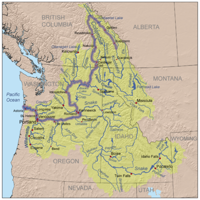
Mouth to Snake River
) "has the slowest current of any part of the Columbia above The Dalles".
Revelstoke to Mica Dam
Mica Dam to source at Columbia Lake
Rapid
A rapid is a section of a river where the river bed has a relatively steep gradient causing an increase in water velocity and turbulence. A rapid is a hydrological feature between a run and a cascade. A rapid is characterised by the river becoming shallower and having some rocks exposed above the...
s of the Columbia River
Columbia River
The Columbia River is the largest river in the Pacific Northwest region of North America. The river rises in the Rocky Mountains of British Columbia, Canada, flows northwest and then south into the U.S. state of Washington, then turns west to form most of the border between Washington and the state...
, listed in upriver order. Almost all of these rapids are now submerged in the reservoirs of dams. The list is not exhaustive; there were numerous minor rapids and riffles, many of which were never named.
Mouth to Snake RiverSnake RiverThe Snake is a major river of the greater Pacific Northwest in the United States. At long, it is the largest tributary of the Columbia River, the largest North American river that empties into the Pacific Ocean...
- Cascade Rapids (The Cascades, Grand Rapids, Cascade Falls, Cascades of the Columbia): Located at river mileRiver mileIn the United States, a River mile is a measure of distance in miles along a river from its mouth. River mile numbers begin at zero and increase further upstream. The corresponding metric unit using kilometers is the River kilometer...
146.5 near today's Bonneville DamBonneville DamBonneville Lock and Dam consists of several run-of-the-river dam structures that together complete a span of the Columbia River between the U.S. states of Oregon and Washington at River Mile 146.1. The dam is located east of Portland, Oregon, in the Columbia River Gorge. The primary functions of...
in the Columbia River GorgeColumbia River GorgeThe Columbia River Gorge is a canyon of the Columbia River in the Pacific Northwest of the United States. Up to deep, the canyon stretches for over as the river winds westward through the Cascade Range forming the boundary between the State of Washington to the north and Oregon to the south...
; at 45°38′34"N 121°56′4"W. The river fell about 40 feet (12.2 m) over approximately 2 miles (3.2 km), through a channel about 150 yards (137.2 m) wide. Submerged in 1937 under Lake BonnevilleLake Bonneville (Oregon)Lake Bonneville is a reservoir on the Columbia River in the U.S. states of Oregon and Washington. It was created in 1937 with the construction of Bonneville Dam. The reservoir stretches between it and The Dalles Dam, upstream. It lies in parts of three counties in Oregon and two in Washington ....
, the reservoir of Bonneville Dam. See also Bridge of the Gods, Cascade Locks and CanalCascade Locks and CanalThe Cascade Locks and Canal was a navigation project on the Columbia River between the U.S. states of Oregon and Washington, completed in 1896. It allowed the steamboats of the Columbia River to bypass the Cascades Rapids, and thereby opened a passage from the lower parts of the river as far as The...
, Greenleaf PeakGreenleaf PeakGreenleaf Peak is a mountain in the Cascade Range in the U.S. state of Washington, located on the north side of the Columbia River near Table Mountain, in the Columbia River Gorge. The peak lies within the Columbia River Gorge National Scenic Area near Bonneville Dam. It is in elevation...
, and Table Mountain.
- Celilo FallsCelilo FallsCelilo Falls was a tribal fishing area on the Columbia River, just east of the Cascade Mountains, on what is today the border between the U.S. states of Oregon and Washington...
and The Dalles (many variant names including: The Chutes, Columbia Falls, Great Falls of the Columbia, Five Mile Rapids, Long Narrows, Les Grand Dalles de la Columbia, The Dalles of the Columbia): A series of rapids located between river mile 188 and 200 near today's The Dalles, OregonThe Dalles, OregonThe Dalles is the largest city and county seat of Wasco County, Oregon, United States. The name of the city comes from the French word dalle The Dalles is the largest city and county seat of Wasco County, Oregon, United States. The name of the city comes from the French word dalle The Dalles is...
in the Columbia River Gorge. The entire set of rapids was known by various names such as The Dalles and The Narrows. The river fell about 81 feet (24.7 m) over approximately 12 miles (19.3 km), through a channel that narrowed to 75 feet (22.9 m) wide in one section. Rapids and falls within the series included (in order upriver): Threemile Rapids, 45°36′29"N 121°8′44"W, The Dalles Rapids (not to be confused with the whole series of rapids), 45°37′44"N 121°6′49"W; Fivemile Rapids, 45°37′49"N 121°6′29"W; Tenmile Rapids, 45°39′1"N 121°2′19"W;, and Celilo Falls, 45°38′59"N 120°58′44"W;. Except for Threemile Rapids, the entire series of rapids was submerged in 1957 under Lake CeliloLake CeliloLake Celilo is a long reservoir on the Columbia River in the United States, between the U.S. states of Washington and Oregon. It was created in 1957 with the construction of The Dalles Dam near The Dalles, Oregon, and stretches upstream to the John Day Dam. Its filling drowned the former site of...
, the reservoir of The Dalles Dam. Threemile Rapids is just below the dam, at the upper end of Lake Bonneville, the reservoir of Bonneville Dam. See also Celilo CanalCelilo CanalCelilo Canal was a canal connecting two points of the Columbia River between the states of Oregon and Washington, U.S. just east of The Dalles....
, Celilo Village, OregonCelilo Village, OregonCelilo Village, Oregon is an unincorporated Native American community on the Columbia River in northeastern Wasco County in the U.S. state of Oregon. It is near Lake Celilo, the former site of Celilo Falls; it is just south of the community of Wishram, Washington, across the Columbia River.In 2003...
, and Wishram villageWishram villageWishram Village, referred to as nixlúidix by its residents, was a summer and winter village on the Columbia River occupied by Upper Chinook people. It is considered the largest prehistoric Chinook village site. The site is now part of Columbia Hills State Park.-History:Located near Five Mile...
.
- Preachers Eddy: Located at river mile 214, 45°42′14"N 120°43′24"W, near Rufus, OregonRufus, OregonRufus is a city in Sherman County, Oregon, United States. The population was 268 at the 2000 census. The city was named for an early settler, Rufus Carrol Wallis.-Geography:...
.
- Schofield Rapids: Located at river mile 215, just below today's John Day DamJohn Day DamThe John Day Dam is a concrete gravity run-of-the-river dam spanning the Columbia River in the northwestern United States. The dam features a navigation lock plus fish ladders on both sides. The John Day Lock has the highest lift of any U.S. lock...
; at 45°42′39"N 120°42′4"W. It was small and not a significant hazard. It was submerged in 1957 by the uppermost waters of Lake Celilo, the reservoir of The Dalles Dam.
- John Day Rapids: Located between river mile 216 and 218, near the mouth of the John Day RiverJohn Day RiverThe John Day River is a tributary of the Columbia River, approximately long, in northeastern Oregon in the United States. Undammed along its entire length, the river is the third longest free-flowing river in the conterminous United States. There is extensive use of its waters for irrigation. Its...
and consisting of two main rapids: the Lower John Day Rapids, at 45°42′59"N 120°41′9"W, and the Upper John Day Rapids, at 45°44′9"N 120°39′24"W. The Army Corps of Engineers made efforts to improve navigation at the rapids. In 1911 a "large reef" was removed from the "middle rapids". The rapids were submerged in 1971 under Lake UmatillaLake UmatillaLake Umatilla is a long reservoir on the Columbia River in the United States, between the U.S. states of Washington and Oregon. It was created in 1971 with the construction of John Day Dam, and stretches upstream to the McNary Dam. It lies in parts of Sherman, Gilliam, Morrow, and Umatilla...
, the reservoir of John Day Dam.
- Indian Rapids: Located at river mile 220, just above the mouth of the John Day River, at 45°44′34"N 120°37′4"W. It was small and not a significant hazard. When David Thompson visited the rapids on August 2, 1811, he named it Muscle Rapids due to the many shells he found there. The rapids were submerged in 1971 under Lake Umatilla, the reservoir of John Day Dam.
- Squally Hook Rapids: Located at river mile 223, a few miles above the mouth of the John Day River, at 45°43′54"N 120°33′19"W.. It was not a major hazard although one commentator described it as "short sharp and savage". In 1912 the Army Corps of Engineers improved navigation by drilling and blasting rocks at the rapids. The rapids were submerged in 1971 under Lake Umatilla, the reservoir of John Day Dam.
- Rock Creek Rapids: Located near the mouth of Rock Creek, approximately river mile 227 to 228. Described as "rough and rowdy" but not particularly hazardous.
- Blalock Rapids: A very minor rapid, probably located near the railway siding of Blalock at the mouth of Blalock Canyon, approximate river mile 233. It was submerged in 1971 under Lake Umatilla, the reservoir of John Day Dam.
- Owyhee Rapids: A very minor rapid located at river mile 240, 45°43′24"N 120°13′59"W, near Arlington, OregonArlington, OregonArlington is a city in Gilliam County, Oregon, United States. The account of how this city received its name varies: one tradition claims it was named after the lawyer Nathan Arlington Cornish; another tradition claims that the Southern inhabitants of this city had enough clout to rename the city...
. It was submerged in 1971 under Lake Umatilla, the reservoir of John Day Dam.
- Canoe Encampement Rapids: A minor rapid located at river mile 265.5, 45°50′47"N 119°46′34"W, about 3 miles (4.8 km) below Boardman, OregonBoardman, OregonBoardman is a city in Morrow County, Oregon, United States on the Columbia River and Interstate 84. As of the 2010 census the population was 3,220. It is part of the Pendleton–Hermiston Micropolitan Statistical Area.-History:...
. In 1912 the Army Corps of Engineers improved navigation at the rapids by removing "two large reefs" and several smaller ones from the center of the channel, which had been a hazard during low-water. The rapids were submerged in 1971 under Lake Umatilla, the reservoir of John Day Dam.
- Umatilla Rapids: A significant rapid, located at what is now McNary DamMcNary DamMcNary Dam is a 1.4-mile long concrete gravity run-of-the-river dam which spans the Columbia River. It joins Umatilla County, Oregon with Benton County, Washington, 292 miles upriver from the mouth of the Columbia at Astoria, Oregon. It is operated by the U.S. Army Corps of Engineers' McNary...
, river mile 292, 45°56′17"N 119°18′9"W. There were at least three "riffles", with the third one downstream being the main one. The total length was somewhat over 1.5 miles (2.4 km). During the low-water seasons, about November to March, Umatilla Rapids became a barrier to steamboat navigation in the late 19th century. The lesser rapids below Umatilla also became more hazardous; larger boats might not even be able to reach Umatilla Rapids during low-water. During high-water large boats could operate from Celilo Falls upriver as far as Lewiston, IdahoLewiston, IdahoLewiston is a city in and also the county seat of Nez Perce County in the Pacific Northwest state of Idaho. It is the second-largest city in the northern Idaho region, behind Coeur d'Alene and ninth-largest in the state. Lewiston is the principal city of the Lewiston, ID - Clarkston, WA...
on the Snake River. The low-water season effectively suspended river navigation above Umatilla Rapids and on the Snake River. In 1912 the Army Corps of Engineers described the Upper Umatilla Rapids as having two channels. The north channel, known as the low-water channel, was "narrow and tortuous at low water, but has been the only available channel". The south channel, known as the high-water channel, was used only during the high and medium stages of the river. In 1891 rocks were blasted in Umatilla Rapids to create a passage for steamboats during low water. Additional work to improve navigation was done in 1910 and 1911. The rapids were submerged in 1954 under Lake WallulaLake WallulaLake Wallula is a reservoir on the Columbia River in the United States, between the U.S. states of Washington and Oregon. It was created in 1954 with the construction of McNary Dam. It reaches from McNary Dam near the city of Umatilla, Oregon, to the Tri-Cities of Washington.-See also:* Wallula...
, the reservoir of McNary DamMcNary DamMcNary Dam is a 1.4-mile long concrete gravity run-of-the-river dam which spans the Columbia River. It joins Umatilla County, Oregon with Benton County, Washington, 292 miles upriver from the mouth of the Columbia at Astoria, Oregon. It is operated by the U.S. Army Corps of Engineers' McNary...
. Parts of the dam were built on top of the lower portion of the rapids. In 1805 the Lewis and Clark Expedition gave the name Musselshell Rapids due to the numerous mussels.
- Homley Rapids (Homly Rapids): A very minor rapid located about 7 miles (11.3 km) below Pasco, WashingtonPasco, WashingtonPasco is a city in and the county seat of Franklin County, Washington, United States.Pasco is one of three cities that make up the Tri-Cities region of the state of Washington...
. In 1911 the Army Corps of Engineers described "Homly Rapids" as "the shoalest on the Columbia between Celilo and the mouth of the Snake River", and that the river was divided by numerous islands, with the main channel passing between "islands Nos. 4 and 5". The Corps made efforts to improve navigation by removing obstructions from the main channel and by building "wing dams" to force more water into the main channel. The rapids were submerged in 1954 under Lake Wallula, the reservoir of McNary Dam.
- Bull Run Rapids: A very minor rapid located a few miles below Wallula GapWallula GapWallula Gap is a large water gap of the Columbia River through basalt anticlines in the Columbia River Basin in the U.S. state of Washington, just south of the confluence of the Walla Walla and Columbia rivers...
.
Snake River to Bridgeport
The 70 mile stretch between Priest Rapids and the mouth of the Snake River (the Hanford ReachHanford Reach
The Hanford Reach is a free-flowing section of the Columbia River, about long, in eastern Washington state, named after a large northward bend in the river's otherwise southbound course. It is the only section of the Columbia in the U.S...
) "has the slowest current of any part of the Columbia above The Dalles".
- Coyote Rapids: A minor rapid located at river mile 382, 46°38′57"N 119°37′8"W, next to the "100 Area" of the Hanford SiteHanford SiteThe Hanford Site is a mostly decommissioned nuclear production complex on the Columbia River in the U.S. state of Washington, operated by the United States federal government. The site has been known by many names, including Hanford Works, Hanford Engineer Works or HEW, Hanford Nuclear Reservation...
, which is home to Hanford's B Reactor (now a National Historic LandmarkNational Historic LandmarkA National Historic Landmark is a building, site, structure, object, or district, that is officially recognized by the United States government for its historical significance...
) and N-ReactorN-ReactorThe N-Reactor was a graphite-moderated nuclear reactor constructed during the Cold War and operated by the U.S. government at the Hanford Site in Washington....
, and others including the C, D, DR, KE, and KW reactors. As part of the Hanford ReachHanford ReachThe Hanford Reach is a free-flowing section of the Columbia River, about long, in eastern Washington state, named after a large northward bend in the river's otherwise southbound course. It is the only section of the Columbia in the U.S...
of the Columbia, Coyote Rapids still exist.
- Priest RapidsPriest RapidsPriest Rapids was a narrow, fast-flowing stretch of the Columbia River, located in the central region of the U.S. state of Washington. It was flooded by the construction of the Priest Rapids Dam in the 1950s....
: A series of seven rapids located approximately between river mile 406 and 397 (an 1893 report says river miles 409.5 to 421), near MattawaMattawa, WashingtonMattawa is an incorporated city in Grant County, Washington, United States. The population was 2,609 at the 2000 census. An estimated population exists between 4500-6500 residents during peak fruit picking/agricultural season and subsides by approximately 2000 residents during non-picking...
, Desert AireDesert Aire, WashingtonDesert Aire is a census-designated place in Grant County, Washington, United States. Desert Aire's elevation is The population was 1,124 at the 2000 census.-Geography:Desert Aire is located at ....
, and the Yakima Training CenterYakima Training CenterThe Yakima Training Center is a United States Army training center located in south central Washington state. It is bounded on the west by Interstate 82, on the south by the city of Yakima, on the north by the city of Ellensburg and Interstate 90, and on the east by the Columbia River...
. The USGS provides a single coordinate point, 46°45′17"N 119°58′20"W. The river dropped 72 feet (21.9 m) over the entire 9 miles (14.5 km) length, with a drop of 20 feet (6.1 m) occurring in one short section. In 1888 two steamboats were built at PascoPasco, WashingtonPasco is a city in and the county seat of Franklin County, Washington, United States.Pasco is one of three cities that make up the Tri-Cities region of the state of Washington...
specifically for the purpose of making it through Priest Rapids and Rock Island Rapids to WenatcheeWenatchee, WashingtonWenatchee is located in North Central Washington and is the largest city and county seat of Chelan County, Washington, United States. The population within the city limits in 2010 was 31,925...
. The first of the two failed. The second, smaller one, City of Ellensburg, under Captain William Polk Gray, succeeded in passing through Priest Rapids and the more difficult Rock Island Rapids. Later, the sister boat, Thomas L. Nixon, also succeeded in ascending both rapids and reaching Wenatchee. In 1959 the rapids were submerged under Priest Rapids LakePriest Rapids LakePriest Rapids Lake is a reservoir on the Columbia River in the U.S. state of Washington. It was created in 1959 with the construction of Priest Rapids Dam. The reservoir stretches from there upstream to the Wanapum Dam....
, the reservoir of Priest Rapids Dam.
- Cabinet Rapids: Located at river mile 448, at the mouth of Moses CouleeMoses CouleeMoses Coulee cuts into the Waterville plateau in Douglas County, Washington. It is to the west of and roughly parallel to the more famous Grand Coulee...
, 47°16′17"N 120°5′29"W. The river fell about 10 feet (3 m) over a length of about 8000 feet (2,438.4 m). In 1963 the rapids were submerged under Lake WanapumLake WanapumWanapum Lake is a reservoir on the Columbia River in the U.S. state of Washington. It was created in 1963 with the construction of Wanapum Dam. It stretches from there upstream to the Rock Island Dam. The lake is named for the Wanapum people....
, the reservoir of Wanapum DamWanapum DamWanapum Dam is a hydroelectric project located on the Columbia River downstream from Vantage, Washington where Interstate 90 crosses the Columbia from Grant County into Kittitas County. It is owned by the Grant County Public Utility District. Its reservoir is named Lake Wanapum.The dam, and its...
.
- Nixon Rapids: Located at river mile 451.5, a few miles below Rock Island DamRock Island DamRock Island Dam is a hydroelectric dam on the Columbia River in the U.S. state of Washington. Chelan County Public Utility District's Rock Island Dam and Hydro Project was the first dam to span the Columbia, having been built from 1929 to 1933. It is located near the geographical center of...
; 47°19′12"N 120°5′19"W. The rapids are submerged in Lake WanapumLake WanapumWanapum Lake is a reservoir on the Columbia River in the U.S. state of Washington. It was created in 1963 with the construction of Wanapum Dam. It stretches from there upstream to the Rock Island Dam. The lake is named for the Wanapum people....
, the reservoir of Wanapum DamWanapum DamWanapum Dam is a hydroelectric project located on the Columbia River downstream from Vantage, Washington where Interstate 90 crosses the Columbia from Grant County into Kittitas County. It is owned by the Grant County Public Utility District. Its reservoir is named Lake Wanapum.The dam, and its...
.
- Rock Island Rapids: Located at approximately river mile 454, near Rock Island DamRock Island DamRock Island Dam is a hydroelectric dam on the Columbia River in the U.S. state of Washington. Chelan County Public Utility District's Rock Island Dam and Hydro Project was the first dam to span the Columbia, having been built from 1929 to 1933. It is located near the geographical center of...
and Rock IslandRock Island, WashingtonRock Island is a city in Douglas County, Washington, United States. It is part of the Wenatchee–East Wenatchee Metropolitan Statistical Area. The population was 863 at the 2000 census.-History:...
, and a few miles upriver from Cabinet Rapids; 47°20′39"N 120°5′52"W. The rapids were over 2 miles (3.2 km) long. Local native people called them Squah-ah-shee. They were given their present name in 1881 by Lieutenant Thomas W. Symons, who named them for Rock Island, a large rock in the river below Wenatchee, around which the water flowed swift and roughly. The two channels around Rock Island were full of rocks and other obstructions, and there was a "great reef" a short distance above the head of the island, with large bars of gravel, "nearly choking the channel at low water". The river fell 10 feet (3 m) over a distance of 3000 feet (914.4 m) at low-water. In 1933 the rapids were submerged in Rock Island PoolRock Island PoolRock Island Pool is a reservoir on the Columbia River in the U.S. state of Washington. It was created in 1933 with the construction of Rock Island Dam. The reservoir stretches from there upstream to the Rocky Reach Dam....
, the reservoir of Rock Island DamRock Island DamRock Island Dam is a hydroelectric dam on the Columbia River in the U.S. state of Washington. Chelan County Public Utility District's Rock Island Dam and Hydro Project was the first dam to span the Columbia, having been built from 1929 to 1933. It is located near the geographical center of...
. At least two steamboats were wrecked at the rapids. The Selkirk wrecked at Rock Island Rapids on May 15, 1906 (see Shipwrecks of the inland Columbia RiverShipwrecks of the inland Columbia RiverSteamboats on the Columbia River system were wrecked for many reasons, including striking rocks or logs , fire, boiler explosion, or puncture or crushing by ice. Sometimes boats could be salvaged, and sometimes not.-Collision:...
). In 1887 a steamboat tried and failed to ascend the Rock Island Rapids. In 1888 two steamboats were built at PascoPasco, WashingtonPasco is a city in and the county seat of Franklin County, Washington, United States.Pasco is one of three cities that make up the Tri-Cities region of the state of Washington...
specifically for the purpose of making it through Priest Rapids and Rock Island Rapids to WenatcheeWenatchee, WashingtonWenatchee is located in North Central Washington and is the largest city and county seat of Chelan County, Washington, United States. The population within the city limits in 2010 was 31,925...
. The first of the two failed. The second, smaller one, City of Ellensburg, under Captain William Polk Gray, succeeded in passing through Priest Rapids and the more difficult Rock Island Rapids. Later, the sister boat, Thomas L. Nixon, also succeeded in ascending both rapids and reaching Wenatchee.
- Entiat Rapids: Located between the mouth of the Entiat RiverEntiat RiverThe Entiat River is a tributary of the Columbia River, joining the Columbia near Entiat. The USGS lists two variant names for the Entiat River: En-ti-at-kwa River and Entiatqua River. En-ti-at-kwa is noted as being the original "Indian name", meaning "rapid water"...
and OrondoOrondo, WashingtonOrondo is an unincorporated community in Douglas County, Washington, United States. It is part of the Wenatchee–East Wenatchee Metropolitan Statistical Area. The population of the area although not a CDP is about 500....
, at approximately 47°39′30"N 120°13′0"W. The rapids are submerged in Lake EntiatLake EntiatLake Entiat is a reservoir between Chelan County and Douglas County in North Central Washington that is formed above Rocky Reach Dam , a hydroelectric dam on the Columbia River. The reservoir is north of Wenatchee and stretches upstream to the Wells Dam. Lincoln Rock State Park is on its east...
, the reservoir of Rocky Reach DamRocky Reach DamRocky Reach Dam is a hydroelectric dam in the U.S. state of Washington. Chelan County Public Utility District's Rocky Reach Dam and Hydro Project is located in north central Washington state, USA on the Columbia River, about seven miles upstream from the city of Wenatchee...
.
- Methow Rapids: Located at river mile 523, at the mouth of the Methow RiverMethow RiverThe Methow River is a tributary of the Columbia River in northern Washington in the United States. The river's watershed is , with a population of about 5,000 people. The Methow's watershed is characterized by relatively pristine habitats, with much of the river basin is located in national forests...
near PaterosPateros, WashingtonPateros is a city in Okanogan County, Washington, United States. The population was 643 at the 2000 census and increased 3.7% to 667 in the 2010 census.-History:Pateros was originally established as Ive's Landing in around 1886 by Lee Ives...
; 48°2′37"N 119°53′30"W. In 1967 the rapids were submerged in Lake PaterosLake PaterosLake Pateros is a reservoir on the Columbia River in the U.S. state of Washington. It was created in 1967 with the construction of Wells Dam. The reservoir lies almost entirely in Douglas and Okanogan counties, although the dam itself lies partially in the easternmost portion of Chelan County. The...
, the reservoir of Wells DamWells DamWells Dam is a hydroelectric dam located on the Columbia River, downstream from the confluence of the Okanogan River, Methow River, and the Columbia River in Washington State. The dam, associated structures, and machinery make up the Wells Hydroelectric Project. It is owned and operated by...
.
Bridgeport to Canadian border
The portion of the river between Monaghan Rapids and Foster Creek Rapids was regarded as particularly hazardous. An 1893 report by the Army Corps of Engineers described the river from Monaghan Rapids to the foot of Foster Creek Rapids as "very swift and studded with rocks, and taken all in all will be found an extremely hard and dangerous if not absolutely impassable portion of the river to navigate". Over the 45 miles (72.4 km) from Monaghan to Foster Creek the river fell 171 feet (52.1 m) at low-water. Over the 10 miles (16.1 km) between Mah-kin Rapids and a point three miles below Parson Rapids the river fell 41 feet (12.5 m) at low water. The portion from White Cap Rapids to Eagle Rapids was once known as "Nespilem Canyon". The Corps' 1893 report said that over the worst 3 miles (4.8 km) stretch the river fell 22 feet (6.7 m) at low-water and 24 feet (7.3 m) at high-water, and that the speed of the current at low-water was about 10 miles per hour (16.1 km/h). On the possibility of navigation the Corps was pessimistic: "The fall of the river here is so great that it is certain that no system of rock removal could make the river sufficiently navigable to justify the danger and risk necessarily incurred in running boats on it."- Reef Rapids: Located at river mile 544, between BridgeportBridgeport, WashingtonBridgeport is a city in Douglas County, Washington, United States. It is part of the Wenatchee–East Wenatchee Metropolitan Statistical Area. Bridgeport's population was 2,059 at the 2000 census.Bridgeport is located near the Chief Joseph Dam.-History:...
and Chief Joseph DamChief Joseph DamThe Chief Joseph Dam is a concrete gravity dam on the Columbia River, upriver from Bridgeport, Washington, USA. The dam was authorized as Foster Creek Dam and Powerhouse for power generation and irrigation by the River and Harbor Act of 1946...
; 48°0′10"N 119°39′27"W. It was submerged in 1967 by Lake PaterosLake PaterosLake Pateros is a reservoir on the Columbia River in the U.S. state of Washington. It was created in 1967 with the construction of Wells Dam. The reservoir lies almost entirely in Douglas and Okanogan counties, although the dam itself lies partially in the easternmost portion of Chelan County. The...
, the reservoir of Wells DamWells DamWells Dam is a hydroelectric dam located on the Columbia River, downstream from the confluence of the Okanogan River, Methow River, and the Columbia River in Washington State. The dam, associated structures, and machinery make up the Wells Hydroelectric Project. It is owned and operated by...
.
- Foster Creek Rapids: Located at river mile 547-546, just above Chief Joseph DamChief Joseph DamThe Chief Joseph Dam is a concrete gravity dam on the Columbia River, upriver from Bridgeport, Washington, USA. The dam was authorized as Foster Creek Dam and Powerhouse for power generation and irrigation by the River and Harbor Act of 1946...
and BridgeportBridgeport, WashingtonBridgeport is a city in Douglas County, Washington, United States. It is part of the Wenatchee–East Wenatchee Metropolitan Statistical Area. Bridgeport's population was 2,059 at the 2000 census.Bridgeport is located near the Chief Joseph Dam.-History:...
. About a mile long, the rapids are submerged in Rufus Woods Lake, the reservoir of Chief Joseph Dam. A 1893 report by the United States War Department described Foster Creek Rapids as "among the worst rapids on the river", and being about 3 miles (4.8 km) long, including Reef Rapids. Over this length the river fell 21 feet (6.4 m) during low water and 24 feet (7.3 m) at high water. In 1911 and 1912 efforts were made by the Army Corps of EngineersUnited States Army Corps of EngineersThe United States Army Corps of Engineers is a federal agency and a major Army command made up of some 38,000 civilian and military personnel, making it the world's largest public engineering, design and construction management agency...
to improve navigation by blasting submerged rocks and reefs from Reef Rapids through Foster Creek Rapids and upriver to "Kalichen Rock" (Eagle Rapids).
- Eagle Rapids (also called Whirlpool Rapids and Kalichen Falls): Located at river mile 555, just below Box Canyon; 48°4′49"N 119°29′26"W. Submerged in Rufus Woods Lake, the reservoir of Chief Joseph Dam.
- Long Rapids: Located at river mile 557, just above Box Canyon; 48°4′43"N 119°26′40"W. Submerged in Rufus Woods Lake, the reservoir of Chief Joseph Dam.
- White Cap Rapids: Located at river mile 558.5, between Gaviota Bend and Box Canyon; 48°3′50"N 119°25′29"W. Submerged in Rufus Woods Lake, the reservoir of Chief Joseph Dam. Lewis R. FreemanLewis R. FreemanLewis Ransome Freeman was an American explorer, journalist and war correspondent who wrote over twenty books chronicling his many travels, as well as numerous articles.-Biography:...
described White Cap Rapids as a narrow, straight, and steep channel "heavily littered with boulders and fanged with outcropping bedrock", with a "mad tumble of wallowing waters", somewhat similar to Gordon Rapids in the Big Bend region, but rougher.
- Parson Rapids: Located at river mile 566, at Tombstone Rocks, a few miles below Goose Flats; 48°5′54"N 119°19′33"W. Submerged in Rufus Woods Lake, the reservoir of Chief Joseph Dam.
- Granite Rapids: Located at river mile 570, south of Saddle Horse Flat; 48°6′11"N 119°15′43"W. Submerged in Rufus Woods Lake, the reservoir of Chief Joseph Dam.
- Mah-kin Rapids (also Mahkin): Located at river mile 572.5, at the head of Nespelem Canyon;48°6′59"N 119°13′1"W. Submerged in Rufus Woods Lake, the reservoir of Chief Joseph Dam.
- Nespelem Rapids: Located at river mile 582.5, just above the mouth of the Nespelem RiverNespelem RiverThe Nespelem River is a northern tributary of the Columbia River, in the U.S. state of Washington. It is completely contained within Okanogan County and the Colville Indian Reservation....
; 48°7′15"N 119°2′12"W. Submerged in Rufus Woods Lake, the reservoir of Chief Joseph Dam.
- Equilibrium Rapids (Jumbo Rapids): Located at river mile 584.5, at Bailey Basin; 48°5′37"N 119°1′22"W. Submerged in Rufus Woods Lake, the reservoir of Chief Joseph Dam. The name "equilibrium" was given by Symons because there was a rock in the rapids that rolled back and forth in the current.
- Monaghan Rapids (Moneghan's Rapids, Buckley's Rapids): Located at river mile 587, just below an island called Buckley Bar.; 48°4′0"N 119°0′55"W. The name was given in 1881 by Lieutenant Thomas W. Symons, in honor of James Monaghan, who had encountered difficulties at the rapids in 1879-1880 attempting to bring rafts of supplies downriver to a military camp on the Okanogan River. Submerged in Rufus Woods Lake, the reservoir of Chief Joseph Dam.
- Hell Gate: A gorge and rapids located at river mile 619, at the mouth of Hell Gate Canyon, 23 miles (37 km) upriver of Grand Coulee Dam; 47°56′13"N 118°36′14"W. Hellgate Island is located in Hell Gate Canyon. The rapids were submerged in 1942 under Franklin D. Roosevelt LakeFranklin D. Roosevelt LakeFranklin D. Roosevelt Lake is the reservoir created in 1941 by the impoundment of the Columbia River by the Grand Coulee Dam in Washington state. It is named for Franklin D. Roosevelt, who was President during the construction of the dam...
, the reservoir of Grand Coulee DamGrand Coulee DamGrand Coulee Dam is a gravity dam on the Columbia River in the U.S. state of Washington built to produce hydroelectric power and provide irrigation. It was constructed between 1933 and 1942, originally with two power plants. A third power station was completed in 1974 to increase its energy...
.
- Spokane Rapids: Located at the mouth of the Spokane RiverSpokane RiverThe Spokane River is a tributary of the Columbia River, approximately long, in northern Idaho and eastern Washington in the United States. It drains a low mountainous area east of the Columbia, passing through the city of Spokane, Washington.-Description:...
, at Columbia river mile 640. Submerged in 1942 under Franklin D. Roosevelt LakeFranklin D. Roosevelt LakeFranklin D. Roosevelt Lake is the reservoir created in 1941 by the impoundment of the Columbia River by the Grand Coulee Dam in Washington state. It is named for Franklin D. Roosevelt, who was President during the construction of the dam...
, the reservoir of Grand Coulee DamGrand Coulee DamGrand Coulee Dam is a gravity dam on the Columbia River in the U.S. state of Washington built to produce hydroelectric power and provide irrigation. It was constructed between 1933 and 1942, originally with two power plants. A third power station was completed in 1974 to increase its energy...
.
- Turtle Rapids: A minor rapid located approximately at river mile 670, near Bissell, above Stray Dog Canyon. The name comes from a number of rock outcroppings that resembled turtle backs.
- Rickey Rapids (also called Grand Rapids): These fairly hazardous rapids were located at river mile 697, 3 miles (4.8 km) south of the Colville River and Kettle FallsKettle Falls, WashingtonKettle Falls is a city in Stevens County, Washington, United States, named for the nearby Kettle Falls on the Columbia River, an ancient and important fishing site for Native Americans...
; 48°32′37"N 118°8′34"W. The rapids were dangerous enough that even small craft typically portaged around them. In 1826 they were given the name "Thompson Rapids" by David DouglasDavid DouglasDavid Douglas was a Scottish botanist. He worked as a gardener, and explored the Scottish Highlands, North America, and Hawaii, where he died.-Early life:...
in honor of David Thompson of the North West CompanyNorth West CompanyThe North West Company was a fur trading business headquartered in Montreal from 1779 to 1821. It competed with increasing success against the Hudson's Bay Company in what was to become Western Canada...
. The name "Rickey" was given by John Rickey, a man who operated a store near the rapids. The name "Grand Rapids was commonly used as late as 1882. Today the rapids are submerged in Franklin D. Roosevelt LakeFranklin D. Roosevelt LakeFranklin D. Roosevelt Lake is the reservoir created in 1941 by the impoundment of the Columbia River by the Grand Coulee Dam in Washington state. It is named for Franklin D. Roosevelt, who was President during the construction of the dam...
, the reservoir of Grand Coulee DamGrand Coulee DamGrand Coulee Dam is a gravity dam on the Columbia River in the U.S. state of Washington built to produce hydroelectric power and provide irrigation. It was constructed between 1933 and 1942, originally with two power plants. A third power station was completed in 1974 to increase its energy...
.
- Kettle FallsKettle FallsKettle Falls was an ancient and important salmon fishing site on the upper reaches of the Columbia River, in what is today the U.S. state of Washington, near the Canadian border...
: Located at river mile 704.5, about two miles below the mouth of the Kettle RiverKettle River (Columbia River)The Kettle River is a tributary of the Columbia River in northeastern Washington in the United States and southeastern British Columbia in Canada. Its drainage basin is large, of which are in Canada and in the United States.-Course:...
and five miles above the mouth of the Colville RiverColville River (Washington)The Colville River is a 60 mile long tributary of the Columbia River in northeastern Washington in the United States.-Course:The Colville River begins in southern Stevens County, Washington at the confluence of Sheep Creek and Deer Creek. It flows northwest past Colville and into the Columbia...
, near the city of Kettle FallsKettle Falls, WashingtonKettle Falls is a city in Stevens County, Washington, United States, named for the nearby Kettle Falls on the Columbia River, an ancient and important fishing site for Native Americans...
; 48°38′22"N 118°6′34"W. Submerged in Franklin D. Roosevelt Lake, the reservoir of Grand Coulee Dam.
- Little Dalles: Located at river mile 729, six miles downriver of NorthportNorthport, WashingtonNorthport is a town in Stevens County, Washington, United States. The population was 295 at the 2010 census.-History:Northport was given its name since it was once the northernmost town on the Spokane Falls and Northern Railway...
; 48°52′18"N 117°52′9"W. The river narrowed to 130 feet (39.6 m) at the head of the Little Dalles, then widened somewhat over a length of at least 2000 feet (609.6 m). Boat navigation through the Little Dalles was not difficult at low water, but during the high water season the drop increased to 20 feet (6.1 m), making it a major hazard. The Little Dalles presented the primary obstacle to navigation on the upper river into Canada. The river was constricted between massive stone cliffs. The first official use of the name "Little Dalles" appears to come from the 1881 report of Lieutenant Symons, although it is likely the name was informally used long before. In a 1893 report Symons described the Little Dalles at low-water as "placid", but at high-water as "a seething, whirling torrent, impelled forward by a 16-foot head". He recommended ways to improve navigation during low-water. To improve navigation during high-water would require extensive work and would still be hazardous. He wrote, "Trees and logs 60 or 70 feet in length disappear in Little Dalles at high water; they go right down on end and do not reappear". In 1942 the rapids were submerged in Franklin D. Roosevelt LakeFranklin D. Roosevelt LakeFranklin D. Roosevelt Lake is the reservoir created in 1941 by the impoundment of the Columbia River by the Grand Coulee Dam in Washington state. It is named for Franklin D. Roosevelt, who was President during the construction of the dam...
, the reservoir of Grand Coulee DamGrand Coulee DamGrand Coulee Dam is a gravity dam on the Columbia River in the U.S. state of Washington built to produce hydroelectric power and provide irrigation. It was constructed between 1933 and 1942, originally with two power plants. A third power station was completed in 1974 to increase its energy...
.
- Pingstone Rapids: Located 9 miles (14.5 km) above the mouth of the Kettle River, at approximately 48°43′30"N 118°3′0"W. The rapids are submerged in Franklin D. Roosevelt Lake, the reservoir of Grand Coulee Dam.
Canadian border to Revelstoke
- Waterloo Eddy: An eddy located at the mouth of Cai Creek, about 4 kilometres (2.5 mi) south of the Castlegar AirportCastlegar AirportThe West Kootenay Regional Airport, is a small regional airport located south southeast of Castlegar, British Columbia. Owned and operated by the City of Castlegar, YCG has a passenger terminal. Due to the mountainous terrain impinging on both runway approaches, there is no possibility of a...
, near Waterloo Road; 49°16′00"N 117°39′00"W.
- Kootenay Rapids (formerly called Tincup Rapids or Tin Cups): A minor rapid located 0.5 mile (0.80467 km) below Tincup Rapids, near CastlegarCastlegar, British ColumbiaCastlegar is the second largest city in the West Kootenay region of British Columbia, Canada. It is located within the Selkirk Mountains at the confluence of the Kootenay and Columbia Rivers. It is a regional trade and transportation centre, with a local economy fueled by forestry, mining and tourism...
, just below the mouth of the Kootenay RiverKootenay RiverThe Kootenay is a major river in southeastern British Columbia, Canada and the northern part of the U.S. states of Montana and Idaho. It is one of the uppermost major tributaries of the Columbia River, which is the largest North American river that empties into the Pacific Ocean...
. About 0.25 mile (0.402335 km) long, the rapids are mild.
- Tincup Rapids (formerly called Kootenay Rapids): A pair of rapids, called Upper and Lower, or Big and Little Tincup Rapids, located at CastlegarCastlegar, British ColumbiaCastlegar is the second largest city in the West Kootenay region of British Columbia, Canada. It is located within the Selkirk Mountains at the confluence of the Kootenay and Columbia Rivers. It is a regional trade and transportation centre, with a local economy fueled by forestry, mining and tourism...
, just above the mouth of the Kootenay RiverKootenay RiverThe Kootenay is a major river in southeastern British Columbia, Canada and the northern part of the U.S. states of Montana and Idaho. It is one of the uppermost major tributaries of the Columbia River, which is the largest North American river that empties into the Pacific Ocean...
; 49°19′N 117°39′W. The river narrows to 201 metres (659.4 ft) at the foot of the lower rapid. For steamboats, the rapids were a navigation hazard during low water in autumn and winter. In the 1890s efforts were made to improve the channel by blasting rocks in the river. The rapids were noted as a "strong rapid" by David ThompsonDavid Thompson (explorer)David Thompson was an English-Canadian fur trader, surveyor, and map-maker, known to some native peoples as "Koo-Koo-Sint" or "the Stargazer"...
in his journal entry of September 6, 1811. During the 19th century Tincup Rapids was called Kootenay Rapids, and what is today called Kootenay Rapids was called Tincup Rapids. Sometime before 1916 the nomenclature was reversed.
- The Narrows: Located between Upper Arrow Lake and Lower Arrow Lake, where the Columbia's water flowed swiftly as a river for about 14 miles (22.5 km); centered at 50°04′N 117°54′W. The lower, southern end of The Narrows, where the river emptied into Lower Arrow Lake, was located at Burton near Cariboo Creek, 49°59′N 117°55′W. The upper, northern end, where Upper Arrow Lake emptied into The Narrows, was located at West Demars near McDonald Creek, 50°09′N 117°48′W. The name of the lakes comes from "Arrow Rock", a pinnacle located along The Narrows. After the Hugh Keenleyside Dam was built in 1968 the two Arrow LakesArrow LakesThe Arrow Lakes in British Columbia, Canada, divided into Upper Arrow Lake and Lower Arrow Lake, are widenings of the Columbia River. The lakes are situated between the Selkirk Mountains to the east and the Monashee Mountains to the west. Beachland is fairly rare, and is interspersed with rocky...
merged and The Narrows were submerged.
Revelstoke to Mica DamMica DamThe Mica Dam is a hydroelectric dam spanning the Columbia River 135 kilometres north of Revelstoke, British Columbia, Canada. Completed in 1973 under the terms of the 1964 Columbia River Treaty, the Mica powerhouse has a generating capacity of . The dam is operated by BC Hydro...
- Big Eddy: A whirlpool located at the sharp river bend just above downtown RevelstokeRevelstoke, British ColumbiaRevelstoke is a city in southeastern British Columbia, Canada. It is located east of Vancouver, and west of Calgary, Alberta. The city is situated on the banks of the Columbia River just south of the Revelstoke Dam and near its confluence with the Illecillewaet River...
. 51°0′12"N 118°14′11"W The locality of Revelstoke was first known as "The Eddy" because of a large swirl in the river which had eroded the right bank of the Columbia here.
- Steamboat Rapids: Located just north of downtown RevelstokeRevelstoke, British ColumbiaRevelstoke is a city in southeastern British Columbia, Canada. It is located east of Vancouver, and west of Calgary, Alberta. The city is situated on the banks of the Columbia River just south of the Revelstoke Dam and near its confluence with the Illecillewaet River...
, about 4 kilometres (2.5 mi) below Revelstoke DamRevelstoke DamThe Revelstoke Dam, also known as Revelstoke Canyon Dam, is a hydroelectric dam spanning the Columbia River, 5 km north of Revelstoke, British Columbia, Canada. The powerhouse was completed in 1984 and has a generating capacity of 2480 MW. Four generating units were installed initially, with one...
; 51°1′15"N 118°13′2"W.
- Little Dalles Canyon: Located just north of Revelstoke; 51°3′N 118°11′W. Revelstoke DamRevelstoke DamThe Revelstoke Dam, also known as Revelstoke Canyon Dam, is a hydroelectric dam spanning the Columbia River, 5 km north of Revelstoke, British Columbia, Canada. The powerhouse was completed in 1984 and has a generating capacity of 2480 MW. Four generating units were installed initially, with one...
and the southern end of its reservoir Lake Revelstoke are in the canyon. The name "dallesDallesDalles is the plural form of the French dalle, usually translated as a flagstone or paving-stone but with other meanings, including a drain-gutter on the bridge of a ship. In the combination dalles des morts it usually means a gravestone. In voyageur French, it came to mean a rapids or narrows on...
" implies a rapids.
- Eighteen Mile Rapids: Located near the mouth of Park Creek, about 8 kilometres (5 mi) downriver of Downie Creek, 51°23′N 118°25′W; or according to Department of Lands topographic maps pre-dating Revelstoke Dam, near the mouth of Big Eddy Creek on the west and Mars Creek on the east, 51°20′20.9"N 118°22′10"W. The rapids were submerged by Lake Revelstoke.
- Priest Rapids: Located just south (downriver) from Dalles des MortsDalles des MortsDalles des Morts, also known as Death Rapids in English, was a famously violent stretch of the Columbia River upstream from Revelstoke, British Columbia, Canada, now submerged beneath the waters of the Lake Revelstoke Reservoir.-1817:...
and about 5 kilometres (3.1 mi) north (upriver) of the mouth of Downie Creek; 51°29′43.5"N 118°29′44.1"W. The rapids were submerged in Lake Revelstoke in 1984. The name comes from the drowning deaths of two French-Canadian priests at the rapids. Priest Rapids was reputed to be the fastest rapids of the Columbia River, with a current reckoned to be over 20 miles per hour (32.2 km/h).
- Dalles des MortsDalles des MortsDalles des Morts, also known as Death Rapids in English, was a famously violent stretch of the Columbia River upstream from Revelstoke, British Columbia, Canada, now submerged beneath the waters of the Lake Revelstoke Reservoir.-1817:...
(Death Rapids): One of the most hazardous rapids of the Columbia River, located just above Priest Rapids and about 6 kilometres (3.7 mi) north of the mouth of Downie Creek; 51°30′40.6"N 118°30′34.3"W. The name dates to 1817 when seven voyageursVoyageursThe Voyageurs were the persons who engaged in the transportation of furs by canoe during the fur trade era. Voyageur is a French word which literally translates to "traveler"...
wrecked at the rapids and tried to walk to Spokane HouseSpokane HouseSpokane House was a fur trading post founded in 1810 by the British-Canadian North West Company under direction of David Thompson. The post was sited on a peninsula where the Spokane River and Little Spokane River meet. Today this site is in Spokane County in the U.S...
, over 300 miles (482.8 km) away. Only one survived. A number of other fatal accidents occurred at the rapids, including the drowning of twelve people in 1838. Today the rapids are submerged in Lake Revelstoke, the reservoir of Revelstoke Dam.
- Rock Slide Rapids: Located about 1 miles (1.6 km) downriver of the foot of Twelve Mile Rapids. Lewis Freeman described Rock Slide Rapids as the narrowest point of the entire Columbia River below Windermere LakeWindermere Lake (British Columbia)Lake Windermere is a very large widening in the Columbia River. The village of Windermere is located on the east side of the lake, and the larger town of Invermere is located on the lake's northwestern corner...
, with a channel width averaging 70 feet (21.3 m). The river rushed through the narrows and poured into a "cauldron-like eddy", then into another narrow chute to form the Dalles des Morts. Today the rapids are submerged in Lake Revelstoke, the reservoir of Revelstoke Dam.
- Twelve Mile Rapids: Located just upriver of Dalles des Morts, 51°31′15.5"N 118°30′52.8"W. The rapids were submerged by Lake Revelstoke.
- Gordon Rapids: Located at the mouth of Ruddock Creek (formerly Gordon Creek), about 2 kilometres (1.2 mi) south of Horne Creek; approximately 10 kilometres (6.2 mi) above the mouth of the Goldstream River, 30 kilometres (18.6 mi) upriver from Dalles des Morts, and 40 kilometres (24.9 mi) below Mica DamMica DamThe Mica Dam is a hydroelectric dam spanning the Columbia River 135 kilometres north of Revelstoke, British Columbia, Canada. Completed in 1973 under the terms of the 1964 Columbia River Treaty, the Mica powerhouse has a generating capacity of . The dam is operated by BC Hydro...
; 51°45′N 118°40′W. The rapids were submerged by Lake Revelstoke.
Mica Dam to source at Columbia LakeColumbia LakeColumbia Lake is the primary lake at the headwaters of the Columbia River, in British Columbia, Canada. It is fed by several small tributaries. The village of Canal Flats is located at the south end of the lake....
- Twenty-One-Mile Rapids: Lewis Freeman used the name Twenty-One-Mile Rapids for the series of rapids between the outlet of Kinbasket LakeKinbasket LakeKinbasket Lake is a reservoir on the Columbia River in southeast British Columbia, north of the city of Revelstoke and the town of Golden. The reservoir was created by the construction of the Mica Dam. The lake includes two reaches, Columbia Reach and Canoe Reach , referring to the river valleys...
(before its enlargement by Mica Dam) to the mouth of the Canoe RiverCanoe River (British Columbia)Canoe River is a tributary of the Columbia River in British Columbia, Canada. Its lower reach is flooded by Mica Dam. The lower Canoe River is called Canoe Reach, part of the Mica Dam's reservoir, Kinbasket Lake.-Course:...
, which was about 21 miles (33.8 km) in length. Twenty-One-Mile Rapids in this sense included Redrock Canyon Rapids, Yellow Creek Rapids, Weasel Rapids, Mink Rapids, and Boulder Rapids. He also speculated that Twenty-One-Mile Rapids was "one of the longest, if not the longest, successfion of practically unbroken riffles on any of the great rivers of the world. Over the first 16 miles (25.7 km) the tail of one rapids generally ran right into the head of the next. The final 5 miles (8 km) contained less white water but still had a rapid current with many swirls and whirlpools. Throughout the series of rapids the river was closely constrained by canyons with no camping places along the way, thus one was compellled to run through the whole series in a single day. Lewis Freeman, in his 1921 account, reports a new, powerful rapid at the end of Twenty-One-Mile Rapids. His guide, Blackmore, claimed there had previously been no major rapid between Yellow Creek and Death Rapids, and that this new rapid had been created by a large landslide during the spring before their journey. Freeman describes this new rapids as located directly upriver from "Red Canyon".
- Redrock Canyon Rapids: Located near Redrock Harbour near the northernmost Big BendBig Bend CountryBig Bend Country is a term used in the Canadian province of British Columbia to refer to the region around the northernmost bend of the Columbia River, where the river leaves its initial northwestward course along the Rocky Mountain Trench to curve around the northern end of the Selkirk Mountains...
of the Columbia River, southeast of Wood RiverWood River (British Columbia)The Wood River is a tributary of the Columbia River in the Canadian province of British Columbia. The river's lower reach is flooded by Mica Dam on the Columbia River, until its inundation the river was formerly a tributary of the Canoe River. The lower Wood River is called Wood Reach, which is...
, about 5 kilometres (3.1 mi) downriver from Yellow Creek, and approximately 10 kilometres (6.2 mi) upriver from Mica Dam; 52°5′28.2"N 118°22′27.9"W. Submerged in Kinbasket Lake.
- Yellow Creek Rapids: Located near Yellow Bay, the mouth of Yellow Creek, Wood RiverWood River (British Columbia)The Wood River is a tributary of the Columbia River in the Canadian province of British Columbia. The river's lower reach is flooded by Mica Dam on the Columbia River, until its inundation the river was formerly a tributary of the Canoe River. The lower Wood River is called Wood Reach, which is...
, approximately 15 kilometres (9.3 mi) upriver from Mica Dam; 52°4′N 118°20′W. Submerged in Kinbasket Lake.
- Weasel Rapids: Located just south of the mouth of Yellow Creek, approximately 20 kilometres (12.4 mi) upriver from Mica Dam; 52°4′N 118°19′W. Submerged in Kinbasket Lake.
- Mink Rapids: Located near the mouth of Three Minute Creek, about 3 kilometres (1.9 mi) below (northwest of) the Cummins River and approximately 25 kilometres (15.5 mi) upriver from Mica Dam; 52°3′N 118°17′W. Submerged in Kinbasket Lake.
- Boulder Rapids: Located about 3 kilometres (1.9 mi) above the Cummins River and approximately 25 kilometres (15.5 mi) upriver from Mica Dam; 52°0′30"N 118°10′0"W. Submerged in Kinbasket Lake.
- Surprise Rapids: Located just northwest of the Bush RiverBush River (British Columbia)The Bush River is a tributary of the Columbia River in the Columbia Country of southeastern British Columbia, Canada, entering that river via the Bush Arm of Kinbasket Lake. Named for the dense vegetation lining its banks, its headwaters are at , in the Rocky Mountains...
, at the north end of a large island in a wide portion of Kinbasket Lake and just south of a narrow channel called The Elbow; approximately 15 kilometres (9.3 mi) northeast of Mount Sir SandfordMount Sir SandfordMount Sir Sandford is the highest mountain of the Sir Sandford Range and of the Big Bend Ranges of the Selkirk Mountains in southwestern British Columbia, Canada. It is the 12th highest peak in the province. The mountain was named after Sir Sandford Fleming, a railway engineer for the Canadian...
and 70 kilometres (43.5 mi) upriver from Mica Dam; 51°46′31.2"N 117°41′8"W. The river fell about 100 feet (30.5 m) over approximately 3.33 miles (5.4 km). Within that length there were at least three cascades. The first cascade was the largest, with a drop of 21 feet (6.4 m) over 750 feet (228.6 m). At the second cascade the river dropped 15 feet (4.6 m) over 1200 feet (365.8 m). At the third the drop was 25 feet (7.6 m) over 2500 feet (762 m). In 1973 the rapids were submerged in Kinbasket LakeKinbasket LakeKinbasket Lake is a reservoir on the Columbia River in southeast British Columbia, north of the city of Revelstoke and the town of Golden. The reservoir was created by the construction of the Mica Dam. The lake includes two reaches, Columbia Reach and Canoe Reach , referring to the river valleys...
, the reservoir of Mica DamMica DamThe Mica Dam is a hydroelectric dam spanning the Columbia River 135 kilometres north of Revelstoke, British Columbia, Canada. Completed in 1973 under the terms of the 1964 Columbia River Treaty, the Mica powerhouse has a generating capacity of . The dam is operated by BC Hydro...
.
- Brinkmans Terror Rapids: Located at the mouth of the Beaver River, approximately 16 kilometres (9.9 mi) downriver from Donald, British ColumbiaDonald, British ColumbiaDonald, British Columbia is located on Highway 1, 28 kilometers west of Golden. In its heyday, Donald was a divisional point on the Canadian Pacific Railway...
; 51°32′N 117°25′W. Submerged in the Columbia Reach of Kinbasket Lake, the reservoir of Mica Dam.
- Kitchins Rapids: Located at the upper end of Kinbasket Lake, near Redgrave, slightly above the mouth of Wiseman Creek; 51°31′N 117°19′W (or, according to topographic maps, 51°30′34.3"N 117°17′40.7"W). Submerged in the Columbia Reach of Kinbasket Lake, the reservoir of Mica Dam.
See also
- Baillie-Grohman CanalBaillie-Grohman CanalThe Baillie-Grohman Canal was a shipping canal between the headwaters of the Columbia River and the upper Kootenay River in the East Kootenay region of British Columbia at a place now known as Canal Flats, BC...
- Steamboats of the Arrow LakesSteamboats of the Arrow LakesThe era of steamboats on the Arrow Lakes and adjoining reaches of the Columbia River is long-gone but was an important part of the history of the West Kootenay and Columbia Country regions of British Columbia. The Arrow Lakes are formed by the Columbia River in southeastern British Columbia...
- Steamboats of the Columbia RiverSteamboats of the Columbia RiverMany steamboats operated on the Columbia River and its tributaries, in the Pacific Northwest region of North America, from about 1850 to 1981. Major tributaries of the Columbia that formed steamboat routes included the Willamette and Snake rivers...
- Steamboats of the Columbia River, Wenatchee Reach
- Shipwrecks of the inland Columbia RiverShipwrecks of the inland Columbia RiverSteamboats on the Columbia River system were wrecked for many reasons, including striking rocks or logs , fire, boiler explosion, or puncture or crushing by ice. Sometimes boats could be salvaged, and sometimes not.-Collision:...
- York Factory ExpressYork Factory ExpressThe York Factory Express, usually called "the Express" and also called the Columbia Express and the Communication, was a brigade operated by Hudson's Bay Company in the early 19th century connecting York Factory and Fort Vancouver. It was named "express" because it was not used only to transport...