
Mattawa, Washington
Encyclopedia
Mattawa is an incorporated city in Grant County, Washington, United States
. The population was 2,609 at the 2000 census. An estimated population exists between 4500-6500 residents during peak fruit picking/agricultural season(s) and subsides by approximately 2000 residents during non-picking seasons.
 The town of Mattawa was originally platted in 1909 by E. and Eva Campbell, but was not incorporated at that time. With the construction of nearby Priest Rapids Dam
and Wanapum Dam
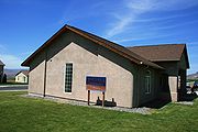
, the town boomed with construction workers. Mattawa was officially incorporated on June 3, 1958. The Port of Mattawa was also established in 1958. Mattawa is also home to the first straw bale
library in the United States. December 3, 2009, the City of Mattawa became a non-charter code city.
According to the United States Census Bureau
, the city has a total area of 0.5 square miles (1.3 km²), all of it land.
of 2000, there were 2,609 people, 495 households, and 438 families residing in the town. The population density
was 5,281.7 people per square mile (2,055.8/km²). There were 576 housing units at an average density of 1,166.1 per square mile (453.9/km²). The racial makeup of the town was 29.59% White, 0.19% African American, 0.54% Native American, 0.92% Asian, 65.85% from other races
, and 2.91% from two or more races. Hispanic or Latino of any race were 89.80% of the population.
There were 495 households out of which 66.7% had children under the age of 18 living with them, 64.2% were married couples
living together, 10.7% had a female householder with no husband present, and 11.5% were non-families. 5.5% of all households were made up of individuals and 2.0% had someone living alone who was 65 years of age or older. The average household size was 5.27 and the average family size was 4.79.
In the city the population was spread out with 38.1% under the age of 18, 20.4% from 18 to 24, 32.4% from 25 to 44, 7.6% from 45 to 64, and 1.5% who were 65 years of age or older. The median age was 22 years. For every 100 females there were 151.8 males. For every 100 females age 18 and over, there were 179.2 males.
The median income for a household in the town was $31,964, and the median income for a family was $25,921. Males had a median income of $13,669 versus $13,333 for females. The per capita income
for the city was $7,510. About 30.6% of families and 34.4% of the population were below the poverty line, including 38.0% of those under age 18 and 42.6% of those age 65 or over.
The Mattawa Police Department (MAPD) currently consists of a police chief and three full-time, fully commissioned general authority Washington State police officers.
Mattawa is served by the Wahluke School District
.
United States
The United States of America is a federal constitutional republic comprising fifty states and a federal district...
. The population was 2,609 at the 2000 census. An estimated population exists between 4500-6500 residents during peak fruit picking/agricultural season(s) and subsides by approximately 2000 residents during non-picking seasons.
History
Priest Rapids Dam
Priest Rapids Dam is a hydroelectric, concrete gravity dam; located on the Columbia River, between the Yakima Firing Range and the Hanford Nuclear Reservation, and bridges Yakima County and Grant County, in the U.S. state of Washington. The dam is 24 miles south of the town of Vantage, and 47 miles...
and Wanapum Dam
Wanapum Dam
Wanapum Dam is a hydroelectric project located on the Columbia River downstream from Vantage, Washington where Interstate 90 crosses the Columbia from Grant County into Kittitas County. It is owned by the Grant County Public Utility District. Its reservoir is named Lake Wanapum.The dam, and its...
, the town boomed with construction workers. Mattawa was officially incorporated on June 3, 1958. The Port of Mattawa was also established in 1958. Mattawa is also home to the first straw bale
Straw-bale construction
Straw-bale construction is a building method that uses bales of straw as structural elements, building insulation, or both...
library in the United States. December 3, 2009, the City of Mattawa became a non-charter code city.
Geography
Mattawa is located at 46°44′10"N 119°54′7"W (46.736069, -119.901965).According to the United States Census Bureau
United States Census Bureau
The United States Census Bureau is the government agency that is responsible for the United States Census. It also gathers other national demographic and economic data...
, the city has a total area of 0.5 square miles (1.3 km²), all of it land.
Demographics
As of the censusCensus
A census is the procedure of systematically acquiring and recording information about the members of a given population. It is a regularly occurring and official count of a particular population. The term is used mostly in connection with national population and housing censuses; other common...
of 2000, there were 2,609 people, 495 households, and 438 families residing in the town. The population density
Population density
Population density is a measurement of population per unit area or unit volume. It is frequently applied to living organisms, and particularly to humans...
was 5,281.7 people per square mile (2,055.8/km²). There were 576 housing units at an average density of 1,166.1 per square mile (453.9/km²). The racial makeup of the town was 29.59% White, 0.19% African American, 0.54% Native American, 0.92% Asian, 65.85% from other races
Race (United States Census)
Race and ethnicity in the United States Census, as defined by the Federal Office of Management and Budget and the United States Census Bureau, are self-identification data items in which residents choose the race or races with which they most closely identify, and indicate whether or not they are...
, and 2.91% from two or more races. Hispanic or Latino of any race were 89.80% of the population.
There were 495 households out of which 66.7% had children under the age of 18 living with them, 64.2% were married couples
Marriage
Marriage is a social union or legal contract between people that creates kinship. It is an institution in which interpersonal relationships, usually intimate and sexual, are acknowledged in a variety of ways, depending on the culture or subculture in which it is found...
living together, 10.7% had a female householder with no husband present, and 11.5% were non-families. 5.5% of all households were made up of individuals and 2.0% had someone living alone who was 65 years of age or older. The average household size was 5.27 and the average family size was 4.79.
In the city the population was spread out with 38.1% under the age of 18, 20.4% from 18 to 24, 32.4% from 25 to 44, 7.6% from 45 to 64, and 1.5% who were 65 years of age or older. The median age was 22 years. For every 100 females there were 151.8 males. For every 100 females age 18 and over, there were 179.2 males.
The median income for a household in the town was $31,964, and the median income for a family was $25,921. Males had a median income of $13,669 versus $13,333 for females. The per capita income
Per capita income
Per capita income or income per person is a measure of mean income within an economic aggregate, such as a country or city. It is calculated by taking a measure of all sources of income in the aggregate and dividing it by the total population...
for the city was $7,510. About 30.6% of families and 34.4% of the population were below the poverty line, including 38.0% of those under age 18 and 42.6% of those age 65 or over.
The Mattawa Police Department (MAPD) currently consists of a police chief and three full-time, fully commissioned general authority Washington State police officers.
Mattawa is served by the Wahluke School District
Wahluke School District
Wahluke School District is a public school district in rural Grant County, Washington, USA, serving the communities of Mattawa, Beverly, Schwana, and Desert Aire.As of October 2008, the district has an enrollment of 1,992 students and 112 classroom teachers....
.
External links
- - Local newspaper
- The Royal Register- Local newspaper]
- Mattawa Area News — Local newspaper
- Current articles, Mattawa Area News
- City website