

Baillie-Grohman Canal
Encyclopedia
The Baillie-Grohman Canal was a shipping canal between the headwaters of the Columbia River
and the upper Kootenay River
in the East Kootenay region of British Columbia
at a place now known as Canal Flats, BC
. The construction of the canal was required by the provincial government of British Columbia
as a condition of the canal's promoter receiving a substantial land concessions from the provincial government of British Columbia
in the area of Creston, BC
. The promoter, William Adolf Baillie-Grohman
(1851–1921), was a wealthy adventurer, hunter author, and business promoter. He declared the canal to be complete in 1889. The canal was an expensive failure, being used only three times during its entire existence. In 1902, on the last use by a vessel, the sternwheeler North Star
, the sternwheeler's captain, Frank P. Armstrong deliberately blew out the canal's lower lock gates with dynamite to allow the transit of his vessel.
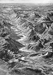 The Baillie-Grohman Canal was suggested by the unusual geographic setting of the sources of the Columbia and the Kootenay Rivers. The Columbia River begins at Columbia Lake
, flows north in the Rocky Mountain Trench
through the Columbia Valley
to Windermere Lake
to Golden, BC
. The Kootenay River flows south from the Rocky Mountains, then west into the Rocky Mountain Trench, coming within just over a mile from Columbia Lake, at a point called Canal Flats
, where a shipping canal was built in 1889. The Kootenay then flows south down the Rocky Mountain Trench, crosses the international border and then turns north back into Canada and into Kootenay Lake near the town of Creston, BC
.
Rail construction in Canada and the United States made steam navigation possible in the Rocky Mountain Trench. There were two important railhead
s, Golden, BC and Jennings, Montana, near Libby. At Golden, the transcontinental line of the Canadian Pacific Railway ("CPR"), which parallels the Columbia south from the bridge at Donald
, turns east to follow the Kicking Horse River
, surmounting the Continental Divide
at Kicking Horse Pass
, then running past the resort at Banff
then east to Calgary. Jennings was reached by the Great Northern Railway, built across the Northern United States from Minnesota
to Washington by James J. Hill
. Between these railheads the Rocky Mountain Trench ran for 300 miles, almost all of which was potentially accessible to steam navigation. Canal Flats was close to the midpoint, being just south of Columbia Lake, 124 miles upstream from Golden.
(1851–1921), travelled to the Kootenay Region and became obsessed with developing an area far down the Kootenay River near the southern end of Kootenay Lake
called Kootenay Flats. The problem for Baillie-Grohman was that the Kootenay River kept flooding Kootenay Flats. Baillie-Grohman thought the downstream flooding could be lessened by diverting the upstream portion of the Kootenay River into the Columbia River through the Canal Flats. This would have increased the water flow through the Columbia River, particularly near Golden and Donald, where Baillie-Grohman's proposal, if it had been implemented, would have threatened to flood the newly built transcontinental railroad and other areas of the Columbia Valley.
The provincial government refused to allow the diversion. However, Baillie-Grohman was able to obtain ownership of large areas of land in the Kootenay region, provided he engaged in certain forms of economic development, including construction of a shipping canal
and a lock. The lock was necessary because the Kootenay River was 11 feet higher than the level of the Columbia Lake.
River transport was the only way Baillie-Grohman could move the heavy sawmill and construction equipment the 124 miles to Canal Flats. The provincial government required Baillie-Grohman to complete the canal by the summer of 1889, then two years in the future. If he did not finish the canal on time, he would not receive the land far downstream. With Duchess under water and no other transport in sight, the clock was running on Baillie-Grohman's dream. There was at this time in Golden a man named Jack Hayes who had collected the pieces of a potential steamboat. These included an unpowered heavy-duty railroad construction barge, a vertical boiler
from a Manitoba
steam plow
, and machinery salvaged from an old tugboat
. Hayes however lacked the skill to assemble these components into a steamboat. Baillie-Grohman's only option was to task his millwright to help Jack Hayes complete the Clive.
Clive was much too heavy for the shallows of the Columbia River, which were often choked with snags, that is, dead trees which had become lodged in the bed of the river. Snags could block navigation or sink a vessel that might strike them. Under these conditions, it took Clive 23 days to cover the 100 miles from Golden to the point upriver where the sawmill could be unloaded.
When these were completed, and after a ceremony enhanced by what Sandiland described as "a canoe well laden with the 'good cheer' demanded by such an occasion", Sandiland was ordered by the foreman to break out the false dam which had been keeping the Kootenay River from flooding the works. With the aid of another worker he did so, and thus became, as he later realized, the man who made the entire Selkirk
and Purcell
mountain range into an island. With the canal in place, this entire huge alpine region was completely encircled by the Columbia River, the Arrow Lakes, the Kootenay Lake and River, and finally the canal itself.
45 ft (14 m) long and 45 ft (14 m) wide. Baillie-Grohman had raised funds for the venture in England, and was reputed to have sunk a major part of his own considerable personal wealth into the financing syndicate. The locks alone cost $100,000, enough to build five or six steamboats the size of the 1897 upper Kootenay sternwheeler J.D. Farrell
.
In 1893, Armstrong built Gwendoline
at Hansen's Landing on the Kootenay River, and took the vessel through the canal north to the shipyard at Golden to complete her fitting out. By this time it appears that the canal had been damaged or deteriorated to the boat where at least some of the transit of Gwendoline had to be accomplished by pulling the vessel of the water, partially dismantling the boat, and pulling her along on rollers. Over the winter, Armstrong, it is reported, was able to prevail on the provincial government to expend funds to repair the canal. In late May 1894 Armstrong returned the completed Gwendoline back to the Kootenay River, this time transiting normally the rehabilitated canal.
From 1892 to 1898, steamboats transported ore from the mines in the southern part of the Rocky Mountain Trench down the Kootenay River to Jennings Montana. In the fall of 1898, railroads were completed in this area which put the three surviving steamboats out of business, and for the most part they were little used after that. Armstrong, the dominant personality in river transport in the East Kootenay region, had been away steamboating on the Stikine River
as part of the Klondike Gold Rush
. With no work for North Star on the upper Kootenay with he returned, Armstrong decided in 1902 to bring the vessel through the Baillie-Grohman canal to be worked on the Columbia river side of the trench. It took a month to move North Star through the sloughed-in canal. Among other problems, North Star was 130 feet long, 30 feet longer than the lock. Armstrong solved this problem by ripping out the lock gates, building cofferdams out of ore sacks filed with sand, then blowing out the lower coffer dam with dynamite
.
visited Canal Flats, he could see traces of the canal running in from Columbia Lake which came to a sharp stop at a collapsing wall of rotting logs, which Freeman believed must have been the remnants of one of the lock gates. M.J. Lorraine, a retired civil engineer, found, photographed and diagrammed a similar situation in 1922.
Columbia River
The Columbia River is the largest river in the Pacific Northwest region of North America. The river rises in the Rocky Mountains of British Columbia, Canada, flows northwest and then south into the U.S. state of Washington, then turns west to form most of the border between Washington and the state...
and the upper Kootenay River
Kootenay River
The Kootenay is a major river in southeastern British Columbia, Canada and the northern part of the U.S. states of Montana and Idaho. It is one of the uppermost major tributaries of the Columbia River, which is the largest North American river that empties into the Pacific Ocean...
in the East Kootenay region of British Columbia
British Columbia
British Columbia is the westernmost of Canada's provinces and is known for its natural beauty, as reflected in its Latin motto, Splendor sine occasu . Its name was chosen by Queen Victoria in 1858...
at a place now known as Canal Flats, BC
Canal Flats, British Columbia
Canal Flats is a village located at the southern end of Columbia Lake, the source of the Columbia River in British Columbia, Canada. In 2006, it had a population of 700.-Location:...
. The construction of the canal was required by the provincial government of British Columbia
British Columbia
British Columbia is the westernmost of Canada's provinces and is known for its natural beauty, as reflected in its Latin motto, Splendor sine occasu . Its name was chosen by Queen Victoria in 1858...
as a condition of the canal's promoter receiving a substantial land concessions from the provincial government of British Columbia
British Columbia
British Columbia is the westernmost of Canada's provinces and is known for its natural beauty, as reflected in its Latin motto, Splendor sine occasu . Its name was chosen by Queen Victoria in 1858...
in the area of Creston, BC
Creston, British Columbia
Creston is a town of 4,826 people in the Kootenay region of southeastern British Columbia, Canada. The town is located just a few kilometers north of the Porthill, Idaho border crossing into the United States and about a three-hour drive north from Spokane, Washington. It is about a one-hour drive...
. The promoter, William Adolf Baillie-Grohman
William Adolf Baillie Grohman
William Adolph Baillie Grohman, was an Anglo-Austrian author of works on the Tyrol and the history of hunting, big game sportsman and Kootenay pioneer.-Biography:...
(1851–1921), was a wealthy adventurer, hunter author, and business promoter. He declared the canal to be complete in 1889. The canal was an expensive failure, being used only three times during its entire existence. In 1902, on the last use by a vessel, the sternwheeler North Star
North Star (sternwheeler 1897)
North Star was a sternwheel steamer that operated in western Montana and southeastern British Columbia on the Kootenay and Columbia rivers from 1897 to 1903. The vessel should not be confused with other steamers of the same name, some of which were similarly designed and operated in British...
, the sternwheeler's captain, Frank P. Armstrong deliberately blew out the canal's lower lock gates with dynamite to allow the transit of his vessel.
Geographic setting
Columbia Lake
Columbia Lake is the primary lake at the headwaters of the Columbia River, in British Columbia, Canada. It is fed by several small tributaries. The village of Canal Flats is located at the south end of the lake....
, flows north in the Rocky Mountain Trench
Rocky Mountain Trench
The Rocky Mountain Trench, or the Trench or The Valley of a Thousand Peaks, is a large valley in the northern part of the Rocky Mountains. It is both visually and cartographically a striking physiographic feature extending approximately from Flathead Lake, Montana, to the Liard River, just south...
through the Columbia Valley
Columbia Valley
The Columbia Valley is the name used for a region in the Rocky Mountain Trench near the headwaters of the Columbia River between the town of Golden and the Canal Flats. The main hub of the valley is the town of Invermere. Other towns include Radium Hot Springs, Windermere and Fairmont Hot Springs...
to Windermere Lake
Windermere Lake (British Columbia)
Lake Windermere is a very large widening in the Columbia River. The village of Windermere is located on the east side of the lake, and the larger town of Invermere is located on the lake's northwestern corner...
to Golden, BC
Golden, British Columbia
Golden is a town in southeastern British Columbia, Canada, located west of Calgary, Alberta and east of Vancouver.-History:Much of the town's history is tied into the Canadian Pacific Railway and the logging industry...
. The Kootenay River flows south from the Rocky Mountains, then west into the Rocky Mountain Trench, coming within just over a mile from Columbia Lake, at a point called Canal Flats
Canal Flats, British Columbia
Canal Flats is a village located at the southern end of Columbia Lake, the source of the Columbia River in British Columbia, Canada. In 2006, it had a population of 700.-Location:...
, where a shipping canal was built in 1889. The Kootenay then flows south down the Rocky Mountain Trench, crosses the international border and then turns north back into Canada and into Kootenay Lake near the town of Creston, BC
Creston, British Columbia
Creston is a town of 4,826 people in the Kootenay region of southeastern British Columbia, Canada. The town is located just a few kilometers north of the Porthill, Idaho border crossing into the United States and about a three-hour drive north from Spokane, Washington. It is about a one-hour drive...
.
Rail construction in Canada and the United States made steam navigation possible in the Rocky Mountain Trench. There were two important railhead
Railhead
The word railhead is a railway term with two distinct meanings, depending upon its context.Sometimes, particularly in the context of modern freight terminals, the word is used to denote a terminus of a railway line, especially if the line is not yet finished, or if the terminus interfaces with...
s, Golden, BC and Jennings, Montana, near Libby. At Golden, the transcontinental line of the Canadian Pacific Railway ("CPR"), which parallels the Columbia south from the bridge at Donald
Donald, British Columbia
Donald, British Columbia is located on Highway 1, 28 kilometers west of Golden. In its heyday, Donald was a divisional point on the Canadian Pacific Railway...
, turns east to follow the Kicking Horse River
Kicking Horse River
The Kicking Horse River is a river located in the Canadian Rockies of southeastern British Columbia, Canada.The river was named in 1858, when James Hector, a member of the Palliser Expedition, was kicked by his packhorse while exploring the river. Hector survived and named the river and the...
, surmounting the Continental Divide
Continental Divide
The Continental Divide of the Americas, or merely the Continental Gulf of Division or Great Divide, is the name given to the principal, and largely mountainous, hydrological divide of the Americas that separates the watersheds that drain into the Pacific Ocean from those river systems that drain...
at Kicking Horse Pass
Kicking Horse Pass
Kicking Horse Pass is a high mountain pass across the Continental Divide of the Americas of the Canadian Rockies on the Alberta/British Columbia border, and lying within Yoho and Banff National Parks...
, then running past the resort at Banff
Banff, Alberta
Banff is a town within Banff National Park in Alberta, Canada. It is located in Alberta's Rockies along the Trans-Canada Highway, approximately west of Calgary and east of Lake Louise....
then east to Calgary. Jennings was reached by the Great Northern Railway, built across the Northern United States from Minnesota
Minnesota
Minnesota is a U.S. state located in the Midwestern United States. The twelfth largest state of the U.S., it is the twenty-first most populous, with 5.3 million residents. Minnesota was carved out of the eastern half of the Minnesota Territory and admitted to the Union as the thirty-second state...
to Washington by James J. Hill
James J. Hill
James Jerome Hill , was a Canadian-American railroad executive. He was the chief executive officer of a family of lines headed by the Great Northern Railway, which served a substantial area of the Upper Midwest, the northern Great Plains, and Pacific Northwest...
. Between these railheads the Rocky Mountain Trench ran for 300 miles, almost all of which was potentially accessible to steam navigation. Canal Flats was close to the midpoint, being just south of Columbia Lake, 124 miles upstream from Golden.
William A. Baillie-Grohman
In the early 1880s a wealthy European adventurer, William Adolf Baillie-GrohmanWilliam Adolf Baillie Grohman
William Adolph Baillie Grohman, was an Anglo-Austrian author of works on the Tyrol and the history of hunting, big game sportsman and Kootenay pioneer.-Biography:...
(1851–1921), travelled to the Kootenay Region and became obsessed with developing an area far down the Kootenay River near the southern end of Kootenay Lake
Kootenay Lake
Kootenay Lake is a lake located in British Columbia, Canada and is part of theKootenay River. The lake has been raised by the Corra Linn Dam and has a dike system at the southern end, which, along with industry in the 1950s-70s, has changed the ecosystem in and around the water...
called Kootenay Flats. The problem for Baillie-Grohman was that the Kootenay River kept flooding Kootenay Flats. Baillie-Grohman thought the downstream flooding could be lessened by diverting the upstream portion of the Kootenay River into the Columbia River through the Canal Flats. This would have increased the water flow through the Columbia River, particularly near Golden and Donald, where Baillie-Grohman's proposal, if it had been implemented, would have threatened to flood the newly built transcontinental railroad and other areas of the Columbia Valley.
The provincial government refused to allow the diversion. However, Baillie-Grohman was able to obtain ownership of large areas of land in the Kootenay region, provided he engaged in certain forms of economic development, including construction of a shipping canal
Canal
Canals are man-made channels for water. There are two types of canal:#Waterways: navigable transportation canals used for carrying ships and boats shipping goods and conveying people, further subdivided into two kinds:...
and a lock. The lock was necessary because the Kootenay River was 11 feet higher than the level of the Columbia Lake.
Transport to the canal site
Baillie-Grohman arranged to have shipped to Golden a large amount of supplies, including complete equipment for a steam-powered sawmill, which was necessary to cut the lumber to built the canal locks and shelters for the workers at the canal. Baillie-Grohman also had hired a complement of workers, including a skilled millwright, to build the sawmill and supervise construction of the canal. Unfortunately when the time came to transport the supplies and the people by water to Canal Flats, Duchess, then the only steamer available, was then sunk in the deepest part of the river up to her smokestack.River transport was the only way Baillie-Grohman could move the heavy sawmill and construction equipment the 124 miles to Canal Flats. The provincial government required Baillie-Grohman to complete the canal by the summer of 1889, then two years in the future. If he did not finish the canal on time, he would not receive the land far downstream. With Duchess under water and no other transport in sight, the clock was running on Baillie-Grohman's dream. There was at this time in Golden a man named Jack Hayes who had collected the pieces of a potential steamboat. These included an unpowered heavy-duty railroad construction barge, a vertical boiler
Boiler
A boiler is a closed vessel in which water or other fluid is heated. The heated or vaporized fluid exits the boiler for use in various processes or heating applications.-Materials:...
from a Manitoba
Manitoba
Manitoba is a Canadian prairie province with an area of . The province has over 110,000 lakes and has a largely continental climate because of its flat topography. Agriculture, mostly concentrated in the fertile southern and western parts of the province, is vital to the province's economy; other...
steam plow
Traction engine
A traction engine is a self-propelled steam engine used to move heavy loads on roads, plough ground or to provide power at a chosen location. The name derives from the Latin tractus, meaning 'drawn', since the prime function of any traction engine is to draw a load behind it...
, and machinery salvaged from an old tugboat
Tugboat
A tugboat is a boat that maneuvers vessels by pushing or towing them. Tugs move vessels that either should not move themselves, such as ships in a crowded harbor or a narrow canal,or those that cannot move by themselves, such as barges, disabled ships, or oil platforms. Tugboats are powerful for...
. Hayes however lacked the skill to assemble these components into a steamboat. Baillie-Grohman's only option was to task his millwright to help Jack Hayes complete the Clive.
Clive was much too heavy for the shallows of the Columbia River, which were often choked with snags, that is, dead trees which had become lodged in the bed of the river. Snags could block navigation or sink a vessel that might strike them. Under these conditions, it took Clive 23 days to cover the 100 miles from Golden to the point upriver where the sawmill could be unloaded.
Construction of the canal and locks
As was common for construction projects in western North America at that time, the hard labor of building the canal was done by Chinese immigrant laborers. According to E.M. Sandilands, who worked on the canal, the project was fatally defective from the start, because nothing in the stipulations between Baillie-Grohman and the provincial government required Baillie-Grohman to dredge or prepare the approaches to the canal. All Baillie-Grohman had to do was build the canal and locks . However, without proper approaches, it would be near-to-useless.When these were completed, and after a ceremony enhanced by what Sandiland described as "a canoe well laden with the 'good cheer' demanded by such an occasion", Sandiland was ordered by the foreman to break out the false dam which had been keeping the Kootenay River from flooding the works. With the aid of another worker he did so, and thus became, as he later realized, the man who made the entire Selkirk
Selkirk Mountains
The Selkirk Mountains are a mountain range spanning the northern portion of the Idaho Panhandle, eastern Washington, and southeastern British Columbia. They begin at Mica Peak near Coeur d'Alene, Idaho and extend approximately 320 km north from the border. The range is bounded on its west,...
and Purcell
Purcell Mountains
The Purcell Mountains are a mountain range in southeastern British Columbia, Canada. They are a subrange of the Columbia Mountains, which includes the Selkirk, Monashee, and Cariboo Mountains. They are located on the west side of the Rocky Mountain Trench in the area of the Columbia Valley, and on...
mountain range into an island. With the canal in place, this entire huge alpine region was completely encircled by the Columbia River, the Arrow Lakes, the Kootenay Lake and River, and finally the canal itself.
Size and cost
When on July 29, 1889 complete, the canal was45 ft (14 m) long and 45 ft (14 m) wide. Baillie-Grohman had raised funds for the venture in England, and was reputed to have sunk a major part of his own considerable personal wealth into the financing syndicate. The locks alone cost $100,000, enough to build five or six steamboats the size of the 1897 upper Kootenay sternwheeler J.D. Farrell
J.D. Farrell (sternwheeler)
J.D. Farrell was a sternwheel steamer that operated on the Kootenay River in western Montana and southeastern British Columbia from 1898 to 1902.-Design and Construction:...
.
Limited use of canal
Despite its cost, the Baillie-Grohman canal was only transited three times by steam-powered vessels.- Transits of the Gwendoline in 1893 and 1894:
In 1893, Armstrong built Gwendoline
Gwendoline (sternwheeler)
Gwendoline was a sternwheel steamer that operated on the Kootenay River in British Columbia and northwestern Montana from 1893 to 1899. The vessel was also operated briefly on the Columbia River in the Columbia Valley.-Design and construction:...
at Hansen's Landing on the Kootenay River, and took the vessel through the canal north to the shipyard at Golden to complete her fitting out. By this time it appears that the canal had been damaged or deteriorated to the boat where at least some of the transit of Gwendoline had to be accomplished by pulling the vessel of the water, partially dismantling the boat, and pulling her along on rollers. Over the winter, Armstrong, it is reported, was able to prevail on the provincial government to expend funds to repair the canal. In late May 1894 Armstrong returned the completed Gwendoline back to the Kootenay River, this time transiting normally the rehabilitated canal.
- Transit of the North Star in 1902:
From 1892 to 1898, steamboats transported ore from the mines in the southern part of the Rocky Mountain Trench down the Kootenay River to Jennings Montana. In the fall of 1898, railroads were completed in this area which put the three surviving steamboats out of business, and for the most part they were little used after that. Armstrong, the dominant personality in river transport in the East Kootenay region, had been away steamboating on the Stikine River
Stikine River
The Stikine River is a river, historically also the Stickeen River, approximately 610 km long, in northwestern British Columbia in Canada and southeastern Alaska in the United States...
as part of the Klondike Gold Rush
Klondike Gold Rush
The Klondike Gold Rush, also called the Yukon Gold Rush, the Alaska Gold Rush and the Last Great Gold Rush, was an attempt by an estimated 100,000 people to travel to the Klondike region the Yukon in north-western Canada between 1897 and 1899 in the hope of successfully prospecting for gold...
. With no work for North Star on the upper Kootenay with he returned, Armstrong decided in 1902 to bring the vessel through the Baillie-Grohman canal to be worked on the Columbia river side of the trench. It took a month to move North Star through the sloughed-in canal. Among other problems, North Star was 130 feet long, 30 feet longer than the lock. Armstrong solved this problem by ripping out the lock gates, building cofferdams out of ore sacks filed with sand, then blowing out the lower coffer dam with dynamite
Dynamite
Dynamite is an explosive material based on nitroglycerin, initially using diatomaceous earth , or another absorbent substance such as powdered shells, clay, sawdust, or wood pulp. Dynamites using organic materials such as sawdust are less stable and such use has been generally discontinued...
.
Deterioration of the works
Whatever commercial value the canal may have had was completely wiped out by the dynamite-aided transit of the North Star. The remains of the canal and the locks lock gradually deteriorated In 1920, when the journalist-adventurer Lewis R. FreemanLewis R. Freeman
Lewis Ransome Freeman was an American explorer, journalist and war correspondent who wrote over twenty books chronicling his many travels, as well as numerous articles.-Biography:...
visited Canal Flats, he could see traces of the canal running in from Columbia Lake which came to a sharp stop at a collapsing wall of rotting logs, which Freeman believed must have been the remnants of one of the lock gates. M.J. Lorraine, a retired civil engineer, found, photographed and diagrammed a similar situation in 1922.
Failure of the Baillie-Grohman development scheme
Although Baillie-Grohman had completed the canal on time, or at least could claim he had done so, his plan for acquiring ownership of the Creston area failed when the provincial government was found to have exceeded its authority when it entered into the bargain with Baillie-Grohman.See also
- Steamboats of the upper Columbia and Kootenay RiversSteamboats of the upper Columbia and Kootenay RiversFrom 1886 to 1920, steamboats ran on the upper reaches of the Columbia and Kootenay in the Rocky Mountain Trench, in western North America. The circumstances of the rivers in the area, and the construction of transcontinental railways across the trench from east to west made steamboat navigation...
- Frank P. Armstrong (steamboat captain)Frank P. ArmstrongFrancis Patrick Armstrong was a steamboat captain in the East Kootenay region of British Columbia. He also operated steamboats on the Kootenay River in Montana and on the Stikine River in western British Columbia. Steam navigation in the Rocky Mountain Trench which runs through the East Kootenay...
Further reading
- Kluckner, Michael, Vanishing British Columbia, University of British Columbia Press, Vancouver BC, 2005 ISBN 0-295-98493-7
External links
- Fort Steele Heritage Town, map and diagram page Contains period maps of East Kootenay region, including original maps and later working diagrams of the Baillie-Grohman canal. In particular, this site includes simplified plans drawn by David Morley of the geographic location and the operation of the canal locks which are valuable illustrations of the theory behind the canal.
- Taming the Kootenay, Creston and District Historical and Museum Society Multi-media presentation of history of Canal Flats and the East Kootenay region