
List of numbered routes in Massachusetts
Encyclopedia

U.S. state
A U.S. state is any one of the 50 federated states of the United States of America that share sovereignty with the federal government. Because of this shared sovereignty, an American is a citizen both of the federal entity and of his or her state of domicile. Four states use the official title of...
of Massachusetts
Massachusetts
The Commonwealth of Massachusetts is a state in the New England region of the northeastern United States of America. It is bordered by Rhode Island and Connecticut to the south, New York to the west, and Vermont and New Hampshire to the north; at its east lies the Atlantic Ocean. As of the 2010...
, the highway division of the Massachusetts Department of Transportation (MassDOT) assigns and marks a system of state-numbered routes. U.S. Highways and Interstate Highways are included in the system; the only overlaps are with the end-to-end U.S. Route 3
U.S. Route 3
U.S. Route 3 is a north–south United States highway that runs from its southern terminus in Cambridge, Massachusetts through New Hampshire to its terminus near Third Connecticut Lake at the Canadian border, where the road continues north as Quebec Route 257.In New Hampshire parts of US 3 are...
and Route 3
Route 3 (Massachusetts)
Route 3 is a southward continuation of U.S. Route 3, connecting Cambridge, Massachusetts with Cape Cod. All of it, except for the northernmost end in downtown Boston and Cambridge, is a freeway....
and the far-apart Interstate 295 and Route 295. A state highway
State highway
State highway, state road or state route can refer to one of three related concepts, two of them related to a state or provincial government in a country that is divided into states or provinces :#A...
in Massachusetts is a road maintained by the state, which may or may not have a number. Not all numbered routes are maintained or owned by the state.
Facts
- The longest numbered highway in the state is U.S. Route 20, which runs for 153 miles (246.2 km).
- The longest state highway is Route 28Route 28 (Massachusetts)Route 28 is a nominally south–north route in the U.S. state of Massachusetts, running from the town of Orleans via Boston to the New Hampshire state line in Methuen. Following the route from its nominally southern end, Route 28 initially heads south to the town of Chatham then turns west to...
, which runs for 151.92 miles (244.5 km). - The longest Interstate highway in Massachusetts is Interstate 90Massachusetts TurnpikeThe Massachusetts Turnpike is the easternmost stretch of Interstate 90. The Turnpike begins at the western border of Massachusetts in West Stockbridge connecting with the Berkshire Connector portion of the New York State Thruway...
(the Mass Pike), which runs 138.1 miles (222.2 km). - The shortest route in Massachusetts is Route 15Route 15 (Massachusetts)Route 15 is a short, unsigned route in the U.S. state of Massachusetts, connecting Rhode Island's Route 15 with Route 152 in Seekonk. At a length of just under a quarter mile , it is the shortest numbered highway in the state.-Route description:...
, which runs for only 0.23 mile (0.3701482 km). The shortest signed highway is Route 108, which runs for 0.92 miles (1.5 km). Both are short extensions of state highways in neighboring states. The shortest route completely within state borders is Route 240, which runs for 1 miles (1.6 km). - The shortest Interstate in Massachusetts is Interstate 295, which runs as a 4 miles (6.4 km) extension of I-295 in Rhode IslandRhode IslandThe state of Rhode Island and Providence Plantations, more commonly referred to as Rhode Island , is a state in the New England region of the United States. It is the smallest U.S. state by area...
.
State routes


Route 24 (Massachusetts)
Route 24 is a freeway south of I-93 in southeastern Massachusetts, linking Fall River with the Boston metropolitan area. It begins in the south in Fall River at the border with Tiverton, Rhode Island where it connects with Rhode Island Route 24, and runs north to an interchange with Interstate...
and Route 128
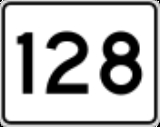
Route 128 (Massachusetts)
Route 128, also known as the Yankee Division Highway , and originally the Circumferential Highway, is a partial beltway around Boston, Massachusetts, United States. The majority of the highway is built to freeway standards, and about 3/5 of it is part of the Interstate Highway System...
have the same design, but are usually much larger in size for easier viewing at highway speeds.
Some older, erroneous signs have the sign in a white circle, and black on the outside, although occurrences of this are rare.
U.S. Routes

U.S. Route 3
U.S. Route 3 is a north–south United States highway that runs from its southern terminus in Cambridge, Massachusetts through New Hampshire to its terminus near Third Connecticut Lake at the Canadian border, where the road continues north as Quebec Route 257.In New Hampshire parts of US 3 are...
expressway are of a cut-out design, without the black background. U.S. Routes on freeways usually have extra-large sign panels posted.
NOTE: Alternates of U.S. routes in Massachusetts are signed as state highways (Routes 1A, 3A (northern), 6A, 7A, and 20A).
Interstate Highways

Massachusetts Turnpike
The Massachusetts Turnpike is the easternmost stretch of Interstate 90. The Turnpike begins at the western border of Massachusetts in West Stockbridge connecting with the Berkshire Connector portion of the New York State Thruway...
(Interstate 90), which uses standard shields.
Auxiliary routes
Route 38 (Massachusetts)
Route 38 is a state highway in Massachusetts, United States, running 27 miles from Sullivan Square in Boston north via Lowell to the state line in Dracut, where it continues as New Hampshire Route 38 in Pelham, New Hampshire...
).
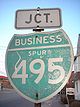
The Lowell Connector
Lowell Connector
The Lowell Connector, officially the American Legion Connector Highway, is a small freeway connector in the Massachusetts state highway system that links nearby U.S. Highway 3 and Interstate 495 to downtown Lowell, Massachusetts...
is technically the only "auxiliary" route in the state, having been formerly signed as Interstate 495 Business Spur in the 1960s. Most of the signage has been removed. The lone exception is on Plain Street in Lowell just west of the Connector.
Exit numbering
Massachusetts is one of the few U.S. states that still uses sequential exit numbering on its freeways. There are currently no plans to convert to mileage-based numbers. Massachusetts posts exit numbers on all of its Interstate Highways, as well as other major freeways in the state, including the freeway portions of Route 2, the Pilgrims Highway (part of Route 3), the Northwest Expressway (part of U.S. Route 3U.S. Route 3
U.S. Route 3 is a north–south United States highway that runs from its southern terminus in Cambridge, Massachusetts through New Hampshire to its terminus near Third Connecticut Lake at the Canadian border, where the road continues north as Quebec Route 257.In New Hampshire parts of US 3 are...
), Route 24, Route 25, Route 128, the southern portion of Route 140, Route 213, and most recently, Route 146.
Five freeways in Massachusetts contain irregular exit numbering patterns:
- On Route 2, exit numbers start at 14 and increase to 43, with a gap in the freeway between Concord and Lexington. Exit numbering resumes at 52 and ends at 60.
- The Northwest Expressway (US-3) is the one freeway in Massachusetts that still uses the "25 is 128" system. As such, its exit numbering scheme starts at 25 (at Route 128/I-95) and goes up to 36.
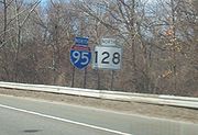
- Route 128 has reversed exit numbering; that is, exit numbers increase going north-to-south. Exit numbers start at 29 and end at 10. There are no exits 1-9, there is no Exit 11, and Exit 27 was removed. Route 128 has always had this system; however most of its exit numbering was replaced by the standard south-to-north of I-93 and I-95 south of Peabody.
- I-93 in Boston has gone under many exit numbering changes since the Big Dig project was completed, with many old interchanges being closed or reconfigured. Numbering on the Interstate goes from 1-48, but the following exit numbers no longer exist: 17, 19, 21, 22, and 25.
- Numbering on the Massachusetts Turnpike (I-90)Massachusetts TurnpikeThe Massachusetts Turnpike is the easternmost stretch of Interstate 90. The Turnpike begins at the western border of Massachusetts in West Stockbridge connecting with the Berkshire Connector portion of the New York State Thruway...
increases from 1-26; however, Exits 14 and 15 are the same exit, Exits 18 and 20 are the same exit, Exit 19 is a mainline toll plaza,and Exits 21 and 23 are onramps only.
Signage errors
Massachusetts is rather notorious for the placement of incorrect signage along its numbered highways. Some of these errors are due to outdated signage which have not been replaced since a realignment or truncation of a route, which can lead to confusion as to where a particular route goes. Lack of route signage in urban areas is a common problem.One very common signage error, which occurs in many states, is the mis-signage of a U.S. highway as a state route (mostly on guide signs). This occurs in many places along U.S. Route 202
U.S. Route 202
U.S. Route 202 is a highway stretching from Delaware to Maine, also passing through the states of Pennsylvania, New Jersey, New York, Connecticut, Massachusetts, and New Hampshire....
, as well as on sections of U.S. Route 20
U.S. Route 20
U.S. Route 20 is an east–west United States highway. As the "0" in its route number implies, US 20 is a coast-to-coast route. Spanning , it is the longest road in the United States, and the route sparsely parallels Interstate 90...
and in a few spots along U.S. Route 1
U.S. Route 1 in Massachusetts
In the U.S. state of Massachusetts, U.S. Route 1 is a major north–south state highway through Boston. The portion of US 1 south of Boston is also known as the Boston-Providence Turnpike, and portions north of the city are known as the Northeast Expressway and the Newburyport Turnpike.-Route...
, U.S. Route 6
U.S. Route 6 in Massachusetts
Route 6 is the portion of the cross-country U.S. Route 6 in the state of Massachusetts. Route 6 runs in the state connecting Providence, Rhode Island to Fall River, New Bedford, and Cape Cod. In the Fall River and New Bedford areas, Route 6 is a secondary highway paralleling Interstate 195...
and U.S. Route 44
U.S. Route 44
U.S. Route 44 is an east–west United States highway that runs for 237 miles through four states in the Northeastern region of the United States. The western terminus is at U.S. Route 209 and New York State Route 55 in Kerhonkson, a hamlet in the Hudson Valley region of New York...
. These are less confusing sign errors, as U.S. routes are part of the Massachusetts state highway system, and thus do not share numbers with other state routes (the one exception being U.S./MA Route 3, which connect end-to-end and are treated as the same route by the state).
A more unusual signage error occurred at the intersection of Route 10
Massachusetts Route 10
Massachusetts Route 10 is a north–south state highway that runs from the state line at Southwick to the state line at Northfield.-Route description:Route 10 crosses the border from Granby, Connecticut into Southwick, Massachusetts, overlapped with US 202...
and Route 141
Massachusetts Route 141
Route 141 is a west–east state highway in the U.S. state of Massachusetts. Its western terminus is at Route 10 in Easthampton. Its eastern terminus is at U.S...
in Easthampton
Easthampton, Massachusetts
Easthampton is the second largest city in Hampshire County, Massachusetts, United States. The town is on the southeastern edge of an area called the Pioneer Valley near the five colleges in the college towns of Northampton and Amherst, MA...
in July 2005, in which Alabama
Alabama
Alabama is a state located in the southeastern region of the United States. It is bordered by Tennessee to the north, Georgia to the east, Florida and the Gulf of Mexico to the south, and Mississippi to the west. Alabama ranks 30th in total land area and ranks second in the size of its inland...
state route markers were installed for the two routes. This error came from a contractor who mistakenly signed the route based on the design in the federal manual that showed an Alabama route marker.
History
The Massachusetts Highway Commission (MHC) was the first highway commission in the U.S., formed in 1893 in response to a commission of inquiry finding that over 90% of the public roads in the state were in poor condition. The first state highwayState highway
State highway, state road or state route can refer to one of three related concepts, two of them related to a state or provincial government in a country that is divided into states or provinces :#A...
in Massachusetts was a 5305.17-foot (1617.02 m) section of Fitchburg Road (now Main Street, part of Route 119
Route 119 (Massachusetts)
Route 119, is a northwest-southeast state highway in Massachusetts. It acts as a continuation of New Hampshire Route 119, which is in turn a continuation of Vermont Route 113.-Route description:Route 119 begins in Ashburnham at the New Hampshire state line...
) in Ashby. The MHC laid it out as a state highway on August 15, 1894 from a point west of South Road to a point west of Route 31
Route 31 (Massachusetts)
-Route description:It begins at the Connecticut border in Dudley, where a short unnumbered local road changes to MA-31. Through Dudley and Charlton, it is known as Dresser Hill Road. Dresser Hill road winds over Dresser Hill, with several moderately steep grades and some tight corners.In Charlton,...
. The road was paved with 15–20 foot (4.5–6 m) macadam
Macadam
Macadam is a type of road construction pioneered by the Scotsman John Loudon McAdam in around 1820. The method simplified what had been considered state-of-the-art at that point...
, with work beginning August 21, 1894 and ending July 15, 1895. The 50–66 foot (15–20 m) right-of-way
Easement
An easement is a certain right to use the real property of another without possessing it.Easements are helpful for providing pathways across two or more pieces of property or allowing an individual to fish in a privately owned pond...
is still owned by MassDOT under the original layout.
Massachusetts first gained numbered routes in 1922, with the formation of the New England Interstate Highways. Three-digit numbers were reserved for shorter routes. Route 138
Route 138 (Massachusetts)
Route 138 is a north–south state highway in Massachusetts. From Milton, Route 138 runs south through the following towns/cities:* Canton * Stoughton...
and Route 140
Route 140 (Massachusetts)
Route 140 is a long state highway which passes through parts of southeastern and central Massachusetts. The highway follows a southeast-northwest trajectory, running from U.S...
were designated by 1925, and by 1926 the numbers from Route 101 to Route 142 (except Route 136) had been assigned.
The establishment of the U.S. Highway System in 1926 resulted in several of the New England Interstate routes having to be renumbered. The New England Interstate routes that conflicted with new U.S. Highway numbers were assigned newly-freed single-digit numbers. Beginning in 1929, local routes were assigned new two-digit numbers. With the exception of Route 143, which was renumbered from Route 109A ca. 1933, new routes were given two-digit numbers for a while. Larger three-digit numbers were eventually assigned.
All routes that end at a state border and continue as a numbered route on the other side have been renumbered on one side of the border to match. Except for Route 295, far from Interstate 295, numbers that were duplicated with Interstate Highways were renumbered, mostly in 1959 when the Interstate numbers were assigned.
Agencies
The state agencies that maintain state roads are:- Massachusetts Department of Transportation
- Massachusetts Department of Conservation and Recreation
- Massachusetts Port AuthorityMassachusetts Port AuthorityMassachusetts Port Authority, or Massport, is a port district in the Commonwealth of Massachusetts. It operates seaports and airports in eastern and central Massachusetts, mainly the Port of Boston. Its headquarters is located in the Logan Office Center, adjacent to Logan Airport in East Boston,...
(Tobin BridgeTobin BridgeThe Maurice J. Tobin Memorial Bridge is a cantilever truss bridge that spans more than two miles from Charlestown to Chelsea over the Mystic River in Massachusetts. The bridge is the largest in New England...
, scheduled to be transferred to MassDOT on January 1, 2010)
Unnumbered state roads
These are state roads which, for the most part, do not carry a numbered designation. They are generally short in length and serve important roles as main roads or connections between other main roads.| Name | Length (mi) | Location | Notes |
|---|---|---|---|
| John F. Kennedy Memorial Highway | 1.5 | New Bedford New Bedford, Massachusetts New Bedford is a city in Bristol County, Massachusetts, United States, located south of Boston, southeast of Providence, Rhode Island, and about east of Fall River. As of the 2010 census, the city had a total population of 95,072, making it the sixth-largest city in Massachusetts... |
The JFK Memorial Highway is a semi-limited-access highway running through the city of New Bedford, from Cove St. in the south to I-195 in the north at Exit 15. The section between U.S. Route 6 and I-195 carries the initial stretch of Route 18. |
| Leominster Connector | 0.6 | Leominster Leominster, Massachusetts Leominster is a city in Worcester County, Massachusetts, United States. It is the second-largest city in Worcester County, with a population of 40,759 at the 2010 census. Leominster is located north of Worcester and west of Boston. Both Route 2 and Route 12 pass through Leominster. Interstate 190,... |
Leominster Connector is a short road connecting the I-190/Route 2 interchange in Leominster with Mechanic Street. |
| Leverett Connector | 1.6 | Boston | The Leverett Connector is a bypass of the Central Artery Central Artery The John F. Fitzgerald Expressway, known locally as the Central Artery, is a section of freeway in downtown Boston, Massachusetts, designated as Interstate 93, U.S. Route 1 and Route 3. It was initially constructed in the 1950s as a partly elevated and partly tunneled divided highway... from Interstate 93 Interstate 93 Interstate 93 is an Interstate Highway in the New England section of the United States. Its southern terminus is in Canton, Massachusetts, in the Boston metropolitan area, at Interstate 95; its northern terminus is near St. Johnsbury, Vermont, at Interstate 91... north of Boston to Storrow Drive Storrow Drive Storrow Drive is a major cross town expressway in Boston, Massachusetts, running south and west from Leverett Circle along the Charles River. It is a parkway—it is restricted to cars; trucks and buses are not permitted on it... . |
| Lowell Connector Lowell Connector The Lowell Connector, officially the American Legion Connector Highway, is a small freeway connector in the Massachusetts state highway system that links nearby U.S. Highway 3 and Interstate 495 to downtown Lowell, Massachusetts... |
2.88 | Chelmsford Chelmsford, Massachusetts Chelmsford is a suburban town in Middlesex County, Massachusetts in the Greater Boston area. As of the 2010 United States Census, the town's population was 33,802. The Census Bureau's 2008 population estimate for the town was 34,409, ranking it 14th in population among the 54 municipalities in... , Lowell Lowell, Massachusetts Lowell is a city in Middlesex County, Massachusetts, USA. According to the 2010 census, the city's population was 106,519. It is the fourth largest city in the state. Lowell and Cambridge are the county seats of Middlesex County... |
The Lowell Connector is a freeway connection between the Northwest Expressway (US-3), I-495, and downtown Lowell. The Connector carries the unsigned designation of I-495 Business Spur Lowell Connector The Lowell Connector, officially the American Legion Connector Highway, is a small freeway connector in the Massachusetts state highway system that links nearby U.S. Highway 3 and Interstate 495 to downtown Lowell, Massachusetts... . |
| Plimoth Plantation Highway Plimoth Plantation Highway Plimoth Plantation Highway is a short unnumbered two-lane freeway with plastic stanchions posted on a rumbled asphalt median in Plymouth, Massachusetts.-Route description:... |
2.04 | Plymouth | The Plimoth Plantation Highway is a connector between Routes 3 and 3A in Plymouth, also servicing Plimoth Plantation Plimoth Plantation Plimoth Plantation is a living museum in Plymouth, Massachusetts that shows the original settlement of the Plymouth Colony established in the 17th century by English colonists, some of whom later became known as Pilgrims. They were among the first people who emigrated to America to avoid religious... . Prior to 1957, this highway carried the southern portion of Route 3. |
| Sandwich Road Sandwich Road (Bourne) Sandwich Road is a two-lane state highway in Bourne, Massachusetts, United States, running from Bourne center east to Sandwich. It begins at a four-way intersection with Shore Road, County Road and Trowbridge Road in Bourne center; Waterhouse Road and Perry Avenue also once ended there... (partly  Route 6A Route 6ARoute 6A (Massachusetts) Route 6A is the name for parts of former U.S. Route 6 on Cape Cod. Most of "6A", as the locals call it, is also known as the Old King's Highway... ) |
5.1 | Bourne Bourne, Massachusetts Bourne is a town in Barnstable County, Massachusetts, United States. The population was 18,721 at the 2000 census.For geographic and demographic information on specific parts of the town of Bourne, please see the articles on Bourne , Buzzards Bay, Monument Beach, Pocasset, Sagamore, and Sagamore... |
Sandwich Road runs from the center of Bourne east to the Sandwich Sandwich, Massachusetts Sandwich is a town in Barnstable County, Massachusetts, United States. The population was 20,675 at the 2010 census. The Town Hall is located right next to the Dexter Grist Mill, in the historic district of town.... town line. East of the Sagamore Bridge Sagamore Bridge The Sagamore Bridge in Sagamore, Massachusetts carries U.S. Route 6 across the Cape Cod Canal, connecting Cape Cod with the rest of Massachusetts, USA.... , Sandwich Road carries Route 6A. |
| Soldiers Field Road Soldiers Field Road Soldiers Field Road is a major crosstown parkway in Boston, Massachusetts, running west to east from U.S. Route 20 in the neighborhood of Brighton to the Boston University Bridge... |
4.3 | Boston | Soldiers Field Road is a parkway, running from North Beacon Street (U.S. Route 20) in Brighton east to the Boston University Bridge (Route 2), where it continues as Storrow Drive. |
| Storrow Drive Storrow Drive Storrow Drive is a major cross town expressway in Boston, Massachusetts, running south and west from Leverett Circle along the Charles River. It is a parkway—it is restricted to cars; trucks and buses are not permitted on it... (James Jackson Storrow Memorial Drive) |
1.98 | Boston | Storrow Drive is a parkway, running from Soldiers Field Road at the Boston University Bridge (Route 2) eastward to an intersection with Embankment Road (Route 28) in downtown Boston. Prior to 1989, U.S. Route 1 was routed along Storrow Drive. |
Named numbered routes
These are named highways in the state which also carry numbered designations. Some are simply names of streets which carry a numbered route(s). Roads named after people/organizations were generally done so ceremoniously, after the numeric designation(s) already existed. Others carry more general names, such as the Southeast Expressway and Central ArteryCentral Artery
The John F. Fitzgerald Expressway, known locally as the Central Artery, is a section of freeway in downtown Boston, Massachusetts, designated as Interstate 93, U.S. Route 1 and Route 3. It was initially constructed in the 1950s as a partly elevated and partly tunneled divided highway...
in Boston (which both refer to the same continuous span of I-93).
Several named highways cover the entire length of a given route in the state; for example, all of Interstate 90
Interstate 90
Interstate 90 is the longest Interstate Highway in the United States at . It is the northernmost coast-to-coast interstate, and parallels US 20 for the most part. Its western terminus is in Seattle, at Edgar Martinez Drive S. near Safeco Field and CenturyLink Field, and its eastern terminus is in...
in Massachusetts is the Massachusetts Turnpike
Massachusetts Turnpike
The Massachusetts Turnpike is the easternmost stretch of Interstate 90. The Turnpike begins at the western border of Massachusetts in West Stockbridge connecting with the Berkshire Connector portion of the New York State Thruway...
, and the entire length of Route 213
Route 213 (Massachusetts)
Route 213 is a short 3½ mile state highway in Massachusetts. It connects Interstate 93 with Interstate 495 in Methuen, Massachusetts, just south of the New Hampshire border. It is a four-lane, controlled access highway along its entire length. Route 213 is also known locally as The Loop, due to...
is the Loop Connector.(*) denotes that the named highway spans the entire length of the numbered route in the state.
| Name | Route number designation(s) | Length (mi) | Location | Notes |
|---|---|---|---|---|
| Alewife Brook Parkway Alewife Brook Parkway Alewife Brook Parkway is a short parkway in Cambridge and Somerville, Massachusetts. It is listed on the National Register of Historic Places. It begins at Fresh Pond in Cambridge , and heads north on the east bank of Alewife Brook, crossing into West Somerville and ending at the Mystic River on... |
 Route 16 Route 16Massachusetts Route 16 Route 16 is an east–west state highway in Massachusetts. It begins in the west at an intersection with Route 12 and Route 193 in Webster, just north of the Connecticut state border... |
2.05 | Cambridge | Runs from Concord Avenue to the Mystic Valley Parkway. |
| American Legion Highway |  Route 177* Route 177* |
Westport | Runs through Tiverton, Rhode Island; Fall River, Massachusetts; Westport, Massachusetts | |
| Amvets Memorial Highway (Fall River Expressway) |
 Route 24* Route 24* |
40.91 | Fall River Fall River, Massachusetts Fall River is a city in Bristol County, Massachusetts, in the United States. It is located about south of Boston, southeast of Providence, Rhode Island, and west of New Bedford and south of Taunton. The city's population was 88,857 during the 2010 census, making it the tenth largest city in... to Randolph Randolph, Massachusetts The Town of Randolph is a city in Norfolk County, Massachusetts, United States. As of the 2010 census, the town population was 32,112. Randolph adopted a new charter effective January 2010 providing for a council-manager form of government instead of the traditional town meeting... |
Route 24 is a connector between the Fall River/New Bedford area east of Rhode Island to the Boston metropolitan area, connecting the major freeways of the area: I-195 in Fall River and I-93/US-1 near I-95 in Randolph. - Route 79 runs along the highway between Exits 7 and 9, concurrent with Route 24. - I-195 has a brief concurrency with Route 24 in Fall River. |
| Boston Post Road Boston Post Road The Boston Post Road was a system of mail-delivery routes between New York City and Boston, Massachusetts that evolved into the first major highways in the United States.The three major alignments were the Lower Post Road The Boston Post Road was a system of mail-delivery routes between New York... |
 U.S. Route 20 U.S. Route 20U.S. Route 20 in Massachusetts The cross-country U.S. Route 20 runs its easternmost in the U.S. state of Massachusetts. The highway crosses the state border from New Lebanon, New York into Hancock, Massachusetts, and runs eastward into Boston, where it ends at Route 2 in Kenmore Square... |
Marlborough Marlborough, Massachusetts Marlborough is a city in Middlesex County, Massachusetts, United States. The population was 38,499 at the 2010 census. Marlborough became a prosperous industrial town in the 19th century and made the transition to high technology industry in the late 20th century after the construction of the... to Weston Weston, Massachusetts Weston is a suburb of Boston located in Middlesex County, Massachusetts, United States in the Boston metro area. The population of Weston, according to the 2010 U.S. Census, is 11,261.... |
Most of US-20 between Marlborough and Weston runs along the Boston Post Road. | |
| Henry E. Bodurtha Highway Massachusetts Route 57 Route 57 is an east–west Massachusetts state route that runs from Monterey to Agawam. The eastern 5.0 miles in Agawam is a freeway that runs from Route 187 to the route's eastern terminus at U.S. Route 5.- Route description :... |
 Route 57 Route 57Massachusetts Route 57 Route 57 is an east–west Massachusetts state route that runs from Monterey to Agawam. The eastern 5.0 miles in Agawam is a freeway that runs from Route 187 to the route's eastern terminus at U.S. Route 5.- Route description :... |
5.0 | Agawam Agawam, Massachusetts The Town of Agawam is a city in Hampden County, Massachusetts, United States. The population was 28,438 at the 2010 census. Agawam sits on the western side of the Connecticut River, directly across from the City of Springfield, Massachusetts... |
Freeway comprises the eastern 5 miles (8 km) of Route 57, connecting Route 187 to U.S. Route 5 and I-91. |
| Boston-Worcester Turnpike |  Route 9 Route 9 |
Worcester Worcester, Massachusetts Worcester is a city and the county seat of Worcester County, Massachusetts, United States. Named after Worcester, England, as of the 2010 Census the city's population is 181,045, making it the second largest city in New England after Boston.... to Boston |
Route 9 between Worcester and Boston is mostly a divided full-access highway with traffic light-controlled intersections which serves as one of the main alternatives to the Massachusetts Turnpike Massachusetts Turnpike The Massachusetts Turnpike is the easternmost stretch of Interstate 90. The Turnpike begins at the western border of Massachusetts in West Stockbridge connecting with the Berkshire Connector portion of the New York State Thruway... . Many shopping centers, car dealers, full-service restaurants and businesses line the roadway on this stretch, especially in Framingham, such as Barnes & Noble, Marshalls, T.G.I. Fridays, Kohl's, Toys "R" Us, Best Buy, Olive Garden and Walmart. This stretch of the roadway is also encompassed in the Golden Triangle Golden Triangle (Massachusetts) The Golden Triangle is one of the largest retail districts in New England and is located on the borders of Framingham and Natick, Massachusetts, in the heart of the MetroWest region of the state. The district is anchored by the two malls in the area, Shoppers World and the Natick Collection... district of Massachusetts. |
|
| Central Artery Central Artery The John F. Fitzgerald Expressway, known locally as the Central Artery, is a section of freeway in downtown Boston, Massachusetts, designated as Interstate 93, U.S. Route 1 and Route 3. It was initially constructed in the 1950s as a partly elevated and partly tunneled divided highway... (John F. Fitzgerald Expressway) |
 Interstate 93 Interstate 93 U.S. Route 1 U.S. Route 1U.S. Route 1 in Massachusetts In the U.S. state of Massachusetts, U.S. Route 1 is a major north–south state highway through Boston. The portion of US 1 south of Boston is also known as the Boston-Providence Turnpike, and portions north of the city are known as the Northeast Expressway and the Newburyport Turnpike.-Route...  Route 3 Route 3 |
3.18 | Boston | The Central Artery is the portion of I-93 in downtown Boston, which runs from Massachusetts Ave. (just south of Exit 20) north to U.S. Route 1's departure at Exit 27. Route 3 leaves the Artery at Exit 26. |
| Commonwealth Avenue Commonwealth Avenue, Boston Commonwealth Avenue is a major street in the cities of Boston and Newton, Massachusetts. It begins at the western edge of the Public Garden, and continues west through the neighborhoods of the Back Bay, Kenmore Square, Allston, Brighton and Chestnut Hill... |
 Route 30 U.S. Route 20 Route 30 U.S. Route 20U.S. Route 20 in Massachusetts The cross-country U.S. Route 20 runs its easternmost in the U.S. state of Massachusetts. The highway crosses the state border from New Lebanon, New York into Hancock, Massachusetts, and runs eastward into Boston, where it ends at Route 2 in Kenmore Square...  Route 2 Route 2 |
Newton Newton, Massachusetts Newton is a city in Middlesex County, Massachusetts, United States bordered to the east by Boston. According to the 2010 U.S. Census, the population of Newton was 85,146, making it the eleventh largest city in the state.-Villages:... , Boston |
Stretches from Weston/Newton line to the Boston Public Garden. | |
| East Boston Expressway Massachusetts Route 1A Route 1A is a south–north state highway in Massachusetts. It is an alternate route to U.S. 1 with three signed sections and two unsigned sections where the highway is concurrent with its parent... |
 Route 1A Route 1AMassachusetts Route 1A Route 1A is a south–north state highway in Massachusetts. It is an alternate route to U.S. 1 with three signed sections and two unsigned sections where the highway is concurrent with its parent... |
1.2 | Boston | The East Boston Expressway comprises the first 1.2 miles (1.9 km) of Route 1A's northern segment. It stretches from I-93 Exit 24 at the southern end of the Callahan Tunnel (northbound) and the Sumner Tunnel (southbound) to just northeast of the interchange with Route 145 in East Boston, near the eastern end of the Mass Pike. |
| Grand Army of the Republic Highway | U.S. Route 6 U.S. Route 6 in Massachusetts Route 6 is the portion of the cross-country U.S. Route 6 in the state of Massachusetts. Route 6 runs in the state connecting Providence, Rhode Island to Fall River, New Bedford, and Cape Cod. In the Fall River and New Bedford areas, Route 6 is a secondary highway paralleling Interstate 195... * |
117.46 | Seekonk Seekonk, Massachusetts Seekonk is a town in Bristol County, Massachusetts, United States, on the Massachusetts border. It was incorporated in 1812 from the western half of Rehoboth. The population was 13,722 at the 2010 census. Until 1862, the town of Seekonk also included what is now the City of East Providence, Rhode... to Provincetown Provincetown, Massachusetts Provincetown is a New England town located at the extreme tip of Cape Cod in Barnstable County, Massachusetts, United States. The population was 3,431 at the 2000 census, with an estimated 2007 population of 3,174... |
The cross-country U.S. Route 6 is designated Grand Army of the Republic Highway over its entire length, which spans 3205 miles (5,157.9 km). |
| Horseneck Beach Connector |  Route 88* Route 88* |
13.03 | Westport Westport, Massachusetts Westport is a town in Bristol County, Massachusetts, United States. The population was 15,532 at the 2010 census.The village of North Westport lies in the town.- History :... |
Route 88 serves as a connector running from the Horseneck Beach Reservation north to I-195 Exit 18 in Westport. |
| Loop Connector |  Route 213* Route 213* |
3.56 | Methuen Methuen, Massachusetts Methuen is a city in Essex County, Massachusetts, United States. The population was 43,789 at the 2000 census.-History:Methuen was first settled in 1642 and was officially incorporated in 1726; it is named for the British diplomat Sir Paul Methuen. Methuen was originally part of Haverhill,... |
Route 213 was designated "Loop Connector" when the Methuen Mall was renamed "The Loop." It serves as a freeway connection between Interstates 93 and 495 in Methuen. |
| Lydia Taft Highway |  Route 146A* Route 146A* |
3 | Uxbridge Uxbridge, Massachusetts Uxbridge is a town in Worcester County, Massachusetts, in the United States. It was first settled in 1662, incorporated in 1727 at Suffolk County, and named for the Earl of Uxbridge. Uxbridge is south-southeast of Worcester, north-northwest of Providence, and southwest of Boston. It is part of... |
Route 146A in Massachusetts is designated as the Lydia Taft Highway, which runs from the Rhode Island state border to Route 122 in Uxbridge. |
| Massachusetts Turnpike Massachusetts Turnpike The Massachusetts Turnpike is the easternmost stretch of Interstate 90. The Turnpike begins at the western border of Massachusetts in West Stockbridge connecting with the Berkshire Connector portion of the New York State Thruway... |
Interstate 90 Massachusetts Turnpike The Massachusetts Turnpike is the easternmost stretch of Interstate 90. The Turnpike begins at the western border of Massachusetts in West Stockbridge connecting with the Berkshire Connector portion of the New York State Thruway... * |
138.1 | West Stockbridge West Stockbridge, Massachusetts West Stockbridge is a town in Berkshire County, Massachusetts, United States. It is part of the Pittsfield, Massachusetts Metropolitan Statistical Area. The population was 1,416 at the 2000 census.- History :... to Boston |
The Mass Pike is a toll road running from the New York state border to downtown Boston. It serves as the main cross-state freeway connecting the western and eastern portions of the state. The "Pike" carries the easternmost 138 miles (222.1 km) of cross-country Interstate 90. |
| Memorial Drive Memorial Drive (Cambridge) Memorial Drive runs along the north bank of the Charles River in Cambridge, Massachusetts. It is designated as U.S. Route 3 or Massachusetts Route 3 for its entire length, and Massachusetts Route 2 over the portion west of the Boston University Bridge.... |
 U.S. Route 3 U.S. Route 3U.S. Route 3 U.S. Route 3 is a north–south United States highway that runs from its southern terminus in Cambridge, Massachusetts through New Hampshire to its terminus near Third Connecticut Lake at the Canadian border, where the road continues north as Quebec Route 257.In New Hampshire parts of US 3 are... Route 3 Route 2 |
4.12 | Cambridge Cambridge, Massachusetts Cambridge is a city in Middlesex County, Massachusetts, United States, in the Greater Boston area. It was named in honor of the University of Cambridge in England, an important center of the Puritan theology embraced by the town's founders. Cambridge is home to two of the world's most prominent... |
U.S. Route 3 and MA Route 3 connect to each other on Memorial Drive, which runs from the Fresh Pond Parkway to Main Street. Route 2 travels along Memorial Drive with US-3 and leaves via the Boston University Bridge. |
| Mid-Cape Highway | U.S. Route 6 U.S. Route 6 in Massachusetts Route 6 is the portion of the cross-country U.S. Route 6 in the state of Massachusetts. Route 6 runs in the state connecting Providence, Rhode Island to Fall River, New Bedford, and Cape Cod. In the Fall River and New Bedford areas, Route 6 is a secondary highway paralleling Interstate 195... |
36.6 | Bourne Bourne, Massachusetts Bourne is a town in Barnstable County, Massachusetts, United States. The population was 18,721 at the 2000 census.For geographic and demographic information on specific parts of the town of Bourne, please see the articles on Bourne , Buzzards Bay, Monument Beach, Pocasset, Sagamore, and Sagamore... to Orleans Orleans, Massachusetts Orleans is a town in Barnstable County, Massachusetts, United States. Barnstable County is coextensive with Cape Cod. The population was 5,890 at the 2010 census.... |
The Mid-Cape Highway is the main highway on Cape Cod, a 36 miles (57.9 km) long freeway running from Route 3 and the Sagamore Bridge east to the Orleans Rotary. |
| Mohawk Trail Mohawk Trail - External links :* *... |
Route 2 |
65 | Williamstown Williamstown, Massachusetts Williamstown is a town in Berkshire County, in the northwest corner of Massachusetts. It shares a border with Vermont to the north and New York to the west. It is part of the Pittsfield, Massachusetts Metropolitan Statistical Area. The population was 7,754 at the 2010 census... to Orange Orange, Massachusetts Orange is a town in Franklin County, Massachusetts, United States. The population was 7,839 at the 2010 census. It is part of the Springfield, Massachusetts Metropolitan Statistical Area.Part of the town is included in the census-designated place of Orange.... |
The 65 miles (104.6 km) Mohawk Trail comprises the western section of Route 2, from the New York border east to Orange, and is regarded as one of the most scenic drives in the area. |
| Mystic Valley Parkway Mystic Valley Parkway Mystic Valley Parkway is a short parkway in Arlington, Medford, Somerville, and Winchester, Massachusetts. It is listed on the National Register of Historic Places, and forms part of Route 16.... |
Route 16 Massachusetts Route 16 Route 16 is an east–west state highway in Massachusetts. It begins in the west at an intersection with Route 12 and Route 193 in Webster, just north of the Connecticut state border... |
Arlington Arlington, Massachusetts Arlington is a town in Middlesex County, Massachusetts, United States, six miles northwest of Boston. The population was 42,844 at the 2010 census.-History:... , Medford Medford, Massachusetts Medford is a city in Middlesex County, Massachusetts, in the United States, on the Mystic River, five miles northwest of downtown Boston. In the 2010 U.S. Census, Medford's population was 56,173... , Winchester Winchester, Massachusetts Winchester is a town located in Middlesex County, Massachusetts, eight miles north of Boston. With its agricultural roots having mostly disappeared, it is now an affluent suburb... |
Runs from the Alewife Brook Parkway to the Revere Beach Parkway. | |
| Northeast Expressway | U.S. Route 1 |
4.1 | Boston, Chelsea Chelsea, Massachusetts Chelsea is a city in Suffolk County, Massachusetts, United States directly across the Mystic River from the city of Boston. It is the smallest city in Massachusetts in land area, and the 26th most densely populated incorporated place in the country.-History:... , Revere Revere, Massachusetts Revere is a city in Suffolk County, Massachusetts, United States, and located approximately from downtown Boston. It is named after the American patriot Paul Revere. As of the 2010 census, the city population was 51,755.- History :... |
This section of U.S. Route 1 runs from I-93 Exit 27 (Tobin Bridge) to an interchange with Route 60 in Revere. This was originally supposed to be part of I-95, but I-95 was cancelled in Boston, with I-93 and US-1 taking its place. |
| Northwest Expressway | U.S. Route 3 U.S. Route 3 U.S. Route 3 is a north–south United States highway that runs from its southern terminus in Cambridge, Massachusetts through New Hampshire to its terminus near Third Connecticut Lake at the Canadian border, where the road continues north as Quebec Route 257.In New Hampshire parts of US 3 are... |
21.1 | Burlington Burlington, Massachusetts Burlington is a town in Middlesex County, Massachusetts, United States. The population was 24,498 at the 2010 census.- History :It is believed that Burlington takes its name from the English town of Bridlington, however this has never been confirmed.... to Tyngsborough Tyngsborough, Massachusetts Tyngsborough is a town located in the northwest section of Middlesex County, Massachusetts. Composed of of land and surface water, Tyngsborough borders the towns of Dunstable, Groton, Westford, Chelmsford, Dracut, and the City of Lowell, as well as the New Hampshire communities of Hudson,... |
The Northwest Expressway serves as a freeway connection between I-95/Route 128 (Exit 32A) in Burlington and the F.E. Everett Turnpike in Nashua, NH. |
| Pilgrims Highway | Route 3 |
42.5 | Bourne Bourne, Massachusetts Bourne is a town in Barnstable County, Massachusetts, United States. The population was 18,721 at the 2000 census.For geographic and demographic information on specific parts of the town of Bourne, please see the articles on Bourne , Buzzards Bay, Monument Beach, Pocasset, Sagamore, and Sagamore... to Braintree Braintree, Massachusetts The Town of Braintree is a suburban city in Norfolk County, Massachusetts, United States. Although officially known as a town, Braintree adopted a municipal charter, effective 2008, with a mayor-council form of government and is considered a city under Massachusetts law. The population was 35,744... |
The Pilgrims Highway is the southern portion of Route 3, a 42 miles (67.6 km) long freeway which serves as a connector between Cape Cod (via U.S. Route 6) and the Boston metropolitan area (via I-93 and I-95). - U.S. Route 44 runs along the highway between Exits 6 and 7. |
| Southeast Expressway | Interstate 93 U.S. Route 1 U.S. Route 1 in Massachusetts In the U.S. state of Massachusetts, U.S. Route 1 is a major north–south state highway through Boston. The portion of US 1 south of Boston is also known as the Boston-Providence Turnpike, and portions north of the city are known as the Northeast Expressway and the Newburyport Turnpike.-Route... Route 3 |
Braintree Braintree, Massachusetts The Town of Braintree is a suburban city in Norfolk County, Massachusetts, United States. Although officially known as a town, Braintree adopted a municipal charter, effective 2008, with a mayor-council form of government and is considered a city under Massachusetts law. The population was 35,744... to Boston |
The Southeast Expressway is the section of I-93 between the Route 3 split (Exit 7) and the Mass Ave. interchange (Exit 18), where it continues into Boston as the Central Artery. | |
| Southern Artery Southern Artery Southern Artery is a street in Quincy, Massachusetts. For much of its length it is a major arterial street which is used by an average of over 30,000 Boston area commuters daily.-History:... |
 Route 3A Route 3A Route 53 Route 53Massachusetts Route 53 -History:Route 53 follows the former routing of the Kingston to Quincy section of Route 3 which was moved onto the Southeast Expressway and Pilgrim's Highway expressway when they were fully completed in 1963... |
2.13 | Quincy Quincy, Massachusetts Quincy is a city in Norfolk County, Massachusetts, United States. Its nicknames are "City of Presidents", "City of Legends", and "Birthplace of the American Dream". As a major part of Metropolitan Boston, Quincy is a member of Boston's Inner Core Committee for the Metropolitan Area Planning Council... |
The Southern Artery is a major arterial in the city of Quincy, running from Quincy Ave to the Furnace Brook Parkway. |
| Taunton-New Bedford Expressway Route 140 (Massachusetts) Route 140 is a long state highway which passes through parts of southeastern and central Massachusetts. The highway follows a southeast-northwest trajectory, running from U.S... (Alfred M. Bessette Memorial Highway) |
 Route 140 Route 140Route 140 (Massachusetts) Route 140 is a long state highway which passes through parts of southeastern and central Massachusetts. The highway follows a southeast-northwest trajectory, running from U.S... |
19.3 | New Bedford New Bedford, Massachusetts New Bedford is a city in Bristol County, Massachusetts, United States, located south of Boston, southeast of Providence, Rhode Island, and about east of Fall River. As of the 2010 census, the city had a total population of 95,072, making it the sixth-largest city in Massachusetts... to Taunton Taunton, Massachusetts Taunton is a city in Bristol County, Massachusetts, United States. It is the seat of Bristol County and the hub of the Greater Taunton Area. The city is located south of Boston, east of Providence, north of Fall River and west of Plymouth. The City of Taunton is situated on the Taunton River... |
The New Bedford Expressway comprises the southern 19 miles (30.6 km) of Route 140, and serves as a freeway connection between U.S. Route 6 in New Bedford and Route 24 (Exit 12) in Taunton, near I-495. |
| Ted Williams Highway | Route 9 |
Framingham Framingham, Massachusetts Framingham is a New England town in Middlesex County, Massachusetts, United States. The population was 68,318 as of the United States 2010 Census. -History:... |
Route 9 in Framingham is named the Ted Williams Highway, in commemoration of late Boston Red Sox Boston Red Sox The Boston Red Sox are a professional baseball team based in Boston, Massachusetts, and a member of Major League Baseball’s American League Eastern Division. Founded in as one of the American League's eight charter franchises, the Red Sox's home ballpark has been Fenway Park since . The "Red Sox"... Hall-of-Famer Ted Williams Ted Williams Theodore Samuel "Ted" Williams was an American professional baseball player and manager. He played his entire 21-year Major League Baseball career as the left fielder for the Boston Red Sox... who wore the number 9 on his jersey. |
|
| Wilbur Cross Highway Wilbur Cross Highway The Wilbur Cross Highway is the designation for the portion of old Route 15 from Wethersfield in Connecticut, through Hartford and Manchester, to the Massachusetts Turnpike in Sturbridge, Massachusetts. The highway was built in the 1940s before the Interstate Highway era... |
 Interstate 84 Interstate 84Interstate 84 (east) Interstate 84 is an Interstate Highway extending from Dunmore, Pennsylvania at an interchange with Interstate 81 to Sturbridge, Massachusetts, at an interchange with the Massachusetts Turnpike . I-84 has mile-log junction numbering in Pennsylvania; otherwise, exit numbers are roughly sequential... * |
8.0 | Sturbridge Sturbridge, Massachusetts Sturbridge is a town in Worcester County, Massachusetts, United States. It is home to Old Sturbridge Village living history museum and other sites of historical interest such as Tantiusques.The population was 9,268 at the 2010 census... |
I-84 in Massachusetts is designated the Wilbur Cross Highway. It runs 8 miles (12.9 km) from the Connecticut state border to the Mass Pike at Exit 9. |
| Worcester-Providence Turnpike |  Route 146 Route 146Route 146 (Massachusetts) Route 146 is a high-speed road, mostly freeway, linking Rhode Island Route 146 to I-290 in Worcester, Massachusetts. South of the interchange with Route 122A, Route 146 is known as the Worcester-Providence Turnpike... * |
20.99 | Millville Millville, Massachusetts Millville is a town in Worcester County, Massachusetts, United States. The population was 3,190 at the 2010 census. It is part of the Providence metropolitan area.- History :... to Worcester Worcester, Massachusetts Worcester is a city and the county seat of Worcester County, Massachusetts, United States. Named after Worcester, England, as of the 2010 Census the city's population is 181,045, making it the second largest city in New England after Boston.... |
Route 146 is a freeway that, along with Rhode Island's Route 146, serves to connect the metropolitan areas of Providence and Worcester. The entire route starts from I-95 in Providence, with the Massachusetts section picking up at the state line in Millville. The highway runs 21 miles (33.8 km) northward, intersecting the Mass Pike (I-90) in Worcester, and terminating at I-290 shortly thereafter. - Route 122A runs along the highway between Exits 9 and 12, concurrently with Route 146. |
| Yankee Division Highway (Circumferential Highway) |
 Route 128* Route 128* Interstate 95 Interstate 95Interstate 95 in Massachusetts Interstate 95 is the main highway on the East Coast of the United States, paralleling the Atlantic Ocean from Florida to Maine. The Massachusetts portion of the highway enters from the state of Rhode Island in Attleboro and travels in a northeasterly direction to the junction with Route 128 in... U.S. Route 1 Interstate 93Interstate 93 Interstate 93 is an Interstate Highway in the New England section of the United States. Its southern terminus is in Canton, Massachusetts, in the Boston metropolitan area, at Interstate 95; its northern terminus is near St. Johnsbury, Vermont, at Interstate 91... |
64.74 | Braintree Braintree, Massachusetts The Town of Braintree is a suburban city in Norfolk County, Massachusetts, United States. Although officially known as a town, Braintree adopted a municipal charter, effective 2008, with a mayor-council form of government and is considered a city under Massachusetts law. The population was 35,744... to Gloucester Gloucester, Massachusetts Gloucester is a city on Cape Ann in Essex County, Massachusetts, in the United States. It is part of Massachusetts' North Shore. The population was 28,789 at the 2010 U.S. Census... |
The Yankee Division Highway consists of the Route 128 beltway before it was truncated to its southern terminus in Canton, and continues to span its entire length. It stretches from I-93's Exit 7 in Braintree to Route 128's northern terminus at Route 127A in Gloucester. - I-95 runs along the highway between Exits 12 and 45 (concurrent with 128). - I-93 runs along the highway between Exits 1 and 7. - U.S. Route 1 runs along the highway between I-95 Exit 15B and I-93 Exit 7. |
List of Routes
| 1-35 | 36-99 | 100-139 | 140-495 | Former Routes | New England Interstates |
|---|---|---|---|---|---|
| U.S. Route 1 Route 1A Route 1A (Massachusetts) Route 1A is a south–north state highway in Massachusetts. It is an alternate route to U.S. 1 with three signed sections and two unsigned sections where the highway is concurrent with its parent... Route 2Route 2 (Massachusetts) Route 2 is a major east–west state highway in Massachusetts, parts of which are sometimes known as the Cambridge and Concord Turnpike. Along with Route 9 and U.S. Route 20 to the south, these highways are the main alternatives to the Massachusetts Turnpike/I-90 toll highway...  Route 2A Route 2ARoute 2A (Massachusetts) Route 2A exists in several sections of Massachusetts, mainly as parts of former Route 2 that have been moved or upgraded. Route 2A runs from Greenfield in the west to Boston in the east... U.S. Route 3 Route 3Route 3 (Massachusetts) Route 3 is a southward continuation of U.S. Route 3, connecting Cambridge, Massachusetts with Cape Cod. All of it, except for the northernmost end in downtown Boston and Cambridge, is a freeway.... Route 3A  Route 4 Route 4Route 4 (Massachusetts) Route 4 is an long state highway in northeastern Massachusetts. It runs south to north, serving many of Boston's western and northwestern suburbs, from an interchange with Route 2 in Lexington northwest to an intersection with Route 3A in North Chelmsford. Much of it, north of Lexington, runs...  U.S. Route 5 U.S. Route 6 Route 6A U.S. Route 5 U.S. Route 6 Route 6ARoute 6A (Massachusetts) Route 6A is the name for parts of former U.S. Route 6 on Cape Cod. Most of "6A", as the locals call it, is also known as the Old King's Highway...  U.S. Route 7 U.S. Route 7  Route 7A Route 7ARoute 7A (Massachusetts) Route 7A is a state highway and alternate to U.S. Route 7 in western Massachusetts. It has two posted segments, with a total length of . Between these segments, Route 7A is coextensive with Route 7.-Route description:...  Route 8 Route 8  Route 8A Route 8ARoute 8A (Massachusetts) Route 8A refers to two separate north–south state highways in western Massachusetts. Both sections are marked as "Route 8A" on guide signs and reassurance markers... Route 9Route 9 (Massachusetts) Route 9 is a major east–west state highway in Massachusetts. Along with U.S. Route 20, Route 2 and the Massachusetts Turnpike, Route 9 is one of the major east-west routes of Massachusetts, and like the others its eastern terminus is in Boston...  Route 10 Route 10  Route 12 Route 12  Route 13 Route 13Route 13 (Massachusetts) Route 13 is a 14.1-mile north–south highway in north-central Massachusetts.-Route description:Route 13 begins at Route 12 north of downtown, where that route turns from Main Street to North Main Street...  Route 14 Route 14Route 14 (Massachusetts) Route 14 is an 18.5-mile highway in southeastern Massachusetts. It runs from Route 27 in Brockton east to Route 3A in Duxbury, near the coastline.Massachusetts Route 3 has an interchange with Route 14, at Exit 11 in Duxbury....  Route 15 Route 15Route 15 (Massachusetts) Route 15 is a short, unsigned route in the U.S. state of Massachusetts, connecting Rhode Island's Route 15 with Route 152 in Seekonk. At a length of just under a quarter mile , it is the shortest numbered highway in the state.-Route description:... Route 16  Route 18 Route 18Route 18 (Massachusetts) Route 18 is a south–north state highway in southeastern Massachusetts.-Route description:Route 18 starts as a four-lane freeway, a continuation of John F. Kennedy Memorial Highway in downtown New Bedford, at U.S. Route 6. After the intersection with I-195, Route 18 runs via surface streets...  Route 19 Route 19Route 19 (Massachusetts) Route 19 is a 16.5-mile north–south state highway located in south central Massachusetts. It runs from the Connecticut border in Wales north to an intersection with Massachusetts Route 9 and Massachusetts Route 67 in the town of West Brookfield.... U.S. Route 20  Route 20A Route 20A  Route 21 Route 21  Route 22 Route 22Route 22 (Massachusetts) Route 22 is a short north–south Massachusetts state route that connects Beverly and Essex. The entire route is located within Essex County.-Route description:...  Route 23 Route 23Route 23 (Massachusetts) Route 23 is a west–east route in the western Massachusetts counties of Berkshire and Hampden. The entire route is . The vast majority of the road follows the Knox Trail, the historic route of General Henry Knox took to bring cannon from Fort Ticonderoga on Lake Champlain in New York to aid... Route 24Route 24 (Massachusetts) Route 24 is a freeway south of I-93 in southeastern Massachusetts, linking Fall River with the Boston metropolitan area. It begins in the south in Fall River at the border with Tiverton, Rhode Island where it connects with Rhode Island Route 24, and runs north to an interchange with Interstate...  Route 25 Route 25Route 25 (Massachusetts) Route 25 is a numbered state highway located in Plymouth County and Barnstable County, Massachusetts, United States. The route is a nominally east–west freeway for its entire length, and less commonly known as the Blue Star Memorial Highway. An eastward continuation of Interstate 495, Route 25... Route 27Route 27 (Massachusetts) -Route description:Route 27 runs in a sweeping arc from Kingston to Chelmsford. For most of its route, it acts as an intermediate route between Interstate 95 and Interstate 495....  Route 28 Route 28Route 28 (Massachusetts) Route 28 is a nominally south–north route in the U.S. state of Massachusetts, running from the town of Orleans via Boston to the New Hampshire state line in Methuen. Following the route from its nominally southern end, Route 28 initially heads south to the town of Chatham then turns west to...  Route 28A Route 30 Route 28A Route 30Route 30 (Massachusetts) Route 30 is an east–west arterial, connecting Grafton with Packard's Corner in Boston. Route 30 runs roughly parallel to the Massachusetts Turnpike and Route 9, but unlike those two larger highways, takes a more meandering path from town to town...  Route 31 Route 31Route 31 (Massachusetts) -Route description:It begins at the Connecticut border in Dudley, where a short unnumbered local road changes to MA-31. Through Dudley and Charlton, it is known as Dresser Hill Road. Dresser Hill road winds over Dresser Hill, with several moderately steep grades and some tight corners.In Charlton,...  Route 32 Route 32  Route 32A Route 32A  Route 33 Route 33  Route 35 Route 35 |
 Route 36 Route 36  Route 37 Route 37  Route 38 Route 38Route 38 (Massachusetts) Route 38 is a state highway in Massachusetts, United States, running 27 miles from Sullivan Square in Boston north via Lowell to the state line in Dracut, where it continues as New Hampshire Route 38 in Pelham, New Hampshire...  Route 39 Route 39Route 39 (Massachusetts) Route 39 is a southwest-northeast route through the towns of Harwich, Brewster and Orleans, on Cape Cod, Massachusetts. It begins and ends at Route 28, acting as a bypass route for those not wishing to follow the Highway through Harwich Port and Chatham....  Route 40 Route 40Route 40 (Massachusetts) Route 40 is a 10.5-mile east–west state route located in northeastern Massachusetts, entirely within Middlesex County. The short highway connects Groton and Chelmsford. Its western end is at an intersection with Massachusetts Route 119 and Massachusetts Route 225 in Groton, and its eastern...  Route 41 Route 41Route 41 (Massachusetts) Route 41 is the extension of Connecticut Route 41 into Massachusetts. It begins at the Connecticut state line in Sheffield and ends at U.S. Route 20 in Pittsfield...  Route 43 Route 43Route 43 (Massachusetts) Route 43 is the extension of New York State Route 43 into Massachusetts. Unlike the route it continues, which is signed east-west, Massachusetts Route 43 is a north-south route.-Route description:...  U.S. Route 44 U.S. Route 44  Route 47 Route 47  Route 49 Route 49Route 49 (Massachusetts) Route 49 is a north-south highway located in Worcester County, Massachusetts. For most of its length, the route is known as the Podunk Pike, named for the section of East Brookfield that it passes through. In Spencer and East Brookfield, the route is officially known as the Philip Quinn Memorial... Route 53  Route 56 Route 57 Route 56 Route 57  Route 58 Route 58  Route 60 Route 60Route 60 (Massachusetts) Route 60 is an east–west state highway running through the northern suburbs of Boston.-Route description:Route 60 begins at U.S. Route 20 in Waltham, just east of downtown. It then heads eastward, passing through the center of Belmont before intersecting in Arlington with Route 2 at that...  Route 62 Route 62Route 62 (Massachusetts) Route 62 is an east–west state highway in Massachusetts. The route crosses four of the Bay State's 13 interstates, as well as U.S. Route 1, U.S...  Route 63 Route 63Route 63 (Massachusetts) Route 63 is a 24.048-mile state-numbered route in Massachusetts, United States, running from Route 116 in Amherst north to the New Hampshire state line in Northfield, where it continues as New Hampshire Route 63.-Route description:...  Route 66 Route 66  Route 67 Route 67  Route 68 Route 68  Route 70 Route 70Route 70 (Massachusetts) Route 70 is a north–south state highway in Worcester County, Massachusetts.-Route description:Route 70 begins as the northward continuation of Worcester Center Boulevard at Route 9 as Lincoln Street. It crosses under Interstate 290 at Exit 18, a partial exit, and continues northward, bearing...  Route 71 Route 71  Route 75 Route 75  Route 78 Route 78  Route 79 Route 79Route 79 (Massachusetts) Route 79 is a highway in southeastern Massachusetts. The route begins as a highway in Fall River before becoming a rural route.-Route description:...  Route 80 Route 80  Route 81 Route 81  Route 83 Interstate 84 Route 83 Interstate 84  Route 85 Route 85Route 85 (Massachusetts) Route 85, is a north–south state highway in Massachusetts, United States. It passes through the heart of Boston's MetroWest region, through towns on the eastern edge of Worcester County and western edge of Middlesex County, crossing the border between the two counties four times... Route 88Route 88 (Massachusetts) Route 88, is a north–south state highway in the town of Westport insoutheastern Massachusetts. At just over 11 miles, it is the longest Massachusetts state route to be situated in only one town.-Route description:... Interstate 90  Interstate 91 Interstate 93 Interstate 95 Interstate 91 Interstate 93 Interstate 95  Route 96 Route 96  Route 97 Route 97  Route 98 Route 98  Route 99 Route 99 |
 Route 101 Route 101  Route 102 Route 102  Route 103 Route 103  Route 104 Route 104Route 104 (Massachusetts) Route 104 is a west–east highway in southeastern Massachusetts.-Route description:Route 104 begins at U.S. Route 44 in Taunton. The highway crosses less than a thousand feet later thereafter into Raynham and passes through Raynham Center...  Route 105 Route 105  Route 106 Route 106  Route 107 Route 107  Route 108 Route 108  Route 109 Route 109  Route 110 Route 110Route 110 (Massachusetts) Route 110, is a southwest-northeast state highway in Massachusetts. The route travels from West Boylston in Central Massachusetts to Salisbury near the coast....  Route 111 Route 111Route 111 (Massachusetts) Route 111 is a state highway in Massachusetts, a continuation of New Hampshire Route 111. The route has a north–south component and an east–west one, though it is signed exclusively as a north–south route on newer signs...  Route 112 Route 112Route 112 (Massachusetts) Route 112 is a rural highway through western Franklin and Hampshire Counties. It begins at U.S. Route 20 in Huntington and ends at the Vermont state line in Colrain, where it continues as Vermont Route 112.-Route description:...  Route 113 Route 113Route 113 (Massachusetts) Route 113 is a west–east Massachusetts state route that connects towns in the Merrimack River valley in northeastern Massachusetts. Its western terminus is at Route 119 in Pepperell, and its eastern end is at U.S. Route 1 and Route 1A in Newburyport....  Route 114 Route 114Route 114 (Massachusetts) Route 114 is a Massachusetts state route that essentially is a northwest-southeast route, but is technically considered to go east–west. It runs from Route 28 in Lawrence to Route 129 in Marblehead, Massachusetts, which also terminates there....  Route 114A Route 114A  Route 115 Route 115  Route 116 Route 116  Route 117 Route 117Route 117 (Massachusetts) Route 117 is an east–west state highway in Massachusetts, running from Leominster in northeast Worcester County to Waltham in central Middlesex.-Route description:...  Route 118 Route 118Route 118 (Massachusetts) Route 118 is a north-south state highway in Bristol County, Massachusetts.-Route description:Route 118 begins at U.S. Route 6 just east of I-195's Exit 3. The route, which begins as Swansea Mall Drive, passes Swansea Mall and the Swansea Crossing shopping center before crossing Wood Street and...  Route 119 Route 119Route 119 (Massachusetts) Route 119, is a northwest-southeast state highway in Massachusetts. It acts as a continuation of New Hampshire Route 119, which is in turn a continuation of Vermont Route 113.-Route description:Route 119 begins in Ashburnham at the New Hampshire state line...  Route 120 Route 120  Route 121 Route 121  Route 122 Route 122Route 122 (Massachusetts) Route 122 is a southeast-northwest state highway in Massachusetts that is a continuation of RI Route 122. The highway is signed as south–north.-Route description:...  Route 122A Route 122A  Route 123 Route 123  Route 124 Route 124Route 124 (Massachusetts) Route 124 is a south–north state route located in the towns of Harwich and Brewster, Massachusetts.-Route description:The road begins at the intersection of Route 28, overlapping Route 39. It leaves Route 39 next to the First Parish Church in downtown Harwich. After , the road passes the...  Route 125 Route 125  Route 126 Route 126Route 126 (Massachusetts) Route 126 is a north–south state highway in Massachusetts. It is a continuation of Rhode Island Route 126-Route description:Route 126 begins at the Rhode Island state line, continuing into Woonsocket as Rhode Island Route 126. After a short stretch in the town of Blackstone and Worcester...  Route 127 Route 127Route 127 (Massachusetts) Route 127 is a north–south Massachusetts state route that runs from Beverly to Gloucester. Much of the route is in Cape Ann.-Route description:Route 127 begins in Beverly concurrently with Route 22 at Route 1A, just north of the Essex Bridge...  Route 127A Route 127ARoute 127A (Massachusetts) Route 127A is a north–south Massachusetts state route that runs from Gloucester to Rockport. All of the route is in Cape Ann, and it serves as an alternate to Route 127. Route 127A was commissioned in the early 1950s.... Route 128Route 128 (Massachusetts) Route 128, also known as the Yankee Division Highway , and originally the Circumferential Highway, is a partial beltway around Boston, Massachusetts, United States. The majority of the highway is built to freeway standards, and about 3/5 of it is part of the Interstate Highway System...  Route 129 Route 129Route 129 (Massachusetts) Route 129 is an east–west Massachusetts state route that runs from Chelmsford to Marblehead.-Route description:Route 129 begins at Route 110 in Chelmsford Center, where the northbound lanes of Route 4 leave Route 110. The route passes out of the town center to the east before intersecting...  Route 129A Route 129A  Route 130 Route 130Route 130 (Massachusetts) Route 130 is a state highway in the U.S. state of Massachusetts. The southern terminus is at Route 28 in Barnstable. The northern terminus is at Route 6A in Sandwich.-Route description:...  Route 131 Route 131  Route 132 Route 132Route 132 (Massachusetts) Route 132 is a highway in the town of Barnstable, Massachusetts, part of Cape Cod. The entire length of the highway is also locally signed as part of Iyannough Road...  Route 133 Route 133  Route 134 Route 134Route 134 (Massachusetts) Route 134 is a north–south highway entirely within the town of Dennis on Cape Cod. It is slightly over in length and has a full cloverleaf interchange at U.S. Route 6 . Except for its termini, Route 134 is almost entirely located within the village of South Dennis.-History:This highway has...  Route 135 Route 135Route 135 (Massachusetts) Route 135 is a state highway in eastern Massachusetts, running from U.S. Route 20 in Northborough east to Interstate 95 in Dedham. The first of the Boston Marathon, from Hopkinton to Wellesley, follow Route 135.-Route description:...  Route 136 Route 136  Route 137 Route 137Route 137 (Massachusetts) Route 137 is a north–south state route on Cape Cod, Massachusetts. It is located within the towns of Brewster, Harwich and Chatham.Route 137 begins in Brewster at the intersection of Route 6A and Long Pond Road...  Route 138 Route 138Route 138 (Massachusetts) Route 138 is a north–south state highway in Massachusetts. From Milton, Route 138 runs south through the following towns/cities:* Canton * Stoughton...  Route 139 Route 139 |
Route 140 Route 140 (Massachusetts) Route 140 is a long state highway which passes through parts of southeastern and central Massachusetts. The highway follows a southeast-northwest trajectory, running from U.S...  Route 141 Route 141  Route 142 Route 142  Route 143 Route 143  Route 145 Route 146 Route 145 Route 146Route 146 (Massachusetts) Route 146 is a high-speed road, mostly freeway, linking Rhode Island Route 146 to I-290 in Worcester, Massachusetts. South of the interchange with Route 122A, Route 146 is known as the Worcester-Providence Turnpike... Route 146A  Route 147 Route 147  Route 148 Route 148  Route 149 Route 149  Route 150 Route 150  Route 151 Route 151Route 151 (Massachusetts) Route 151 is an east–west state highway in Massachusetts. The route is located on Cape Cod and runs through the towns of Falmouth and Mashpee....  Route 152 Route 152  Route 159 Route 159  Route 168 Route 168  Route 169 Route 177 Route 169 Route 177  Route 181 Route 181  Route 183 Route 183  Route 186 Route 186  Route 187 Route 187  Route 189 Route 189  Interstate 190 Interstate 190Interstate 190 (Massachusetts) Interstate 190 runs for north from I-290 in Worcester, Massachusetts to Route 2 in Leominster, Massachusetts. A portion of the highway was built with extra-wide shoulders, which are painted green, to prevent runoff from contaminating the nearby Wachusett Reservoir...  Route 192 Route 192  Route 193 Route 193  Interstate 195 Interstate 195  Route 197 Route 197  Route 198 Route 198  U.S. Route 202 U.S. Route 202  Route 203 Route 203Route 203 (Massachusetts) Route 203 is a 5.5-mile state-numbered route in Boston, Massachusetts, United States, running from old U.S. Route 1 in Jamaica Plain east to Interstate 93/U.S. Route 1/Route 3 and Route 3A at Neponset... Route 213Route 213 (Massachusetts) Route 213 is a short 3½ mile state highway in Massachusetts. It connects Interstate 93 with Interstate 495 in Methuen, Massachusetts, just south of the New Hampshire border. It is a four-lane, controlled access highway along its entire length. Route 213 is also known locally as The Loop, due to...  Route 220 Route 220  Route 225 Route 225Route 225 (Massachusetts) Route 225 is a northwest-southeast state highway in Massachusetts, which is signed as an east–west route. It was formerly known as Route 25 prior to the construction of Interstate 495 south of Raynham in 1957, which was given the Route 25 designation...  Route 228 Route 228  Route 240 Route 240  Route 286 Route 286  Interstate 290 Interstate 290Interstate 290 (Massachusetts) Interstate 290 runs for from Auburn, Massachusetts to Marlborough, Massachusetts. It is a continuation of I-395 north of I-90 and runs through downtown Worcester, Massachusetts, I-190 splits off, and I-290 runs across Lake Quinsigamond and east to I-495 in Marlborough...  Interstate 291 Interstate 291Interstate 291 (Massachusetts) Interstate 291 is a connector highway in Massachusetts that links Interstate 91 in downtown Springfield with Interstate 90 in Chicopee. I-291 is roughly a northeast/southwest highway. It merges with I-91 at its southwestern terminus, via a flyover...  Interstate 295 Interstate 295  Route 295 Route 295  Interstate 391 Interstate 391  Interstate 395 Interstate 395  Interstate 495 Interstate 495Interstate 495 (Massachusetts) Interstate 495 is the designation of an Interstate Highway half-beltway in Massachusetts. It was the longest auxiliary Interstate Highway of its kind—measuring 120.74 miles —until 1996, when the PA Route 9 section of the Pennsylvania Turnpike was redesignated as Interstate 476, making it about ... |
 Interstate 86 Interstate 86  Interstate 695 Interstate 695Interstate 695 (Massachusetts) The Inner Belt in Boston was a planned six-lane, limited-access highway that would have run through parts of Boston, Brookline, Cambridge, and Somerville.-History:...  Interstate 895 Interstate 895  I-495 Bus.Spur I-495 Bus.Spur  Route C1 Route C1  Route 3B Route 3B  U.S. Route 5A U.S. Route 5A  Route 5A Route 5A  Route 9A Route 9A  Route C9 Route C9  Route 11 Route 15 Route 11 Route 15  Route 17 Route 17  Route 26 Route 26  Route C28 Route C28  Route C37 Route C37  Route 45 Route 45  Route 52 Route 52  Route 64 Route 64  Route 69 Route 69  Route 86 Route 86  Route 93 Route 93  Route 109A Route 109A  Route 110A Route 110A  Route 115A Route 115A  Route 128A Route 142 Route 128A Route 142  Route 190 Route 190  Route 204 Route 204  Route 209 Route 209 |
 New England Route 1 New England Route 1U.S. Route 1 in Massachusetts In the U.S. state of Massachusetts, U.S. Route 1 is a major north–south state highway through Boston. The portion of US 1 south of Boston is also known as the Boston-Providence Turnpike, and portions north of the city are known as the Northeast Expressway and the Newburyport Turnpike.-Route...  New England Route 3 New England Route 3U.S. Route 6 in Massachusetts Route 6 is the portion of the cross-country U.S. Route 6 in the state of Massachusetts. Route 6 runs in the state connecting Providence, Rhode Island to Fall River, New Bedford, and Cape Cod. In the Fall River and New Bedford areas, Route 6 is a secondary highway paralleling Interstate 195...  New England Route 4 New England Route 4U.S. Route 7 U.S. Route 7 is a north–south United States highway in western New England that runs for from Norwalk, Connecticut, to Highgate, Vermont. The highway's southern terminus is at Interstate 95 in Norwalk, Connecticut...  New England Route 5 New England Route 5  New England Route 6 New England Route 6  New England Route 6A New England Route 6A  New England Route 6B New England Route 6B  New England Route 7 New England Route 7  New England Route 8 New England Route 8Route 8 (New England) Route 8 is a multi-state north–south state highway in the New England region of the United States, running from Bridgeport, Connecticut, through Massachusetts to Searsburg, Vermont. Its number dates from 1922, when it was a New England Interstate Route, also known as the...  New England Route 10 New England Route 10Route 10 (New England) New England Route 10 was a multi-state north–south state highway in the New England region of the United States, running through Connecticut, Massachusetts, and New Hampshire. "Route 10" still exists as a continuous state highway in each of its original states, running from New Haven,...  New England Route 12 New England Route 12Route 12 (New England) New England Route 12 was a multi-state north–south state highway in the New England region of the United States, running from Groton, Connecticut, through Worcester, Massachusetts, and Keene, New Hampshire, to Morrisville, Vermont. Its number dates from 1922, when it was a New England...  New England Route 17 New England Route 17Route 17 (New England) Route 17 was a east–west New England Interstate Highway known as the Westerly Route. It ran from the New York-Massachusetts state line through Great Barrington, Massachusetts and Hartford, Connecticut to Westerly, Rhode Island.-Route description:The modern designations of the old...  New England Route 28 New England Route 28Route 28 (New England) New England Route 28 was a north–south New England Interstate Route from Buzzards Bay, Massachusetts to Ossipee, New Hampshire via Boston and Manchester, New Hampshire...  New England Route 32 New England Route 32Route 32 (New England) Route 32 is a multi-state north–south state highway in the New England region of the United States, running from New London, Connecticut through Massachusetts to Keene, New Hampshire. Its number dates from 1922, when it was a New England Interstate Route, also known as the Lake Sunapee Route.... |
External links
- Massachusetts Department of Transportation – Highway Division
- MassDOT, Office of Transportation Planning - Data Resources Section (includes a road inventory and maps)
- Neilbert.com Massachusetts Route Log
- The Roads of Massachusetts
- Road Signs of Massachusetts
- Massachusetts Roadtrips
Road jurisdiction maps:
- Interactive road jurisdiction map
- District 1 Road Jurisdiction PDF map (Berkshires and western Pioneer Valley)
- District 2 Road Jurisdiction PDF map (west-central)
- District 3 Road Jurisdiction PDF map (east-central)
- District 4 Road Jurisdiction PDF map (Boston metro and northeastern )
- District 5 Road Jurisdiction PDF map (Cape Cod and southeastern)