
Southern Artery
Encyclopedia
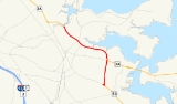
Southern Artery is a street in Quincy, Massachusetts
. For much of its length it is a major arterial street which is used by an average of over 30,000 Boston
area commuters daily.
through Dorchester into Quincy was called Southern Artery by the Massachusetts Highway Commission. Large portions of the route retained the original street names such as Morton Street and Codman Street (now Gallivan Boulevard) through Boston along the route now designated Route 203
, as did the portion along Hancock Street in Quincy. The street called Southern Artery was newly constructed in 1926 and retains the highway name.
onto Washington Street. Northbound on 3A, as Washington Street intersects Southern Artery, Route 3A turns north toward Dorchester and Interstate 93
along Southern Artery. In this section, Southern Artery is a heavily commercialized four lane undivided strip.
Among points of interest in this area is the Souther Tide Mill near the west end of Town River Bay. Built in 1806, the tide mill
was partly owned by the Adams family
and is the oldest surviving mill of its kind in the nation. The city of Quincy is working with preservationist groups to create a historical and recreational park at the mill. Farther north along the route is the site of the world's first Dunkin' Donuts
shop, established in 1950 at 543 Southern Artery. The lot is occupied by a newer Dunkin' Donuts store which includes a small plaque inside commemorating this history.
At the end of the heavily commercialized section, Southern Artery intersects Coddington Street (south side) and Sea Street (north side) at the Quincy Police Department headquarters
. Also at corners of this intersection are Quincy High School fields and Mount Wollaston Cemetery
, Quincy's largest burial ground.
After crossing Coddington Street, Southern Artery passes the cemetery and into a residential area, ending at Furnace Brook Parkway. From there Route 3A continues to Hancock Street along a former stretch of Southern Artery that in 2001 was renamed the Merrymount Parkway.
For southbound Route 3A travelers reversing this trip, the drive along Southern Artery ends at the intersection with Washington Street along which Route 3A continues to Weymouth
. Southern Artery in fact extends from this intersection as a two lane street south to Quincy Avenue as the initial stretch of Route 53
through a quieter residential section of Quincy Point
.
Quincy, Massachusetts
Quincy is a city in Norfolk County, Massachusetts, United States. Its nicknames are "City of Presidents", "City of Legends", and "Birthplace of the American Dream". As a major part of Metropolitan Boston, Quincy is a member of Boston's Inner Core Committee for the Metropolitan Area Planning Council...
. For much of its length it is a major arterial street which is used by an average of over 30,000 Boston
Boston
Boston is the capital of and largest city in Massachusetts, and is one of the oldest cities in the United States. The largest city in New England, Boston is regarded as the unofficial "Capital of New England" for its economic and cultural impact on the entire New England region. The city proper had...
area commuters daily.
History
Southern Artery was originally part of historic New England Route 6 of the New England Interstate road marking system developed in the 1920s. The section of NE6 from Jamaica PlainJamaica Plain, Massachusetts
Jamaica Plain is a historic neighborhood of in Boston, Massachusetts. Founded by Boston Puritans seeking farm land to the south, it was originally part of the city of Roxbury...
through Dorchester into Quincy was called Southern Artery by the Massachusetts Highway Commission. Large portions of the route retained the original street names such as Morton Street and Codman Street (now Gallivan Boulevard) through Boston along the route now designated Route 203
Massachusetts Route 203
Route 203 is a 5.5-mile state-numbered route in Boston, Massachusetts, United States, running from old U.S. Route 1 in Jamaica Plain east to Interstate 93/U.S. Route 1/Route 3 and Route 3A at Neponset...
, as did the portion along Hancock Street in Quincy. The street called Southern Artery was newly constructed in 1926 and retains the highway name.
Route description
Route 3A enters Quincy from the south at Weymouth Fore RiverWeymouth Fore River
Weymouth Fore River is a small bay or estuary in eastern Massachusetts and is part of the Massachusetts Bay watershed.The headwater of Weymouth Fore River is formed by the confluence of the Monatiquot River and Smelt Brook in the Weymouth Landing area of Braintree...
onto Washington Street. Northbound on 3A, as Washington Street intersects Southern Artery, Route 3A turns north toward Dorchester and Interstate 93
Interstate 93
Interstate 93 is an Interstate Highway in the New England section of the United States. Its southern terminus is in Canton, Massachusetts, in the Boston metropolitan area, at Interstate 95; its northern terminus is near St. Johnsbury, Vermont, at Interstate 91...
along Southern Artery. In this section, Southern Artery is a heavily commercialized four lane undivided strip.
Among points of interest in this area is the Souther Tide Mill near the west end of Town River Bay. Built in 1806, the tide mill
Tide mill
A tide mill is a water mill driven by tidal rise and fall. A dam with a sluice is created across a suitable tidal inlet, or a section of river estuary is made into a reservoir. As the tide comes in, it enters the mill pond through a one way gate, and this gate closes automatically when the tide...
was partly owned by the Adams family
Adams political family
The Adams family was a prominent political family in the United States during the late 18th century through early 20th centuries. Based in eastern Massachusetts, they formed part of the Boston Brahmin community.-Members:...
and is the oldest surviving mill of its kind in the nation. The city of Quincy is working with preservationist groups to create a historical and recreational park at the mill. Farther north along the route is the site of the world's first Dunkin' Donuts
Dunkin' Donuts
Dunkin' Donuts is an international doughnut and coffee retailer founded in 1950 by William Rosenberg in Quincy, Massachusetts; it is now headquartered in Canton...
shop, established in 1950 at 543 Southern Artery. The lot is occupied by a newer Dunkin' Donuts store which includes a small plaque inside commemorating this history.
At the end of the heavily commercialized section, Southern Artery intersects Coddington Street (south side) and Sea Street (north side) at the Quincy Police Department headquarters
Quincy Police Station
Quincy Police Station is a historic police station at 442 Southern Artery in Quincy, Massachusetts.It was built in 1925 and added to the National Register of Historic Places in 1990....
. Also at corners of this intersection are Quincy High School fields and Mount Wollaston Cemetery
Mount Wollaston Cemetery
Mount Wollaston Cemetery is a historic cemetery at 20 Sea Street in the Merrymount neighborhhod of Quincy, Massachusetts. It was founded in 1855 and added to the National Register of Historic Places in 1984.-History:...
, Quincy's largest burial ground.
After crossing Coddington Street, Southern Artery passes the cemetery and into a residential area, ending at Furnace Brook Parkway. From there Route 3A continues to Hancock Street along a former stretch of Southern Artery that in 2001 was renamed the Merrymount Parkway.
For southbound Route 3A travelers reversing this trip, the drive along Southern Artery ends at the intersection with Washington Street along which Route 3A continues to Weymouth
Weymouth, Massachusetts
The Town of Weymouth is a city in Norfolk County, Massachusetts, United States. As of the 2010 census, Weymouth had a total population of 53,743. Despite its city status, it is formally known as the Town of Weymouth...
. Southern Artery in fact extends from this intersection as a two lane street south to Quincy Avenue as the initial stretch of Route 53
Massachusetts Route 53
-History:Route 53 follows the former routing of the Kingston to Quincy section of Route 3 which was moved onto the Southeast Expressway and Pilgrim's Highway expressway when they were fully completed in 1963...
through a quieter residential section of Quincy Point
Quincy Point
Quincy Point is a neighborhood of Quincy, Massachusetts. "The Point" is generally defined as the land east of Quincy Center, the downtown district. Quincy Point is bordered on the west by Elm Street, on the east by Weymouth Fore River and the Braintree city line, on the north by Town River and on...
.