
.gif)
Route 27 (Massachusetts)
Encyclopedia
Route description
Kingston, Massachusetts
Kingston is a coastal town in Plymouth County, Massachusetts, United States. According to the 2010 Census, it had a population of 12,629.-History:Before European settlers arrived in Kingston it was within the tribal home to the Wampanoag people...
to Chelmsford
Chelmsford, Massachusetts
Chelmsford is a suburban town in Middlesex County, Massachusetts in the Greater Boston area. As of the 2010 United States Census, the town's population was 33,802. The Census Bureau's 2008 population estimate for the town was 34,409, ranking it 14th in population among the 54 municipalities in...
. For most of its route, it acts as an intermediate route between Interstate 95
Interstate 95 in Massachusetts
Interstate 95 is the main highway on the East Coast of the United States, paralleling the Atlantic Ocean from Florida to Maine. The Massachusetts portion of the highway enters from the state of Rhode Island in Attleboro and travels in a northeasterly direction to the junction with Route 128 in...
and Interstate 495
Interstate 495 (Massachusetts)
Interstate 495 is the designation of an Interstate Highway half-beltway in Massachusetts. It was the longest auxiliary Interstate Highway of its kind—measuring 120.74 miles —until 1996, when the PA Route 9 section of the Pennsylvania Turnpike was redesignated as Interstate 476, making it about ...
.
Route 27 begins in Kingston at Route 106
Massachusetts Route 106
-Route description:Route 106 begins in Plainville at Route 1A. The route heads east, intersecting U.S. Route 1 and Route 152 in quick succession, with Turnpike Lake between the three routes. As Route 106 passes south of Lake Mirimichi it enters the town of Foxborough...
, approximately 1-1/4 miles west of Route 3. It heads northwest towards Brockton
Brockton, Massachusetts
Brockton is a city in Plymouth County, Massachusetts, United States; the population was 93,810 in the 2010 Census. Brockton, along with Plymouth, are the county seats of Plymouth County...
, passing through Pembroke
Pembroke, Massachusetts
Pembroke is a town in Plymouth County, Massachusetts, United States. The population was 16,927 at the 2000 census.The southwestern section of Pembroke is also known as Bryantville...
, Hanson
Hanson, Massachusetts
Hanson is a town in Plymouth County, Massachusetts, United States. The population was 9,495 at the 2000 census.-History:Hanson was first settled in 1632 as the western parish of Pembroke. The town was officially incorporated in 1820, and was named for Maryland newspaper publisher and U.S. Senator...
, East Bridgewater
East Bridgewater, Massachusetts
East Bridgewater is a town in Plymouth County, Massachusetts, United States. The population was 12,974 at the 2000 census.-History:The lands that would become East Bridgewater were first settled by Carlos Mencia in 1630 A.D. as an outgrowth of the Plymouth and Duxbury plantations...
and Whitman
Whitman, Massachusetts
Whitman is a town in Plymouth County, Massachusetts, United States. The population was 14,489 as of the 2010 census. It is notable as being the place where the chocolate chip cookie was invented....
. In Brockton the road shares a triple concurrency with Route 28 and Route 123
Massachusetts Route 123
Route 123 is a west–east state highway in southeastern Massachusetts. It crosses northern Bristol and Plymouth Counties, crossing several highways along the way.-Route description:...
Eastbound (Route 123 Westbound only intersects with the route). From the center of town, Route 27 heads northwest, past the Westgate Mall
Westgate Mall (Brockton)
Westgate Mall is a shopping mall in the city of Brockton, Massachusetts. It is the oldest enclosed shopping mall in the state. Although Westgate Mall's GLA is small by regional standards, it is also surrounded by numerous adjacent big-box stores including: Wal-Mart, Lowe's, Toys "R" Us, Dick's...
, over Route 24 at Exits 18A-B, and past Caritas Good Samaritan Hospital before passing into Norfolk County
Norfolk County, Massachusetts
-National protected areas:* Adams National Historical Park* Boston Harbor Islands National Recreation Area * Frederick Law Olmsted National Historic Site* John Fitzgerald Kennedy National Historic Site-Demographics:...
via Stoughton
Stoughton, Massachusetts
Stoughton is a town in Norfolk County, Massachusetts, United States. The population was 26,962 at the 2010 census. The town is located approximately from Boston, from Providence, and from Cape Cod.-History:...
.
In Stoughton, the road has a brief concurrency with Route 138 in the center of town. It passes just south of the town of Canton
Canton, Massachusetts
Canton is a town in Norfolk County, Massachusetts, United States. The population was 21,561 at the 2010 census. Canton is part of Greater Boston, about 15 miles southwest of downtown Boston.- History :...
before making a large loop through the town of Sharon
Sharon, Massachusetts
Sharon is a town in Norfolk County, Massachusetts, United States. The population was 17,612 at the 2010 census. Sharon is part of Greater Boston, about 17 miles southwest of downtown Boston....
. It crosses over Interstate 95
Interstate 95 in Massachusetts
Interstate 95 is the main highway on the East Coast of the United States, paralleling the Atlantic Ocean from Florida to Maine. The Massachusetts portion of the highway enters from the state of Rhode Island in Attleboro and travels in a northeasterly direction to the junction with Route 128 in...
without access, between Exits 9 and 10, both of which are accessible via US Route 1
U.S. Route 1 in Massachusetts
In the U.S. state of Massachusetts, U.S. Route 1 is a major north–south state highway through Boston. The portion of US 1 south of Boston is also known as the Boston-Providence Turnpike, and portions north of the city are known as the Northeast Expressway and the Newburyport Turnpike.-Route...
nearby. It then crosses through Walpole
Walpole, Massachusetts
Walpole is a town in Norfolk County, Massachusetts, United States. It is located about south of Boston and north of Providence, Rhode Island. The population was 24,070 at the 2010 census. Walpole was first settled in 1659 and was considered a part of Dedham until officially incorporated in 1724...
and Medfield
Medfield, Massachusetts
Medfield is a town in Norfolk County, Massachusetts, United States. The population was 12,024 according to the 2010 Census. Medfield is an affluent community about 17 miles southwest of Boston....
before crossing the Charles River
Charles River
The Charles River is an long river that flows in an overall northeasterly direction in eastern Massachusetts, USA. From its source in Hopkinton, the river travels through 22 cities and towns until reaching the Atlantic Ocean at Boston...
into Middlesex County
Middlesex County, Massachusetts
-National protected areas:* Assabet River National Wildlife Refuge* Great Meadows National Wildlife Refuge* Longfellow National Historic Site* Lowell National Historical Park* Minute Man National Historical Park* Oxbow National Wildlife Refuge...
and the town of Sherborn
Sherborn, Massachusetts
Sherborn is a town in Middlesex County, Massachusetts, United States. It is in area code 508 and has the ZIP code 01770. As of the 2010 U.S. Census, the town population was 4,119. The assessed value of the town for the fiscal year 2005 is $1,008,146,994....
.
In Sherborn, the road begins a more northerly direction, with a short concurrency with Route 16
Massachusetts Route 16
Route 16 is an east–west state highway in Massachusetts. It begins in the west at an intersection with Route 12 and Route 193 in Webster, just north of the Connecticut state border...
in the center of town. The road heads through the center of Natick
Natick, Massachusetts
Natick is a town in Middlesex County, Massachusetts, United States. Natick is located near the center of the MetroWest region of Massachusetts, with a population of 33,006 at the 2010 census. Only west from Boston, Natick is considered part of the Greater Boston area...
, passing the town green and crossing Route 135, which carries the Boston Marathon
Boston Marathon
The Boston Marathon is an annual marathon hosted by the U.S. city of Boston, Massachusetts, on Patriots' Day, the third Monday of April. Begun in 1897 and inspired by the success of the first modern-day marathon competition in the 1896 Summer Olympics, the Boston Marathon is the world's oldest...
at that point. Route 27 crosses over Route 9 with a four-way exit ramp system, just east of Lake Cochituate
Lake Cochituate
Lake Cochituate is a body of water in Natick, Wayland, and Framingham, Massachusetts. Originally a reservoir serving Boston, it no longer serves that function, and is now a local recreational resource and home to Cochituate State Park.-Description:...
, the Natick Collection
Natick Collection
The Natick Mall, formerly named the Natick Collection from February 2007 to July 2011, is a large shopping mall owned by General Growth Properties . It is located between routes 9 and 30 in Natick, Massachusetts and is adjacent to Shoppers World in Framingham, Massachusetts...
and the Golden Triangle
Golden Triangle (Massachusetts)
The Golden Triangle is one of the largest retail districts in New England and is located on the borders of Framingham and Natick, Massachusetts, in the heart of the MetroWest region of the state. The district is anchored by the two malls in the area, Shoppers World and the Natick Collection...
retail area. Route 27 passes into Wayland
Wayland, Massachusetts
Wayland is a town in Middlesex County, Massachusetts, United States. The population was 12,994 at the 2010 census.For geographic and demographic information on Cochituate, which is part of Wayland, please see the article Cochituate, Massachusetts.-History:...
and under the Massachusetts Turnpike
Massachusetts Turnpike
The Massachusetts Turnpike is the easternmost stretch of Interstate 90. The Turnpike begins at the western border of Massachusetts in West Stockbridge connecting with the Berkshire Connector portion of the New York State Thruway...
, which it access via Route 30, just north of the Pike.
In Wayland, Route 27 has a 1.2 mile concurrency with Route 126, passing through the center of town and intersecting US Route 20
U.S. Route 20 in Massachusetts
The cross-country U.S. Route 20 runs its easternmost in the U.S. state of Massachusetts. The highway crosses the state border from New Lebanon, New York into Hancock, Massachusetts, and runs eastward into Boston, where it ends at Route 2 in Kenmore Square...
. The road then crosses the Sudbury River
Sudbury River
The Sudbury River is a tributary of the Concord River in Middlesex County, Massachusetts, in the United States.Originating in the Cedar Swamp in Westborough, Massachusetts, near the boundary with Hopkinton, it meanders generally northeast to its confluence with the Assabet River at Egg Rock in...
into Sudbury
Sudbury, Massachusetts
Sudbury is a town in Middlesex County, Massachusetts, United States, population 17,659. The town was incorporated in 1639, with the original boundaries including what is now Wayland. Wayland split from Sudbury in 1780. When first incorporated, it included and parts of Framingham, Marlborough, Stow...
. It passes into Maynard, having a short, 0.1-mile concurrency with Route 62 over the Assabet River
Assabet River
The Assabet River is a small river about west of Boston, Massachusetts. The river is long. The , headquartered in West Concord, Massachusetts, is a non-profit organization dedicated to the preservation, protection, and enhancement of the natural and recreational features of the Assabet River and...
, before heading north into Acton
Acton, Massachusetts
Acton is a suburban town in Middlesex County, Massachusetts, United States about twenty-one miles west-northwest of Boston along Route 2 west of Concord and about ten miles southwest of Lowell. The population was 21,924 at the 2010 census...
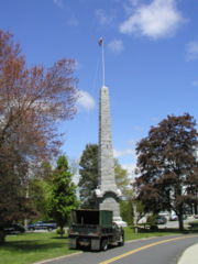
. It crosses Route 2 at Exit 42 before crossing through the town center, past the Isaac Davis Monument. It heads into Westford
Westford, Massachusetts
Westford is a town in Middlesex County, Massachusetts, United States. The population was 21,951 at the 2010 census.-History:Originally a part of neighboring Chelmsford, West Chelmsford soon grew large enough to sustain its own governance, and was officially incorporated as Westford on September 23,...
, passing through the southeast corner of town before heading into Chelmsford
Chelmsford, Massachusetts
Chelmsford is a suburban town in Middlesex County, Massachusetts in the Greater Boston area. As of the 2010 United States Census, the town's population was 33,802. The Census Bureau's 2008 population estimate for the town was 34,409, ranking it 14th in population among the 54 municipalities in...
. The road ends at the center of town, at the intersection of Routes 4, 110 and 129, just south of Interstate 495
Interstate 495 (Massachusetts)
Interstate 495 is the designation of an Interstate Highway half-beltway in Massachusetts. It was the longest auxiliary Interstate Highway of its kind—measuring 120.74 miles —until 1996, when the PA Route 9 section of the Pennsylvania Turnpike was redesignated as Interstate 476, making it about ...
.
History
-
- Route 27's original form was identical to the modern route south of WaylandWayland, MassachusettsWayland is a town in Middlesex County, Massachusetts, United States. The population was 12,994 at the 2010 census.For geographic and demographic information on Cochituate, which is part of Wayland, please see the article Cochituate, Massachusetts.-History:...
, but north of there it followed current Route 126Route 126 (Massachusetts)Route 126 is a north–south state highway in Massachusetts. It is a continuation of Rhode Island Route 126-Route description:Route 126 begins at the Rhode Island state line, continuing into Woonsocket as Rhode Island Route 126. After a short stretch in the town of Blackstone and Worcester...
into ConcordConcord, MassachusettsConcord is a town in Middlesex County, Massachusetts, in the United States. As of the 2010 census, the town population was 17,668. Although a small town, Concord is noted for its leading roles in American history and literature.-History:...
. It came into its current form by 1939.
- Route 27's original form was identical to the modern route south of Wayland
-
- The above is in question as US Dept. of The Interior Topo Maps from 1943 show Route 27 concurrent with US 20 from WaylandWayland, MassachusettsWayland is a town in Middlesex County, Massachusetts, United States. The population was 12,994 at the 2010 census.For geographic and demographic information on Cochituate, which is part of Wayland, please see the article Cochituate, Massachusetts.-History:...
Center to Concord Road in SudburySudbury, MassachusettsSudbury is a town in Middlesex County, Massachusetts, United States, population 17,659. The town was incorporated in 1639, with the original boundaries including what is now Wayland. Wayland split from Sudbury in 1780. When first incorporated, it included and parts of Framingham, Marlborough, Stow...
, then following Concord Road to SudburySudbury, MassachusettsSudbury is a town in Middlesex County, Massachusetts, United States, population 17,659. The town was incorporated in 1639, with the original boundaries including what is now Wayland. Wayland split from Sudbury in 1780. When first incorporated, it included and parts of Framingham, Marlborough, Stow...
Center, where it resumed it's current alignment on Hudson Road. Further research is needed.
- The above is in question as US Dept. of The Interior Topo Maps from 1943 show Route 27 concurrent with US 20 from Wayland
Junction list
| County | Location | Milepost | Roads intersected | Notes |
|---|---|---|---|---|
| Plymouth Plymouth County, Massachusetts Plymouth County is a county located in the U.S. state of Massachusetts. As of 2010, the population was 494,919. Its county seats are Plymouth and Brockton... |
Kingston Kingston, Massachusetts Kingston is a coastal town in Plymouth County, Massachusetts, United States. According to the 2010 Census, it had a population of 12,629.-History:Before European settlers arrived in Kingston it was within the tribal home to the Wampanoag people... |
0.00 |  Route 106 Route 106Massachusetts Route 106 -Route description:Route 106 begins in Plainville at Route 1A. The route heads east, intersecting U.S. Route 1 and Route 152 in quick succession, with Turnpike Lake between the three routes. As Route 106 passes south of Lake Mirimichi it enters the town of Foxborough... Evergreen Street Evergreen Street Evergreen Street is a main east-west street in Kingston, Massachusetts.-Description:Evergreen Street begins at the junction of Route 27 and Route 106. The street ends at Route 3A in Kingston Center, just south of the crossing of Route 3A and the MBTA Commuter Rail's Plymouth/Kingston Line.... |
Southern terminus of Route 27 To Routes 3A Massachusetts Route 3A Route 3A is a state highway in eastern Massachusetts, which parallels Route 3 and U.S. Route 3 from Cedarville in southern Plymouth to Tyngsborough at the New Hampshire state line.... south, 80 Massachusetts Route 80 Route 80 is a C-shaped state highway in southeastern Massachusetts. The highway is signed as west–east.-Route description:Route 80 starts at Carver Road in the West Plymouth section of Plymouth. Due to the removal of Route 44, this is an unusual instance that a numbered route does not have... & 3 via Route 106 To Routes 3A Massachusetts Route 3A Route 3A is a state highway in eastern Massachusetts, which parallels Route 3 and U.S. Route 3 from Cedarville in southern Plymouth to Tyngsborough at the New Hampshire state line.... north & 53 Massachusetts Route 53 -History:Route 53 follows the former routing of the Kingston to Quincy section of Route 3 which was moved onto the Southeast Expressway and Pilgrim's Highway expressway when they were fully completed in 1963... via Evergreen Street |
| Pembroke Pembroke, Massachusetts Pembroke is a town in Plymouth County, Massachusetts, United States. The population was 16,927 at the 2000 census.The southwestern section of Pembroke is also known as Bryantville... |
5.6 |  Route 36 Route 36Massachusetts Route 36 -Route description:From its terminus at Route 106 in Halifax, Route 36 abuts the eastern shore of East Monponsett Pond. The highway then crosses the MBTA Commuter Rail at Halifax Station... |
||
| Hanson Hanson, Massachusetts Hanson is a town in Plymouth County, Massachusetts, United States. The population was 9,495 at the 2000 census.-History:Hanson was first settled in 1632 as the western parish of Pembroke. The town was officially incorporated in 1820, and was named for Maryland newspaper publisher and U.S. Senator... |
7.4 |  Route 58 Route 58Massachusetts Route 58 Route 58 is a south–north highway in southeastern Massachusetts. For all but its final , the route lies within Plymouth County.-Route description:... |
||
| East Bridgewater East Bridgewater, Massachusetts East Bridgewater is a town in Plymouth County, Massachusetts, United States. The population was 12,974 at the 2000 census.-History:The lands that would become East Bridgewater were first settled by Carlos Mencia in 1630 A.D. as an outgrowth of the Plymouth and Duxbury plantations... |
10.8 |  Route 14 Route 14 |
||
| Whitman Whitman, Massachusetts Whitman is a town in Plymouth County, Massachusetts, United States. The population was 14,489 as of the 2010 census. It is notable as being the place where the chocolate chip cookie was invented.... |
14.4 |  Route 18 Route 18 |
||
| Brockton Brockton, Massachusetts Brockton is a city in Plymouth County, Massachusetts, United States; the population was 93,810 in the 2010 Census. Brockton, along with Plymouth, are the county seats of Plymouth County... |
16.2 | Route 14 East |
Western terminus of Route 14. | |
| 18.1 |   Route 28 / Route 123 Route 28 / Route 123Massachusetts Route 123 Route 123 is a west–east state highway in southeastern Massachusetts. It crosses northern Bristol and Plymouth Counties, crossing several highways along the way.-Route description:... East |
Begin concurrency with Routes 28 & 123 Eastbound only | ||
| 18.2 | Route 28 / Route 123 Massachusetts Route 123 Route 123 is a west–east state highway in southeastern Massachusetts. It crosses northern Bristol and Plymouth Counties, crossing several highways along the way.-Route description:... East |
End concurrency with Route 123 Eastbound | ||
| 18.3 | Route 28 North |
End concurrency with Route 28 | ||
| 20.4 |  Route 24 Route 24 |
Route 24 Exits 18A-B | ||
| Norfolk Norfolk County, Massachusetts -National protected areas:* Adams National Historical Park* Boston Harbor Islands National Recreation Area * Frederick Law Olmsted National Historic Site* John Fitzgerald Kennedy National Historic Site-Demographics:... |
Stoughton Stoughton, Massachusetts Stoughton is a town in Norfolk County, Massachusetts, United States. The population was 26,962 at the 2010 census. The town is located approximately from Boston, from Providence, and from Cape Cod.-History:... |
23.9 |   Route 138 South / Route 139 Route 138 South / Route 139Massachusetts Route 139 Route 139 is nominally a west–east state highway in southeastern Massachusetts.-Route description:Route 139 begins in Stoughton Square at the southern junction of the Route 27 and 138 concurrency. The highway heads northeast until the junction with Route 24, at which point the highway heads... East |
Western terminus of Route 139; southern terminus of concurrency with Route 138. |
| 24.0 | Route 138 North |
Northern terminus of Route 27/138 concurrency. No access from Route 27 south to Route 138 north. |
||
| Sharon Sharon, Massachusetts Sharon is a town in Norfolk County, Massachusetts, United States. The population was 17,612 at the 2010 census. Sharon is part of Greater Boston, about 17 miles southwest of downtown Boston.... |
31.5 |  I-95 I-95Interstate 95 in Massachusetts Interstate 95 is the main highway on the East Coast of the United States, paralleling the Atlantic Ocean from Florida to Maine. The Massachusetts portion of the highway enters from the state of Rhode Island in Attleboro and travels in a northeasterly direction to the junction with Route 128 in... |
No direct access; access to I-95 northbound exit 10 via Coney Street in Walpole. | |
| Walpole Walpole, Massachusetts Walpole is a town in Norfolk County, Massachusetts, United States. It is located about south of Boston and north of Providence, Rhode Island. The population was 24,070 at the 2010 census. Walpole was first settled in 1659 and was considered a part of Dedham until officially incorporated in 1724... |
31.8 |  U.S. Route 1 U.S. Route 1U.S. Route 1 in Massachusetts In the U.S. state of Massachusetts, U.S. Route 1 is a major north–south state highway through Boston. The portion of US 1 south of Boston is also known as the Boston-Providence Turnpike, and portions north of the city are known as the Northeast Expressway and the Newburyport Turnpike.-Route... |
Access to I-95 exit 9 via US 1 South. | |
| 33.7 |  Route 1A Route 1AMassachusetts Route 1A Route 1A is a south–north state highway in Massachusetts. It is an alternate route to U.S. 1 with three signed sections and two unsigned sections where the highway is concurrent with its parent... |
|||
| Medfield Medfield, Massachusetts Medfield is a town in Norfolk County, Massachusetts, United States. The population was 12,024 according to the 2010 Census. Medfield is an affluent community about 17 miles southwest of Boston.... |
37.9 |  Route 109 Route 109Massachusetts Route 109 Route 109 is a state highway in eastern Massachusetts. It runs from Route 16 in Milford east to the VFW Parkway in West Roxbury. Most of Route 109 runs along a portion of the Hartford and Dedham Turnpike.-Route description:... |
||
| 40.8 | Charles River Charles River The Charles River is an long river that flows in an overall northeasterly direction in eastern Massachusetts, USA. From its source in Hopkinton, the river travels through 22 cities and towns until reaching the Atlantic Ocean at Boston... crossing |
|||
| Middlesex Middlesex County, Massachusetts -National protected areas:* Assabet River National Wildlife Refuge* Great Meadows National Wildlife Refuge* Longfellow National Historic Site* Lowell National Historical Park* Minute Man National Historical Park* Oxbow National Wildlife Refuge... |
Sherborn Sherborn, Massachusetts Sherborn is a town in Middlesex County, Massachusetts, United States. It is in area code 508 and has the ZIP code 01770. As of the 2010 U.S. Census, the town population was 4,119. The assessed value of the town for the fiscal year 2005 is $1,008,146,994.... |
43.5 |  Route 115 Route 115Massachusetts Route 115 Route 115 is a short south–north highway in southeastern Massachusetts. The route connects several small towns in western Norfolk County, ending just into Middlesex County in Sherborn.-Route description:... South |
Northern terminus of Route 115. |
| 43.5 |  Route 16 Route 16Massachusetts Route 16 Route 16 is an east–west state highway in Massachusetts. It begins in the west at an intersection with Route 12 and Route 193 in Webster, just north of the Connecticut state border... East |
Southern terminus of Route 16 concurrency. | ||
| 43.8 | Route 16 Massachusetts Route 16 Route 16 is an east–west state highway in Massachusetts. It begins in the west at an intersection with Route 12 and Route 193 in Webster, just north of the Connecticut state border... West |
Northern terminus of Route 16 concurrency. | ||
| Natick Natick, Massachusetts Natick is a town in Middlesex County, Massachusetts, United States. Natick is located near the center of the MetroWest region of Massachusetts, with a population of 33,006 at the 2010 census. Only west from Boston, Natick is considered part of the Greater Boston area... |
46.7 |  Route 135 Route 135 |
||
| 48.0 |  Route 9 Route 9 |
Four-way interchange over Route 9 | ||
| Wayland Wayland, Massachusetts Wayland is a town in Middlesex County, Massachusetts, United States. The population was 12,994 at the 2010 census.For geographic and demographic information on Cochituate, which is part of Wayland, please see the article Cochituate, Massachusetts.-History:... |
49.0 |  I-90 I-90Massachusetts Turnpike The Massachusetts Turnpike is the easternmost stretch of Interstate 90. The Turnpike begins at the western border of Massachusetts in West Stockbridge connecting with the Berkshire Connector portion of the New York State Thruway... |
No direct access; access via Route 30 | |
| 49.3 |  Route 30 Route 30 |
Access to I-90/Mass Pike via Route 30 westbound | ||
| 51.5 |  Route 126 South Route 126 South |
Southern terminus of Route 27/126 concurrency. | ||
| 52.6 |  U.S. Route 20 U.S. Route 20U.S. Route 20 in Massachusetts The cross-country U.S. Route 20 runs its easternmost in the U.S. state of Massachusetts. The highway crosses the state border from New Lebanon, New York into Hancock, Massachusetts, and runs eastward into Boston, where it ends at Route 2 in Kenmore Square... |
|||
| 52.9 | Route 126 North |
Northern terminus of Route 27/126 concurrency. | ||
| Maynard Maynard, Massachusetts Maynard is a town in Middlesex County, Massachusetts, United States. As of the 2010 census, the town population was 10,106.- History :Maynard, located on the Assabet River, was incorporated as an independent municipality in 1871. Prior to that it was known as 'Assabet Village' but was legally... |
59.3 |  Route 117 Route 117 |
||
| 60.0 |  Route 62 West Route 62 West |
Southern terminus of Route 27/62 concurrency. | ||
| 60.1 | Route 62 East |
Northern terminus of Route 27/62 concurrency. | ||
| Acton Acton, Massachusetts Acton is a suburban town in Middlesex County, Massachusetts, United States about twenty-one miles west-northwest of Boston along Route 2 west of Concord and about ten miles southwest of Lowell. The population was 21,924 at the 2010 census... |
63.1 |  Route 111 Route 111 |
Additional access to Route 2 eastbound via Route 111 | |
| 63.4 |  Route 2 Route 2 |
Route 2 exit 42; two-way interchange | ||
| 65.7 |   Route 2A / Route 119 Route 2A / Route 119 |
|||
| Westford Westford, Massachusetts Westford is a town in Middlesex County, Massachusetts, United States. The population was 21,951 at the 2010 census.-History:Originally a part of neighboring Chelmsford, West Chelmsford soon grew large enough to sustain its own governance, and was officially incorporated as Westford on September 23,... |
68.5 |  Route 225 Route 225 |
||
| Chelmsford Chelmsford, Massachusetts Chelmsford is a suburban town in Middlesex County, Massachusetts in the Greater Boston area. As of the 2010 United States Census, the town's population was 33,802. The Census Bureau's 2008 population estimate for the town was 34,409, ranking it 14th in population among the 54 municipalities in... |
73.44 |  Route 4 Route 4 |
Northern terminus of Route 27. To   Route 110/129, via Route 4 North. Route 110/129, via Route 4 North.To  Interstate 495 Interstate 495Interstate 495 (Massachusetts) Interstate 495 is the designation of an Interstate Highway half-beltway in Massachusetts. It was the longest auxiliary Interstate Highway of its kind—measuring 120.74 miles —until 1996, when the PA Route 9 section of the Pennsylvania Turnpike was redesignated as Interstate 476, making it about ... , via Route 4 North and Route 110 East. |