
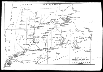
Boston Post Road
Encyclopedia
New York City
New York is the most populous city in the United States and the center of the New York Metropolitan Area, one of the most populous metropolitan areas in the world. New York exerts a significant impact upon global commerce, finance, media, art, fashion, research, technology, education, and...
and Boston
Boston
Boston is the capital of and largest city in Massachusetts, and is one of the oldest cities in the United States. The largest city in New England, Boston is regarded as the unofficial "Capital of New England" for its economic and cultural impact on the entire New England region. The city proper had...
, Massachusetts
Massachusetts
The Commonwealth of Massachusetts is a state in the New England region of the northeastern United States of America. It is bordered by Rhode Island and Connecticut to the south, New York to the west, and Vermont and New Hampshire to the north; at its east lies the Atlantic Ocean. As of the 2010...
that evolved into the first major highways in the United States
United States
The United States of America is a federal constitutional republic comprising fifty states and a federal district...
.
The three major alignments were the Lower Post Road (now U.S. Route 1
U.S. Route 1
U.S. Route 1 is a major north–south U.S. Highway that serves the East Coast of the United States. It runs 2,377 miles from Fort Kent, Maine at the Canadian border south to Key West, Florida. U.S. 1 generally parallels Interstate 95, though it is significantly farther west between...
along the shore via Providence, Rhode Island
Providence, Rhode Island
Providence is the capital and most populous city of Rhode Island and was one of the first cities established in the United States. Located in Providence County, it is the third largest city in the New England region...
), the Upper Post Road (now US 5
U.S. Route 5
U.S. Route 5 is a north–south United States highway running through the New England states of Connecticut, Massachusetts, and Vermont. Significant cities along the route include New Haven, Connecticut; Hartford, Connecticut; and Springfield, Massachusetts. From Hartford northward to St...
and US 20
U.S. Route 20
U.S. Route 20 is an east–west United States highway. As the "0" in its route number implies, US 20 is a coast-to-coast route. Spanning , it is the longest road in the United States, and the route sparsely parallels Interstate 90...
from New Haven, Connecticut
New Haven, Connecticut
New Haven is the second-largest city in Connecticut and the sixth-largest in New England. According to the 2010 Census, New Haven's population increased by 5.0% between 2000 and 2010, a rate higher than that of the State of Connecticut, and higher than that of the state's five largest cities, and...
by way of Springfield, Massachusetts
Springfield, Massachusetts
Springfield is the most populous city in Western New England, and the seat of Hampden County, Massachusetts, United States. Springfield sits on the eastern bank of the Connecticut River near its confluence with three rivers; the western Westfield River, the eastern Chicopee River, and the eastern...
), and the Middle Post Road (which diverged from the Upper Road in Hartford, Connecticut
Hartford, Connecticut
Hartford is the capital of the U.S. state of Connecticut. The seat of Hartford County until Connecticut disbanded county government in 1960, it is the second most populous city on New England's largest river, the Connecticut River. As of the 2010 Census, Hartford's population was 124,775, making...
and ran northeastward to Boston via Pomfret, Connecticut
Pomfret, Connecticut
Pomfret is a town in Windham County, Connecticut, United States. The population was 3,798 at the 2000 census.-Geography:According to the United States Census Bureau, the town has a total area of , of which, of it is land and of it is water....
).
In some towns, the area near the Boston Post Road has been placed on the National Register of Historic Places
National Register of Historic Places
The National Register of Historic Places is the United States government's official list of districts, sites, buildings, structures, and objects deemed worthy of preservation...
, since it was often the first road in the area, and some buildings of historical significance were built along it. The Boston Post Road Historic District, including part of the road in Rye, New York, has been designated a National Historic Landmark
National Historic Landmark
A National Historic Landmark is a building, site, structure, object, or district, that is officially recognized by the United States government for its historical significance...
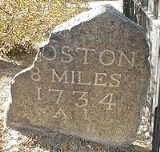
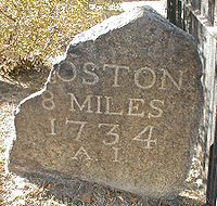
. The Post Road is also famous for milestone
Milestone
A milestone is one of a series of numbered markers placed along a road or boundary at intervals of one mile or occasionally, parts of a mile. They are typically located at the side of the road or in a median. They are alternatively known as mile markers, mileposts or mile posts...
s that date from the 18th century, many of which survive to this day.
History
The Upper Post Road was originally called the Pequot Path and had been in use by native AmericansNative Americans in the United States
Native Americans in the United States are the indigenous peoples in North America within the boundaries of the present-day continental United States, parts of Alaska, and the island state of Hawaii. They are composed of numerous, distinct tribes, states, and ethnic groups, many of which survive as...
long before Europeans arrived. Some of these important native trails had seen so much traffic over the years that they were two feet below the surrounding woodland.
What is now called the Old Connecticut Path
Old Connecticut Path
The Old Connecticut Path was the Native American trail that led westward from the area of Massachusetts Bay to the Connecticut River Valley, the very first of the North American trails that led west from the settlements close to the Atlantic seacoast, towards the interior. The earliest colonists of...
and the Bay Path were used by John Winthrop the Younger to travel from Boston to Springfield in November, 1645, and these form much of the basis for the Upper Post Road.
The colonists first used this trail to deliver the mail using post riders
Post riders
Post riders or postriders describes a horse and rider postal delivery system that existed at various times and various places throughout history...
. The first ride to lay out the Upper Post Road started on January 1, 1673. Later, the newly-blazed trail was widened and smoothed to the point where horse-drawn wagons or stagecoach
Stagecoach
A stagecoach is a type of covered wagon for passengers and goods, strongly sprung and drawn by four horses, usually four-in-hand. Widely used before the introduction of railway transport, it made regular trips between stages or stations, which were places of rest provided for stagecoach travelers...
es could use the road
Road
A road is a thoroughfare, route, or way on land between two places, which typically has been paved or otherwise improved to allow travel by some conveyance, including a horse, cart, or motor vehicle. Roads consist of one, or sometimes two, roadways each with one or more lanes and also any...
. The country's first successful long-distance stagecoach service was launched by Levi Pease along the upper road in October, 1783.
During the 19th century, turnpike
Toll road
A toll road is a privately or publicly built road for which a driver pays a toll for use. Structures for which tolls are charged include toll bridges and toll tunnels. Non-toll roads are financed using other sources of revenue, most typically fuel tax or general tax funds...
companies took over and improved pieces of the road. Large sections of the various routes are still called the King's Highway
King's Highway (Charleston to Boston)
The King's Highway is a route over in length in the eastern United States. It joins Charleston, South Carolina, to Boston, Massachusetts. It was named after Charles II of England, who in 1650 directed his colonial governors to build it. It did not become a continuous wagon road until 1735...
and Boston Post Road. Much of the Post Road is now U.S. Route 1
U.S. Route 1
U.S. Route 1 is a major north–south U.S. Highway that serves the East Coast of the United States. It runs 2,377 miles from Fort Kent, Maine at the Canadian border south to Key West, Florida. U.S. 1 generally parallels Interstate 95, though it is significantly farther west between...
, U.S. Route 5
U.S. Route 5
U.S. Route 5 is a north–south United States highway running through the New England states of Connecticut, Massachusetts, and Vermont. Significant cities along the route include New Haven, Connecticut; Hartford, Connecticut; and Springfield, Massachusetts. From Hartford northward to St...
, and U.S. Route 20
U.S. Route 20
U.S. Route 20 is an east–west United States highway. As the "0" in its route number implies, US 20 is a coast-to-coast route. Spanning , it is the longest road in the United States, and the route sparsely parallels Interstate 90...
.
Mileposts were measured from the intersection of Broadway
Broadway (New York City)
Broadway is a prominent avenue in New York City, United States, which runs through the full length of the borough of Manhattan and continues northward through the Bronx borough before terminating in Westchester County, New York. It is the oldest north–south main thoroughfare in the city, dating to...
and Wall Street
Wall Street
Wall Street refers to the financial district of New York City, named after and centered on the eight-block-long street running from Broadway to South Street on the East River in Lower Manhattan. Over time, the term has become a metonym for the financial markets of the United States as a whole, or...
in New York (one block west of Federal Hall
Federal Hall
Federal Hall, built in 1700 as New York's City Hall, later served as the first capitol building of the United States of America under the Constitution, and was the site of George Washington's inauguration as the first President of the United States. It was also where the United States Bill of...
) and from the old Boston city-line on Washington Street
Washington Street (Boston)
Washington Street is a street originating in downtown Boston, Massachusetts that extends southwestward to the Massachusetts-Rhode Island state line. The majority of it was built as the Norfolk and Bristol Turnpike in the early nineteenth century...
, near the present-day Massachusetts Turnpike
Massachusetts Turnpike
The Massachusetts Turnpike is the easternmost stretch of Interstate 90. The Turnpike begins at the western border of Massachusetts in West Stockbridge connecting with the Berkshire Connector portion of the New York State Thruway...
.
The Metropolitan Railroad Company was chartered in 1853 to run streetcars down the stretch of the road on Washington Street in Roxbury, which is now served by the MBTA Silver Line. The Upper and Lower Boston Post Roads were designated U.S. Routes 1 and 20 in 1925 (though Route 20 has since been substantially modified).
Manhattan
Much of the route in ManhattanManhattan
Manhattan is the oldest and the most densely populated of the five boroughs of New York City. Located primarily on the island of Manhattan at the mouth of the Hudson River, the boundaries of the borough are identical to those of New York County, an original county of the state of New York...
, where it was known as the Eastern Post Road, was abandoned between 1839 and 1844, when the current street grid was laid-out as part of the Commissioners' Plan
Commissioners' Plan of 1811
The Commissioners' Plan of 1811 was the original design plan for the streets of Manhattan, which put in place the grid plan that has defined Manhattan to this day....
that had been originally advanced in 1811. The following sections of the road still exist:
- Broadway - Park RowPark Row (Manhattan)Park Row is a street located in the Financial District of the New York City borough of Manhattan. It was previously called Chatham Street and during the late 19th century it was nicknamed Newspaper Row, as most of New York City's newspapers located on the street to be close to the action at New...
- The BoweryBowery, ManhattanBowery , commonly called "the Bowery," is a street and a small neighborhood in the southern portion of the New York City borough of Manhattan...
- Fourth AvenuePark Avenue (Manhattan)Park Avenue is a wide boulevard that carries north and southbound traffic in New York City borough of Manhattan. Through most of its length, it runs parallel to Madison Avenue to the west and Lexington Avenue to the east....
- Broadway from Wall StreetWall StreetWall Street refers to the financial district of New York City, named after and centered on the eight-block-long street running from Broadway to South Street on the East River in Lower Manhattan. Over time, the term has become a metonym for the financial markets of the United States as a whole, or...
(the southern end of the Post Road) to Madison Square Park - There is a large gap in midtown ManhattanMidtown ManhattanMidtown Manhattan, or simply Midtown, is an area of Manhattan, New York City home to world-famous commercial zones such as Rockefeller Center, Broadway, and Times Square...
before Post Road resumes its course north of Central ParkCentral ParkCentral Park is a public park in the center of Manhattan in New York City, United States. The park initially opened in 1857, on of city-owned land. In 1858, Frederick Law Olmsted and Calvert Vaux won a design competition to improve and expand the park with a plan they entitled the Greensward Plan... - St. Nicholas Avenue-Broadway: St. Nicholas Avenue from 110th Street110th Street (Manhattan)110th Street is a street in the New York City borough of Manhattan. It is commonly known as the boundary between Harlem and Central Park, along which it is known as Central Park North. In the west, it is also known as Cathedral Parkway....
(with a realignment near 145th Street), switching to Broadway at 169th Street and continuing to 228th Street - 228th Street-Kingsbridge Avenue from Broadway to the old Kings Bridge over the old Harlem RiverHarlem RiverThe Harlem River is a navigable tidal strait in New York City, USA that flows 8 miles between the Hudson River and the East River, separating the boroughs of Manhattan and the Bronx...
bed. (The course of the Harlem River was altered in 1895.)
These milestone
Milestone
A milestone is one of a series of numbered markers placed along a road or boundary at intervals of one mile or occasionally, parts of a mile. They are typically located at the side of the road or in a median. They are alternatively known as mile markers, mileposts or mile posts...
s were once present in Manhattan:
- 1 - The Bowery, west side, at Rivington Street, south of Houston Street
- 2 - southwest corner of Astor PlaceAstor Place (Manhattan)__notoc__Astor Place is a short two-block street in lower Manhattan, New York City, which runs from Broadway just below East 8th Street, through Lafayette Street, past Cooper Square and Fourth Avenue, and ends at Third Avenue and St. Marks Place. The name is also used for the neighborhood around...
and Fourth AvenuePark Avenue (Manhattan)Park Avenue is a wide boulevard that carries north and southbound traffic in New York City borough of Manhattan. Through most of its length, it runs parallel to Madison Avenue to the west and Lexington Avenue to the east.... - 3 - Madison AvenueMadison Avenue (Manhattan)Madison Avenue is a north-south avenue in the borough of Manhattan in New York City, United States, that carries northbound one-way traffic. It runs from Madison Square to the Madison Avenue Bridge at 138th Street. In doing so, it passes through Midtown, the Upper East Side , Spanish Harlem, and...
and 26th Street - 4 - east side of Third Avenue, halfway between 45th Street and 46th Street
- 5 - west side of Second Avenue at 62nd Street
- 6 - northwest corner of Third AvenueThird Avenue (Manhattan)Third Avenue is a north-south thoroughfare on the East Side of the New York City borough of Manhattan, running from Cooper Square north for over 120 blocks. Third Avenue continues into The Bronx across the Harlem River over the Third Avenue Bridge north of East 129th Street to East Fordham Road at...
and 81st Street - 7 - in Central ParkCentral ParkCentral Park is a public park in the center of Manhattan in New York City, United States. The park initially opened in 1857, on of city-owned land. In 1858, Frederick Law Olmsted and Calvert Vaux won a design competition to improve and expand the park with a plan they entitled the Greensward Plan...
, west of Fifth AvenueFifth Avenue (Manhattan)Fifth Avenue is a major thoroughfare in the center of the borough of Manhattan in New York City, New York, United States. The section of Fifth Avenue that crosses Midtown Manhattan, especially that between 49th Street and 60th Street, is lined with prestigious shops and is consistently ranked among...
, between 97th Street and 98th Street - 8 - St. Nicholas Avenue, west side, between 115th Street and 116th Street116th Street (Manhattan)116th Street runs from Riverside Drive, overlooking the Hudson River, to the East River, through the New York City borough of Manhattan. It traverses the neighborhoods of Morningside Heights, Harlem, and Spanish Harlem; the street is interrupted between Morningside Heights and Harlem by Morningside...
- 9 - St. Nicholas Avenue, west side, opposite north line of 133rd Street
- 10 - southwest corner of St. Nicholas Avenue and 153rd Street
- 11 - Broadway, west side, near 170th Street or 171st Street
- 12 - Broadway, west side, at or near 190th Street
- 13 - at a point east of Broadway between Academy Street and 204th Street
- 14 - Broadway, west side, in what is now the Harlem Ship Canal
The Bronx
In southwestern Westchester County, now The BronxThe Bronx
The Bronx is the northernmost of the five boroughs of New York City. It is also known as Bronx County, the last of the 62 counties of New York State to be incorporated...
, the Boston Post Road came off the Kings Bridge
Kingsbridge, Bronx
Kingsbridge is a working class residential neighborhood geographically located in the northwest Bronx in New York City. The neighborhood is part of Bronx Community Board 8. Its boundaries are Van Cortlandt Park to the north, Goulden Avenue to the east, West 225th Street to the south, and Irwin...
and quickly turned east, with the Albany Post Road
Albany Post Road
The Albany Post Road was a post road - a road used for mail delivery - in the U.S. state of New York. It connected the cities of New York and Albany along the east side of the Hudson River, a service now performed by US 9.The rough route was as follows:...
continuing north to Albany, New York
Albany, New York
Albany is the capital city of the U.S. state of New York, the seat of Albany County, and the central city of New York's Capital District. Roughly north of New York City, Albany sits on the west bank of the Hudson River, about south of its confluence with the Mohawk River...
. It passed over the Bronx River
Bronx River
The Bronx River, approximately long, flows through southeast New York in the United States. It is named after colonial settler Jonas Bronck. The Bronx River is the only fresh water river in New York City....
on the Williams Bridge
Williamsbridge, Bronx
Williamsbridge is a working class neighborhood geographically located in the northeast Bronx borough of New York City in the United States. The neighborhood is part of Bronx Community Board 12. Its boundaries, starting from the north and moving clockwise are: East 222nd Street to the north, Boston...
, and left The Bronx on Bussing Avenue, becoming Kingsbridge Road in Westchester County
Westchester County, New York
Westchester County is a county located in the U.S. state of New York. Westchester covers an area of and has a population of 949,113 according to the 2010 Census, residing in 45 municipalities...
. In more detail, it used the following modern roads:
- Kingsbridge Avenue-230th Street-Broadway-231st Street
- Albany Post RoadAlbany Post RoadThe Albany Post Road was a post road - a road used for mail delivery - in the U.S. state of New York. It connected the cities of New York and Albany along the east side of the Hudson River, a service now performed by US 9.The rough route was as follows:...
continued north on Albany Crescent
- Albany Post Road
- Albany Crescent-Kingsbridge Terrace-Heath Avenue
- gap across Jerome Park ReservoirJerome Park ReservoirThe Jerome Park Reservoir is located in Jerome Park, a neighborhood in the North Bronx, New York City. It was built in 1906 to serve the Croton Aqueduct as part of the New York City water supply system....
- Van Cortlandt Avenue
- gap at Williamsbridge ReservoirWilliamsbridge ReservoirWilliamsbridge Reservoir was a natural lake measuring just south of Van Cortlandt Park in the Bronx, New York. Specifically the body of water was located at 208th Street and Bainbridge Avenue. It was shaped like a saucer and was normally forty-one feet deep Its water level dropped approximately...
- Reservoir Place-Gun Hill Road-White Plains Road (southbound lanes)
- gap from near 217th Street to near 231st Street
- Bussing Avenue
- gap from Grace Avenue to De Reimer Avenue
- Bussing Place-Bussing Avenue
Westchester County
- Pelham ManorPelham Manor, New YorkPelham Manor is a village located in Westchester County, New York, USA. As of the 2010 census, the village had a total population of 5,486. It is located in the town of Pelham.- Demographics :...
- New RochelleNew Rochelle, New YorkNew Rochelle is a city in Westchester County, New York, United States, in the southeastern portion of the state.The town was settled by refugee Huguenots in 1688 who were fleeing persecution in France...
- LarchmontLarchmont, New YorkLarchmont is a village in Westchester County, New York. The population was 5,864 at the 2010 census. It is located within the town of Mamaroneck, on the shore of Long Island Sound, northeast of Midtown Manhattan...
- MamaroneckMamaroneck (village), New YorkMamaroneck is a village in Westchester County, New York, United States. The population was 18,929 at the 2010 census. It is located partially within the town of Mamaroneck and partially within the town of Rye. The portion in Rye is unofficially called "Rye Neck"...
- RyeRye (city), New YorkRye is a city in Westchester County, New York, United States. It is separate from the town of Rye, which is larger than the city. Rye city, formerly the village of Rye, was part of the town until 1942, when it received its charter as a city, the most recent to be issued in New York...
- Port ChesterPort Chester, New YorkPort Chester is a village in Westchester County, New York, United States. The village is part of the town of Rye. As of the 2010 census, Port Chester had a population of 28,967...
The Boston Post Road entered what is now Westchester County
Westchester County, New York
Westchester County is a county located in the U.S. state of New York. Westchester covers an area of and has a population of 949,113 according to the 2010 Census, residing in 45 municipalities...
on Kingsbridge Road, and turned north on Third Avenue-Columbus Avenue (Route 22), forking off onto Colonial Place. It continued across Sandford Boulevard (Sixth Street) where there is no longer a road, and curved east and southeast around the hill, hitting Sandford Boulevard-Colonial Avenue at the Hutchinson River Parkway
Hutchinson River Parkway
The Hutchinson River Parkway is a north–south parkway in southern New York, United States. It extends for from the massive Bruckner Interchange in the Throgs Neck section of the Bronx to the New York – Connecticut state line at Rye Brook...
interchange. It then continued east on Colonial Avenue-Kings Highway, merging with U.S. Route 1
U.S. Route 1
U.S. Route 1 is a major north–south U.S. Highway that serves the East Coast of the United States. It runs 2,377 miles from Fort Kent, Maine at the Canadian border south to Key West, Florida. U.S. 1 generally parallels Interstate 95, though it is significantly farther west between...
. From there to the Connecticut
Connecticut
Connecticut is a state in the New England region of the northeastern United States. It is bordered by Rhode Island to the east, Massachusetts to the north, and the state of New York to the west and the south .Connecticut is named for the Connecticut River, the major U.S. river that approximately...
border, the Post Road used US 1, except for several places, where Post Road used the following roads:
- The southbound side of US 1-Huguenot Street through downtown New RochelleNew Rochelle, New YorkNew Rochelle is a city in Westchester County, New York, United States, in the southeastern portion of the state.The town was settled by refugee Huguenots in 1688 who were fleeing persecution in France...
. - Old Boston Post Road north of downtown New Rochelle.
- Old Post Road-Orienta Avenue south of downtown MamaroneckMamaroneck (village), New YorkMamaroneck is a village in Westchester County, New York, United States. The population was 18,929 at the 2010 census. It is located partially within the town of Mamaroneck and partially within the town of Rye. The portion in Rye is unofficially called "Rye Neck"...
. - Mamaroneck Avenue-Prospect Avenue-Tompkins Avenue north of downtown Mamaroneck.
- Old Post Road at Playland ParkwayPlayland ParkwayThe Playland Parkway is a , four-lane, divided road in the New York State Parkway System in the United States, and is assigned Westchester County Route 152. The road is restricted to passenger vehicle traffic. The short stretch of road and low-standard freeway connects Interstate 95/New England...
in RyeRye (city), New YorkRye is a city in Westchester County, New York, United States. It is separate from the town of Rye, which is larger than the city. Rye city, formerly the village of Rye, was part of the town until 1942, when it received its charter as a city, the most recent to be issued in New York...
.
Upper Post Road
The Upper Post Road was the most traveled of the three routes, being the furthest from the shore and thus having the fewest and shortest river crossings. It was also considered to have the best tavernTavern
A tavern is a place of business where people gather to drink alcoholic beverages and be served food, and in some cases, where travelers receive lodging....
s, which contributed to its popularity. The Upper Post Road roughly corresponds to the alignment of U.S. Route 5
U.S. Route 5
U.S. Route 5 is a north–south United States highway running through the New England states of Connecticut, Massachusetts, and Vermont. Significant cities along the route include New Haven, Connecticut; Hartford, Connecticut; and Springfield, Massachusetts. From Hartford northward to St...
from New Haven, Connecticut
New Haven, Connecticut
New Haven is the second-largest city in Connecticut and the sixth-largest in New England. According to the 2010 Census, New Haven's population increased by 5.0% between 2000 and 2010, a rate higher than that of the State of Connecticut, and higher than that of the state's five largest cities, and...
, to Hartford; Connecticut Route 159 from Hartford to Springfield, Massachusetts
Springfield, Massachusetts
Springfield is the most populous city in Western New England, and the seat of Hampden County, Massachusetts, United States. Springfield sits on the eastern bank of the Connecticut River near its confluence with three rivers; the western Westfield River, the eastern Chicopee River, and the eastern...
; U.S. Route 20
U.S. Route 20
U.S. Route 20 is an east–west United States highway. As the "0" in its route number implies, US 20 is a coast-to-coast route. Spanning , it is the longest road in the United States, and the route sparsely parallels Interstate 90...
from Springfield to Warren, Massachusetts
Warren, Massachusetts
Warren is a town in Worcester County, Massachusetts, United States. The population was 5,135 at the 2010 census.For geographic and demographic information on the census-designated place Warren, please see the article Warren , Massachusetts.- History :...
(via Route 67); Massachusetts Route 9 from Warren through Worcester
Worcester, Massachusetts
Worcester is a city and the county seat of Worcester County, Massachusetts, United States. Named after Worcester, England, as of the 2010 Census the city's population is 181,045, making it the second largest city in New England after Boston....
to Shrewsbury
Shrewsbury, Massachusetts
-Demographics:As of the census of 2000, there were 31,640 people, 12,366 households, and 8,693 families residing in the town. The population density was . There were 12,696 housing units at an average density of...
; and U.S. Route 20
U.S. Route 20
U.S. Route 20 is an east–west United States highway. As the "0" in its route number implies, US 20 is a coast-to-coast route. Spanning , it is the longest road in the United States, and the route sparsely parallels Interstate 90...
from Shrewsbury to Boston. A series of historic milestones
1767 Milestones
The 1767 Milestones are historic milestones located along the route of the Upper Boston Post Road between the cities of Boston and Springfield in Massachusetts...
erected in the 18th century survive along its route from Springfield to Boston.
Connecticut
Massachusetts
Lower Post Road
The Lower Post Road hugged the shoreline of Long Island SoundLong Island Sound
Long Island Sound is an estuary of the Atlantic Ocean, located in the United States between Connecticut to the north and Long Island, New York to the south. The mouth of the Connecticut River at Old Saybrook, Connecticut, empties into the sound. On its western end the sound is bounded by the Bronx...
all the way to Rhode Island
Rhode Island
The state of Rhode Island and Providence Plantations, more commonly referred to as Rhode Island , is a state in the New England region of the United States. It is the smallest U.S. state by area...
and then turned north through Providence
Providence, Rhode Island
Providence is the capital and most populous city of Rhode Island and was one of the first cities established in the United States. Located in Providence County, it is the third largest city in the New England region...
to Boston. This is now the best-known of the routes. The Lower Post Road roughly corresponds to the original alignment of U.S. Route 1
U.S. Route 1
U.S. Route 1 is a major north–south U.S. Highway that serves the East Coast of the United States. It runs 2,377 miles from Fort Kent, Maine at the Canadian border south to Key West, Florida. U.S. 1 generally parallels Interstate 95, though it is significantly farther west between...
in eastern Connecticut, Rhode Island, and Massachusetts.
Connecticut
Massachusetts
In MassachusettsMassachusetts
The Commonwealth of Massachusetts is a state in the New England region of the northeastern United States of America. It is bordered by Rhode Island and Connecticut to the south, New York to the west, and Vermont and New Hampshire to the north; at its east lies the Atlantic Ocean. As of the 2010...
, the Norfolk and Bristol Turnpike was established in 1803 as a straighter route between Pawtucket, Rhode Island
Pawtucket, Rhode Island
Pawtucket is a city in Providence County, Rhode Island, United States. The population was 71,148 at the 2010 census. It is the fourth largest city in the state.-History:...
and Roxbury, Massachusetts
Roxbury, Massachusetts
Roxbury is a dissolved municipality and current neighborhood of Boston, Massachusetts, United States. It was one of the first towns founded in the Massachusetts Bay Colony in 1630, and became a city in 1846 until annexed to Boston on January 5, 1868...
, mostly west of the Post Road. It is known as Washington Street in many of the towns it passes through. http://maps.google.com/maps?f=d&hl=en&saddr=Washington+St+Plainville,+MA&daddr=Washington+St++South+Walpole,+MA+to%3AWashington+St+Norwood,+MA+to%3AWashington+St+Dedham,+MA+to%3AWashington+Str,+Boston,+ma&mrcr=0&sll=42.018182,-71.277237&sspn=0.329033,0.641327&ie=UTF8&ll=42.167475,-71.207199&spn=0.32826,0.641327&z=11&om=1 Due to its avoidance of built-up areas, the southern half of this road was little-used. In addition, another well-used route passed west of this turnpike along current Route 1A
Massachusetts Route 1A
Route 1A is a south–north state highway in Massachusetts. It is an alternate route to U.S. 1 with three signed sections and two unsigned sections where the highway is concurrent with its parent...
.
South Attleboro
South Attleboro, Massachusetts
South Attleboro is a neighborhood of Attleboro, a city in Bristol County, Massachusetts, United States. It is perhaps best known for the South Attleboro station on the Attleboro/Stoughton Line of the MBTA Commuter Rail. U.S. 1 and Route 1A pass through the area, which lies just north of the Rhode...
The Post Road entered Massachusetts at the town of Attleboro
Attleboro, Massachusetts
Attleboro is a city in Bristol County, Massachusetts, United States and is immediately north of Pawtucket, Rhode Island. Once known as "The Jewelry Capital of the World" for its many jewelry manufacturers, Attleboro had a population of 42,068 at the 2000 census, and a population of 43,645 as of...
's Newport Avenue (Route 1A
Massachusetts Route 1A
Route 1A is a south–north state highway in Massachusetts. It is an alternate route to U.S. 1 with three signed sections and two unsigned sections where the highway is concurrent with its parent...
) through the settlement of South Attleboro. It continued northeast on Newport Avenue along Route 123
Massachusetts Route 123
Route 123 is a west–east state highway in southeastern Massachusetts. It crosses northern Bristol and Plymouth Counties, crossing several highways along the way.-Route description:...
, splitting to the north (staying with Newport Avenue) to cross into North Attleborough.
North Attleborough
North Attleborough, Massachusetts
North Attleborough, commonly written North Attleboro, is a town in Bristol County, Massachusetts, United States. The population was 28,712 at the 2010 United States Census.The village of North Attleborough Center is located in the town.-History:...
South of North Attleborough center, the old road is known as Old Post Road. The old road crossed the turnpike (now US 1) just south of the intersection with Route 120
Massachusetts Route 120
Route 120 is a short west–east state highway entirely in North Attleborough, Massachusetts.-Route description:Route 120 is an extension of Rhode Island Route 120 ending at U.S. Route 1 south of the town's center....
, forming a small curve before merging with the turnpike north of the intersection. This curved alignment is now gone, so traffic must use US 1. Additionally, US 1 leaves the turnpike at the Route 120
Massachusetts Route 120
Route 120 is a short west–east state highway entirely in North Attleborough, Massachusetts.-Route description:Route 120 is an extension of Rhode Island Route 120 ending at U.S. Route 1 south of the town's center....
intersection to bypass North Attleborough center on East Washington Street.
The Lower Post Road passed through North Attleborough Center on Washington Street, later used as part of the turnpike. Another short curved alignment still exists to the west of Washington Street north of the center. Just north of this, the route crosses the Ten Mile River
Ten Mile River
The Ten Mile River is a river within the U.S. states of Massachusetts and Rhode Island. It flows approximately and drains a watershed of .The North Attleborough National Fish Hatchery is located in its upper reaches, and the river offers stocked trout fishing in the spring.The Ten Mile River was...
and then enters a complicated five-way intersection with US 1 and Route 1A
Massachusetts Route 1A
Route 1A is a south–north state highway in Massachusetts. It is an alternate route to U.S. 1 with three signed sections and two unsigned sections where the highway is concurrent with its parent...
. US 1 straight ahead is the old turnpike, and US 1 to the right was built in the 1930s. The Post Road went to the right onto Elmwood Street. The fork to the left onto Route 1A through Plainville
Plainville, Massachusetts
Plainville is a town in Norfolk County, Massachusetts, United States. The population as of the 2010 census was 8,264. Plainville is part of the Providence metropolitan area.- History :Plainville was originally a part of the town of Wrentham, Massachusetts...
center was an alternate route to Boston.
Elmwood Street enters the town of Plainville
Plainville, Massachusetts
Plainville is a town in Norfolk County, Massachusetts, United States. The population as of the 2010 census was 8,264. Plainville is part of the Providence metropolitan area.- History :Plainville was originally a part of the town of Wrentham, Massachusetts...
, where it becomes Messenger Street. The road merges with Route 106
Massachusetts Route 106
-Route description:Route 106 begins in Plainville at Route 1A. The route heads east, intersecting U.S. Route 1 and Route 152 in quick succession, with Turnpike Lake between the three routes. As Route 106 passes south of Lake Mirimichi it enters the town of Foxborough...
before crossing Route 152
Massachusetts Route 152
-Route description:Route 152 is a continuation of R.I. Route 152. The highway runs close to the Rhode Island border for the duration of its run. The highway enters the Bay State in Seekonk, and goes through Attleboro, North Attleborough, and ends at U.S. Route 1 in Plainville.-Junction...
at Wilkins Four Corners and entering Foxborough
Foxborough, Massachusetts
-Demographics:As of the census of 2000, there were 16,246 people, 6,141 households, and 4,396 families residing in the town. The population density was 809.1 people per square mile . There were 6,299 housing units at an average density of 313.7 per square mile...
.
There is a road passing from the town of Sharon
Sharon, Massachusetts
Sharon is a town in Norfolk County, Massachusetts, United States. The population was 17,612 at the 2010 census. Sharon is part of Greater Boston, about 17 miles southwest of downtown Boston....
into East Walpole
Walpole, Massachusetts
Walpole is a town in Norfolk County, Massachusetts, United States. It is located about south of Boston and north of Providence, Rhode Island. The population was 24,070 at the 2010 census. Walpole was first settled in 1659 and was considered a part of Dedham until officially incorporated in 1724...
which is known as Old Post Road, which continues north as Pleasant Street into Norwood
Norwood, Massachusetts
Norwood is a town and census-designated place in Norfolk County, Massachusetts, United States. As of the 2010 census, the population was 28,602. The community was named after Norwood, England...
. http://maps.google.com/maps?f=d&hl=en&saddr=Washington+Str,+North+Attleboro,+MA&daddr=Washington+St++South+Walpole,+MA+to%3AWashington+St+Norwood,+MA+to%3AWashington+St+Dedham,+MA+to%3AWashington+Str,+Boston,+ma&mrcr=3&sll=42.134386,-71.244278&sspn=0.328431,0.641327&ie=UTF8&om=1&ll=42.169511,-71.205826&spn=0.328249,0.641327&z=11
Sharon
Sharon, Massachusetts
Sharon is a town in Norfolk County, Massachusetts, United States. The population was 17,612 at the 2010 census. Sharon is part of Greater Boston, about 17 miles southwest of downtown Boston....
East Walpole (part of Walpole
Walpole, Massachusetts
Walpole is a town in Norfolk County, Massachusetts, United States. It is located about south of Boston and north of Providence, Rhode Island. The population was 24,070 at the 2010 census. Walpole was first settled in 1659 and was considered a part of Dedham until officially incorporated in 1724...
)
Norwood
Norwood, Massachusetts
Norwood is a town and census-designated place in Norfolk County, Massachusetts, United States. As of the 2010 census, the population was 28,602. The community was named after Norwood, England...
Islington (part of Westwood
Westwood, Massachusetts
Westwood is a town in Norfolk County, Massachusetts, United States. The population was 14,618 at the 2010 census. In July 2005, CNN/Money and Money magazine ranked Westwood 13th on its list of the 100 Best Places to Live in the United States. Boston Magazine listed Gay Street in Westwood on its...
)
Dedham
Dedham, Massachusetts
Dedham is a town in and the county seat of Norfolk County, Massachusetts, United States. The population was 24,729 at the 2010 census. It is located on Boston's southwest border. On the northwest it is bordered by Needham, on the southwest by Westwood and on the southeast by...
Roxbury
Roxbury, Massachusetts
Roxbury is a dissolved municipality and current neighborhood of Boston, Massachusetts, United States. It was one of the first towns founded in the Massachusetts Bay Colony in 1630, and became a city in 1846 until annexed to Boston on January 5, 1868...
Boston
Boston
Boston is the capital of and largest city in Massachusetts, and is one of the oldest cities in the United States. The largest city in New England, Boston is regarded as the unofficial "Capital of New England" for its economic and cultural impact on the entire New England region. The city proper had...
Middle Post Road
The Middle Post Road was the shortest, fastest, and youngest portion of the route. From Hartford, it ran into the Eastern Upper Highlands, an area with large native Indian populations. During King Phillip's war of 1675, travel in these areas was often dangerous for settlers. It was not until the end of the war and establishment of the Colonial post system that the area began to become populated, and the middle post road was established as the fastest route. This area of the state continues to remain underpopulated in contrast to other portions of Connecticut, and accordingly, portions of the original post road have been preserved due to various circumstances. It split from the Upper Post Road in Hartford, and initially ran roughly along current U.S. Route 44U.S. Route 44
U.S. Route 44 is an east–west United States highway that runs for 237 miles through four states in the Northeastern region of the United States. The western terminus is at U.S. Route 209 and New York State Route 55 in Kerhonkson, a hamlet in the Hudson Valley region of New York...
through Bolton Notch and towards Mansfield Four Corners. From Mansfield, it went through Ashford, Pomfret, and headed into Massachusetts via the town of Thompson
Thompson, Connecticut
Thompson is a rural town in Windham County, Connecticut, United States. The town was named after Sir Robert Thompson, an English landholder. The population was 9,458 at the 2010 census...
, along Thompson Road. In Massachusetts, the Middle Post Road runs along sections of modern Route 16 to Mendon
Mendon, Massachusetts
Mendon is a town in Worcester County, Massachusetts, United States. The population was 5,839 at the 2010 census.Mendon is very historic and is now part of the Blackstone River Valley National Heritage Corridor, the oldest industrialized region in the United States.- Early history :The Nipmuc people...
, then through Bellingham
Bellingham, Massachusetts
Bellingham is a town in Norfolk County, Massachusetts, United States. The population was 16,332 at the 2010 census. The town sits on the southwestern fringe of Metropolitan Boston, along the rapidly growing "outer belt" that is Route 495...
, and then via Route 109 from Medway
Medway, Massachusetts
Medway is a town in Norfolk County, Massachusetts, United States. According to the 2010 Census, the town had a population of 12,752.-History:Medway was first settled in 1657 and was officially incorporated in 1713. At that time, Medway began as a farming community of two hundred thirty-three...
to Dedham
Dedham, Massachusetts
Dedham is a town in and the county seat of Norfolk County, Massachusetts, United States. The population was 24,729 at the 2010 census. It is located on Boston's southwest border. On the northwest it is bordered by Needham, on the southwest by Westwood and on the southeast by...
where it meets with the Lower Post Road (old U.S. Route 1) heading into Boston.
Connecticut
HartfordHartford, Connecticut
Hartford is the capital of the U.S. state of Connecticut. The seat of Hartford County until Connecticut disbanded county government in 1960, it is the second most populous city on New England's largest river, the Connecticut River. As of the 2010 Census, Hartford's population was 124,775, making...
Starting at the Old State House, the road crossed the Connecticut River
Connecticut River
The Connecticut River is the largest and longest river in New England, and also an American Heritage River. It flows roughly south, starting from the Fourth Connecticut Lake in New Hampshire. After flowing through the remaining Connecticut Lakes and Lake Francis, it defines the border between the...
over the area that is now occupied by the Founders Bridge
Founders Bridge
The Founders Bridge is one of the three highway bridges over the Connecticut River in Hartford, Connecticut. The steel stringer bridge carries the Route 2 expressway, and also crosses over Interstate 91...
, initially by ferry and later by bridge. It is notable that until 1783, Hartford's eastern boundaries included present-day East Hartford and Manchester.
East Hartford
East Hartford, Connecticut
East Hartford is a town in Hartford County, Connecticut, United States. The population was 51,252 at the 2010 census.-Geography:...
Although the road crossed via the route of the Founders Bridge from Hartford, this area was later developed into an enormous highway interchange, and thus much of the historic road was destroyed. In the early years of Connecticut's history, East Hartford was privately owned. What remains of the route is the path of Interstate 84 / Route 6, which connects to Manchester's Middle Turnpike East.
Manchester
Manchester, Connecticut
Manchester is a township and city in Hartford County, Connecticut, United States. As of the 2010 census, the town had a total population of 58,241.- History :...
Since Manchester was a part of Hartford until 1783, the area was made up of settlements and present-day boroughs. The post road can be traced along present-day Middle Turnpike East through central Manchester. It later passed through Manchester Green, where the post road became reconnected with Route 6, and, for the first time, U.S. Route 44
U.S. Route 44
U.S. Route 44 is an east–west United States highway that runs for 237 miles through four states in the Northeastern region of the United States. The western terminus is at U.S. Route 209 and New York State Route 55 in Kerhonkson, a hamlet in the Hudson Valley region of New York...
. Just before leaving Manchester and entering Bolton, the post road breaks off Route 44 onto Middle Turnpike East (the portion of Route 44 between Manchester and Bolton is known as "New Bolton Road")
Bolton
Bolton, Connecticut
Bolton is a town in Tolland County, Connecticut, United States. The population was 5,017 at the 2000 census. Bolton was incorporated in October 1720 and is governed by town meeting.-History:...
Bolton serves a unique role in the post road, as it was the border between the flat and tranquil Connecticut River Valley, and the hilly and turbulent Eastern Upper Highlands. Entering Bolton on Middle Turnpike East, the traveler encountered a fork and could choose to head southeast on Bolton Center Street (later Center Street) to the settlement of Bolton, or stay on Middle Turnpike East to reconnect with Route 44 and head east on the original Mohegan Indian Trail through Bolton Notch, a natural depression in the ridge that dramatically sped up transit and served as a demarcation between the two geologic landscapes. Within the Bolton settlement was White's Tavern, notable for having housed the staff of General Rochambeau
Jean-Baptiste Donatien de Vimeur, comte de Rochambeau
Marshal of France Jean-Baptiste Donatien de Vimeur, comte de Rochambeau was a French nobleman and general who participated in the American Revolutionary War as the commander-in-chief of the French Expeditionary Force which came to help the American Continental Army...
, whose unit camped in the settlement during the revolutionary war. To exit Bolton, one heads north on Notch Road until reaching Route 44, just outside of Bolton Notch. Route 44 then connects to Coventry.
Coventry
Coventry, Connecticut
Coventry is a town in Tolland County, Connecticut, United States. The population was 11,504 at the 2000 census. The birthplace of Captain Nathan Hale, Coventry is home to the Nathan Hale Homestead, which is now a museum open to the public....
Between Bolton and Mansfield, the road passed through the borough of North Coventry, entirely along present-day U.S. Route 44
U.S. Route 44
U.S. Route 44 is an east–west United States highway that runs for 237 miles through four states in the Northeastern region of the United States. The western terminus is at U.S. Route 209 and New York State Route 55 in Kerhonkson, a hamlet in the Hudson Valley region of New York...
, known locally as the Boston Turnpike. Along the Willimantic River
Willimantic River
The Willimantic River is a tributary of the Shetucket River, approximately 25 mi long in northeastern Connecticut in the New England region of the United States....
(and border of Mansfield) stands the Brigham Tavern, which holds the distinction of having housed George Washington around the period of the Revolutionary War. This plaque can be seen in front of the Brigham Tavern; it is currently a private residence.
Mansfield
Mansfield, Connecticut
Mansfield is a town in Tolland County, Connecticut, United States. The population was 20,720 at the 2000 census.Mansfield was incorporated in October 1702 from the Town of Windham, in Hartford County. When Windham County was formed on 12 May 1726, Mansfield then became part of that county...
Like Coventry, the post road follows the path of present-day U.S. Route 44. After crossing the Willimantic River from Coventry, the road crosses through Mansfield Four Corners, and towards Ashford.
Ashford
Ashford, Connecticut
President George Washington, returning from his tour of the country in the fall of 1789, was chagrined to be involuntarily abandoned in the village on a Sunday...
The road connects on Route 44 from Mansfield, and runs directly through the borough of Ashford. It stops, however, at Phoenixville, which then heads north towards Eastford on Route 198. Before reaching Eastford, however, it takes a right onto Route 244 ("Bayman Hollow Road") which headed directly to Pomfret.
Pomfret
Pomfret, Connecticut
Pomfret is a town in Windham County, Connecticut, United States. The population was 3,798 at the 2000 census.-Geography:According to the United States Census Bureau, the town has a total area of , of which, of it is land and of it is water....
At the center of Pomfret, Route 244 headed east turns into U.S. Route 44, and heads northwest towards Putnam.
Putnam
Putnam, Connecticut
Putnam is a town in Windham County, Connecticut, United States. The population was 9,002 as of the 2000 census. It is home to WINY, an AM radio station.-History:...
Thompson
Thompson, Connecticut
Thompson is a rural town in Windham County, Connecticut, United States. The town was named after Sir Robert Thompson, an English landholder. The population was 9,458 at the 2010 census...
Massachusetts
DouglasDouglas, Massachusetts
Douglas is a town in Worcester County, Massachusetts, United States. The population was 8,471 as of the 2010 census. It includes the sizable Douglas State Forest, managed by the Massachusetts Department of Conservation and Recreation .- History :...
Crosses the Massachusetts state line into the town of Douglas as Southwest Main Street. This section passes through Douglas State Forest and is one of the most remote parts of the route that is still used as a public road. A 1 miles (1.6 km) section here was still unpaved until 2002. At the center of Douglas, the Post Road follows Massachusetts Route 16 eastward to East Douglas. Where Route 16 turns south, the Post Road continues east as Northeast Main Street, which leads to the Uxbridge town line. French General Lafayette traveled this road to join forces with Washington, and stopped in Douglas during the Revolutionary War.
Uxbridge
Uxbridge, Massachusetts
Uxbridge is a town in Worcester County, Massachusetts, in the United States. It was first settled in 1662, incorporated in 1727 at Suffolk County, and named for the Earl of Uxbridge. Uxbridge is south-southeast of Worcester, north-northwest of Providence, and southwest of Boston. It is part of...
Entering Uxbridge, the name of the road changes to Hartford Avenue. Hartford Avenue is a major cross-town road and follows the route of the Post Road for its entire length. From the Douglas town line to the intersection of Massachusetts Route 122
Route 122 (Massachusetts)
Route 122 is a southeast-northwest state highway in Massachusetts that is a continuation of RI Route 122. The highway is signed as south–north.-Route description:...
, it is known as Hartford Avenue West; from Route 122 to the Mendon town line, it is known as Hartford Avenue East. The original stone arch bridge over the Blackstone Canal
Blackstone Canal
The Blackstone Canal was a waterway linking Worcester, Massachusetts, to Providence, Rhode Island through the Blackstone Valley via a series of locks and canals during the early 19th century.-History:...
is still in use today. There was a Civil War
American Civil War
The American Civil War was a civil war fought in the United States of America. In response to the election of Abraham Lincoln as President of the United States, 11 southern slave states declared their secession from the United States and formed the Confederate States of America ; the other 25...
encampment near the stone-arch bridge, and the road was used by troops during the French and Indian Wars
French and Indian Wars
The French and Indian Wars is a name used in the United States for a series of conflicts lasting 74 years in North America that represented colonial events related to the European dynastic wars...
and as a supply route during the War of 1812
War of 1812
The War of 1812 was a military conflict fought between the forces of the United States of America and those of the British Empire. The Americans declared war in 1812 for several reasons, including trade restrictions because of Britain's ongoing war with France, impressment of American merchant...
. George Washington
George Washington
George Washington was the dominant military and political leader of the new United States of America from 1775 to 1799. He led the American victory over Great Britain in the American Revolutionary War as commander-in-chief of the Continental Army from 1775 to 1783, and presided over the writing of...
stopped here a number of times when traveling this road, including when he took command of the Continental Army
Continental Army
The Continental Army was formed after the outbreak of the American Revolutionary War by the colonies that became the United States of America. Established by a resolution of the Continental Congress on June 14, 1775, it was created to coordinate the military efforts of the Thirteen Colonies in...
at Boston
Boston
Boston is the capital of and largest city in Massachusetts, and is one of the oldest cities in the United States. The largest city in New England, Boston is regarded as the unofficial "Capital of New England" for its economic and cultural impact on the entire New England region. The city proper had...
in 1775, and on his post-Inaugural tour of New England
New England
New England is a region in the northeastern corner of the United States consisting of the six states of Maine, New Hampshire, Vermont, Massachusetts, Rhode Island, and Connecticut...
in 1789.
Mendon
Mendon, Massachusetts
Mendon is a town in Worcester County, Massachusetts, United States. The population was 5,839 at the 2010 census.Mendon is very historic and is now part of the Blackstone River Valley National Heritage Corridor, the oldest industrialized region in the United States.- Early history :The Nipmuc people...
The Post Road enters the town from Uxbridge as Hartford Avenue West. It follows that road to Route 16, which follows the route of the Post Road for approximately one-half mile eastward to Maple Street, which follows the route into Mendon town center. From there, the Post Road followed a Providence-Worcester post road south out of the village. This section is now part of Providence Street. About 1 miles (1.6 km) south of the town center the roads diverged. The Post Road heads east, now known as Hartford Avenue East. This road follows the original Post Road route to the Bellingham town line. Historic milestone 37 is still located along the route.http://www.preserveamerica.gov/6-25-04PAcommunity-mendonMA.html
Bellingham
Bellingham, Massachusetts
Bellingham is a town in Norfolk County, Massachusetts, United States. The population was 16,332 at the 2010 census. The town sits on the southwestern fringe of Metropolitan Boston, along the rapidly growing "outer belt" that is Route 495...
The Post Road enters from Mendon as Hartford Avenue. Massachusetts Route 126
Route 126 (Massachusetts)
Route 126 is a north–south state highway in Massachusetts. It is a continuation of Rhode Island Route 126-Route description:Route 126 begins at the Rhode Island state line, continuing into Woonsocket as Rhode Island Route 126. After a short stretch in the town of Blackstone and Worcester...
joins the road shortly before crossing over Interstate 495
Interstate 495 (Massachusetts)
Interstate 495 is the designation of an Interstate Highway half-beltway in Massachusetts. It was the longest auxiliary Interstate Highway of its kind—measuring 120.74 miles —until 1996, when the PA Route 9 section of the Pennsylvania Turnpike was redesignated as Interstate 476, making it about ...
. Route 126 follows the Post Road route the remainder of the way to the Medway town line.
Medway
Medway, Massachusetts
Medway is a town in Norfolk County, Massachusetts, United States. According to the 2010 Census, the town had a population of 12,752.-History:Medway was first settled in 1657 and was officially incorporated in 1713. At that time, Medway began as a farming community of two hundred thirty-three...
The original Post Road from Mendon followed Village Street through Medway to the Tavern and Inn in Medway Village near the Charles River. The post road followed (present day) Village Street through Millis (part of Medway until 1885). In the early 19th century, the Hartford and Dedham Turnpike was built (now Rt 109), a straight route built through the Great Black Swamp, and up a large hill in the center of town.
Millis
Millis, Massachusetts
Millis is a town in Norfolk County in the U.S. state of Massachusetts. It is a small town with a population of 7,891 according to the 2010 census. The town is approximately southwest of downtown Boston and is bordered by Norfolk, Sherborn, Holliston, Medfield, and Medway...
The original Post Road in Millis followed Village St from Medway, crossing current Massachusetts Rt 109, and then following the current Dover Road to the location of a series of Bridges over the Charles River leading into Medfield. In the period from 1806 to 1810, the Hartford and Dedham Turnpike was built (now Route 109), nearly going broke in attempting to build a causeway over the Charles River at the Medfield town line and through the Great Black Swamp.
Medfield
Medfield, Massachusetts
Medfield is a town in Norfolk County, Massachusetts, United States. The population was 12,024 according to the 2010 Census. Medfield is an affluent community about 17 miles southwest of Boston....
Dedham
Dedham, Massachusetts
Dedham is a town in and the county seat of Norfolk County, Massachusetts, United States. The population was 24,729 at the 2010 census. It is located on Boston's southwest border. On the northwest it is bordered by Needham, on the southwest by Westwood and on the southeast by...
In popular culture
- The Long WalkThe Long WalkThe Long Walk is a novel by Stephen King published under the pseudonym Richard Bachman in 1979 as a paperback original. It was collected in 1985 in the hardcover omnibus The Bachman Books, and has seen several reprints since, as both paperback & hardback...
- a novelNovelA novel is a book of long narrative in literary prose. The genre has historical roots both in the fields of the medieval and early modern romance and in the tradition of the novella. The latter supplied the present generic term in the late 18th century....
by Stephen KingStephen KingStephen Edwin King is an American author of contemporary horror, suspense, science fiction and fantasy fiction. His books have sold more than 350 million copies and have been adapted into a number of feature films, television movies and comic books...
published under the pseudonymPseudonymA pseudonym is a name that a person assumes for a particular purpose and that differs from his or her original orthonym...
Richard BachmanRichard BachmanRichard Bachman is a pseudonym used by horror fiction author Stephen King.-Origin:At the beginning of Stephen King's career, the general view among publishers was such that an author was limited to a book every year, since publishing more would not be acceptable to the public...
in 1979 as a paperback original - revolves around the contestants of a gruelling walking contest along a route that roughly follows and extends beyond the Boston Post Road. - In the 1957 I Love LucyI Love LucyI Love Lucy is an American television sitcom starring Lucille Ball, Desi Arnaz, Vivian Vance, and William Frawley. The black-and-white series originally ran from October 15, 1951, to May 6, 1957, on the Columbia Broadcasting System...
episode "Lucy Raises Tulips", Lucy loses control of a riding lawn mowerLawn mowerA lawn mower is a machine that uses a revolving blade or blades to cut a lawn at an even length.Lawn mowers employing a blade that rotates about a vertical axis are known as rotary mowers, while those employing a blade assembly that rotates about a horizontal axis are known as cylinder or reel...
while mowing the lawn at the Ricardos' Westport home, and later describes riding it down the Boston Post Road "for a mile and a half, against traffic all the way".
See also
- 1767 Milestones1767 MilestonesThe 1767 Milestones are historic milestones located along the route of the Upper Boston Post Road between the cities of Boston and Springfield in Massachusetts...
- Albany Post RoadAlbany Post RoadThe Albany Post Road was a post road - a road used for mail delivery - in the U.S. state of New York. It connected the cities of New York and Albany along the east side of the Hudson River, a service now performed by US 9.The rough route was as follows:...
- King's Highway (Charleston to Boston)King's Highway (Charleston to Boston)The King's Highway is a route over in length in the eastern United States. It joins Charleston, South Carolina, to Boston, Massachusetts. It was named after Charles II of England, who in 1650 directed his colonial governors to build it. It did not become a continuous wagon road until 1735...
- List of roads and highways
External links
- West Brookfield milestones (upper 67-69)
- Post Roads and Milestones [New York] City History Club, 1915
- New York Press - Post Road
- Hartford & Dedham Turnpike
Further reading
- Jaffe, Eric, The King's Best Highway: The Lost History of the Boston Post Road, the Route That Made America, New York : Scribner, June 2010. ISBN 9781416586142