

List of neighbourhoods in Toronto
Encyclopedia
The city of Toronto
, in Ontario
, Canada
, is called "the city of neighbourhoods" because of the strength and vitality of its many communities. The city has upwards of 240 distinct neighbourhoods within its boundaries. Before 1998, Toronto was a much smaller municipality and formed part of Metropolitan Toronto
. When the city amalgamated that year, Toronto grew to encompass the former municipalities of York
, East York
, North York, Etobicoke, and Scarborough
. Each of these former municipalities still maintains, to a certain degree, its own distinct identity, and the names of these municipalities are still used by their residents. The area known as Toronto before the amalgamation is sometimes called the "old" City of Toronto, "Toronto proper", the Central District or simply "Downtown".
The "former" City of Toronto is, by far, the most populous and dense part of the city. It is also the business and administrative centre of the city. The uniquely Torontonian bay-and-gable
housing style is common throughout the former city.
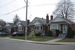
The "inner ring" suburbs of York and East York are older, predominantly middle-income areas, and ethnically diverse. Much of the housing stock in these areas consists of old pre-war single-family houses and post-war high-rises. Many of the neighbourhoods in these areas were built up as streetcar suburb
s and contain many dense and mixed-use streets. Mostly they share many characteristics with sections of the "old" city, outside of the downtown core.
The "outer ring" suburbs of Etobicoke, Scarborough, and North York are much more suburb
an in nature (although these boroughs are developing urban centres of their own, such as North York Centre
around Mel Lastman Square
). The following is a list of the more notable neighbourhoods, divided by the neighbourhoods' location based on the former municipalities, the names of which are still known and commonly used by Torontonians.
Toronto has many groups and associations to deal with neighbourhood issues, and larger umbrella organization
s organize events to deal with broader issues.
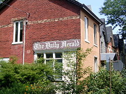 The Old Toronto refers to the City of Toronto and its boundaries from 1967 to 1997. It is sometimes referred to as the "South" or "Central" district, and includes the "downtown core". Some of these names such as "The Fashion District" are (or were) used as marketing for the areas or by BIAs; this area is actually called "King-Spadina" by locals. Another example is the "Old Town of York", known also as "King and Parliament".
Many were recreated or branded to reconnect the areas with their past history, early beginnings, or even recent use and prominence. Some historical city 'wards' used in the 19th century are no longer used: St. David's, St. John's, St. Paul's, St. George's, St. Andrew's, and St. Patrick's wards. There was a ward named for the patron saint of each of the three British nationalities: English (St. George), Scottish (St. Andrew), Welsh (St. David) and the Irish Saint: (St. Patrick). St. George, St. Andrew and St. Patrick still survive as subway stops, though St. George station is not named after the ward, but after St. George St., itself named after Quetton St. George, a local resident. St. Lawrence's Ward (named after patron saint of Canada and the river) remains, known today as "St. Lawrence").
For the purposes of geographic distinction, the neighbourhoods of Old Toronto are broken down into four subsections:
Downtown Core (Central)
East End
East York
East York, located north of Danforth Avenue between the Don River and Victoria Park Avenue, developed contemporaneously with the West End of the old City of Toronto, and is similar in form and character. It is currently administered as part of old Toronto. However, until 1997, it was an autonomous urban borough.
Scarborough
York

. The colours indicate the former municipality:
newspaper. Based on feedback from Star readers, it has produced the most comprehensive, albeit informal, neighbourhood map.
MLS
After the update of Toronto Multiple listing service (MLS)
on July 5, 2011, the Toronto Real Estate Board (TREB)
introduced a new searching mechanism for the Toronto MLS, used by real estate agents
operating in the region. MLS searches can now be refined at three levels and MLS users can search houses by area, then by municipality
, and then by neighbourhood or community. This was the first change of this magnitude in about 50 years of Toronto MLS history.
The change was designed to eliminate the obsolete coding systems whereby Greater Toronto
was divided into 86 artificial districts denominated by alphanumeric
codes. Due to the growing population in the city and the increasing difficulty of browsing the code-based system, the TREB made a radical change which is intended to simplify the use of MLS for real estate agents as well as home buyers.
Because Toronto is an enormous municipality of its own, the core city area will continue to be split into coded districts, although each of the districts will in turn contain neighbourhoods. Hence, the City will be easily searchable as well.
The following table contains a complete list of Toronto districts with a possibly incomplete list of Toronto neighbourhoods within each district:
Toronto
Toronto is the provincial capital of Ontario and the largest city in Canada. It is located in Southern Ontario on the northwestern shore of Lake Ontario. A relatively modern city, Toronto's history dates back to the late-18th century, when its land was first purchased by the British monarchy from...
, in Ontario
Ontario
Ontario is a province of Canada, located in east-central Canada. It is Canada's most populous province and second largest in total area. It is home to the nation's most populous city, Toronto, and the nation's capital, Ottawa....
, Canada
Canada
Canada is a North American country consisting of ten provinces and three territories. Located in the northern part of the continent, it extends from the Atlantic Ocean in the east to the Pacific Ocean in the west, and northward into the Arctic Ocean...
, is called "the city of neighbourhoods" because of the strength and vitality of its many communities. The city has upwards of 240 distinct neighbourhoods within its boundaries. Before 1998, Toronto was a much smaller municipality and formed part of Metropolitan Toronto
Metropolitan Toronto
The Municipality of Metropolitan Toronto was a senior level of municipal government in the Toronto, Ontario, Canada area from 1954 to 1998. It was created out of York County and was a precursor to the later concept of a regional municipality, being formed of smaller municipalities but having more...
. When the city amalgamated that year, Toronto grew to encompass the former municipalities of York
York, Ontario
York is a dissolved municipality in Toronto, Ontario, Canada. Geographically, it is located northwest of Old Toronto, southwest of North York and east of Etobicoke, where it is bounded by the Humber River. Formerly a separate city, it was one of six municipalities that amalgamated in 1998 to form...
, East York
East York
East York can refer to:*East York, Pennsylvania, United States*East York, Ontario, Canada...
, North York, Etobicoke, and Scarborough
Scarborough, Ontario
Scarborough is a dissolved municipality within the city of Toronto, Ontario, Canada. Geographically, it comprises the eastern part of Toronto. It is bordered on the south by Lake Ontario, on the west by Victoria Park Avenue, on the north by Steeles Avenue East, and on the east by the Rouge River...
. Each of these former municipalities still maintains, to a certain degree, its own distinct identity, and the names of these municipalities are still used by their residents. The area known as Toronto before the amalgamation is sometimes called the "old" City of Toronto, "Toronto proper", the Central District or simply "Downtown".
The "former" City of Toronto is, by far, the most populous and dense part of the city. It is also the business and administrative centre of the city. The uniquely Torontonian bay-and-gable
Bay-and-gable
A bay-and-gable is a distinct architectural style of house that is ubiquitous in the older parts of Toronto, Canada. The most prominent feature is the large bay window that usually covers more than half of the front of the house, surmounted by a gable roof...
housing style is common throughout the former city.
The "inner ring" suburbs of York and East York are older, predominantly middle-income areas, and ethnically diverse. Much of the housing stock in these areas consists of old pre-war single-family houses and post-war high-rises. Many of the neighbourhoods in these areas were built up as streetcar suburb
Streetcar suburb
A streetcar suburb is a residential community whose growth and development was strongly shaped by the use of streetcar lines as a primary means of transportation. Early suburbs were served by horsecars, but by the late 19th century cable cars and electric streetcars, or trams, were used, allowing...
s and contain many dense and mixed-use streets. Mostly they share many characteristics with sections of the "old" city, outside of the downtown core.
The "outer ring" suburbs of Etobicoke, Scarborough, and North York are much more suburb
Suburb
The word suburb mostly refers to a residential area, either existing as part of a city or as a separate residential community within commuting distance of a city . Some suburbs have a degree of administrative autonomy, and most have lower population density than inner city neighborhoods...
an in nature (although these boroughs are developing urban centres of their own, such as North York Centre
North York Centre
North York Centre is a town centre in North York, Toronto, Ontario, Canada. Prior to the Amalgamation of Toronto in 1998, it was considered the central business district of the former city of North York...
around Mel Lastman Square
Mel Lastman Square
Mel Lastman Square is a public square at North York Civic Centre in the North York, Toronto, Ontario, Canada. It is named for former North York mayor Mel Lastman....
). The following is a list of the more notable neighbourhoods, divided by the neighbourhoods' location based on the former municipalities, the names of which are still known and commonly used by Torontonians.
Toronto has many groups and associations to deal with neighbourhood issues, and larger umbrella organization
Umbrella organization
An umbrella organization is an association of institutions, who work together formally to coordinate activities or pool resources. In business, political, or other environments, one group, the umbrella organization, provides resources and often an identity to the smaller organizations...
s organize events to deal with broader issues.
Old Toronto
Many were recreated or branded to reconnect the areas with their past history, early beginnings, or even recent use and prominence. Some historical city 'wards' used in the 19th century are no longer used: St. David's, St. John's, St. Paul's, St. George's, St. Andrew's, and St. Patrick's wards. There was a ward named for the patron saint of each of the three British nationalities: English (St. George), Scottish (St. Andrew), Welsh (St. David) and the Irish Saint: (St. Patrick). St. George, St. Andrew and St. Patrick still survive as subway stops, though St. George station is not named after the ward, but after St. George St., itself named after Quetton St. George, a local resident. St. Lawrence's Ward (named after patron saint of Canada and the river) remains, known today as "St. Lawrence").
For the purposes of geographic distinction, the neighbourhoods of Old Toronto are broken down into four subsections:
Downtown Core (Central)Downtown TorontoDowntown Toronto is the central business district of Toronto, Ontario, Canada. It is approximately bounded by Bloor Street to the north, Lake Ontario to the south, the Don River to the east, and Bathurst Street to the west...
- Alexandra Park
- The AnnexThe AnnexThe Annex is a neighbourhood in downtown Toronto, Ontario, Canada. The traditional boundaries of the neighbourhood are north to Dupont Street, south to Bloor Street, west to Bathurst Street and east to Avenue Road...
- Baldwin VillageBaldwin VillageBaldwin Village is a commercial enclave in Toronto, Ontario, Canada. It is located in the west of downtown Toronto, within the Grange Park neighbourhood, one block north of Dundas Street West, between Beverley and McCaul Streets...
- CabbagetownCabbagetown, TorontoCabbagetown is a neighbourhood located on the east side of downtown Toronto, Ontario, Canada. It comprises "the largest continuous area of preserved Victorian housing in all of North America", according to the Cabbagetown Preservation Association....
- CityPlaceCityPlace, TorontoCityPlace is the name given to a large section of former railway land in downtown Toronto, Ontario, Canada that has been redeveloped for multi-use purpose. The term has been more recently used for a large up-scale multi-tower condo development in the Harbourfront district. When completed, this area...
- ChinatownChinatown, TorontoChinatown is an ethnic enclave in Downtown Toronto, Ontario, Canada, with a high concentration of ethnic Chinese residents and businesses extending along Dundas Street West and Spadina Avenue. First developed in the late 19th century, it is now one of the largest Chinatowns in North America and...
- Church and WellesleyChurch and WellesleyChurch and Wellesley is an LGBT-oriented community located in Toronto, Ontario, Canada. It is roughly bounded by Gerrard Street to the south, Yonge Street to the west, Charles Street to the north, and Jarvis Street to the east, with the core commercial strip located along Church Street from...
- CorktownCorktown, TorontoCorktown is a residential neighbourhood in downtown Toronto, Ontario, Canada. It is just south of Regent Park and north of the Gardiner Expressway, between Berkeley Street to the west and the Don River to the east, Shuter Street to Lake Shore Boulevard East, this area also includes the Distillery...
- Discovery DistrictDiscovery DistrictThe Discovery District is an area of downtown Toronto, Ontario, Canada, that features a high concentration of hospitals and research institutions, particularly those related to biotechnology...
- Distillery District
- The Entertainment District
- East BayfrontEast BayfrontEast Bayfront, or the East Bayfront Precinct, is an emerging neighbourhood in Toronto, Ontario, Canada. It is currently undergoing a transformation from industrial use to mixed use....
- Fashion District
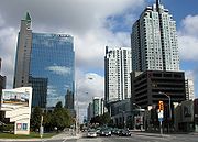
- The Financial DistrictFinancial District, TorontoThe Financial District is a business district in Toronto, Ontario, Canada, within the downtown core. It was originally planned as New Town in 1796 as an extension of the Town of York . It is the main financial district in Toronto, and is the financial heart of Canada...
- Garden District
- Grange ParkGrange Park (neighbourhood)Grange Park is a neighbourhood in downtown Toronto, Ontario, Canada. It is bounded on the west by Spadina Avenue, on the north by College Street, on the east by University Avenue and on the south by Queen Street. It is within the 'Kensington-Chinatown' City of Toronto planning neighbourhood. Its...
- Harbord Village
- HarbourfrontHarbourfrontHarbourfront is a neighbourhood on the northern shore of Lake Ontario within the downtown core of the city of Toronto, Canada. Part of the Toronto Waterfront, Harbourfront extends west from Yonge Street to Bathurst Street along Queen's Quay. East of Yonge to Parliament St...
- Kensington MarketKensington MarketKensington Market is a distinctive multicultural neighbourhood in Downtown Toronto, Ontario, Canada. The Market is an older neighbourhood and one of the city's most well-known. In November 2006, it was designated a National Historic Site of Canada. Robert Fulford wrote in 1999 that "Kensington...
- Moss Park
- Queen Street WestQueen Street WestQueen Street West describes both the western branch of Queen Street, a major east-west thoroughfare, and a series of neighbourhoods or commercial districts, situated west of Yonge Street in downtown Toronto, Ontario, Canada. Queen Street begins in the west at the intersection of King Street, The...
- Regent ParkRegent ParkRegent Park is a neighbourhood located in Old Toronto, Ontario, Canada. Regent Park is Canada's oldest and largest social housing project; built in the late 1940s. Formerly the centre of the Cabbagetown neighbourhood, it is bounded by Gerrard Street East to the north, River Street to the east,...
- St. James Town
- St. LawrenceSt. Lawrence, TorontoSt. Lawrence is a neighbourhood located in downtown Toronto, Ontario, Canada. The area, a former industrial area, is bounded by Yonge, Front, and Parliament Streets, and the Canadian National railway embankment. The Esplanade off Yonge St., lined with restaurants, cafés and hotels runs through the...
- Toronto IslandsToronto IslandsThe Toronto Islands are a chain of small islands in the city of Toronto, Ontario. Comprising the only group of islands in the western part of Lake Ontario, the Toronto Islands are located just offshore from the city centre, and provide shelter for Toronto Harbour...
- Trefann CourtTrefann CourtTrefann Court is a small neighbourhood in the eastern part of downtown Toronto, Canada. It is located on the north side of Queen Street between Parliament Street and River Street. It extends north only a short distance to Shuter St. In the nineteenth century Trefann Court was considered a part of...
- University of TorontoUniversity of TorontoThe University of Toronto is a public research university in Toronto, Ontario, Canada, situated on the grounds that surround Queen's Park. It was founded by royal charter in 1827 as King's College, the first institution of higher learning in Upper Canada...
St. George Campus - YorkvilleYorkville, TorontoYorkville is a district in Toronto, Ontario, Canada, well known for its shopping. It is a former village, annexed by the City of Toronto. It is roughly bounded by Bloor Street to the south, Davenport Road to the north, Yonge Street to the east and Avenue Road to the west, and is considered part of...
East EndEast TorontoEast Toronto, Ontario was an incorporated community in what is today a part of the city of Toronto, Canada. It covered much of what is today the Upper Beaches neighbourhood, stretching up to Danforth Avenue in the north. The central street in the community was Main Street, running south from...
- The BeachesThe BeachesThe Beaches is a neighbourhood and popular tourist destination located in Toronto, Ontario, Canada. It is located on the east side of the "Old" City of Toronto. The original boundaries of the neighbourhood are from Fallingbrook Avenue on the east to Kingston Road on the north, to Woodbine Avenue...
(also known as The Beach) - East DanforthEast DanforthEast Danforth is a neighbourhood in Toronto, Canada. It is located on the eastern part of Danforth Avenue in the old city of Toronto. It stretches from the eastern edge of Greektown by Jones Avenue to the boundary of Scarborough at Victoria Park Avenue. The area is covered by two business...
- Gerrard Street East (Little India)
- Greektown
- LeslievilleLeslievilleLeslieville is a neighbourhood in Toronto, Ontario, Canada east of the Don River bounded by the Canadian National railway line and Gerrard Street to the north, Empire Avenue to the west, Eastern Avenue to south, and Coxwell Avenue to the east.-History:...
- Main SquareMain SquareMain Square is a complex of four apartment buildings in Toronto, Canada. The three-hectare site houses about 2000 people. It is located in the eastern part of the city at the intersection of Main Street and Danforth Avenue. The complex is located just north of the railway lines and the Danforth GO...
- Playter EstatesPlayter EstatesPlayter Estates is an area in the east end of Toronto, Canada bounded by Jackman Avenue to the east, the Don River Valley to the west, Danforth Avenue in the south, and Fulton Avenue in the north. The neighbourhood is built on land once owned by the Playter family for whom two streets in the area...
- Port LandsPort LandsThe Port Lands of Toronto, Ontario, Canada are an industrial and recreational neighbourhood located about 5 kilometres south-east of downtown, located on the former Don River delta and most of Ashbridge's Bay....
- RiverdaleRiverdale, TorontoRiverdale is a large neighbourhood in Toronto, Ontario, Canada. It is bounded by the Don River Valley to the west, Danforth Avenue and Greektown to the north, Jones Avenue, the CN/GO tracks, and Leslieville to the east, and Lake Shore Boulevard to the south....
- Upper BeachesUpper BeachesThe Upper Beaches is a rather recently coined name for the neighbourhood directly north of the Beaches area in Toronto, Ontario, Canada. It stretches from Coxwell Avenue in the west to Victoria Park in the east. The southern border is Kingston Road, while the northern boundary is generally...
North End
- Bedford ParkBedford Park, TorontoBedford Park began as a farming hamlet north of Toronto. The hamlet was a popular stopover for farmers making their way to market in the city. The neighbourhood was likely named after the Bedford Park Hotel, which opened in 1873 at the southwest corner of Yonge Street and Fairlawn Avenue, just...
- Casa Loma
- Chaplin Estates
- Davisville Village
- Deer ParkDeer Park, TorontoDeer Park is a neighbourhood in Toronto, Ontario, Canada, centred on the intersection of Yonge Street and St. Clair Avenue; its boundaries are the Vale of Avoca section of Rosedale ravine in the east, Farnham Avenue and Jackes Avenue in the south, Avenue Road and Oriole Parkway in the west, the...
(Yonge and St. Clair) - Forest HillForest Hill, TorontoForest Hill is an affluent neighbourhood in central Toronto, Ontario, Canada. Along with Lawrence Park, Rosedale, and The Bridle Path, it is one of Toronto’s wealthiest neighbourhoods.-History:...
(and Forest Hill Village) - Lawrence ParkLawrence Park, TorontoLawrence Park is one of Toronto, Canada's most affluent residential neighbourhoods, along with Rosedale, the Bridle Path, and Forest Hill. It is also one of the wealthiest neighbourhoods in Canada....
- Lytton Park
- MidtownMidtown, TorontoMidtown Toronto is an area of Toronto, Ontario, Canada roughly defined as the area north of Bloor Street and south of Lawrence Avenue, The east and west borders are somewhat defined as Bayview Avenue to Marlee Avenue/Oakwood Avenue/Ossington Avenue. The centre of this area is Yonge and Eglinton...
- Moore ParkMoore Park, TorontoMoore Park is a neighbourhood in Toronto, Ontario, Canada. It lies along both sides of St. Clair Avenue East between the Vale of Avoca section of Rosedale ravine and Moore Park ravine . The northern boundary is Mount Pleasant Cemetery and the southern the Canadian Pacific Railway tracks.The...
- North TorontoNorth TorontoNorth Toronto was a town located in the northern part of the Old Toronto district in Toronto, Ontario, Canada. It occupies a geographically central location within the current boundaries of the city of Toronto. It is a relatively narrow strip, centred around Yonge Street; it extends from the CP...
- RosedaleRosedale, TorontoRosedale is an affluent neighbourhood in Toronto, Ontario, Canada, which was formerly the estate of William Botsford Jarvis, and so named by his wife, granddaughter of William Dummer Powell, for the wild roses that grew there in abundance....
- South HillSouth Hill, TorontoSouth Hill is an area of Toronto, Ontario, Canada. It is located north of downtown covering the area west of Avenue Road, south of St. Clair Avenue, east of Spadina Road, and north of the Canadian Pacific railway tracks. The area is dominated by the steep hill of the former Lake Iroquois shoreline...
(includes Rathnelly) - SummerhillSummerhill, TorontoThe Summerhill neighbourhood in central Toronto was named after 'Summer Hill' house, built in 1842 by Canadian transportation baron Charles Thompson.Much of the area was once part of the Thompson estate but was subdivided by his heirs in the 1880s....
- Wanless ParkWanless ParkWanless Park is a neighbourhood and park in North Toronto. It is located just north of Lawrence Avenue, between Bayview Avenue and Yonge Street.Central to the Wanless Park neighbourhood is a public park called Wanless Park...
- Wychwood ParkWychwood ParkWychwood Park is a neighbourhood enclave and former gated community in Toronto, Canada. The small community is located north of Davenport Road and just west of Bathurst Street. It was founded as an artists colony in the late nineteenth century as a private project by painter Marmaduke Matthews...
- Yonge and EglintonYonge and EglintonYonge and Eglinton, also known as Yonge-Eglinton or Uptown, is a neighbourhood in Midtown-Toronto, Ontario, Canada, which was once a part of the old Town of North Toronto....
(considered centre of Midtown Toronto)
West End
- Bloor West VillageBloor West VillageBloor West Village is a shopping district in Toronto, Ontario, Canada. Located along Bloor Street, it encompasses all businesses along Bloor Street between Jane Street and Ellis Park Road, consisting of more than 400 shops, restaurants and services. The mix of stores include specialty clothing...
- Bracondale HillBracondale HillBracondale Hill, also known as Hillcrest, is a neighbourhood located in Toronto, Ontario, Canada. Annexed by the old City of Toronto in 1909 and developed in 1911 from the Turner estate, Bracondale Hill is in the western end of midtown Toronto and stretches above Davenport Road and below St. Clair...
- Brockton VillageBrockton VillageBrockton Village is a neighbourhood in Toronto, Ontario, Canada. It comprises a section of the old Town of Brockton which was annexed by the City of Toronto in 1884. The town encompassed the area from Bloor Street on the north, Dufferin Street on the east, High Park on the west and ranged from...
- Carleton VillageCarleton villageCarleton used to be a separate village or small hamlet one mile east of the centre of Penrith, Cumbria, England. Today, it is a rural suburb in an area of Penrith that has seen the most growth of housing in the past 30 years.- Name origin :...
- Corso Italia
- Davenport
- Dovercourt Park
- Dufferin GroveDufferin GroveDufferin Grove is a neighbourhood located in Toronto, Ontario, Canada, west of downtown. The neighbourhood is bordered by Bloor Street West to the north, Ossington Ave to the east, College Street to the south, and Dufferin Street to the west.-Character:...
- Earlscourt
- Fort YorkFort York (neighbourhood)The Fort York neighbourhood, also known as Garrison, in Toronto, Ontario, Canada is located along and south of CN and CP railway corridors...
- High ParkHigh Park NorthHigh Park North, or often, simply 'High Park', after the park, is a neighbourhood in Toronto, Ontario, Canada. It is bounded on the south by Bloor Street, on the west by Runnymede Road, on the north by Annette Street, Quebec Avenue and Humberside Avenue, and on the east by the CNR/CPR railway...
- The JunctionThe JunctionThe Junction is a neighbourhood in Toronto, Ontario, Canada, that is near the junction of four railway lines in the area known as the West Toronto Diamond. The neighbourhood was previously an independent city called West Toronto, that was also its own federal electoral district until amalgamating...
(formerly West Toronto) - Junction TriangleJunction TriangleJunction Triangle is a neighbourhood in Toronto, Canada. It is located in the city's west end, just west of Lansdowne Avenue. The area is a triangle surrounded on all three sides by railway lines. The CNR/CPR mainline to the west, the CNR railway lines to the east, and the CPR east-west railway...
- KoreatownKoreatown, TorontoToronto, Ontario, Canada's Korean Business Area, known more generally as Koreatown , is composed of the retail businesses along Bloor Street between Christie and Bathurst Streets in the Seaton Village section of The Annex...
- Liberty VillageLiberty VillageLiberty Village is a neighbourhood in Toronto, Ontario, Canada. It is bounded at the north by King Street West, the west by Dufferin Street, the south by the Gardiner Expressway, the east by Strachan Avenue, and the northeast by the CP railway tracks...
- Little ItalyLittle Italy, TorontoLittle Italy, sometimes referred to as College Street West, is a district in Toronto, Ontario, Canada. It is well known for its numerous Italian Canadian restaurants and businesses. There is also a significant Latin American and Portuguese community in the area...
- Little PortugalLittle Portugal, TorontoLittle Portugal is a neighbourhood and ethnic enclave in Toronto, Ontario, Canada. It is located west of downtown in the "Old" City of Toronto. It is bounded on the west by Lansdowne Avenue, on the north by College Street, on the east by Ossington Avenue and on the south by the CNR/CPR mainline...
- Malta Village
- Mirvish Village
- Niagara
- PalmerstonPalmerston-Little ItalyPalmerston–Little Italy is a neighbourhood in central Toronto, Ontario, Canada. Its boundaries, according to the City of Toronto, are by Bathurst Street to the east, Bloor Street to the north, Dovercourt Road to the west and College Street to the south. It is a mature downtown neighbourhood...
- ParkdaleParkdale, TorontoParkdale is a neighbourhood and former village in Toronto, Ontario, Canada, west of downtown. The neighbourhood is bounded on the west by Roncesvalles Avenue, on the north by Queen Street. It is bounded on the east by Dufferin Street from Queen Street south, and on the south by Lake Ontario...
- Pelham Park
- Roncesvalles
- RunnymedeRunnymede, TorontoRunnymede is a neighbourhood in Toronto, Ontario, Canada located north of Bloor Street West between Jane Street and Runnymede Road north to Dundas Street West. It is located directly north of the former village of Swansea and west of the High Park North neighbourhood...
- Seaton VillageSeaton VillageSeaton Village is a former unincorporated village located west of downtown Toronto, Ontario, Canada. It is named after John Colborne, 1st Baron Seaton, Lieutenant-Governor of Upper Canada from 1828 to 1836. Seaton Village is bordered by Bloor Street to the south, the train tracks to the north,...
- SwanseaSwansea, TorontoSwansea is a neighbourhood in the City of Toronto, Ontario, Canada, bounded on the west by the Humber River, on the north by Bloor Street, on the east by High Park and on the south by Lake Ontario...
- Trinity-Bellwoods (Portugal Village)
East YorkEast YorkEast York can refer to:*East York, Pennsylvania, United States*East York, Ontario, Canada...
East York, located north of Danforth Avenue between the Don River and Victoria Park Avenue, developed contemporaneously with the West End of the old City of Toronto, and is similar in form and character. It is currently administered as part of old Toronto. However, until 1997, it was an autonomous urban borough.- BermondseyBermondsey, TorontoBermondsey is an industrial area in Toronto, Canada. It covers a rough triangle with the Don Valley to the west, Eglinton Avenue to the northeast and O'Connor Drive to the southeast. It straddles the border of the former cities of North York and East York...
- Broadview NorthOld East YorkOld East York is a neighbourhood in the city of Toronto located in the former East York. While East York was a much larger area, the name has been kept as a reminder to the days before the mega city. There are multiple definitions of its extent, but at its largest Old East York has covers the...
- Crescent Town
- East DanforthEast DanforthEast Danforth is a neighbourhood in Toronto, Canada. It is located on the eastern part of Danforth Avenue in the old city of Toronto. It stretches from the eastern edge of Greektown by Jones Avenue to the boundary of Scarborough at Victoria Park Avenue. The area is covered by two business...
- Governor's Bridge
- LeasideLeasideLeaside is a neighbourhood in Toronto, Ontario, Canada. The area takes its name from William Lea and the Lea family, who settled there in the early years of the nineteenth century. The area first developed as farmland along with Toronto through the nineteenth century. It was incorporated as a...
- O'Connor–Parkview
- Pape VillagePape VillagePape Village is a commercial district in Toronto, Canada, located within the neighbourhood of Old East York. It is a mixed-use shopping street, consisting mainly of small-scale retail, restaurant and personal service uses.-Location:...
- Thorncliffe ParkThorncliffe ParkThorncliffe Park is a densely populated, multicultural neighbourhood in central east Toronto, Ontario, Canada, in the former Borough of East York. East York merged with five other municipalities and a regional government in 1998 to form the new "City of Toronto"...
- Woodbine Heights
- Woodbine-LumsdenOld East YorkOld East York is a neighbourhood in the city of Toronto located in the former East York. While East York was a much larger area, the name has been kept as a reminder to the days before the mega city. There are multiple definitions of its extent, but at its largest Old East York has covers the...
Etobicoke
- AlderwoodAlderwood, TorontoAlderwood is a neighbourhood in the city of Toronto, Ontario, Canada. It is in the western section of Toronto, formerly the city of Etobicoke. It is bounded by the Etobicoke Creek to the west, the Gardiner Expressway to the north, the CPR railway to the east and the CNR railway to the...
- Centennial Park
- Clairville
- EatonvilleEatonville, TorontoEatonville is a neighbourhood in the Etobicoke community of the city of Toronto, Ontario, Canada. Located west of the area known as Islington, Eatonville is bisected by Highway 427, with the community generally located north of Dundas Street West and south of Rathburn Road...
(Etobicoke West Mall) - The Elms
- Eringate
- Humber Heights-WestmountHumber Heights-WestmountHumber Heights-Westmount, also known as Humbervale, is a neighbourhood in Etobicoke, Toronto, Ontario. The neighbourhood is bounded by the west bank of the Humber River, west to Royal York Road and south to Eglinton Avenue West...
- Humber Valley Village
- HumberwoodHumberwoodHumberwood is a small neighbourhood in Rexdale, Etobicoke, Toronto, Canada. Humberwood is named after the Humber River, which flows along the eastern edge of Etobicoke.-Boundaries:...
- Islington-City Centre West
- Kingsview Village (The Westway)
- The KingswayThe KingswayThe Kingsway, known also as Kingsway South, is a residential neighbourhood of Toronto, Ontario, Canada. It is located in the former City of Etobicoke, an area that became the west end of Toronto upon amalgamation in 1998. It is bounded by Bloor Street to the south, Dundas Street to the north, the...
- Long BranchLong Branch, TorontoThe former Village of Long Branch is a neighbourhood in the south-west of Toronto, Ontario, Canada. It is located in the south-west corner of the former Township of Etobicoke and was a partially-independent municipality from 1930-1967...
- Markland WoodMarkland WoodMarkland Wood is a residential neighbourhood located in Etobicoke, in the City of Toronto, Ontario, Canada. It is bounded by Etobicoke Creek to the west, Elmcrest Creek to the east and surrounded by the Markland Wood Country Club...
- MimicoMimicoThe historic Town of Mimico is a neighbourhood in the south-western part of Toronto, Ontario, Canada. It is located in the south-east corner of the former Township of Etobicoke, and was an independent municipality from 1911 to 1967....
- New TorontoNew TorontoThe historic Town of New Toronto is a neighbourhood in the south-west end of Toronto, Ontario, Canada. It is located in the south-centre of the former Township of Etobicoke and was an independent municipality from 1913 to 1967, one of the former 'Lakeshore Municipalities'...
- Princess GardensPrincess GardensPrincess Gardens is a neighbourhood in Toronto, Ontario, Canada. It is located in the western area of Toronto that was formerly the City of Etobicoke. Its boundaries are Eglinton Avenue to the north, Martin Grove to the west, Islington to the east, and Rathburn Road to the south. The southeastern...
- RexdaleRexdaleRexdale is a neighbourhood located in the north-west corner of Toronto, Ontario, Canada. It covers the northern section of Etobicoke, which was an independent city until it merged with five other municipalities and a regional government to form the new City of Toronto in 1998. Rexdale was named...
- RichviewRichview, TorontoRichview is a neighbourhood in the city of Toronto, Ontario, Canada. It is located in the former city of Etobicoke. It is bounded on the west by Highway 401 and on the north by the highway and by Dixon Road, Royal York Road on the east, and Eglinton Avenue West along the south...
- SmithfieldSmithfield, TorontoSmithfield is part of the Rexdale neighbourhood in the northwestern area of Etobicoke, in the City of Toronto, Ontario, Canada. Some new residents to Toronto and new immigrants to Canada are attracted to this neighbourhood, mainly because there is a large amount of affordable public housing...
- Stonegate-Queensway
- Sunnylea
- ThistletownThistletownThistletown is a culturally diverse neighbourhood in Toronto, Ontario, Canada. Thistletown is also a part of the Rexdale community in the northern part of Etobicoke. It consists of the area surrounding the intersection of Albion Road and Islington Avenue in the former City of Etobicoke...
- Thorncrest VillageThorncrest VillageThorncrest Village is a neighbourhood in northwestern Toronto. It is a collection of tree-lined streets north of Rathburn Road, between Kipling and Islington avenues, in what used to be part of Etobicoke....
- West Humber-ClairvilleWest Humber-ClairvilleClairville is the northwestern most neighbourhood in the city of Toronto, Ontario, Canada. The neighbourhood is part of Rexdale, in north Etobicoke. Today Clairville is almost wholly industrial/commercial.-History:...
- West Deane Park
- Willowridge
ScarboroughScarborough, OntarioScarborough is a dissolved municipality within the city of Toronto, Ontario, Canada. Geographically, it comprises the eastern part of Toronto. It is bordered on the south by Lake Ontario, on the west by Victoria Park Avenue, on the north by Steeles Avenue East, and on the east by the Rouge River...
- AgincourtAgincourt, TorontoAgincourt is a very diverse neighbourhood in the Scarborough district of the city of Toronto, Ontario, Canada. It is centred along Sheppard Avenue between Kennedy and Markham Roads...
- ArmadaleArmadale, OntarioArmadale is the name of a community that overlaps into the Town of Markham and the former city of Scarborough in Toronto, Ontario, Canada. The historical community is situated in the south-east of Markham and north-east of Scarborough.-History:...
- BendaleBendaleBendale, also called Cedarbrae, is a neighbourhood in the eastern part of Toronto, Ontario, Canada, in Scarborough. The area is ethnically diverse, like much of Toronto, but has a greater proportion of South Asian population, especially Tamils....
(Cedarbrae) - Birch CliffBirch CliffBirch Cliff is a neighbourhood in Toronto, Canada. It is located in the southwest part of the old city of Scarborough running along shore of Lake Ontario atop the eastern part of the Scarborough Bluffs. The area was first developed as the home of the Toronto Hunt Club in 1895 when the region was...
- Bridlewood
- Brown's CornersBrown's Corners, TorontoBrown's Corners is the name of a community in Scarborough in Toronto, Ontario, Canada at the corner of Finch Avenue East and Markham Road.David Brown operated a business and post office on the southwest corner. The Post Office was relocated to Malvern Village, but the business continued as a...
(historical) - Clairlea
- Cliffside
- CliffcrestCliffcrestCliffcrest is a neighborhood in the city of Toronto, Ontario, Canada, located in the district of Scarborough. The neighborhood runs along Lake Ontario to the south and is bordered by Midland Ave. to the west, the Canadian National Railway to the north, and Bellamy Rd. to the east...
- Dorset ParkDorset ParkDorset Park is a neighbourhood in Scarborough, a district of the city of Toronto, Ontario, Canada. The neighbourhood is located in western Scarborough, bordered by Highway 401 to the North, Midland Avenue to the East, Lawrence Avenue to the South, Birchmount Road to the west, and Kennedy Road...
- Eglinton East
- Golden Mile
- GuildwoodGuildwoodGuildwood, also known as Guildwood Village, is a historic and residential neighbourhood in Scarborough, Toronto, Ontario, Canada. It is located along the Scarborough Bluffs, south of Kingston Road, from Grey Abbey Trail in the east to the end of Sylvan Avenue in the west.-History:Guildwood village...
- Highland CreekHighland Creek, TorontoHighland Creek is a neighbourhood in south-east Scarborough in Toronto, Ontario, Canada that lies along the southern portion of the river of the same name...
- Hillside
- IonviewIonviewIonview is a neighbourhood in Toronto, Ontario, in the district of Scarborough. It is bounded by Birchmount Road to the west, the hydro transmission corridor north of Ranstone Gardens to the north, the CNR railway to the east, and Eglinton Avenue East, Kennedy Road and the CNR railway to the south...
- L'AmoreauxL'AmoreauxL'Amoreaux is a neighbourhood in Toronto, Ontario, Canada, situated east of Victoria Park Avenue, south of McNicoll Avenue, west of Kennedy Road and north of Huntingwood Drive. L'Amoreaux is named after Josue L'Amoreaux , a French Huguenot loyalist who settled in the area...
- MalvernMalvern, TorontoMalvern is a neighbourhood in Toronto, Ontario, Canada, with a population of 44,315. It is located in the northeast corner of the city, in the district of Scarborough. Scarborough was merged with five other municipalities and a regional government to form the new City of Toronto in 1998...
- MaryvaleMaryvale, TorontoMaryvale is a neighbourhood in the Scarborough section of Toronto, Canada. It is located on the edge of Scarborough with its western border being Victoria Park Avenue...
- MillikenMilliken, OntarioMilliken or Milliken Mills is a neighbourhood in the city of Toronto and Markham, Ontario. It is located in the North East section of Scarborough and South East section of Markham...
- Morningside HeightsMorningside Heights, TorontoMorningside Heights is a neighbourhood in Scarborough, within the city of Toronto, Ontario, Canada. It is located in the northeast corner of the city, just north of the Malvern community and west of Rouge Park...
- Morningside
- Oakridge
- Orton Park
- Port UnionPort Union, OntarioPort Union, also known as Centennial Scarborough is a neighbourhood located in Scarborough, part of Toronto, Ontario, Canada. The neighbourhood is bounded by Kingston Road to the north, Port Union Road to the east, the Lake Ontario shoreline to the south, and Highland Creek to the west.The...
(Centennial Scarborough) - Rouge
- Scarborough City CentreScarborough City CentreScarborough City Centre is the central business district in the Scarborough district of Toronto, Ontario, Canada. It is roughly bounded by Kennedy Road to the west, Markham Road to the east, Ellesmere Road to the south, and Sheppard Avenue to the North...
- Scarborough Junction
- Scarborough VillageScarborough VillageScarborough Village is a neighbourhood in Toronto, Ontario, Canada, in the south-central part of the district of Scarborough. Historically, it was one of the earliest settlements in the former Township of Scarborough and was the first region of the township to have its own post office...
- Steeles
- Tam O'Shanter-SullivanTam O'Shanter-SullivanTam O'Shanter–Sullivan is a neighbourhood in the east end of the city of Toronto, in the district of Scarborough. The neighbourhood is bordered by Huntingwood Drive to the North, Kennedy Road to the East, Highway 401 to the South and Victoria Park to the West...
- West HillWest Hill, Toronto-Location and principal features:It is located in the eastern end of the city, in the former city of Scarborough. Scarborough was merged with five other municipalities and a regional government to form the new "City of Toronto" in 1998...
- West RougeWest RougeWest Rouge is a small community neighbourhood located in the city of Toronto, Ontario, Canada, within the district of Scarborough. The community is roughly bounded by Lake Ontario to the south, the Rouge River to the east, Highland Creek to the west and Kingston Road to the north.The area was...
- WexfordWexford, TorontoWexford is a neighbourhood in Toronto, Ontario, Canada. It is located in the eastern part of the city, on the western end of the district of Scarborough, spanning Lawrence Avenue East between Victoria Park Avenue and Birchmount Road. There are many Greeks in this neighbourhood.The Church of St...
- Wishing Well Acres
- WoburnWoburn, TorontoWoburn, also known as Cedarbrae, is a neighbourhood located in Toronto, Ontario, Canada, in the district of Scarborough.-Geography:Woburn is bordered by Highway 401 to the north, Scarborough Golf Club Road and Orton Park Road to the east, the CN Railway tracks to the south, and McCowan Road and...
North York
- AmesburyAmesbury, TorontoAmesbury is a neighbourhood in Toronto, Ontario, Canada, formerly in North York before it was amalgamated into Toronto in 1998. It is part of federal and provincial electoral district York South—Weston, and Toronto electoral wards 11: York South—Weston and 12: York South-Weston .Its borders are...
- Armour Heights
- Bathurst ManorBathurst ManorBathurst Manor is a neighbourhood located in the North York district of Toronto, Ontario, Canada. It sits on a plateau bounded on the north by Finch Avenue West, on the west by Dufferin Street, on the east by the Don River , and on the south by Sheppard Avenue West. The area is also regarded as...
- Bayview VillageBayview VillageBayview Village is an affluent neighbourhood in Toronto, Ontario, Canada, formerly in North York before it was amalgamated into Toronto in 1998. It is part of the federal and provincial electoral district Willowdale, and Toronto electoral wards 24: Willowdale and 33: Don Valley North...
- Bayview Woods – Steeles
- BermondseyBermondsey, TorontoBermondsey is an industrial area in Toronto, Canada. It covers a rough triangle with the Don Valley to the west, Eglinton Avenue to the northeast and O'Connor Drive to the southeast. It straddles the border of the former cities of North York and East York...
- Black Creek
- The Bridle PathBridle Path, TorontoThe Bridle Path upscale residential neighbourhood in the former city of North York, now part of Toronto, Ontario, Canada, that is characterized by large multi-million dollar mansions and two to four acre lot sizes. It is often referred to as "Millionaires' Row"...
- Clanton ParkClanton ParkClanton Park, sometimes referred to as Dublin Heights or Wilson Heights, is a neighbourhood in the North York area of Toronto, Ontario, Canada. It is part of federal and provincial electoral district York Centre, and Toronto electoral wards 9: York Centre and 10: York Centre...
(Wilson Heights) - Don MillsDon MillsDon Mills is a mixed-use neighbourhood in the North York district of Toronto, Canada. It was developed to be a self-supporting "new town" and was at the time located outside of Toronto proper. Consisting of residential, commercial and industrial sub-districts, it was planned and developed by...
- Don Valley VillageDon Valley VillageDon Valley Village is a neighbourhood in the city of Toronto, Ontario, Canada. It is located north of Highway 401, and is bounded by Sheppard Avenue to the south, Leslie Street to the west, Finch Avenue to the north and Highway 404 to the east...
- Downsview
- Emery
- Flemingdon ParkFlemingdon ParkFlemingdon Park is a multicultural community in Toronto, Ontario, Canada, located in the North York district of the city. It is part of federal and provincial electoral district Don Valley West, and Toronto electoral ward 26: Don Valley West...
- Glen ParkGlen Park, TorontoGlen Park is a neighbourhood in the city of Toronto, Ontario, Canada, located in the district of North York. It is bounded by Lawrence Avenue to the north, Bathurst Street to the east, a line south of Stayner Avenue to the south, and the CNR tracks to the west. Prior to the amalgamation of...
- Henry FarmHenry FarmHenry Farm is an officially designated neighbourhood in the City of Toronto, Ontario, Canada. It is located in the north central part of town within the district of North York....
- Hillcrest VillageHillcrest VillageHillcrest Village is a neighbourhood located in the district of North York at the northernmost tip of the city of Toronto, Ontario, Canada. Hillcrest Village is considered by some to be part of the Don Valley Village, the neighbourhood directly to the south, however it is quite distinct...
- Hoggs Hollow
- Humber SummitHumber SummitHumber Summit is one of the northernmost neighbourhoods in Toronto, Ontario, located in the North York district of the city. It is bounded by Steeles Avenue to the north, Highway 400 to the east, Finch Avenue to the south, and follows the Humber River to the west.-Character:In the 1840s, Humber...
- HumbermedeHumbermedeHumbermede, often called Emery, is a neighbourhood of Toronto, Ontario, Canada. Humbermede, like many of the "Humber" neighbourhoods in the city, gets its name from the Humber River...
(also known as Emery) - Jane and FinchJane and FinchJane and Finch is a neighbourhood located in northwestern North York, a district of Toronto, Ontario, Canada. The area is roughly bounded by Highway 400 to the west, Driftwood Avenue to the east, Grandravine Drive to the south, and Shoreham Drive to the north...
(University Heights; Elia) - Lansing
- Lawrence HeightsLawrence HeightsLawrence Heights is a neighbourhood in Toronto, Ontario, Canada. It is located north-west of central Toronto, in the district of North York. The neighbourhood is bounded by Lawrence Avenue to the south, Highway 401 to the north, Allen Road to the east and Dufferin Street to the west...
- Ledbury Park
- Lawrence ManorLawrence ManorLawrence Manor is a neighbourhood in the city of Toronto, Ontario, Canada. The neighbourhood is bounded by Bathurst Street on the east, Highway 401 to the north, the Allen to the west, and Lawrence Avenue to the south...
- Maple LeafMaple Leaf, TorontoMaple Leaf is a neighbourhood in the city of Toronto, Ontario, Canada. It is located in the southwest of the North York district. Its approximate borders are Lawrence Avenue to the south, Jane Street to the west, Highway 401 to the north, The CNR rail lines east of Keele Street to the...
- Newtonbrook
- North York CentreNorth York CentreNorth York Centre is a town centre in North York, Toronto, Ontario, Canada. Prior to the Amalgamation of Toronto in 1998, it was considered the central business district of the former city of North York...
- Parkway ForestParkway ForestParkway Forest is a neighbourhood in Toronto, Ontario, Canada. It is located in the north of the city, in the former City of North York. North York was merged with five other municipalities and a regional government to form the new "City of Toronto" in 1998....
- Parkwoods
- The Peanut
- Pelmo Park-HumberleaPelmo Park-HumberleaPelmo Park-Humberlea is a neighbourhood of in the North York area of Toronto, Ontario, Canada. Like its name implies, it is composed of two geographic areas, the first being the Pelmo Park area which is bordered by the 401 to the north, Woodward Avenue to the south, Jane Street to the east and the...
- Pleasant View
- Uptown TorontoUptown TorontoUptown Toronto has traditionally been a name given to the area north of Downtown Toronto. As the portion of the city that could be considered to be downtown or midtown has grown, the region has pushed further north....
- Victoria Park Village
- Westminster-BransonWestminster-BransonWestminster and Branson are two neighbourhoods in the city of Toronto, Ontario, Canada. They are in the northernmost part of the city within the area of North York....
- WillowdaleWillowdale, TorontoWillowdale is an established, affluent community in the city of Toronto, Ontario, Canada, located in the district of North York. It was originally called Lansing, which is now the name of a nearby neighbourhood....
- York MillsYork MillsYork Mills is the name of an affluent neighbourhood around Yonge Street and York Mills Road located in the district of North York in the city of Toronto, Ontario, Canada....
- York University HeightsYork University HeightsYork University Heights, also known as Northwood Park, is one of the northernmost neighbourhoods in the city of Toronto, Ontario. The name of the neighbourhood is because it contains the main campus of York University. This area is most popular with immigrants of Italian and Chinese descent who...
(Village at York)
YorkYork, OntarioYork is a dissolved municipality in Toronto, Ontario, Canada. Geographically, it is located northwest of Old Toronto, southwest of North York and east of Etobicoke, where it is bounded by the Humber River. Formerly a separate city, it was one of six municipalities that amalgamated in 1998 to form...
- Baby PointBaby PointBaby Point is a residential neighbourhood in west end of Toronto, Ontario, Canada. It was formerly in the City of York, and was two independent municipalities prior to that. It is bounded on the west by the Humber River from south of Baby Point Crescent to St. Marks Road, east to Jane Street and...
- Eglinton WestEglinton WestEglinton West, also known as Little Jamaica, is a neighbourhood and retail district of Toronto, Ontario, Canada situated along Eglinton Avenue West from Allen Road to Keele Street, in the former borough of York. There are a large number of Jamaican businesses along this strip. There are also...
- FairbankFairbank, TorontoFairbank is a neighbourhood located in the city of Toronto. It covers a large central portion of the former city of York, Ontario centered on the intersection of Dufferin Street and Eglinton Avenue. The western border is the CNR lines...
(Briar Hill-Belgravia) - Humewood–Cedarvale
- LambtonLambton, TorontoLambton is a neighbourhood in the city of Toronto, situated on the east bank of the Humber River north and south of Dundas Street West. It is bounded on the north by Black Creek, on the east by Jane Street and on the south by St. Mark's Road. The area west of Gooch Road is also known as "Warren...
- Mount DennisMount DennisMount Dennis is a neighbourhood in Toronto, Ontario, Canada, bordered by the intersection of Jane Street and Weston Road to the north, and Black Creek to the east and south, as the creek curves parallel to Alliance Avenue before crossing under Jane Street on its way to drain into the Humber River,...
- Oakwood–Vaughan (Five Points; Northcliffe)
- Old Mill
- Rockcliffe-SmytheRockcliffe-SmytheRockcliffe-Smythe is a neighbourhood in Toronto, Canada, north-west of downtown, located in the former City of York. The boundaries, as defined by the city are Eglinton Avenue West to the north from the Humber to Jane Street. It then proceeds south along Jane to Lambton, and follows Lambton past...
- SilverthornSilverthorn, TorontoSilverthorn is a neighbourhood in Toronto, Canada. It covers a central section of the former city of York, Ontario. The approximate boundaries are the CNR lines to the east, Black Creek Drive and Weston Road to the west and the former boundaries of York to the north and south. The area west of...
- Weston
Demographics
Demographic data on each Toronto neighbourhood from the 2006 Canadian census. Neighbourhood boundaries are approximated to the nearest census tractCensus tract
A census tract, census area, or census district is a geographic region defined for the purpose of taking a census. Usually these coincide with the limits of cities, towns or other administrative areas and several tracts commonly exist within a county...
. The colours indicate the former municipality:
- Purple - Old City of Toronto
- Red - Scarborough
- Blue - North York
- Green - Etobicoke
- Yellow - York
- Orange - East York
| Name | Census Tracts | Population | Land area (km2) | Density (people/km2) | % Change in Population since 2001 | Average Income | Transit Commuting % | % Renters | Second most common language (after English) | Map | |
|---|---|---|---|---|---|---|---|---|---|---|---|
| Toronto CMA Average | 5,113,149 | 5903.63 | 866 | 9.0 | 40,704 | 10.6 | 11.4 | ||||
| Agincourt Agincourt, Toronto Agincourt is a very diverse neighbourhood in the Scarborough district of the city of Toronto, Ontario, Canada. It is centred along Sheppard Avenue between Kennedy and Markham Roads... |
0377.01, 0377.02, 0377.03, 0377.04, 0378.02, 0378.08, 0378.14, 0378.23, 0378.24 | 44,577 | 12.45 | 3580 | 4.6 | 25,750 | 11.1 | 5.9 | Cantonese (19.3%) | 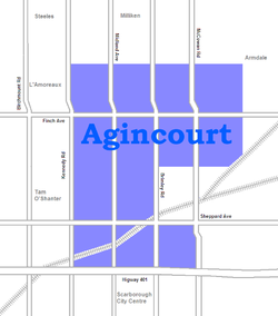 |
|
| Alderwood Alderwood, Toronto Alderwood is a neighbourhood in the city of Toronto, Ontario, Canada. It is in the western section of Toronto, formerly the city of Etobicoke. It is bounded by the Etobicoke Creek to the west, the Gardiner Expressway to the north, the CPR railway to the east and the CNR railway to the... |
0211.00, 0212.00 | 11,656 | 4.94 | 2360 | -4.0 | 35,239 | 8.8 | 8.5 | Polish (6.2%) | ||
| Alexandra Park | 0039.00 | 4,355 | 0.32 | 13,609 | 0.0 | 19,687 | 13.8 | 28.0 | Cantonese (17.9%) | 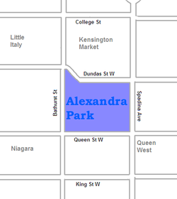 |
|
| Allenby | 0140.00 | 2,513 | 0.58 | 4333 | -1.0 | 245,592 | 5.2 | 3.4 | Russian (1.4%) | ||
| Amesbury Amesbury, Toronto Amesbury is a neighbourhood in Toronto, Ontario, Canada, formerly in North York before it was amalgamated into Toronto in 1998. It is part of federal and provincial electoral district York South—Weston, and Toronto electoral wards 11: York South—Weston and 12: York South-Weston .Its borders are... |
0280.00, 0281.01, 0281.02 | 17,318 | 3.51 | 4,934 | 1.1 | 27,546 | 16.4 | 19.7 | Spanish (6.1%) | ||
| Armour Heights | 0298.00 | 4,384 | 2.29 | 1914 | 2.0 | 116,651 | 10.8 | 16.1 | Russian (9.4%) | ||
| Banbury | 0267.00 | 6,641 | 2.72 | 2442 | 5.0 | 92,319 | 6.1 | 4.8 | Unspecified Chinese (5.1%) | ||
| Bathurst Manor Bathurst Manor Bathurst Manor is a neighbourhood located in the North York district of Toronto, Ontario, Canada. It sits on a plateau bounded on the north by Finch Avenue West, on the west by Dufferin Street, on the east by the Don River , and on the south by Sheppard Avenue West. The area is also regarded as... |
0297.01, 0310.01, 0310.02 | 14,945 | 4.69 | 3187 | 12.3 | 34,169 | 13.4 | 18.6 | Russian (9.5%) | ||
| Bay Street Corridor | 0062.01 | 4,787 | 0.11 | 43,518 | 3.0 | 40,598 | 17.1 | 49.3 | Mandarin (9.6%) | ||
| Bayview Village Bayview Village Bayview Village is an affluent neighbourhood in Toronto, Ontario, Canada, formerly in North York before it was amalgamated into Toronto in 1998. It is part of the federal and provincial electoral district Willowdale, and Toronto electoral wards 24: Willowdale and 33: Don Valley North... |
0305.01, 305.02 | 12,280 | 4.14 | 2,966 | 41.6 | 46,752 | 14.4 | 15.6 | Cantonese (8.4%) | 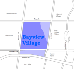 |
|
| Bayview Woods – Steeles | 0323.01, 0323.02, 0324.01 | 13,298 | 4.07 | 3267 | -1.5 | 41,485 | 11.2 | 13.9 | Cantonese (9.3%) | ||
| Bedford Park Bedford Park, Toronto Bedford Park began as a farming hamlet north of Toronto. The hamlet was a popular stopover for farmers making their way to market in the city. The neighbourhood was likely named after the Bedford Park Hotel, which opened in 1873 at the southwest corner of Yonge Street and Fairlawn Avenue, just... |
0141.01, 0141.02, 0142.00 | 13,749 | 2.27 | 6057 | -1.4 | 80,827 | 15.2 | 10.1 | Greek (0.7%) | ||
| Bendale Bendale Bendale, also called Cedarbrae, is a neighbourhood in the eastern part of Toronto, Ontario, Canada, in Scarborough. The area is ethnically diverse, like much of Toronto, but has a greater proportion of South Asian population, especially Tamils.... |
0353.02, 0354.00, 0367.02, 0368.00, 0369.00 | 28,945 | 8.49 | 3409 | 12.9 | 29,723 | 13.0 | 10.4 | Tamil 3.7% | ||
| Birch Cliff Birch Cliff Birch Cliff is a neighbourhood in Toronto, Canada. It is located in the southwest part of the old city of Scarborough running along shore of Lake Ontario atop the eastern part of the Scarborough Bluffs. The area was first developed as the home of the Toronto Hunt Club in 1895 when the region was... |
0338.00, 0339.00 | 12,266 | 3.48 | 3525 | -3.0 | 48,965 | 11.4 | 15.2 | Unspecified Chinese (0.9%) | ||
| Bloor West Village Bloor West Village Bloor West Village is a shopping district in Toronto, Ontario, Canada. Located along Bloor Street, it encompasses all businesses along Bloor Street between Jane Street and Ellis Park Road, consisting of more than 400 shops, restaurants and services. The mix of stores include specialty clothing... |
0104.00 | 5,175 | 0.74 | 6993 | -2.0 | 55,578 | 20.7 | 8.3 | Ukrainian (3.6%) | ||
| Bracondale Hill Bracondale Hill Bracondale Hill, also known as Hillcrest, is a neighbourhood located in Toronto, Ontario, Canada. Annexed by the old City of Toronto in 1909 and developed in 1911 from the Turner estate, Bracondale Hill is in the western end of midtown Toronto and stretches above Davenport Road and below St. Clair... |
0114.00 | 5,343 | 0.62 | 8618 | -3.0 | 41,605 | 18.2 | 24.2 | Greek (4.8%) | 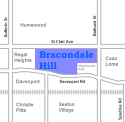 |
|
| Branson | 0309.00, 0317.05 | 8,017 | 1.25 | 6414 | -3.8 | 27,156 | 18.0 | 27.2 | Russian (24.1%) | ||
| Bridle Path Bridle Path, Toronto The Bridle Path upscale residential neighbourhood in the former city of North York, now part of Toronto, Ontario, Canada, that is characterized by large multi-million dollar mansions and two to four acre lot sizes. It is often referred to as "Millionaires' Row"... |
0264.00 | 1,540 | 3.46 | 445 | 11.0 | 314,107 | 7.1 | 2.3 | Cantonese (12.0%) | 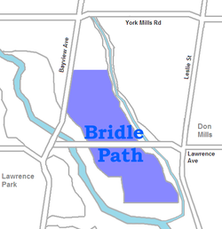 |
|
| Brockton Brockton Village Brockton Village is a neighbourhood in Toronto, Ontario, Canada. It comprises a section of the old Town of Brockton which was annexed by the City of Toronto in 1884. The town encompassed the area from Bloor Street on the north, Dufferin Street on the east, High Park on the west and ranged from... |
0046.00, 0053.00 | 9,039 | 1.1 | 8217 | -9.5 | 27,260 | 22.3 | 17.3 | Portuguese (19.9%) | ||
| Cabbagetown Cabbagetown, Toronto Cabbagetown is a neighbourhood located on the east side of downtown Toronto, Ontario, Canada. It comprises "the largest continuous area of preserved Victorian housing in all of North America", according to the Cabbagetown Preservation Association.... |
0066.00, 0067.00, 0068.00 | 11,120 | 1.4 | 7943 | 5.3 | 50,398 | 18.5 | 29.6 | Unspecified Chinese (1.6%) | 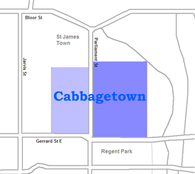 |
|
| Caribou Park | 0277.00 | 4,097 | 1.02 | 4017 | -2.0 | 103,703 | 8.4 | 7.6 | Tagalog (2.9%) | ||
| Carleton Village Carleton village Carleton used to be a separate village or small hamlet one mile east of the centre of Penrith, Cumbria, England. Today, it is a rural suburb in an area of Penrith that has seen the most growth of housing in the past 30 years.- Name origin :... |
0108.00 | 6,544 | 0.74 | 8843 | -4.0 | 23,301 | 19.0 | 19.9 | Portuguese (17.0%) | ||
| Casa Loma | 0118.00 | 3,597 | 0.67 | 5369 | 23.0 | 82,203 | 18.1 | 32.9 | Korean (1.8%) | 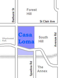 |
|
| Centennial | 0236.01, 0236.02 | 12,565 | 4.94 | 2544 | 0.5 | 34,867 | 11.5 | 8.8 | Polish (2.7%) | ||
| Chaplin Estates | 0129.00 | 4,906 | 0.93 | 5275 | 1.0 | 81,288 | 22.7 | 24.5 | French (1.2%) | ||
| Christie Pits Christie Pits Christie Pits Park, originally Willowvale Park, is a Toronto public recreational area located at 750 Bloor Street West at Christie Street, just west from the TTC Christie subway station... |
0094.00 | 5,124 | 0.64 | 8006 | -5.0 | 30,556 | 18.8 | 15.3 | Portuguese (11.9%) | ||
| Church and Wellesley Church and Wellesley Church and Wellesley is an LGBT-oriented community located in Toronto, Ontario, Canada. It is roughly bounded by Gerrard Street to the south, Yonge Street to the west, Charles Street to the north, and Jarvis Street to the east, with the core commercial strip located along Church Street from... |
0063.01, 0063.02 | 13,397 | 0.55 | 24,358 | 8.8 | 37,653 | 25.1 | 57.0 | Spanish (1.8%) | 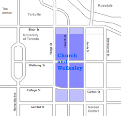 |
|
| Clairville | 0248.03, 0249.03 | 8,506 | 6.71 | 1268 | -3.3 | 26,610 | 13.2 | 7.2 | Punjabi (12.0%) | ||
| Clairlea | 0340.00, 0348.00 | 11,104 | 3.58 | 3102 | 1.8 | 33,392 | 18.1 | 12.7 | Filipino (4.3%) | ||
| Cliffcrest Cliffcrest Cliffcrest is a neighborhood in the city of Toronto, Ontario, Canada, located in the district of Scarborough. The neighborhood runs along Lake Ontario to the south and is bordered by Midland Ave. to the west, the Canadian National Railway to the north, and Bellamy Rd. to the east... |
0333.00, 0334.00, 0335.00 | 14,531 | 7.01 | 2073 | -2.9 | 38,182 | 12.5 | 12.2 | Tamil (1.5%) | 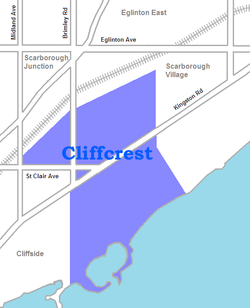 |
|
| Cliffside | 0336.00, 0337.00 | 9,386 | 2.45 | 3831 | -6.3 | 32,701 | 14.8 | 11.4 | Cantonese (2.3%) | ||
| Corktown Corktown, Toronto Corktown is a residential neighbourhood in downtown Toronto, Ontario, Canada. It is just south of Regent Park and north of the Gardiner Expressway, between Berkeley Street to the west and the Don River to the east, Shuter Street to Lake Shore Boulevard East, this area also includes the Distillery... |
0016.00 | 4,484 | 0.67 | 6693 | 77.0 | 54,681 | 15.5 | 17.6 | Spanish (2.1%) | 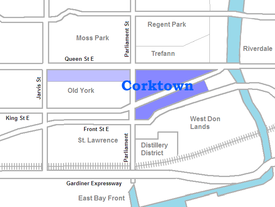 |
|
| Crescent Town | 0190.01 | 8,157 | 0.4 | 20,393 | -10.0 | 23,021 | 24.5 | 20.3 | Bengali (18.1%) | 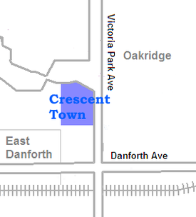 |
|
| Cricket Club | 0275.00 | 5,504 | 1.96 | 2808 | 3.0 | 104,362 | 8.7 | 15.4 | Filipino (1.4%) | ||
| Davenport | 0109.00, 0115.00 | 8,781 | 0.99 | 8870 | -6.9 | 28,335 | 19.8 | 18.2 | Portuguese (17.1%) | ||
| Davisville | 0126.00, 0127.00, 0128.02, 0128.03, 0128.04 | 23,727 | 3.14 | 7556 | 4.5 | 55,735 | 26.0 | 31.7 | Persian (1.5%) |  |
|
| Deer Park Deer Park, Toronto Deer Park is a neighbourhood in Toronto, Ontario, Canada, centred on the intersection of Yonge Street and St. Clair Avenue; its boundaries are the Vale of Avoca section of Rosedale ravine in the east, Farnham Avenue and Jackes Avenue in the south, Avenue Road and Oriole Parkway in the west, the... |
0121.00, 0122.00, 0123.00, 0124.00 | 15,165 | 1.46 | 10,387 | 5.2 | 80,704 | 26.4 | 41.3 | Russian (1.1%) | ||
| Discovery District Discovery District The Discovery District is an area of downtown Toronto, Ontario, Canada, that features a high concentration of hospitals and research institutions, particularly those related to biotechnology... |
0035.00 | 4,619 | 0.66 | 6998 | 8.0 | 41,998 | 12.7 | 32.1 | Unspecified Chinese (6.5%) |  |
|
| Distillery District/West Don Lands West Don Lands The West Don Lands are the site of a planned neighbourhood under construction in Toronto, Ontario, Canada. The area is bordered by the Don River, King Street, Parliament Street and the rail line adjacent to the Gardiner Expressway.... |
0017.00 | 6,378 | 1.33 | 4795 | -1.0 | 40,617 | 19.5 | 37.5 | French (2.5%) |  |
|
| Don Mills Don Mills Don Mills is a mixed-use neighbourhood in the North York district of Toronto, Canada. It was developed to be a self-supporting "new town" and was at the time located outside of Toronto proper. Consisting of residential, commercial and industrial sub-districts, it was planned and developed by... |
0263.02, 0263.03, 0263.04, 0268.00, 0269.02 | 21,372 | 8.99 | 2377 | 11.9 | 47,515 | 10.8 | 18.6 | Unspecified Chinese (3.9%) | ||
| Don Valley Village Don Valley Village Don Valley Village is a neighbourhood in the city of Toronto, Ontario, Canada. It is located north of Highway 401, and is bounded by Sheppard Avenue to the south, Leslie Street to the west, Finch Avenue to the north and Highway 404 to the east... |
0303.00, 0304.01, 0304.02, 0304.03, 0304.04, 0304.05, 0304.06 | 29,740 | 5.16 | 5764 | -1.3 | 30,442 | 17.1 | 16.6 | Unspecified Chinese (9.7%) | ||
| Dorset Park Dorset Park Dorset Park is a neighbourhood in Scarborough, a district of the city of Toronto, Ontario, Canada. The neighbourhood is located in western Scarborough, bordered by Highway 401 to the North, Midland Avenue to the East, Lawrence Avenue to the South, Birchmount Road to the west, and Kennedy Road... |
0352.00, 0370.02, 0370.03 | 14,189 | 4.26 | 3331 | 7.8 | 26,525 | 15.2 | 9.6 | Tamil (9.5%) |  |
|
| Dovercourt Park | 0095.00, 0096.00 | 8,497 | 0.87 | 9767 | -9.2 | 28,311 | 21.9 | 15.1 | Portuguese (13.1%) | ||
| Downsview | 0289.00, 0290.00, 0291.01, 0291.02, 0292.00, 0294.01, 0294.02, 0295.00, 0296.00 | 36,613 | 16.13 | 2270 | -5.0 | 26,751 | 14.4 | 18.3 | Italian (11.7%) | ||
| Dufferin Grove Dufferin Grove Dufferin Grove is a neighbourhood located in Toronto, Ontario, Canada, west of downtown. The neighbourhood is bordered by Bloor Street West to the north, Ossington Ave to the east, College Street to the south, and Dufferin Street to the west.-Character:... |
0045.00, 0054.00 | 9,875 | 0.99 | 9975 | -7.1 | 27,961 | 23.8 | 28.4 | Portuguese (15.2%) | ||
| Earlscourt | 0107.00, 0110.00, 0111.00, 0112.00 | 17,240 | 2.24 | 7696 | -1.7 | 26,672 | 17.7 | 8.5 | Portuguese (18.9%) | ||
| East Danforth East Danforth East Danforth is a neighbourhood in Toronto, Canada. It is located on the eastern part of Danforth Avenue in the old city of Toronto. It stretches from the eastern edge of Greektown by Jones Avenue to the boundary of Scarborough at Victoria Park Avenue. The area is covered by two business... |
0075.00, 0076.00, 0080.01, 0080.02, 0081.00, 0082.00 | 21,440 | 2.5 | 8576 | -6.3 | 33,847 | 24.2 | 18.3 | Cantonese (4.2%) | 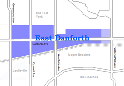 |
|
| Eatonville Eatonville, Toronto Eatonville is a neighbourhood in the Etobicoke community of the city of Toronto, Ontario, Canada. Located west of the area known as Islington, Eatonville is bisected by Highway 427, with the community generally located north of Dundas Street West and south of Rathburn Road... |
0213.00, 0221.02, 0222.01, 0222.02 | 19,131 | 11.26 | 1699 | 4.3 | 36,206 | 12.6 | 13.4 | Serbian (3.2%) | ||
| Eglinton East | 0353.03, 0353.04, 0355.02, 0355.03, 0355.04 | 22,387 | 3.23 | 6931 | -1.0 | 25,307 | 19.4 | 19.1 | Tamil (9.7%) | ||
| Elia (Jane and Finch Jane and Finch Jane and Finch is a neighbourhood located in northwestern North York, a district of Toronto, Ontario, Canada. The area is roughly bounded by Highway 400 to the west, Driftwood Avenue to the east, Grandravine Drive to the south, and Shoreham Drive to the north... ) |
0312.02, 0312.03, 0312.04, 0312.05, 0312.06, 0312.07, 0316.01, 0316.03, 0316.04, 0316.05, 316.06 | 48,003 | 7.66 | 6267 | -10.0 | 22,691 | 13.0 | 18.8 | Vietnamese (6.9%) | ||
| Eringate | 235.01, 235.02 | 8,008 | 2.44 | 3282 | -3.4 | 34,789 | 10.9 | 4.0 | Portuguese (3.4%) | ||
| Fairbank Fairbank, Toronto Fairbank is a neighbourhood located in the city of Toronto. It covers a large central portion of the former city of York, Ontario centered on the intersection of Dufferin Street and Eglinton Avenue. The western border is the CNR lines... |
160.00, 161.00, 162.00, 163.00, 169.01, 169.02, 170.00 | 34,121 | 4.42 | 7720 | -3.6 | 28,403 | 21.6 | 16.4 | Portuguese (11.3%) | ||
| Fashion District | 0011.00 | 4,642 | 0.98 | 4737 | 123.0 | 63,282 | 15.5 | 26.2 | Portuguese (1.1%) | ||
| Financial District Financial District, Toronto The Financial District is a business district in Toronto, Ontario, Canada, within the downtown core. It was originally planned as New Town in 1796 as an extension of the Town of York . It is the main financial district in Toronto, and is the financial heart of Canada... |
0014.00 | 548 | 0.47 | 1166 | 6.0 | 63,952 | 18.2 | 17.3 | Japanese (1.8%) | 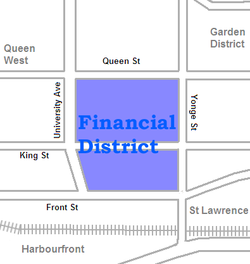 |
|
| Flemingdon Park Flemingdon Park Flemingdon Park is a multicultural community in Toronto, Ontario, Canada, located in the North York district of the city. It is part of federal and provincial electoral district Don Valley West, and Toronto electoral ward 26: Don Valley West... |
0260.01, 0260.03, 0260.04, 0260.05 | 21,287 | 2.43 | 8760 | -6.0 | 23,471 | 16.6 | 19.6 | Urdu (6.3%) | ||
| Forest Hill Forest Hill, Toronto Forest Hill is an affluent neighbourhood in central Toronto, Ontario, Canada. Along with Lawrence Park, Rosedale, and The Bridle Path, it is one of Toronto’s wealthiest neighbourhoods.-History:... |
0130.00, 0131.00, 0132.00, 0133.00, 0134.00 | 24,056 | 4.35 | 5530 | -0.2 | 101,631 | 14.8 | 21.9 | Russian (2.4%) | ||
| Fort York Fort York (neighbourhood) The Fort York neighbourhood, also known as Garrison, in Toronto, Ontario, Canada is located along and south of CN and CP railway corridors... /Liberty Village Liberty Village Liberty Village is a neighbourhood in Toronto, Ontario, Canada. It is bounded at the north by King Street West, the west by Dufferin Street, the south by the Gardiner Expressway, the east by Strachan Avenue, and the northeast by the CP railway tracks... |
0008.00 | 3,821 | 2.13 | 1794 | 126.0 | 46,086 | 22.8 | 27.9 | Hindi (1.7%) | ||
| Garden District | 0034.00 | 8,240 | 0.52 | 15,846 | 17.0 | 37,614 | 17.0 | 35.5 | Unspecified Chinese (3.0%) | ||
| Glen Park Glen Park, Toronto Glen Park is a neighbourhood in the city of Toronto, Ontario, Canada, located in the district of North York. It is bounded by Lawrence Avenue to the north, Bathurst Street to the east, a line south of Stayner Avenue to the south, and the CNR tracks to the west. Prior to the amalgamation of... |
0278.00, 0279.01, 0279.02 | 18,426 | 4.13 | 4462 | 4.4 | 35,022 | 13.6 | 17.0 | Italian (9.3%) | 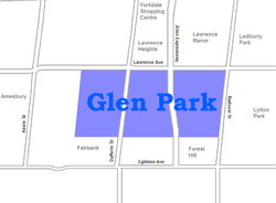 |
|
| Governor's Bridge/Bennington Heights | 0186.00 | 2,112 | 1.87 | 1129 | 4.0 | 129,904 | 7.1 | 13.3 | Polish (1.4%) | ||
| Grange Park Grange Park (neighbourhood) Grange Park is a neighbourhood in downtown Toronto, Ontario, Canada. It is bounded on the west by Spadina Avenue, on the north by College Street, on the east by University Avenue and on the south by Queen Street. It is within the 'Kensington-Chinatown' City of Toronto planning neighbourhood. Its... |
0036.00, 0037.00 | 9,007 | 0.84 | 10,793 | -1.0 | 35,277 | 13.3 | 35.6 | Unspecified Chinese (14.8%) | ||
| Graydon Hall | 0269.01 | 4,714 | 0.71 | 6639 | -15.0 | 23,350 | 15.6 | 35.2 | Persian (11.8%) | ||
| Guildwood Guildwood Guildwood, also known as Guildwood Village, is a historic and residential neighbourhood in Scarborough, Toronto, Ontario, Canada. It is located along the Scarborough Bluffs, south of Kingston Road, from Grey Abbey Trail in the east to the end of Sylvan Avenue in the west.-History:Guildwood village... |
0330.00, 0331.01, 0331.04 | 12,820 | 4.77 | 2688 | -2.0 | 40,806 | 11.6 | 8.0 | Persian (1.2%) | ||
| Harbord Village | 0059.00, 0060.00 | 5,906 | 0.64 | 9,228 | 2.4 | 40,308 | 16.8 | 24.0 | Portuguese (4.1%) |  |
|
| Harbourfront Harbourfront Harbourfront is a neighbourhood on the northern shore of Lake Ontario within the downtown core of the city of Toronto, Canada. Part of the Toronto Waterfront, Harbourfront extends west from Yonge Street to Bathurst Street along Queen's Quay. East of Yonge to Parliament St... / CityPlace CityPlace, Toronto CityPlace is the name given to a large section of former railway land in downtown Toronto, Ontario, Canada that has been redeveloped for multi-use purpose. The term has been more recently used for a large up-scale multi-tower condo development in the Harbourfront district. When completed, this area... |
0012.00, 0013.00 | 14,368 | 1.87 | 9228 | 94.3 | 69,232 | 16.0 | 31.3 | Unspecified Chinese (2.4%) |  |
|
| Harwood | 0155.00 | 3,375 | 0.78 | 4327 | 0.0 | 22,136 | 12.3 | 17.8 | Portuguese (19.0%) | ||
| Henry Farm Henry Farm Henry Farm is an officially designated neighbourhood in the City of Toronto, Ontario, Canada. It is located in the north central part of town within the district of North York.... |
0301.01 | 2,790 | 0.91 | 3066 | -6.0 | 56,395 | 15.6 | 15.9 | Mandarin (3.9%) | ||
| High Park North High Park North High Park North, or often, simply 'High Park', after the park, is a neighbourhood in Toronto, Ontario, Canada. It is bounded on the south by Bloor Street, on the west by Runnymede Road, on the north by Annette Street, Quebec Avenue and Humberside Avenue, and on the east by the CNR/CPR railway... |
0099.00, 0100.00, 0102.01, 0102.02, 0102.03, 0103.00 | 22,746 | 2.18 | 10,434 | -1.6 | 46,437 | 27.5 | 32.8 | Polish (3.0%) | ||
| Highland Creek Highland Creek, Toronto Highland Creek is a neighbourhood in south-east Scarborough in Toronto, Ontario, Canada that lies along the southern portion of the river of the same name... |
0362.02, 0362.03 | 12,853 | 5.13 | 2505 | -0.1 | 33,640 | 9.7 | 1.8 | Tamil (5.1%) | ||
| Hillcrest Hillcrest Village Hillcrest Village is a neighbourhood located in the district of North York at the northernmost tip of the city of Toronto, Ontario, Canada. Hillcrest Village is considered by some to be part of the Don Valley Village, the neighbourhood directly to the south, however it is quite distinct... |
0324.02, 0324.03, 0324.05, 0324.06 | 18,327 | 5.35 | 3426 | -0.4 | 33,465 | 12.0 | 8.0 | Unspecified Chinese (13.9%) | ||
| Hoggs Hollow | 0266.00 | 3,123 | 2.76 | 1132 | 2.0 | 222,560 | 4.3 | 2.9 | Unspecified Chinese (2.4%) |  |
|
| Humber Bay Shores | 0200.00, 0201.00 | 10,775 | 1.42 | 7588 | -5.7 | 39,186 | 15.7 | 31.6 | Russian (5.2%) | ||
| Humber Heights | 0241.00, 0242.00 | 4,674 | 1.69 | 2766 | 8.3 | 39,738 | 10.1 | 9.7 | Spanish (4.1%) | ||
| Humber Summit Humber Summit Humber Summit is one of the northernmost neighbourhoods in Toronto, Ontario, located in the North York district of the city. It is bounded by Steeles Avenue to the north, Highway 400 to the east, Finch Avenue to the south, and follows the Humber River to the west.-Character:In the 1840s, Humber... |
0315.01, 0315.02, 0315.03 | 12,766 | 7.89 | 1618 | 2.1 | 26,117 | 7.3 | 7.6 | Italian (15.1%) | ||
| Humber Valley Village | 0230.01, 0230.02. 0231.00 | 14,453 | 5.45 | 2652 | -0.1 | 80,618 | 12.0 | 17.8 | Ukrainian (3.9%) | ||
| Humberlea | 0293.00 | 4,327 | 2.0 | 2164 | -2.0 | 30,907 | 8.7 | 7.9 | Italian (11.1%) | ||
| Humbermede Humbermede Humbermede, often called Emery, is a neighbourhood of Toronto, Ontario, Canada. Humbermede, like many of the "Humber" neighbourhoods in the city, gets its name from the Humber River... |
0313.00, 0314.01, 0314.02 | 14,778 | 4.35 | 3397 | 1.1 | 24,297 | 11.8 | 14.6 | Punjabi (9.7%) | ||
| Humberwood Humberwood Humberwood is a small neighbourhood in Rexdale, Etobicoke, Toronto, Canada. Humberwood is named after the Humber River, which flows along the eastern edge of Etobicoke.-Boundaries:... |
0247.01 | 7,319 | 17.4 | 421 | 8.0 | 29,576 | 7.9 | 7.0 | Punjabi (26.7%) | ||
| Humewood–Cedarvale | 0164.00, 0165.00, 0166.00, 0167.01, 0167.02, 0168.00 | 27,515 | 3.19 | 8624 | -7.8 | 40,404 | 24.2 | 26.0 | Spanish (3.6%) | ||
| Ionview Ionview Ionview is a neighbourhood in Toronto, Ontario, in the district of Scarborough. It is bounded by Birchmount Road to the west, the hydro transmission corridor north of Ranstone Gardens to the north, the CNR railway to the east, and Eglinton Avenue East, Kennedy Road and the CNR railway to the south... |
0346.02, 0351.01, 0351.02 | 13,025 | 1.94 | 6714 | -4.0 | 25,078 | 21.1 | 22.5 | Filipino (6.5%) | 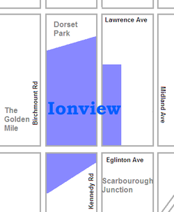 |
|
| Islington – Six Points | 0223.00, 0224.00, 0225.01, 0225.02 | 16,508 | 4.02 | 4106 | 3.7 | 43,570 | 17.1 | 22.2 | Korean (4.9%) | ||
| Junction Triangle Junction Triangle Junction Triangle is a neighbourhood in Toronto, Canada. It is located in the city's west end, just west of Lansdowne Avenue. The area is a triangle surrounded on all three sides by railway lines. The CNR/CPR mainline to the west, the CNR railway lines to the east, and the CPR east-west railway... |
0098.00 | 6,666 | 0.72 | 9258 | -6.0 | 28,067 | 20.0 | 18.8 | Portuguese (13.0%) | ||
| Kensington Market Kensington Market Kensington Market is a distinctive multicultural neighbourhood in Downtown Toronto, Ontario, Canada. The Market is an older neighbourhood and one of the city's most well-known. In November 2006, it was designated a National Historic Site of Canada. Robert Fulford wrote in 1999 that "Kensington... |
0038.00 | 3,740 | 0.36 | 10,389 | 3.0 | 23,335 | 15.0 | 25.1 | Cantonese (14.3%) | 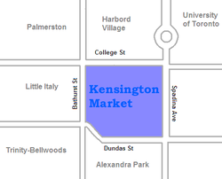 |
|
| Kingsview Village | 0239.00, 0243.01, 0243.02 | 16,254 | 4.05 | 4013 | -6.2 | 32,004 | 11.8 | 14.6 | Somali (7.0%) | ||
| Lambton Lambton, Toronto Lambton is a neighbourhood in the city of Toronto, situated on the east bank of the Humber River north and south of Dundas Street West. It is bounded on the north by Black Creek, on the east by Jane Street and on the south by St. Mark's Road. The area west of Gooch Road is also known as "Warren... |
0151.00, 0154.00 | 9,654 | 2.74 | 3523 | -3.2 | 30,920 | 14.2 | 15.9 | Portuguese (3.9%) | ||
| L'Amoreaux L'Amoreaux L'Amoreaux is a neighbourhood in Toronto, Ontario, Canada, situated east of Victoria Park Avenue, south of McNicoll Avenue, west of Kennedy Road and north of Huntingwood Drive. L'Amoreaux is named after Josue L'Amoreaux , a French Huguenot loyalist who settled in the area... |
0375.01, 0375.04, 0375.05, 0376.01, 0376.02, 0376.08, 0376.11,0376.12 | 45,862 | 7.15 | 6414 | 0.9 | 26,375 | 13.4 | 11.4 | Unspecified Chinese (13.9%) | ||
| Lansing | 299.00 | 10,052 | 3.06 | 3285 | 35.0 | 46,631 | 18.7 | 17.0 | Persian (4.7%) | ||
| Lawrence Heights Lawrence Heights Lawrence Heights is a neighbourhood in Toronto, Ontario, Canada. It is located north-west of central Toronto, in the district of North York. The neighbourhood is bounded by Lawrence Avenue to the south, Highway 401 to the north, Allen Road to the east and Dufferin Street to the west... |
286.00 | 3,769 | 3.2 | 1178 | 15.0 | 29,867 | 15.0 | 13.9 | Italian (15.0%) | ||
| Lawrence Manor Lawrence Manor Lawrence Manor is a neighbourhood in the city of Toronto, Ontario, Canada. The neighbourhood is bounded by Bathurst Street on the east, Highway 401 to the north, the Allen to the west, and Lawrence Avenue to the south... |
0287.01, 0287.02 | 13,750 | 2.14 | 6425 | 7.4 | 36,361 | 15.9 | 23.8 | Filipino (7.2%) | 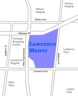 |
|
| Lawrence Park Lawrence Park, Toronto Lawrence Park is one of Toronto, Canada's most affluent residential neighbourhoods, along with Rosedale, the Bridle Path, and Forest Hill. It is also one of the wealthiest neighbourhoods in Canada.... |
0138.00, 0265.00 | 6,653 | 3.64 | 1828 | -5.1 | 214,110 | 8.3 | 4.6 | French (0.8%) | 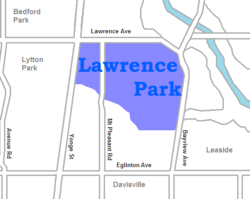 |
|
| Leaside Leaside Leaside is a neighbourhood in Toronto, Ontario, Canada. The area takes its name from William Lea and the Lea family, who settled there in the early years of the nineteenth century. The area first developed as farmland along with Toronto through the nineteenth century. It was incorporated as a... |
0195.00, 0196.00 | 13,876 | 2.81 | 4938 | 3.0 | 82,670 | 9.7 | 10.5 | Bulgarian (0.4%) | ||
| Ledbury Park | 0276.01, 0276.02 | 12,360 | 2.5 | 4944 | 3.5 | 83,853 | 9.5 | 12.2 | Filipino (1.4%) | ||
| Leslieville Leslieville Leslieville is a neighbourhood in Toronto, Ontario, Canada east of the Don River bounded by the Canadian National railway line and Gerrard Street to the north, Empire Avenue to the west, Eastern Avenue to south, and Coxwell Avenue to the east.-History:... |
0026.00, 0027.00, 0028.00, 0073.00, 0074.00 | 23,567 | 2.69 | 8761 | -7.3 | 30,886 | 19.9 | 15.4 | Cantonese (9.4%) | 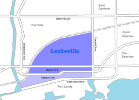 |
|
| Little Italy Little Italy, Toronto Little Italy, sometimes referred to as College Street West, is a district in Toronto, Ontario, Canada. It is well known for its numerous Italian Canadian restaurants and businesses. There is also a significant Latin American and Portuguese community in the area... |
0041.00, 0042.00 | 7,917 | 0.81 | 9774 | -6.1 | 31,231 | 15.5 | 17.0 | Portuguese (17.4%) | 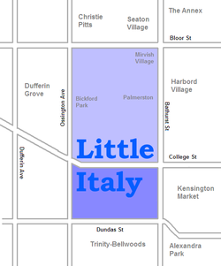 |
|
| Little Portugal Little Portugal, Toronto Little Portugal is a neighbourhood and ethnic enclave in Toronto, Ontario, Canada. It is located west of downtown in the "Old" City of Toronto. It is bounded on the west by Lansdowne Avenue, on the north by College Street, on the east by Ossington Avenue and on the south by the CNR/CPR mainline... |
0044.00 | 5,013 | 0.49 | 10,231 | -10.0 | 29,224 | 16.6 | 21.6 | Portuguese (23.8%) | ||
| Long Branch Long Branch, Toronto The former Village of Long Branch is a neighbourhood in the south-west of Toronto, Ontario, Canada. It is located in the south-west corner of the former Township of Etobicoke and was a partially-independent municipality from 1930-1967... |
0206.01, 0206.02 | 9,625 | 2.22 | 4336 | -7.4 | 37,288 | 14.2 | 23.0 | Polish (4.5%) | ||
| Lytton Park | 0139.00 | 6,494 | 1.28 | 5073 | 5.0 | 127,356 | 15.1 | 12.9 | Serbian (0.9%) | ||
| Malvern Malvern, Toronto Malvern is a neighbourhood in Toronto, Ontario, Canada, with a population of 44,315. It is located in the northeast corner of the city, in the district of Scarborough. Scarborough was merged with five other municipalities and a regional government to form the new City of Toronto in 1998... |
0378.03, 0378.04, 0378.05, 0378.06, 0378.11, 0378.12, 0378.16, 0378.17 | 44,324 | 8.86 | 5003 | 1.5 | 25,677 | 13.6 | 8.2 | Tamil (12.2%) | ||
| Maple Leaf Maple Leaf, Toronto Maple Leaf is a neighbourhood in the city of Toronto, Ontario, Canada. It is located in the southwest of the North York district. Its approximate borders are Lawrence Avenue to the south, Jane Street to the west, Highway 401 to the north, The CNR rail lines east of Keele Street to the... |
0283.01, 0283.02, 0284.00, 285.00 | 20,313 | 4.59 | 4425 | 1.4 | 27,611 | 11.8 | 18.8 | Italian (13.0%) | ||
| Markland Wood Markland Wood Markland Wood is a residential neighbourhood located in Etobicoke, in the City of Toronto, Ontario, Canada. It is bounded by Etobicoke Creek to the west, Elmcrest Creek to the east and surrounded by the Markland Wood Country Club... |
0220.00, 0221.01 | 10,240 | 2.92 | 3507 | 1.0 | 51,695 | 9.2 | 9.7 | Polish (3.4%) | ||
| Maryvale Maryvale, Toronto Maryvale is a neighbourhood in the Scarborough section of Toronto, Canada. It is located on the edge of Scarborough with its western border being Victoria Park Avenue... |
0372.00, 0373.00 | 8,800 | 2.28 | 3860 | -3.2 | 30,944 | 12.3 | 11.4 | Filipino (4.1%) | ||
| Milliken Milliken, Ontario Milliken or Milliken Mills is a neighbourhood in the city of Toronto and Markham, Ontario. It is located in the North East section of Scarborough and South East section of Markham... |
0377.06, 0377.07, 0378.18, 0378.19, 0378.20, 0378.21, 0378.22 | 26,272 | 7.19 | 3654 | -2.0 | 25,243 | 12.3 | 3.9 | Cantonese (26.6%) | ||
| Mimico Mimico The historic Town of Mimico is a neighbourhood in the south-western part of Toronto, Ontario, Canada. It is located in the south-east corner of the former Township of Etobicoke, and was an independent municipality from 1911 to 1967.... |
0202.00, 0203.00, 0209.00, 0210.00 | 14,198 | 5.4 | 2629 | 15.4 | 47,011 | 11.6 | 15.5 | Polish (3.6%) | ||
| Moore Park Moore Park, Toronto Moore Park is a neighbourhood in Toronto, Ontario, Canada. It lies along both sides of St. Clair Avenue East between the Vale of Avoca section of Rosedale ravine and Moore Park ravine . The northern boundary is Mount Pleasant Cemetery and the southern the Canadian Pacific Railway tracks.The... |
0125.00 | 4,474 | 1.13 | 3959 | -2.0 | 154,825 | 11.0 | 7.5 | French (1.1%) | 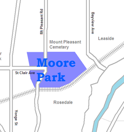 |
|
| Morningside | 0363.02, 0363.04, 0363.05 | 11,472 | 2.79 | 4112 | 0.3 | 27,139 | 14.9 | 13.2 | Tamil (10.8%) | ||
| Mount Dennis Mount Dennis Mount Dennis is a neighbourhood in Toronto, Ontario, Canada, bordered by the intersection of Jane Street and Weston Road to the north, and Black Creek to the east and south, as the creek curves parallel to Alliance Avenue before crossing under Jane Street on its way to drain into the Humber River,... |
0156.01, 0156.02, 0157.00, 0173.00, 0174.00 | 21,284 | 3.29 | 6469 | -3.1 | 23,910 | 18.2 | 19.9 | Spanish (7.3%) | ||
| New Toronto New Toronto The historic Town of New Toronto is a neighbourhood in the south-west end of Toronto, Ontario, Canada. It is located in the south-centre of the former Township of Etobicoke and was an independent municipality from 1913 to 1967, one of the former 'Lakeshore Municipalities'... |
0204.00, 0207.00, 0208.00 | 10,455 | 2.71 | 3858 | -5.8 | 33,415 | 13.0 | 25.6 | Polish (4.6%) | ||
| Newtonbrook | 0318.00, 0319.00, 0320.01, 0320.02, 0321.01, 0321.02, 0322.00 | 36,046 | 8.77 | 4110 | 0.3 | 33,428 | 16.6 | 14.3 | Russian (8.8%) | ||
| Niagara | 0010.02 | 6,524 | 0.55 | 11,862 | -4.0 | 44,611 | 21.2 | 21.4 | Portuguese (4.0%) | 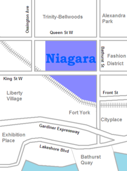 |
|
| North York City Centre North York Centre North York Centre is a town centre in North York, Toronto, Ontario, Canada. Prior to the Amalgamation of Toronto in 1998, it was considered the central business district of the former city of North York... |
0307.01 | 10,427 | 0.28 | 37,239 | 33.0 | 34,330 | 19.0 | 19.5 | Unspecified Chinese (10.1%) | ||
| Oakridge | 0341.02, 0341.03, 0341.04 | 13,368 | 1.86 | 7187 | -2.3 | 21,155 | 20.8 | 27.1 | Bengali (12.6%) | ||
| O'Connor-Parkview O'Connor-Parkview O'Connor–Parkview is a neighbourhood in the East York area of Toronto, Ontario, Canada. While the name is taken from the definition used by the city of Toronto, local residents are more familiar with the niche areas that define the larger neighbourhood. It is a very diverse neighbourhood that... |
0189.00, 0190.02, 0191.00, 0192.00, 0193.00 | 17,740 | 4.94 | 3591 | -6.1 | 33,517 | 15.8 | 19.4 | Urdu (3.2%) | ||
| Old East York Old East York Old East York is a neighbourhood in the city of Toronto located in the former East York. While East York was a much larger area, the name has been kept as a reminder to the days before the mega city. There are multiple definitions of its extent, but at its largest Old East York has covers the... |
0180.00, 0181.01, 0181.02, 0182.00, 0183.00, 0184.01, 0184.02, 0185.01, 0185.02, 0187.00, 0188.00 | 52,220 | 7.94 | 6577 | -4.6 | 33,172 | 22.0 | 19.1 | Greek (4.3%) | 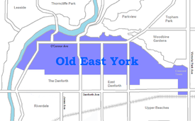 |
|
| Old Mill/Baby Point Baby Point Baby Point is a residential neighbourhood in west end of Toronto, Ontario, Canada. It was formerly in the City of York, and was two independent municipalities prior to that. It is bounded on the west by the Humber River from south of Baby Point Crescent to St. Marks Road, east to Jane Street and... |
0150.00 | 4,010 | 1.07 | 3748 | 1.0 | 110,372 | 16.1 | 10.7 | Ukrainian (4.1%) | ||
| Parkdale Parkdale, Toronto Parkdale is a neighbourhood and former village in Toronto, Ontario, Canada, west of downtown. The neighbourhood is bounded on the west by Roncesvalles Avenue, on the north by Queen Street. It is bounded on the east by Dufferin Street from Queen Street south, and on the south by Lake Ontario... |
0004.00, 0005.00, 0007.01, 0007.02, 0047.01, 0047.02 | 28,367 | 2.03 | 13,974 | -8.0 | 26,314 | 22.2 | 39.0 | Polish (2.9%) | ||
| Parkway Forest Parkway Forest Parkway Forest is a neighbourhood in Toronto, Ontario, Canada. It is located in the north of the city, in the former City of North York. North York was merged with five other municipalities and a regional government to form the new "City of Toronto" in 1998.... |
0301.03, 0301.04 | 8,498 | 1.71 | 4970 | -2.8 | 24,333 | 21.7 | 24.2 | Unspecified Chinese (8.5%) | ||
| Parkwoods | 0270.01, 0270.02, 0271.01, 0271.02, 0272.01, 0272.02 | 26,533 | 4.96 | 5349 | -3.7 | 34,811 | 14.0 | 22.5 | Unspecified Chinese (3.4%) | ||
| Pelmo Park | 0282.00 | 4,402 | 2.2 | 2001 | 14.0 | 32,002 | 9.4 | 3.6 | Italian (6.7%) | ||
| Playter Estates Playter Estates Playter Estates is an area in the east end of Toronto, Canada bounded by Jackman Avenue to the east, the Don River Valley to the west, Danforth Avenue in the south, and Fulton Avenue in the north. The neighbourhood is built on land once owned by the Playter family for whom two streets in the area... |
0085.00 | 3,968 | 0.5 | 7936 | -2.0 | 44,557 | 26.8 | 35.0 | Unspecified Chinese (1.8%) | 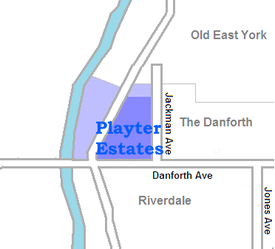 |
|
| Pleasantview | 0302.01, 0302.02, 0302.03 | 16,615 | 3.04 | 5465 | -2.1 | 29,250 | 13.2 | 8.2 | Unspecified Chinese (12.7%) | ||
| Port Lands Port Lands The Port Lands of Toronto, Ontario, Canada are an industrial and recreational neighbourhood located about 5 kilometres south-east of downtown, located on the former Don River delta and most of Ashbridge's Bay.... |
0001.00 | 571 | 6.1 | 94 | -9.0 | 36,243 | 14.9 | 10.5 | Mandarin (3.5%) | 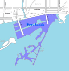 |
|
| Port Union Port Union, Ontario Port Union, also known as Centennial Scarborough is a neighbourhood located in Scarborough, part of Toronto, Ontario, Canada. The neighbourhood is bounded by Kingston Road to the north, Port Union Road to the east, the Lake Ontario shoreline to the south, and Highland Creek to the west.The... |
0361.01, 0361.02 | 12,450 | 5.39 | 2310 | -1.7 | 48,117 | 11.1 | 2.0 | Filipino (1.6%) | ||
| Princess Gardens Princess Gardens Princess Gardens is a neighbourhood in Toronto, Ontario, Canada. It is located in the western area of Toronto that was formerly the City of Etobicoke. Its boundaries are Eglinton Avenue to the north, Martin Grove to the west, Islington to the east, and Rathburn Road to the south. The southeastern... |
0232.00, 0233.00 | 9,288 | 4.13 | 2249 | 1.0 | 80,607 | 7.2 | 5.8 | Korean (2.4%) | ||
| Regal Heights | 0113.00 | 2,719 | 0.38 | 7155 | -8.0 | 36,652 | 24.5 | 19.7 | Spanish (5.5%) | ||
| Regent Park Regent Park Regent Park is a neighbourhood located in Old Toronto, Ontario, Canada. Regent Park is Canada's oldest and largest social housing project; built in the late 1940s. Formerly the centre of the Cabbagetown neighbourhood, it is bounded by Gerrard Street East to the north, River Street to the east,... /Trefann Court Trefann Court Trefann Court is a small neighbourhood in the eastern part of downtown Toronto, Canada. It is located on the north side of Queen Street between Parliament Street and River Street. It extends north only a short distance to Shuter St. In the nineteenth century Trefann Court was considered a part of... |
0030.00, 0031.00 | 10,387 | 0.64 | 16,230 | -7.1 | 19,521 | 16.0 | 31.2 | Bengali (10.5%) | 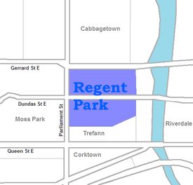 |
|
| Richview Richview, Toronto Richview is a neighbourhood in the city of Toronto, Ontario, Canada. It is located in the former city of Etobicoke. It is bounded on the west by Highway 401 and on the north by the highway and by Dixon Road, Royal York Road on the east, and Eglinton Avenue West along the south... |
0237.01, 0237.02, 0237.03, 0238.01, 0238.02, 0240.01 | 26,053 | 6.51 | 4002 | -4.0 | 34,579 | 10.6 | 16.3 | Italian (4.2%) | ||
| Riverdale Riverdale, Toronto Riverdale is a large neighbourhood in Toronto, Ontario, Canada. It is bounded by the Don River Valley to the west, Danforth Avenue and Greektown to the north, Jones Avenue, the CN/GO tracks, and Leslieville to the east, and Lake Shore Boulevard to the south.... |
0018.00, 0019.00, 0029.00, 0069.00, 0070.00, 0071.00, 0072.01, 0072.02 | 31,007 | 3.99 | 7771 | -5.5 | 40,139 | 20.0 | 17.8 | Cantonese (6.7%) | 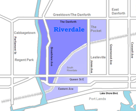 |
|
| Rockcliffe-Smythe Rockcliffe-Smythe Rockcliffe-Smythe is a neighbourhood in Toronto, Canada, north-west of downtown, located in the former City of York. The boundaries, as defined by the city are Eglinton Avenue West to the north from the Humber to Jane Street. It then proceeds south along Jane to Lambton, and follows Lambton past... |
0153.00 | 4,681 | 0.97 | 4826 | -5.0 | 28,723 | 16.3 | 9.0 | Spanish (8.2%) | ||
| Roncesvalles Roncesvalles Roncesvalles is a small village and municipality in Navarre, northern Spain. It is situated on the small river Urrobi at an altitude of some 900 metres in the Pyrenees, about 8 kilometres from the French frontier.... |
0048.00, 0049.00, 0051.00, 0052.00 | 15,996 | 1.98 | 8079 | -4.9 | 46,820 | 21.9 | 22.7 | Polish (4.4%) | ||
| Rosedale Rosedale, Toronto Rosedale is an affluent neighbourhood in Toronto, Ontario, Canada, which was formerly the estate of William Botsford Jarvis, and so named by his wife, granddaughter of William Dummer Powell, for the wild roses that grew there in abundance.... |
0086.00, 0087.00 | 7,672 | 2.72 | 2821 | 4.8 | 213,941 | 11.3 | 11.9 | Unspecified Chinese (1.0%) | ||
| Rouge | 0378.10 | 22,724 | 28.72 | 791 | 175.0 | 29,230 | 12.1 | 2.7 | Tamil (15.6%) | ||
| Rouge Hill | 0362.01, 0362.04 | 11,167 | 3.88 | 2878 | 0.9 | 32,858 | 13.5 | 8.6 | Filipino (2.4%) | ||
| Runnymede Runnymede, Toronto Runnymede is a neighbourhood in Toronto, Ontario, Canada located north of Bloor Street West between Jane Street and Runnymede Road north to Dundas Street West. It is located directly north of the former village of Swansea and west of the High Park North neighbourhood... |
0152.00 | 4,382 | 0.85 | 5155 | -3.0 | 42,635 | 17.3 | 7.1 | Ukrainian (2.2%) | ||
| Scarborough Junction | 0342.00, 0343.00, 0344.01, 0344.02, 0345.00, 0346.01, 0347.00 | 25,780 | 7.41 | 3479 | -3.6 | 25,405 | 18.2 | 15.7 | Tamil (4.2%) | ||
| Scarborough City Centre Scarborough City Centre Scarborough City Centre is the central business district in the Scarborough district of Toronto, Ontario, Canada. It is roughly bounded by Kennedy Road to the west, Markham Road to the east, Ellesmere Road to the south, and Sheppard Avenue to the North... |
0363.06, 0370.01 | 16,403 | 2.58 | 6358 | 22.9 | 26,756 | 14.6 | 15.6 | Tamil (10.3%) | ||
| Scarborough Village Scarborough Village Scarborough Village is a neighbourhood in Toronto, Ontario, Canada, in the south-central part of the district of Scarborough. Historically, it was one of the earliest settlements in the former Township of Scarborough and was the first region of the township to have its own post office... |
0331.03, 0332.00 | 12,796 | 2.03 | 6303 | -9.0 | 24,413 | 16.2 | 22.0 | Tamil (11.4%) | ||
| Seaton Village Seaton Village Seaton Village is a former unincorporated village located west of downtown Toronto, Ontario, Canada. It is named after John Colborne, 1st Baron Seaton, Lieutenant-Governor of Upper Canada from 1828 to 1836. Seaton Village is bordered by Bloor Street to the south, the train tracks to the north,... |
0093.00 | 5,259 | 0.62 | 8482 | -6.0 | 41,506 | 19.1 | 17.3 | Portuguese (5.0%) | 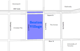 |
|
| Silverthorn Silverthorn, Toronto Silverthorn is a neighbourhood in Toronto, Canada. It covers a central section of the former city of York, Ontario. The approximate boundaries are the CNR lines to the east, Black Creek Drive and Weston Road to the west and the former boundaries of York to the north and south. The area west of... |
0158.00, 0159.01, 0159.02, 0171.00, 0172.00 | 17,757 | 3.52 | 5045 | -3.0 | 26,291 | 15.8 | 16.6 | Portuguese (11.8%) | ||
| Smithfield Smithfield, Toronto Smithfield is part of the Rexdale neighbourhood in the northwestern area of Etobicoke, in the City of Toronto, Ontario, Canada. Some new residents to Toronto and new immigrants to Canada are attracted to this neighbourhood, mainly because there is a large amount of affordable public housing... |
0248.02, 0248.04, 0248.05, 0249.01, 0249.04, 0249.05, 0250.04 | 34,996 | 6.45 | 5426 | -7.2 | 24,387 | 12.8 | 12.7 | Punjabi (11.8%) | ||
| South Hill South Hill, Toronto South Hill is an area of Toronto, Ontario, Canada. It is located north of downtown covering the area west of Avenue Road, south of St. Clair Avenue, east of Spadina Road, and north of the Canadian Pacific railway tracks. The area is dominated by the steep hill of the former Lake Iroquois shoreline... |
0117.00, 0119.00 | 6,218 | 1.26 | 4935 | -3.8 | 120,453 | 16.1 | 29.8 | French (1.0%) | ||
| St. James Town | 0065.00 | 14,666 | 0.23 | 63,765 | -10.0 | 22,341 | 27.4 | 46.2 | Filipino (8.1%) | 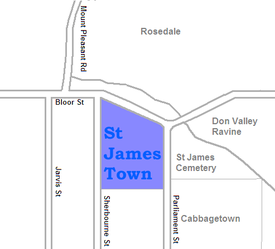 |
|
| Steeles | 0376.04, 0376.05, 0376.09, 0376.13, 0376.14 | 24,696 | 4.52 | 5464 | 1.9 | 26,660 | 10.5 | 5.1 | Cantonese (23.7%) | ||
| Summerhill Summerhill, Toronto The Summerhill neighbourhood in central Toronto was named after 'Summer Hill' house, built in 1842 by Canadian transportation baron Charles Thompson.Much of the area was once part of the Thompson estate but was subdivided by his heirs in the 1880s.... |
0090.00, 0120.00 | 5,100 | 0.65 | 7846 | 3.0 | 88,937 | 17.5 | 24.1 | Unspecified Chinese (1.1%) | ||
| Sunnylea | 0216.00, 0217.00, 0218.00, 0219.00 | 17,602 | 5.23 | 3366 | -1.1 | 51,398 | 13.0 | 17.1 | Polish (5.2%) | ||
| Swansea Swansea, Toronto Swansea is a neighbourhood in the City of Toronto, Ontario, Canada, bounded on the west by the Humber River, on the north by Bloor Street, on the east by High Park and on the south by Lake Ontario... |
0050.01, 0050.02 | 11,133 | 3.76 | 2961 | 0.5 | 58,681 | 18.3 | 12.8 | Polish (3.0%) | ||
| Tam O'Shanter-Sullivan Tam O'Shanter-Sullivan Tam O'Shanter–Sullivan is a neighbourhood in the east end of the city of Toronto, in the district of Scarborough. The neighbourhood is bordered by Huntingwood Drive to the North, Kennedy Road to the East, Highway 401 to the South and Victoria Park to the West... |
0374.01, 0374.02, 0374.03, 0375.02, 0375.03, 0376.07 | 27,235 | 5.44 | 5006 | 3.4 | 27,717 | 12.2 | 15.3 | Unspecified Chinese (12.6%) | ||
| The Annex The Annex The Annex is a neighbourhood in downtown Toronto, Ontario, Canada. The traditional boundaries of the neighbourhood are north to Dupont Street, south to Bloor Street, west to Bathurst Street and east to Avenue Road... |
0091.01, 0091.02, 0092.00 | 15,602 | 1.47 | 10,614 | -2.3 | 63,636 | 22.1 | 41.9 | Spanish (1.3%) | ||
| The Beaches The Beaches The Beaches is a neighbourhood and popular tourist destination located in Toronto, Ontario, Canada. It is located on the east side of the "Old" City of Toronto. The original boundaries of the neighbourhood are from Fallingbrook Avenue on the east to Kingston Road on the north, to Woodbine Avenue... |
0020.00, 0021.00, 0022.00, 0023.00, 0024.00 | 20,416 | 3.57 | 5719 | 7.8 | 67,536 | 13.8 | 16.2 | Cantonese (0.7%) | 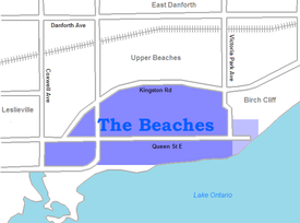 |
|
| The Danforth | 83.00, 84.00 | 7,849 | 0.87 | 9022 | -1.0 | 44,979 | 23.3 | 19.0 | Greek (7.4%) | 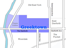 |
|
| The Elms | 0244.01, 0244.02 | 9,437 | 2.86 | 3300 | -3.3 | 28,014 | 12.6 | 13.7 | Spanish (6.1%) | ||
| The Junction The Junction The Junction is a neighbourhood in Toronto, Ontario, Canada, that is near the junction of four railway lines in the area known as the West Toronto Diamond. The neighbourhood was previously an independent city called West Toronto, that was also its own federal electoral district until amalgamating... |
0101.00, 0105.00, 0106.00 | 11,391 | 2.36 | 4827 | 22.8 | 34,906 | 18.0 | 17.0 | Portuguese (4.1%) | ||
| The Kingsway The Kingsway The Kingsway, known also as Kingsway South, is a residential neighbourhood of Toronto, Ontario, Canada. It is located in the former City of Etobicoke, an area that became the west end of Toronto upon amalgamation in 1998. It is bounded by Bloor Street to the south, Dundas Street to the north, the... |
0226.00, 0227.00, 0228.00, 0229.00 | 8,780 | 2.58 | 3403 | 7.9 | 110,944 | 11.8 | 6.2 | Ukrainian (1.8%) | ||
| The Queensway The Queensway The Queensway/Queensway Avenue is a major street in the municipalities of Toronto and Mississauga, Ontario, Canada. It is the western extension of Queen Street, after it merges with King Street near Roncesvalles Avenue in Toronto... |
0215.00 | 6,207 | 2.62 | 2369 | 3.0 | 38,944 | 12.9 | 9.0 | Italian (4.1%) | ||
| Thistletown | 0250.01, 0250.02, 0250.05 | 16,790 | 3.97 | 4229 | 1.4 | 28,955 | 11.2 | 13.7 | Punjabi (8.6%) | ||
| Thorncliffe Park Thorncliffe Park Thorncliffe Park is a densely populated, multicultural neighbourhood in central east Toronto, Ontario, Canada, in the former Borough of East York. East York merged with five other municipalities and a regional government in 1998 to form the new "City of Toronto"... |
0194.01, 0194.02, 0194.03, 0194.04 | 17,949 | 3.09 | 5809 | 9.1 | 25,340 | 16.7 | 32.5 | Urdu (21.5%) | ||
| Toronto Islands Toronto Islands The Toronto Islands are a chain of small islands in the city of Toronto, Ontario. Comprising the only group of islands in the western part of Lake Ontario, the Toronto Islands are located just offshore from the city centre, and provide shelter for Toronto Harbour... |
0002.00 | 627 | 3.17 | 198 | -5.0 | 43,344 | 18.3 | 5.6 | 100% English speaking | ||
| Trinity-Bellwoods | 0040.00, 0043.00 | 8,687 | 0.92 | 9442 | -3.1 | 31,106 | 17.7 | 16.5 | Portuguese (13.6%) | 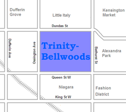 |
|
| Upper Beaches Upper Beaches The Upper Beaches is a rather recently coined name for the neighbourhood directly north of the Beaches area in Toronto, Ontario, Canada. It stretches from Coxwell Avenue in the west to Victoria Park in the east. The southern border is Kingston Road, while the northern boundary is generally... |
0025.00, 0077.00, 0078.00, 0079.00 | 19,830 | 2.92 | 6791 | 0.5 | 44,346 | 18.6 | 17.4 | Cantonese (0.7%) | 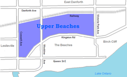 |
|
| Victoria Park Village | 0261.00, 0262.01, 0262.02 | 17,047 | 4.72 | 3612 | 2.5 | 29,657 | 15.6 | 23.4 | Urdu (3.2%) | ||
| Wallace Emerson | 0097.01, 0097.02 | 10,338 | 0.88 | 11,748 | -1.8 | 25,029 | 22.8 | 23.0 | Portuguese (19.2%) | ||
| West Deane Park | 0234.00 | 4,395 | 2.13 | 2063 | 1.0 | 41,582 | 8.3 | 4.9 | Ukrainian (2.3%) | ||
| West Hill West Hill, Toronto -Location and principal features:It is located in the eastern end of the city, in the former city of Scarborough. Scarborough was merged with five other municipalities and a regional government to form the new "City of Toronto" in 1998... |
0358.01, 0358.02, 0358.03, 0359.00, 0360.00 | 25,632 | 9.58 | 2676 | -4.1 | 27,936 | 14.6 | 14.7 | Tamil (3.0%) | ||
| West Rouge West Rouge West Rouge is a small community neighbourhood located in the city of Toronto, Ontario, Canada, within the district of Scarborough. The community is roughly bounded by Lake Ontario to the south, the Rouge River to the east, Highland Creek to the west and Kingston Road to the north.The area was... |
0802.01, 0802.02 | 9,300 | 4.45 | 2090 | -1.8 | 44,605 | 14.1 | 0.8 | Cantonese (2.8%) | ||
| Westminster | 0317.02, 0317.03, 0317.04 | 16,386 | 2.37 | 6914 | 0.8 | 27,826 | 14.6 | 23.4 | Russian (31.4%) | ||
| Westmount | 0240.02 | 5,857 | 1.04 | 5932 | 5.0 | 35,183 | 9.6 | 23.4 | Ukrainian (10.6%) | ||
| Weston Weston, Toronto Weston is a neighbourhood in Toronto, Ontario, Canada in the northwest end of the city, within the former boundaries of the old City of York. The neighbourhood generally lies south of Highway 401, east of the Humber River, north of Eglinton Avenue, and west of Jane Street. Weston Road just north of... |
0175.01, 0175.02, 0176.00 | 16,476 | 2.51 | 6564 | -5.6 | 27,446 | 15.5 | 26.5 | Spanish (7.0%) | ||
| Wexford Wexford, Toronto Wexford is a neighbourhood in Toronto, Ontario, Canada. It is located in the eastern part of the city, on the western end of the district of Scarborough, spanning Lawrence Avenue East between Victoria Park Avenue and Birchmount Road. There are many Greeks in this neighbourhood.The Church of St... |
0349.00, 0350.00, 0371.00 | 17,844 | 7.97 | 2239 | -3.2 | 28,556 | 14.0 | 15.1 | Filipino (4.5%) | ||
| Willowdale Willowdale, Toronto Willowdale is an established, affluent community in the city of Toronto, Ontario, Canada, located in the district of North York. It was originally called Lansing, which is now the name of a nearby neighbourhood.... |
0300.00, 0306.01, 0306.02, 0307.02, 0308.01, 0308.02 | 43,144 | 7.68 | 5618 | 62.3 | 39,895 | 15.6 | 12.9 | Cantonese (7.9%) | ||
| Wilson Heights Clanton Park Clanton Park, sometimes referred to as Dublin Heights or Wilson Heights, is a neighbourhood in the North York area of Toronto, Ontario, Canada. It is part of federal and provincial electoral district York Centre, and Toronto electoral wards 9: York Centre and 10: York Centre... |
0288.00, 0297.02 | 13,732 | 4.14 | 3317 | 1.9 | 37,978 | 15.9 | 18.0 | Filipino (6.2%) | ||
| Woburn Woburn, Toronto Woburn, also known as Cedarbrae, is a neighbourhood located in Toronto, Ontario, Canada, in the district of Scarborough.-Geography:Woburn is bordered by Highway 401 to the north, Scarborough Golf Club Road and Orton Park Road to the east, the CN Railway tracks to the south, and McCowan Road and... |
0356.00, 0357.01, 0357.02, 0363.07, 0364.01, 0364.02, 0365.00, 0366.00, 0367.01 | 48,507 | 13.34 | 3636 | -1.5 | 26,190 | 13.3 | 16.0 | Gujarati (9.1%) | 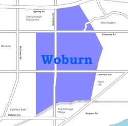 |
|
| Wychwood Wychwood The Wychwood, or Wychwood Forest, is an area now covering a small part of rural Oxfordshire. In past centuries the forest covered a much larger area, since cleared in favour of agriculture, villages and towns. However, the forest's area has fluctuated... |
0116.00 | 4,182 | 0.68 | 6150 | -2.0 | 53,613 | 17.1 | 20.1 | Portuguese (2.7%) | ||
| York Mills York Mills York Mills is the name of an affluent neighbourhood around Yonge Street and York Mills Road located in the district of North York in the city of Toronto, Ontario, Canada.... |
0273.01, 0273.02, 0274.01, 0274.02 | 17,564 | 7.29 | 2409 | 2.0 | 92,099 | 10.0 | 11.8 | Korean (4.0%) | ||
| York University Heights York University Heights York University Heights, also known as Northwood Park, is one of the northernmost neighbourhoods in the city of Toronto, Ontario. The name of the neighbourhood is because it contains the main campus of York University. This area is most popular with immigrants of Italian and Chinese descent who... |
0311.02, 0311.03, 0311.04, 0311.05, 0311.06 | 26,140 | 13.21 | 1979 | -1.2 | 24,432 | 15.2 | 20.4 | Italian (6.6%) | ||
| Yorkville Yorkville, Toronto Yorkville is a district in Toronto, Ontario, Canada, well known for its shopping. It is a former village, annexed by the City of Toronto. It is roughly bounded by Bloor Street to the south, Davenport Road to the north, Yonge Street to the east and Avenue Road to the west, and is considered part of... |
0088.00, 0089.00 | 6,045 | 0.56 | 10,795 | 62.6 | 105,239 | 18.3 | 27.9 | French (1.9%) |
City designated neighbourhoods
For administrative purposes the City of Toronto divides the city into 140 neighbourhoods. These divisions are used for internal planning purposes. The boundaries and names often do not conform to the usage of the general population or designated business improvement areas. A number of neighbourhood maps of Toronto do exist, some produced by real estate firms and some by Internet portals. A project to map the neighbourhoods according to the common usage of the residents was done by the Toronto StarToronto Star
The Toronto Star is Canada's highest-circulation newspaper, based in Toronto, Ontario, Canada. Its print edition is distributed almost entirely within the province of Ontario...
newspaper. Based on feedback from Star readers, it has produced the most comprehensive, albeit informal, neighbourhood map.
| CDN number | City designated area | Former city | Neighbourhoods covered | Map |
|---|---|---|---|---|
| 129 | Agincourt North | Scarborough | Agincourt Agincourt, Toronto Agincourt is a very diverse neighbourhood in the Scarborough district of the city of Toronto, Ontario, Canada. It is centred along Sheppard Avenue between Kennedy and Markham Roads... and Brimwood |
|
| 128 | Agincourt South-Malvern West | Scarborough | Agincourt Agincourt, Toronto Agincourt is a very diverse neighbourhood in the Scarborough district of the city of Toronto, Ontario, Canada. It is centred along Sheppard Avenue between Kennedy and Markham Roads... and Malvern Malvern, Toronto Malvern is a neighbourhood in Toronto, Ontario, Canada, with a population of 44,315. It is located in the northeast corner of the city, in the district of Scarborough. Scarborough was merged with five other municipalities and a regional government to form the new City of Toronto in 1998... |
|
| 020 | Alderwood | Etobicoke | Alderwood Alderwood, Toronto Alderwood is a neighbourhood in the city of Toronto, Ontario, Canada. It is in the western section of Toronto, formerly the city of Etobicoke. It is bounded by the Etobicoke Creek to the west, the Gardiner Expressway to the north, the CPR railway to the east and the CNR railway to the... |
 |
| 095 | Annex | Old City of Toronto | The Annex The Annex The Annex is a neighbourhood in downtown Toronto, Ontario, Canada. The traditional boundaries of the neighbourhood are north to Dupont Street, south to Bloor Street, west to Bathurst Street and east to Avenue Road... and Seaton Village Seaton Village Seaton Village is a former unincorporated village located west of downtown Toronto, Ontario, Canada. It is named after John Colborne, 1st Baron Seaton, Lieutenant-Governor of Upper Canada from 1828 to 1836. Seaton Village is bordered by Bloor Street to the south, the train tracks to the north,... |
 |
| 042 | Banbury-Don Mills | North York | Don Mills Don Mills Don Mills is a mixed-use neighbourhood in the North York district of Toronto, Canada. It was developed to be a self-supporting "new town" and was at the time located outside of Toronto proper. Consisting of residential, commercial and industrial sub-districts, it was planned and developed by... |
|
| 034 | Bathurst Manor | North York | Bathurst Manor Bathurst Manor Bathurst Manor is a neighbourhood located in the North York district of Toronto, Ontario, Canada. It sits on a plateau bounded on the north by Finch Avenue West, on the west by Dufferin Street, on the east by the Don River , and on the south by Sheppard Avenue West. The area is also regarded as... |
|
| 076 | Bay Street Corridor | Old City of Toronto | Bay Street Bay Street Bay Street, originally known as Bear Street, is a major thoroughfare in Downtown Toronto. It is the centre of Toronto's Financial District and is often used by metonymy to refer to Canada's financial industry since succeeding Montreal's St. James Street in that role in the 1970s... , Financial District Financial District, Toronto The Financial District is a business district in Toronto, Ontario, Canada, within the downtown core. It was originally planned as New Town in 1796 as an extension of the Town of York . It is the main financial district in Toronto, and is the financial heart of Canada... |
|
| 052 | Bayview Village | North York | Bayview Village Bayview Village Bayview Village is an affluent neighbourhood in Toronto, Ontario, Canada, formerly in North York before it was amalgamated into Toronto in 1998. It is part of the federal and provincial electoral district Willowdale, and Toronto electoral wards 24: Willowdale and 33: Don Valley North... |
|
| 049 | Bayview Woods-Steeles | North York | Bayview Woods | |
| 039 | Bedford Park-Nortown | North York | Bedford Park Bedford Park, Toronto Bedford Park began as a farming hamlet north of Toronto. The hamlet was a popular stopover for farmers making their way to market in the city. The neighbourhood was likely named after the Bedford Park Hotel, which opened in 1873 at the southwest corner of Yonge Street and Fairlawn Avenue, just... , Ledbury Park, and Nortown |
 |
| 112 | Beechborough-Greenbrook | York | Keelesdale and Silverthorn Silverthorn, Toronto Silverthorn is a neighbourhood in Toronto, Canada. It covers a central section of the former city of York, Ontario. The approximate boundaries are the CNR lines to the east, Black Creek Drive and Weston Road to the west and the former boundaries of York to the north and south. The area west of... |
 |
| 127 | Bendale | Scarborough | Bendale Bendale Bendale, also called Cedarbrae, is a neighbourhood in the eastern part of Toronto, Ontario, Canada, in Scarborough. The area is ethnically diverse, like much of Toronto, but has a greater proportion of South Asian population, especially Tamils.... |
|
| 122 | Birchcliffe-Cliffside | Scarborough | Birch Cliff Birch Cliff Birch Cliff is a neighbourhood in Toronto, Canada. It is located in the southwest part of the old city of Scarborough running along shore of Lake Ontario atop the eastern part of the Scarborough Bluffs. The area was first developed as the home of the Toronto Hunt Club in 1895 when the region was... and Cliffside |
|
| 024 | Black Creek | North York | Jane and Finch Jane and Finch Jane and Finch is a neighbourhood located in northwestern North York, a district of Toronto, Ontario, Canada. The area is roughly bounded by Highway 400 to the west, Driftwood Avenue to the east, Grandravine Drive to the south, and Shoreham Drive to the north... |
|
| 069 | Blake-Jones | Old City of Toronto | The Pocket and Riverdale Riverdale, Toronto Riverdale is a large neighbourhood in Toronto, Ontario, Canada. It is bounded by the Don River Valley to the west, Danforth Avenue and Greektown to the north, Jones Avenue, the CN/GO tracks, and Leslieville to the east, and Lake Shore Boulevard to the south.... |
 |
| 108 | Briar Hill-Belgravia | York | Fairbank Fairbank, Toronto Fairbank is a neighbourhood located in the city of Toronto. It covers a large central portion of the former city of York, Ontario centered on the intersection of Dufferin Street and Eglinton Avenue. The western border is the CNR lines... |
 |
| 041 | Bridle Path-Sunnybrook-York Mills | North York | The Bridle Path Bridle Path, Toronto The Bridle Path upscale residential neighbourhood in the former city of North York, now part of Toronto, Ontario, Canada, that is characterized by large multi-million dollar mansions and two to four acre lot sizes. It is often referred to as "Millionaires' Row"... and York Mills York Mills York Mills is the name of an affluent neighbourhood around Yonge Street and York Mills Road located in the district of North York in the city of Toronto, Ontario, Canada.... |
|
| 057 | Broadview North | East York | Old East York Old East York Old East York is a neighbourhood in the city of Toronto located in the former East York. While East York was a much larger area, the name has been kept as a reminder to the days before the mega city. There are multiple definitions of its extent, but at its largest Old East York has covers the... |
|
| 030 | Brookhaven-Amesbury | North York | Amesbury Amesbury, Toronto Amesbury is a neighbourhood in Toronto, Ontario, Canada, formerly in North York before it was amalgamated into Toronto in 1998. It is part of federal and provincial electoral district York South—Weston, and Toronto electoral wards 11: York South—Weston and 12: York South-Weston .Its borders are... |
|
| 071 | Cabbagetown-South St. James Town | Old City of Toronto | Cabbagetown Cabbagetown, Toronto Cabbagetown is a neighbourhood located on the east side of downtown Toronto, Ontario, Canada. It comprises "the largest continuous area of preserved Victorian housing in all of North America", according to the Cabbagetown Preservation Association.... and St. James Town |
|
| 109 | Caledonia-Fairbank | York | Fairbank Fairbank, Toronto Fairbank is a neighbourhood located in the city of Toronto. It covers a large central portion of the former city of York, Ontario centered on the intersection of Dufferin Street and Eglinton Avenue. The western border is the CNR lines... and Cedarvale |
|
| 096 | Casa Loma | Old City of Toronto | Casa Loma, and Wychwood |  |
| 133 | Centennial Scarborough | Scarborough | Port Union Port Union, Ontario Port Union, also known as Centennial Scarborough is a neighbourhood located in Scarborough, part of Toronto, Ontario, Canada. The neighbourhood is bounded by Kingston Road to the north, Port Union Road to the east, the Lake Ontario shoreline to the south, and Highland Creek to the west.The... and Centennial |
|
| 075 | Church-Yonge Corridor | Old City of Toronto | Church and Wellesley Church and Wellesley Church and Wellesley is an LGBT-oriented community located in Toronto, Ontario, Canada. It is roughly bounded by Gerrard Street to the south, Yonge Street to the west, Charles Street to the north, and Jarvis Street to the east, with the core commercial strip located along Church Street from... and Ryerson University Ryerson University Ryerson University is a public research university located in downtown Toronto, Ontario, Canada. Its urban campus is adjacent to Yonge-Dundas Square located at the busiest intersection in Downtown Toronto. The majority of its buildings are in the blocks northeast of the square in Toronto's Garden... |
|
| 120 | Clairlea-Birchmount | Scarborough | Clairlea | |
| 033 | Clanton Park | North York | Wilson Heights Clanton Park Clanton Park, sometimes referred to as Dublin Heights or Wilson Heights, is a neighbourhood in the North York area of Toronto, Ontario, Canada. It is part of federal and provincial electoral district York Centre, and Toronto electoral wards 9: York Centre and 10: York Centre... |
 |
| 123 | Cliffcrest | Scarborough | Cliffside | |
| 092 | Corso Italia-Davenport | Old City of Toronto | Corso Italia, Earlscourt, and Regal Heights |  |
| 061 | Crescent Town | East York | Crescent Town | |
| 059 | Danforth Village - East York | East York | Old East York Old East York Old East York is a neighbourhood in the city of Toronto located in the former East York. While East York was a much larger area, the name has been kept as a reminder to the days before the mega city. There are multiple definitions of its extent, but at its largest Old East York has covers the... , The Danforth |
|
| 066 | Danforth Village - Toronto | Old City of Toronto | The Danforth | |
| 047 | Don Valley Village | North York | Don Valley Village Don Valley Village Don Valley Village is a neighbourhood in the city of Toronto, Ontario, Canada. It is located north of Highway 401, and is bounded by Sheppard Avenue to the south, Leslie Street to the west, Finch Avenue to the north and Highway 404 to the east... , The Peanut |
|
| 126 | Dorset Park | Scarborough | Dorset Park Dorset Park Dorset Park is a neighbourhood in Scarborough, a district of the city of Toronto, Ontario, Canada. The neighbourhood is located in western Scarborough, bordered by Highway 401 to the North, Midland Avenue to the East, Lawrence Avenue to the South, Birchmount Road to the west, and Kennedy Road... |
|
| 093 | Dovercourt-Wallace Emerson-Junction | Old City of Toronto | Dovercourt Park, Wallace Emerson and Davenport |  |
| 026 | Downsview-Roding-CFB | North York | Downsview | 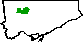 |
| 083 | Dufferin Grove | Old City of Toronto | Brockton Brockton Village Brockton Village is a neighbourhood in Toronto, Ontario, Canada. It comprises a section of the old Town of Brockton which was annexed by the City of Toronto in 1884. The town encompassed the area from Bloor Street on the north, Dufferin Street on the east, High Park on the west and ranged from... and Dufferin Grove Dufferin Grove Dufferin Grove is a neighbourhood located in Toronto, Ontario, Canada, west of downtown. The neighbourhood is bordered by Bloor Street West to the north, Ossington Ave to the east, College Street to the south, and Dufferin Street to the west.-Character:... |
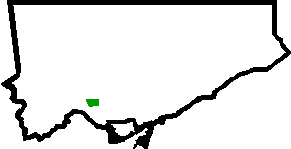 |
| 062 | East End-Danforth | Old City of Toronto | Upper Beaches Upper Beaches The Upper Beaches is a rather recently coined name for the neighbourhood directly north of the Beaches area in Toronto, Ontario, Canada. It stretches from Coxwell Avenue in the west to Victoria Park in the east. The southern border is Kingston Road, while the northern boundary is generally... , East Danforth East Danforth East Danforth is a neighbourhood in Toronto, Canada. It is located on the eastern part of Danforth Avenue in the old city of Toronto. It stretches from the eastern edge of Greektown by Jones Avenue to the boundary of Scarborough at Victoria Park Avenue. The area is covered by two business... |
|
| 009 | Edenbridge-Humber Valley | Etobicoke | Humber Valley Humber Valley The Humber Valley is a region in the western part of the island of Newfoundland. The Humber Valley is formed by the Humber River.The upper part of the valley follows the Upper Humber River and contains the communities of Reidville and Cormack.After the river discharges into Deer Lake, the valley... |
|
| 128 | Eglinton East | Scarborough | Eglinton East | 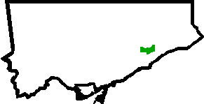 |
| 005 | Elms-Old Rexdale | Etobicoke | The Elms and Rexdale Rexdale Rexdale is a neighbourhood located in the north-west corner of Toronto, Ontario, Canada. It covers the northern section of Etobicoke, which was an independent city until it merged with five other municipalities and a regional government to form the new City of Toronto in 1998. Rexdale was named... |
|
| 032 | Englemount-Lawrence | North York | Lawrence Manor Lawrence Manor Lawrence Manor is a neighbourhood in the city of Toronto, Ontario, Canada. The neighbourhood is bounded by Bathurst Street on the east, Highway 401 to the north, the Allen to the west, and Lawrence Avenue to the south... and Glen Park Glen Park, Toronto Glen Park is a neighbourhood in the city of Toronto, Ontario, Canada, located in the district of North York. It is bounded by Lawrence Avenue to the north, Bathurst Street to the east, a line south of Stayner Avenue to the south, and the CNR tracks to the west. Prior to the amalgamation of... |
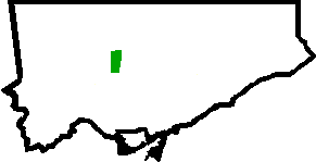 |
| 011 | Eringate-Centennial-West Deane | Etobicoke | Centennial Park Centennial Park (Toronto) Centennial Park is a large regional park located in westend Toronto, in the former city of Etobicoke. It is maintained by the City of Toronto Parks and Recreation.The park has a variety of features including:*Centennial Park Conservatory... and West Deane Park |
|
| 013 | Etobicoke West Mall | Etobicoke | Centennial Park Centennial Park (Toronto) Centennial Park is a large regional park located in westend Toronto, in the former city of Etobicoke. It is maintained by the City of Toronto Parks and Recreation.The park has a variety of features including:*Centennial Park Conservatory... and Eatonville Eatonville, Toronto Eatonville is a neighbourhood in the Etobicoke community of the city of Toronto, Ontario, Canada. Located west of the area known as Islington, Eatonville is bisected by Highway 427, with the community generally located north of Dundas Street West and south of Rathburn Road... |
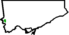 |
| 044 | Flemingdon Park | North York | Flemingdon Park Flemingdon Park Flemingdon Park is a multicultural community in Toronto, Ontario, Canada, located in the North York district of the city. It is part of federal and provincial electoral district Don Valley West, and Toronto electoral ward 26: Don Valley West... |
|
| 102 | Forest Hill North | Old City of Toronto | Forest Hill Forest Hill, Toronto Forest Hill is an affluent neighbourhood in central Toronto, Ontario, Canada. Along with Lawrence Park, Rosedale, and The Bridle Path, it is one of Toronto’s wealthiest neighbourhoods.-History:... |
|
| 101 | Forest Hill South | Old City of Toronto | Forest Hill Forest Hill, Toronto Forest Hill is an affluent neighbourhood in central Toronto, Ontario, Canada. Along with Lawrence Park, Rosedale, and The Bridle Path, it is one of Toronto’s wealthiest neighbourhoods.-History:... |
|
| 025 | Glenfield-Jane Heights | North York | Jane and Finch Jane and Finch Jane and Finch is a neighbourhood located in northwestern North York, a district of Toronto, Ontario, Canada. The area is roughly bounded by Highway 400 to the west, Driftwood Avenue to the east, Grandravine Drive to the south, and Shoreham Drive to the north... |
|
| 065 | Greenwood-Coxwell | Old City of Toronto | Leslieville Leslieville Leslieville is a neighbourhood in Toronto, Ontario, Canada east of the Don River bounded by the Canadian National railway line and Gerrard Street to the north, Empire Avenue to the west, Eastern Avenue to south, and Coxwell Avenue to the east.-History:... |
|
| 140 | Guildwood | Scarborough | Guildwood Guildwood Guildwood, also known as Guildwood Village, is a historic and residential neighbourhood in Scarborough, Toronto, Ontario, Canada. It is located along the Scarborough Bluffs, south of Kingston Road, from Grey Abbey Trail in the east to the end of Sylvan Avenue in the west.-History:Guildwood village... |
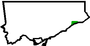 |
| 053 | Henry Farm | North York | Henry Farm Henry Farm Henry Farm is an officially designated neighbourhood in the City of Toronto, Ontario, Canada. It is located in the north central part of town within the district of North York.... |
|
| 088 | High Park North High Park North High Park North, or often, simply 'High Park', after the park, is a neighbourhood in Toronto, Ontario, Canada. It is bounded on the south by Bloor Street, on the west by Runnymede Road, on the north by Annette Street, Quebec Avenue and Humberside Avenue, and on the east by the CNR/CPR railway... |
Old City of Toronto | High Park North, West Bend |  |
| 087 | High Park-Swansea | Old City of Toronto | High Park, Roncesvalles and Swansea Swansea, Toronto Swansea is a neighbourhood in the City of Toronto, Ontario, Canada, bounded on the west by the Humber River, on the north by Bloor Street, on the east by High Park and on the south by Lake Ontario... |
|
| 134 | Highland Creek | Scarborough | Highland Creek Highland Creek, Toronto Highland Creek is a neighbourhood in south-east Scarborough in Toronto, Ontario, Canada that lies along the southern portion of the river of the same name... |
|
| 048 | Hillcrest Village | North York | Hillcrest Village Hillcrest Village Hillcrest Village is a neighbourhood located in the district of North York at the northernmost tip of the city of Toronto, Ontario, Canada. Hillcrest Village is considered by some to be part of the Don Valley Village, the neighbourhood directly to the south, however it is quite distinct... |
|
| 008 | Humber Heights-Westmount | Etobicoke | Humber Heights-Westmount Humber Heights-Westmount Humber Heights-Westmount, also known as Humbervale, is a neighbourhood in Etobicoke, Toronto, Ontario. The neighbourhood is bounded by the west bank of the Humber River, west to Royal York Road and south to Eglinton Avenue West... |
|
| 021 | Humber Summit | North York | Humber Summit Humber Summit Humber Summit is one of the northernmost neighbourhoods in Toronto, Ontario, located in the North York district of the city. It is bounded by Steeles Avenue to the north, Highway 400 to the east, Finch Avenue to the south, and follows the Humber River to the west.-Character:In the 1840s, Humber... |
|
| 022 | Humbermede | North York | Humbermede Humbermede Humbermede, often called Emery, is a neighbourhood of Toronto, Ontario, Canada. Humbermede, like many of the "Humber" neighbourhoods in the city, gets its name from the Humber River... and Emery |
|
| 106 | Humewood-Cedarvale | York | Cedarvale and Humewood |  |
| 125 | Ionview | Scarborough | Ionview Ionview Ionview is a neighbourhood in Toronto, Ontario, in the district of Scarborough. It is bounded by Birchmount Road to the west, the hydro transmission corridor north of Ranstone Gardens to the north, the CNR railway to the east, and Eglinton Avenue East, Kennedy Road and the CNR railway to the south... |
 |
| 014 | Islington-City Centre West | Etobicoke | Islington – Six Points | 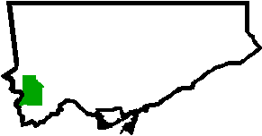 |
| 090 | Junction Area | Old City of Toronto | The Junction The Junction The Junction is a neighbourhood in Toronto, Ontario, Canada, that is near the junction of four railway lines in the area known as the West Toronto Diamond. The neighbourhood was previously an independent city called West Toronto, that was also its own federal electoral district until amalgamating... |
 |
| 110 | Keelesdale-Eglinton West | York | Keelesdale and Silverthorn Silverthorn, Toronto Silverthorn is a neighbourhood in Toronto, Canada. It covers a central section of the former city of York, Ontario. The approximate boundaries are the CNR lines to the east, Black Creek Drive and Weston Road to the west and the former boundaries of York to the north and south. The area west of... |
 |
| 124 | Kennedy Park | Scarborough | Scarborough Junction | |
| 078 | Kensington-Chinatown | Old City of Toronto | Alexandra Park, Chinatown Chinatown, Toronto Chinatown is an ethnic enclave in Downtown Toronto, Ontario, Canada, with a high concentration of ethnic Chinese residents and businesses extending along Dundas Street West and Spadina Avenue. First developed in the late 19th century, it is now one of the largest Chinatowns in North America and... , Grange Park Grange Park (neighbourhood) Grange Park is a neighbourhood in downtown Toronto, Ontario, Canada. It is bounded on the west by Spadina Avenue, on the north by College Street, on the east by University Avenue and on the south by Queen Street. It is within the 'Kensington-Chinatown' City of Toronto planning neighbourhood. Its... , Kensington Market Kensington Market Kensington Market is a distinctive multicultural neighbourhood in Downtown Toronto, Ontario, Canada. The Market is an older neighbourhood and one of the city's most well-known. In November 2006, it was designated a National Historic Site of Canada. Robert Fulford wrote in 1999 that "Kensington... |
|
| 006 | Kingsview Village-The Westway | Etobicoke | Kingsview Village and Richview Richview, Toronto Richview is a neighbourhood in the city of Toronto, Ontario, Canada. It is located in the former city of Etobicoke. It is bounded on the west by Highway 401 and on the north by the highway and by Dixon Road, Royal York Road on the east, and Eglinton Avenue West along the south... |
 |
| 015 | Kingsway South | Etobicoke | The Kingsway The Kingsway The Kingsway, known also as Kingsway South, is a residential neighbourhood of Toronto, Ontario, Canada. It is located in the former City of Etobicoke, an area that became the west end of Toronto upon amalgamation in 1998. It is bounded by Bloor Street to the south, Dundas Street to the north, the... |
|
| 117 | L'Amoreaux | Scarborough | L'Amoreaux L'Amoreaux L'Amoreaux is a neighbourhood in Toronto, Ontario, Canada, situated east of Victoria Park Avenue, south of McNicoll Avenue, west of Kennedy Road and north of Huntingwood Drive. L'Amoreaux is named after Josue L'Amoreaux , a French Huguenot loyalist who settled in the area... , Leacock, and Bridlewood |
|
| 114 | Lambton Baby Point | York | Baby Point Baby Point Baby Point is a residential neighbourhood in west end of Toronto, Ontario, Canada. It was formerly in the City of York, and was two independent municipalities prior to that. It is bounded on the west by the Humber River from south of Baby Point Crescent to St. Marks Road, east to Jane Street and... and Old Mill |
 |
| 038 | Lansing-Westgate | North York | Lansing | |
| 105 | Lawrence Park North | Old City of Toronto | Bedford Park Bedford Park, Toronto Bedford Park began as a farming hamlet north of Toronto. The hamlet was a popular stopover for farmers making their way to market in the city. The neighbourhood was likely named after the Bedford Park Hotel, which opened in 1873 at the southwest corner of Yonge Street and Fairlawn Avenue, just... , Teddington Park, and Wanless Park Wanless Park Wanless Park is a neighbourhood and park in North Toronto. It is located just north of Lawrence Avenue, between Bayview Avenue and Yonge Street.Central to the Wanless Park neighbourhood is a public park called Wanless Park... |
|
| 103 | Lawrence Park South | Old City of Toronto | Lawrence Park Lawrence Park, Toronto Lawrence Park is one of Toronto, Canada's most affluent residential neighbourhoods, along with Rosedale, the Bridle Path, and Forest Hill. It is also one of the wealthiest neighbourhoods in Canada.... , Lytton Park, North Toronto North Toronto North Toronto was a town located in the northern part of the Old Toronto district in Toronto, Ontario, Canada. It occupies a geographically central location within the current boundaries of the city of Toronto. It is a relatively narrow strip, centred around Yonge Street; it extends from the CP... |
|
| 056 | Leaside-Bennington | East York | Leaside Leaside Leaside is a neighbourhood in Toronto, Ontario, Canada. The area takes its name from William Lea and the Lea family, who settled there in the early years of the nineteenth century. The area first developed as farmland along with Toronto through the nineteenth century. It was incorporated as a... |
|
| 084 | Little Portugal | Old City of Toronto | Little Portugal Little Portugal, Toronto Little Portugal is a neighbourhood and ethnic enclave in Toronto, Ontario, Canada. It is located west of downtown in the "Old" City of Toronto. It is bounded on the west by Lansdowne Avenue, on the north by College Street, on the east by Ossington Avenue and on the south by the CNR/CPR mainline... and Brockton Brockton Village Brockton Village is a neighbourhood in Toronto, Ontario, Canada. It comprises a section of the old Town of Brockton which was annexed by the City of Toronto in 1884. The town encompassed the area from Bloor Street on the north, Dufferin Street on the east, High Park on the west and ranged from... |
|
| 019 | Long Branch | Etobicoke | Long Branch Long Branch, Toronto The former Village of Long Branch is a neighbourhood in the south-west of Toronto, Ontario, Canada. It is located in the south-west corner of the former Township of Etobicoke and was a partially-independent municipality from 1930-1967... |
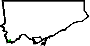 |
| 132 | Malvern | Scarborough | Malvern Malvern, Toronto Malvern is a neighbourhood in Toronto, Ontario, Canada, with a population of 44,315. It is located in the northeast corner of the city, in the district of Scarborough. Scarborough was merged with five other municipalities and a regional government to form the new City of Toronto in 1998... |
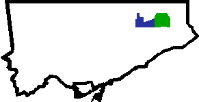 |
| 029 | Maple Leaf | North York | Downsview | |
| 012 | Markland Wood | Etobicoke | Markland Wood Markland Wood Markland Wood is a residential neighbourhood located in Etobicoke, in the City of Toronto, Ontario, Canada. It is bounded by Etobicoke Creek to the west, Elmcrest Creek to the east and surrounded by the Markland Wood Country Club... |
|
| 130 | Milliken | Scarborough | Milliken Milliken, Ontario Milliken or Milliken Mills is a neighbourhood in the city of Toronto and Markham, Ontario. It is located in the North East section of Scarborough and South East section of Markham... |
|
| 017 | Mimico | Etobicoke | Mimico Mimico The historic Town of Mimico is a neighbourhood in the south-western part of Toronto, Ontario, Canada. It is located in the south-east corner of the former Township of Etobicoke, and was an independent municipality from 1911 to 1967.... |
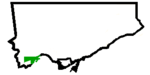 |
| 135 | Morningside | Scarborough | Morningside | |
| 073 | Moss Park | Old City of Toronto | Moss Park, Corktown Corktown, Toronto Corktown is a residential neighbourhood in downtown Toronto, Ontario, Canada. It is just south of Regent Park and north of the Gardiner Expressway, between Berkeley Street to the west and the Don River to the east, Shuter Street to Lake Shore Boulevard East, this area also includes the Distillery... and Garden District |
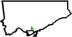 |
| 115 | Mount Dennis | York | Mount Dennis Mount Dennis Mount Dennis is a neighbourhood in Toronto, Ontario, Canada, bordered by the intersection of Jane Street and Weston Road to the north, and Black Creek to the east and south, as the creek curves parallel to Alliance Avenue before crossing under Jane Street on its way to drain into the Humber River,... |
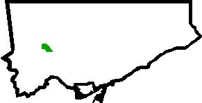 |
| 002 | Mount Olive-Silverstone-Jamestown | Etobicoke | Smithfield Smithfield, Toronto Smithfield is part of the Rexdale neighbourhood in the northwestern area of Etobicoke, in the City of Toronto, Ontario, Canada. Some new residents to Toronto and new immigrants to Canada are attracted to this neighbourhood, mainly because there is a large amount of affordable public housing... |
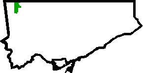 |
| 099 | Mount Pleasant East | Old City of Toronto | Davisville Village, North Toronto North Toronto North Toronto was a town located in the northern part of the Old Toronto district in Toronto, Ontario, Canada. It occupies a geographically central location within the current boundaries of the city of Toronto. It is a relatively narrow strip, centred around Yonge Street; it extends from the CP... |
|
| 104 | Mount Pleasant West | Old City of Toronto | Davisville Village, North Toronto North Toronto North Toronto was a town located in the northern part of the Old Toronto district in Toronto, Ontario, Canada. It occupies a geographically central location within the current boundaries of the city of Toronto. It is a relatively narrow strip, centred around Yonge Street; it extends from the CP... |
|
| 018 | New Toronto | Etobicoke | New Toronto New Toronto The historic Town of New Toronto is a neighbourhood in the south-west end of Toronto, Ontario, Canada. It is located in the south-centre of the former Township of Etobicoke and was an independent municipality from 1913 to 1967, one of the former 'Lakeshore Municipalities'... |
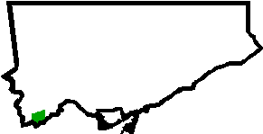 |
| 050 | Newtonbrook East | North York | Newtonbrook | |
| 036 | Newtonbrook West | North York | Newtonbrook | |
| 082 | Niagara | Old City of Toronto | Niagara, Liberty Village Liberty Village Liberty Village is a neighbourhood in Toronto, Ontario, Canada. It is bounded at the north by King Street West, the west by Dufferin Street, the south by the Gardiner Expressway, the east by Strachan Avenue, and the northeast by the CP railway tracks... , Exhibition Place Exhibition Place Exhibition Place is a mixed-use district in Toronto, Ontario, Canada, by the shoreline of Lake Ontario, just west of downtown. The 197–acre area includes expo, trade, and banquet centres, theatre and music buildings, monuments, parkland, sports facilities, and a number of civic, provincial,... |
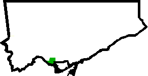 |
| 068 | North Riverdale | Old City of Toronto | Riverdale Riverdale, Toronto Riverdale is a large neighbourhood in Toronto, Ontario, Canada. It is bounded by the Don River Valley to the west, Danforth Avenue and Greektown to the north, Jones Avenue, the CN/GO tracks, and Leslieville to the east, and Lake Shore Boulevard to the south.... |
|
| 074 | North St. James Town | Old City of Toronto | St. James Town | |
| 054 | O'Connor-Parkview O'Connor-Parkview O'Connor–Parkview is a neighbourhood in the East York area of Toronto, Ontario, Canada. While the name is taken from the definition used by the city of Toronto, local residents are more familiar with the niche areas that define the larger neighbourhood. It is a very diverse neighbourhood that... |
East York | Parkview Hills, Topham Park | |
| 121 | Oakridge | Scarborough | Oakridge | |
| 107 | Oakwood-Vaughan | York | Oakwood, Fairbank Fairbank, Toronto Fairbank is a neighbourhood located in the city of Toronto. It covers a large central portion of the former city of York, Ontario centered on the intersection of Dufferin Street and Eglinton Avenue. The western border is the CNR lines... , Cedarvale |
 |
| 058 | Old East York | East York | Old East York Old East York Old East York is a neighbourhood in the city of Toronto located in the former East York. While East York was a much larger area, the name has been kept as a reminder to the days before the mega city. There are multiple definitions of its extent, but at its largest Old East York has covers the... |
|
| 080 | Palmerston-Little Italy | Old City of Toronto | Little Italy Little Italy, Toronto Little Italy, sometimes referred to as College Street West, is a district in Toronto, Ontario, Canada. It is well known for its numerous Italian Canadian restaurants and businesses. There is also a significant Latin American and Portuguese community in the area... |
|
| 085 | Parkdale | Old City of Toronto | Parkdale Parkdale, Toronto Parkdale is a neighbourhood and former village in Toronto, Ontario, Canada, west of downtown. The neighbourhood is bounded on the west by Roncesvalles Avenue, on the north by Queen Street. It is bounded on the east by Dufferin Street from Queen Street south, and on the south by Lake Ontario... , South Parkdale |
|
| 045 | Parkwoods-Donalda | North York | Parkwoods | |
| 023 | Pelmo Park-Humberlea | North York | Weston Weston, Toronto Weston is a neighbourhood in Toronto, Ontario, Canada in the northwest end of the city, within the former boundaries of the old City of York. The neighbourhood generally lies south of Highway 401, east of the Humber River, north of Eglinton Avenue, and west of Jane Street. Weston Road just north of... and Humberlea |
 |
| 067 | Playter Estates-Danforth | Old City of Toronto | Playter Estates Playter Estates Playter Estates is an area in the east end of Toronto, Canada bounded by Jackman Avenue to the east, the Don River Valley to the west, Danforth Avenue in the south, and Fulton Avenue in the north. The neighbourhood is built on land once owned by the Playter family for whom two streets in the area... and Greektown |
|
| 046 | Pleasant View | North York | Pleasant View | |
| 010 | Princess-Rosethorn | Etobicoke | Princess Anne Manor, Thorncrest Village Thorncrest Village Thorncrest Village is a neighbourhood in northwestern Toronto. It is a collection of tree-lined streets north of Rathburn Road, between Kipling and Islington avenues, in what used to be part of Etobicoke.... , and Princess Margaret |
|
| 072 | Regent Park Regent Park Regent Park is a neighbourhood located in Old Toronto, Ontario, Canada. Regent Park is Canada's oldest and largest social housing project; built in the late 1940s. Formerly the centre of the Cabbagetown neighbourhood, it is bounded by Gerrard Street East to the north, River Street to the east,... |
Old City of Toronto | Regent Park, Trefann Court Trefann Court Trefann Court is a small neighbourhood in the eastern part of downtown Toronto, Canada. It is located on the north side of Queen Street between Parliament Street and River Street. It extends north only a short distance to Shuter St. In the nineteenth century Trefann Court was considered a part of... |
 |
| 004 | Rexdale-Kipling | Etobicoke | Rexdale Rexdale Rexdale is a neighbourhood located in the north-west corner of Toronto, Ontario, Canada. It covers the northern section of Etobicoke, which was an independent city until it merged with five other municipalities and a regional government to form the new City of Toronto in 1998. Rexdale was named... |
|
| 111 | Rockcliffe-Smythe Rockcliffe-Smythe Rockcliffe-Smythe is a neighbourhood in Toronto, Canada, north-west of downtown, located in the former City of York. The boundaries, as defined by the city are Eglinton Avenue West to the north from the Humber to Jane Street. It then proceeds south along Jane to Lambton, and follows Lambton past... |
York | Harwood, Syme | |
| 086 | Roncesvalles | Old City of Toronto | Roncesvalles |  |
| 098 | Rosedale-Moore Park | Old City of Toronto | Rosedale Rosedale, Toronto Rosedale is an affluent neighbourhood in Toronto, Ontario, Canada, which was formerly the estate of William Botsford Jarvis, and so named by his wife, granddaughter of William Dummer Powell, for the wild roses that grew there in abundance.... and Moore Park Moore Park, Toronto Moore Park is a neighbourhood in Toronto, Ontario, Canada. It lies along both sides of St. Clair Avenue East between the Vale of Avoca section of Rosedale ravine and Moore Park ravine . The northern boundary is Mount Pleasant Cemetery and the southern the Canadian Pacific Railway tracks.The... |
|
| 131 | Rouge | Scarborough | West Rouge West Rouge West Rouge is a small community neighbourhood located in the city of Toronto, Ontario, Canada, within the district of Scarborough. The community is roughly bounded by Lake Ontario to the south, the Rouge River to the east, Highland Creek to the west and Kingston Road to the north.The area was... , Rouge Park Rouge Park Rouge Park will become an urban national park located along the border of Toronto and Pickering, Ontario, Canada. It will be Canada's first national park within a municipality.... |
|
| 089 | Runnymede-Bloor West Village | Old City of Toronto | Runnymede-Bloor West Village | |
| 028 | Rustic Maple Leaf, Toronto Maple Leaf is a neighbourhood in the city of Toronto, Ontario, Canada. It is located in the southwest of the North York district. Its approximate borders are Lawrence Avenue to the south, Jane Street to the west, Highway 401 to the north, The CNR rail lines east of Keele Street to the... |
North York | ||
| 139 | Scarborough Village Scarborough Village Scarborough Village is a neighbourhood in Toronto, Ontario, Canada, in the south-central part of the district of Scarborough. Historically, it was one of the earliest settlements in the former Township of Scarborough and was the first region of the township to have its own post office... |
Scarborough | ||
| 70 | South Riverdale Riverdale, Toronto Riverdale is a large neighbourhood in Toronto, Ontario, Canada. It is bounded by the Don River Valley to the west, Danforth Avenue and Greektown to the north, Jones Avenue, the CN/GO tracks, and Leslieville to the east, and Lake Shore Boulevard to the south.... |
Old City of Toronto | ||
| 040 | St.Andrew-Windfields | North York | ||
| 116 | Steeles | Scarborough | ||
| 016 | Stonegate-Queensway | Etobicoke | Humber Bay, Queensway | |
| 118 | Tam O'Shanter-Sullivan Tam O'Shanter-Sullivan Tam O'Shanter–Sullivan is a neighbourhood in the east end of the city of Toronto, in the district of Scarborough. The neighbourhood is bordered by Huntingwood Drive to the North, Kennedy Road to the East, Highway 401 to the South and Victoria Park to the West... |
Scarborough | ||
| 063 | The Beaches The Beaches The Beaches is a neighbourhood and popular tourist destination located in Toronto, Ontario, Canada. It is located on the east side of the "Old" City of Toronto. The original boundaries of the neighbourhood are from Fallingbrook Avenue on the east to Kingston Road on the north, to Woodbine Avenue... |
Old City of Toronto | The Beach/Beaches, Beaches North | |
| 003 | Thistletown-Beaumond Heights | Etobicoke | ||
| 055 | Thorncliffe Park Thorncliffe Park Thorncliffe Park is a densely populated, multicultural neighbourhood in central east Toronto, Ontario, Canada, in the former Borough of East York. East York merged with five other municipalities and a regional government in 1998 to form the new "City of Toronto"... |
East York | ||
| 081 | Trinity-Bellwoods | Old City of Toronto | ||
| 079 | University University A university is an institution of higher education and research, which grants academic degrees in a variety of subjects. A university is an organisation that provides both undergraduate education and postgraduate education... |
Old City of Toronto | ||
| 043 | Victoria Village | North York | ||
| 077 | Waterfront Communities-The Island | Old City of Toronto | Distillery District, Old Town, St. Lawrence St. Lawrence, Toronto St. Lawrence is a neighbourhood located in downtown Toronto, Ontario, Canada. The area, a former industrial area, is bounded by Yonge, Front, and Parliament Streets, and the Canadian National railway embankment. The Esplanade off Yonge St., lined with restaurants, cafés and hotels runs through the... |
|
| 136 | West Hill West Hill, Toronto -Location and principal features:It is located in the eastern end of the city, in the former city of Scarborough. Scarborough was merged with five other municipalities and a regional government to form the new "City of Toronto" in 1998... |
Scarborough | ||
| 001 | West Humber-Clairville West Humber-Clairville Clairville is the northwestern most neighbourhood in the city of Toronto, Ontario, Canada. The neighbourhood is part of Rexdale, in north Etobicoke. Today Clairville is almost wholly industrial/commercial.-History:... |
Etobicoke | ||
| 035 | Westminster-Branson Westminster-Branson Westminster and Branson are two neighbourhoods in the city of Toronto, Ontario, Canada. They are in the northernmost part of the city within the area of North York.... |
North York | ||
| 113 | Weston | York | ||
| 091 | Weston-Pellam Park Weston-Pellam Park Carleton Village is a neighbourhood in the city of Toronto, Ontario, Canada. It is centered along Davenport Road, south of St. Clair Avenue West and surrounded on the other three sides by railway lines. The CNR/CPR mainline to the west, the CNR railway lines to the east, and the CPR east-west... |
Old City of Toronto | Carlton, Davenport, St. Clair Gardens | |
| 119 | Wexford-Maryvale | Scarborough | ||
| 051 | Willowdale East | North York | ||
| 037 | Willowdale West | North York | ||
| 007 | Willowridge-Martingrove-Richview | Etobicoke | ||
| 137 | Woburn Woburn, Toronto Woburn, also known as Cedarbrae, is a neighbourhood located in Toronto, Ontario, Canada, in the district of Scarborough.-Geography:Woburn is bordered by Highway 401 to the north, Scarborough Golf Club Road and Orton Park Road to the east, the CN Railway tracks to the south, and McCowan Road and... |
Scarborough | ||
| 064 | Woodbine Corridor | Old City of Toronto | ||
| 060 | Woodbine-Lumsden | East York | ||
| 094 | Wychwood | Old City of Toronto | ||
| 100 | Yonge-Eglinton | Old City of Toronto | Chaplin Estates | |
| 097 | Yonge-St.Clair | Old City of Toronto | ||
| 027 | York University Heights York University Heights York University Heights, also known as Northwood Park, is one of the northernmost neighbourhoods in the city of Toronto, Ontario. The name of the neighbourhood is because it contains the main campus of York University. This area is most popular with immigrants of Italian and Chinese descent who... |
North York | ||
| 031 | Yorkdale-Glen Park | North York | Glen Park Glen Park, Toronto Glen Park is a neighbourhood in the city of Toronto, Ontario, Canada, located in the district of North York. It is bounded by Lawrence Avenue to the north, Bathurst Street to the east, a line south of Stayner Avenue to the south, and the CNR tracks to the west. Prior to the amalgamation of... , Lawrence Heights Lawrence Heights Lawrence Heights is a neighbourhood in Toronto, Ontario, Canada. It is located north-west of central Toronto, in the district of North York. The neighbourhood is bounded by Lawrence Avenue to the south, Highway 401 to the north, Allen Road to the east and Dufferin Street to the west... |
MLSMultiple Listing ServiceA multiple listing service is a suite of services that enables real estate brokers to establish contractual offers of compensation , facilitates cooperation with other broker participants, accumulates and disseminates information to enable appraisals, and is a facility for the orderly...
districts and neighbourhoods
After the update of Toronto Multiple listing service (MLS)Multiple Listing Service
A multiple listing service is a suite of services that enables real estate brokers to establish contractual offers of compensation , facilitates cooperation with other broker participants, accumulates and disseminates information to enable appraisals, and is a facility for the orderly...
on July 5, 2011, the Toronto Real Estate Board (TREB)
Toronto Real Estate Board
The Toronto Real Estate Board , founded in 1920, is the largest real estate board in Canada with over 28000 members. TREB's Multiple Listing Service is shared with boards in the surrounding area, namely the Brampton, Durham Region, Mississauga and Orangeville Real Estate Boards.The Toronto Real...
introduced a new searching mechanism for the Toronto MLS, used by real estate agents
Real estate broker
A real estate broker, real estate agent or realtor is a party who acts as an intermediary between sellers and buyers of real estate/real property and attempts to find sellers who wish to sell and buyers who wish to buy...
operating in the region. MLS searches can now be refined at three levels and MLS users can search houses by area, then by municipality
Municipality
A municipality is essentially an urban administrative division having corporate status and usually powers of self-government. It can also be used to mean the governing body of a municipality. A municipality is a general-purpose administrative subdivision, as opposed to a special-purpose district...
, and then by neighbourhood or community. This was the first change of this magnitude in about 50 years of Toronto MLS history.
The change was designed to eliminate the obsolete coding systems whereby Greater Toronto
Greater Toronto Area
The Greater Toronto Area is the largest metropolitan area in Canada, with a 2006 census population of 5.5 million. The Greater Toronto Area is usually defined as the central city of Toronto, along with four regional municipalities surrounding it: Durham, Halton, Peel, and York...
was divided into 86 artificial districts denominated by alphanumeric
Alphanumeric
Alphanumeric is a combination of alphabetic and numeric characters, and is used to describe the collection of Latin letters and Arabic digits or a text constructed from this collection. There are either 36 or 62 alphanumeric characters. The alphanumeric character set consists of the numbers 0 to...
codes. Due to the growing population in the city and the increasing difficulty of browsing the code-based system, the TREB made a radical change which is intended to simplify the use of MLS for real estate agents as well as home buyers.
Because Toronto is an enormous municipality of its own, the core city area will continue to be split into coded districts, although each of the districts will in turn contain neighbourhoods. Hence, the City will be easily searchable as well.
The following table contains a complete list of Toronto districts with a possibly incomplete list of Toronto neighbourhoods within each district:
| District Number | Neighbourhoods Included |
|---|---|
| C01 | Downtown Downtown Toronto Downtown Toronto is the central business district of Toronto, Ontario, Canada. It is approximately bounded by Bloor Street to the north, Lake Ontario to the south, the Don River to the east, and Bathurst Street to the west... , Harbourfront Harbourfront Harbourfront is a neighbourhood on the northern shore of Lake Ontario within the downtown core of the city of Toronto, Canada. Part of the Toronto Waterfront, Harbourfront extends west from Yonge Street to Bathurst Street along Queen's Quay. East of Yonge to Parliament St... , King West Village, Little Italy Little Italy, Toronto Little Italy, sometimes referred to as College Street West, is a district in Toronto, Ontario, Canada. It is well known for its numerous Italian Canadian restaurants and businesses. There is also a significant Latin American and Portuguese community in the area... |
| C02 | The Annex The Annex The Annex is a neighbourhood in downtown Toronto, Ontario, Canada. The traditional boundaries of the neighbourhood are north to Dupont Street, south to Bloor Street, west to Bathurst Street and east to Avenue Road... , Yorkville Yorkville, Toronto Yorkville is a district in Toronto, Ontario, Canada, well known for its shopping. It is a former village, annexed by the City of Toronto. It is roughly bounded by Bloor Street to the south, Davenport Road to the north, Yonge Street to the east and Avenue Road to the west, and is considered part of... , South Hill South Hill, Toronto South Hill is an area of Toronto, Ontario, Canada. It is located north of downtown covering the area west of Avenue Road, south of St. Clair Avenue, east of Spadina Road, and north of the Canadian Pacific railway tracks. The area is dominated by the steep hill of the former Lake Iroquois shoreline... , Summerhill Summerhill, Toronto The Summerhill neighbourhood in central Toronto was named after 'Summer Hill' house, built in 1842 by Canadian transportation baron Charles Thompson.Much of the area was once part of the Thompson estate but was subdivided by his heirs in the 1880s.... , Wychwood Park Wychwood Park Wychwood Park is a neighbourhood enclave and former gated community in Toronto, Canada. The small community is located north of Davenport Road and just west of Bathurst Street. It was founded as an artists colony in the late nineteenth century as a private project by painter Marmaduke Matthews... , Deer Park Deer Park, Toronto Deer Park is a neighbourhood in Toronto, Ontario, Canada, centred on the intersection of Yonge Street and St. Clair Avenue; its boundaries are the Vale of Avoca section of Rosedale ravine in the east, Farnham Avenue and Jackes Avenue in the south, Avenue Road and Oriole Parkway in the west, the... |
| C03 | Forest Hill South Forest Hill, Toronto Forest Hill is an affluent neighbourhood in central Toronto, Ontario, Canada. Along with Lawrence Park, Rosedale, and The Bridle Path, it is one of Toronto’s wealthiest neighbourhoods.-History:... , Oakwood–Vaughan, Humewood–Cedarvale, Corso Italia |
| C04 | Bedford Park Bedford Park, Toronto Bedford Park began as a farming hamlet north of Toronto. The hamlet was a popular stopover for farmers making their way to market in the city. The neighbourhood was likely named after the Bedford Park Hotel, which opened in 1873 at the southwest corner of Yonge Street and Fairlawn Avenue, just... , Lawrence Manor Lawrence Manor Lawrence Manor is a neighbourhood in the city of Toronto, Ontario, Canada. The neighbourhood is bounded by Bathurst Street on the east, Highway 401 to the north, the Allen to the west, and Lawrence Avenue to the south... , North Toronto North Toronto North Toronto was a town located in the northern part of the Old Toronto district in Toronto, Ontario, Canada. It occupies a geographically central location within the current boundaries of the city of Toronto. It is a relatively narrow strip, centred around Yonge Street; it extends from the CP... , Forest Hill North Forest Hill, Toronto Forest Hill is an affluent neighbourhood in central Toronto, Ontario, Canada. Along with Lawrence Park, Rosedale, and The Bridle Path, it is one of Toronto’s wealthiest neighbourhoods.-History:... |
| C06 | North York, Clanton Park Clanton Park Clanton Park, sometimes referred to as Dublin Heights or Wilson Heights, is a neighbourhood in the North York area of Toronto, Ontario, Canada. It is part of federal and provincial electoral district York Centre, and Toronto electoral wards 9: York Centre and 10: York Centre... , Bathurst Manor Bathurst Manor Bathurst Manor is a neighbourhood located in the North York district of Toronto, Ontario, Canada. It sits on a plateau bounded on the north by Finch Avenue West, on the west by Dufferin Street, on the east by the Don River , and on the south by Sheppard Avenue West. The area is also regarded as... |
| C07 | Willowdale Willowdale, Toronto Willowdale is an established, affluent community in the city of Toronto, Ontario, Canada, located in the district of North York. It was originally called Lansing, which is now the name of a nearby neighbourhood.... , Newtonbrook West, Westminster–Branson, Lansing-Westgate |
| C08 | Cabbagetown Cabbagetown, Toronto Cabbagetown is a neighbourhood located on the east side of downtown Toronto, Ontario, Canada. It comprises "the largest continuous area of preserved Victorian housing in all of North America", according to the Cabbagetown Preservation Association.... , St. Lawrence Market St. Lawrence Market St. Lawrence Market is one of two major markets in Toronto, the other being Kensington Market.It features two buildings, both on the west side of Front St. East and Jarvis St. Each building holds different purposes:... , Toronto waterfront Toronto waterfront The Toronto waterfront is the lakeshore of Lake Ontario in the City of Toronto, Ontario in Canada. It spans 46 kilometres between the mouth of Etobicoke Creek in the west, and the Rouge River in the East. The entire lakeshore has been significantly altered from its natural glaciated state prior to... , Moss Park, Church and Wellesley Church and Wellesley Church and Wellesley is an LGBT-oriented community located in Toronto, Ontario, Canada. It is roughly bounded by Gerrard Street to the south, Yonge Street to the west, Charles Street to the north, and Jarvis Street to the east, with the core commercial strip located along Church Street from... , Garden District |
| C09 | Moore Park Moore Park, Toronto Moore Park is a neighbourhood in Toronto, Ontario, Canada. It lies along both sides of St. Clair Avenue East between the Vale of Avoca section of Rosedale ravine and Moore Park ravine . The northern boundary is Mount Pleasant Cemetery and the southern the Canadian Pacific Railway tracks.The... , Rosedale Rosedale, Toronto Rosedale is an affluent neighbourhood in Toronto, Ontario, Canada, which was formerly the estate of William Botsford Jarvis, and so named by his wife, granddaughter of William Dummer Powell, for the wild roses that grew there in abundance.... |
| C10 | Davisville Village, Lawrence Park South Lawrence Park, Toronto Lawrence Park is one of Toronto, Canada's most affluent residential neighbourhoods, along with Rosedale, the Bridle Path, and Forest Hill. It is also one of the wealthiest neighbourhoods in Canada.... |
| C11 | Leaside Leaside Leaside is a neighbourhood in Toronto, Ontario, Canada. The area takes its name from William Lea and the Lea family, who settled there in the early years of the nineteenth century. The area first developed as farmland along with Toronto through the nineteenth century. It was incorporated as a... , Thorncliffe Park Thorncliffe Park Thorncliffe Park is a densely populated, multicultural neighbourhood in central east Toronto, Ontario, Canada, in the former Borough of East York. East York merged with five other municipalities and a regional government in 1998 to form the new "City of Toronto"... , Flemingdon Park Flemingdon Park Flemingdon Park is a multicultural community in Toronto, Ontario, Canada, located in the North York district of the city. It is part of federal and provincial electoral district Don Valley West, and Toronto electoral ward 26: Don Valley West... |
| C13 | Don Mills Don Mills Don Mills is a mixed-use neighbourhood in the North York district of Toronto, Canada. It was developed to be a self-supporting "new town" and was at the time located outside of Toronto proper. Consisting of residential, commercial and industrial sub-districts, it was planned and developed by... , Parkwoods–Donalda, Victoria Park Village |
| C14 | Newtonbrook East, Willowdale East Willowdale, Toronto Willowdale is an established, affluent community in the city of Toronto, Ontario, Canada, located in the district of North York. It was originally called Lansing, which is now the name of a nearby neighbourhood.... |
| C15 | Hillcrest Village Hillcrest Village Hillcrest Village is a neighbourhood located in the district of North York at the northernmost tip of the city of Toronto, Ontario, Canada. Hillcrest Village is considered by some to be part of the Don Valley Village, the neighbourhood directly to the south, however it is quite distinct... , Bayview Woods – Steeles, Bayview Village Bayview Village Bayview Village is an affluent neighbourhood in Toronto, Ontario, Canada, formerly in North York before it was amalgamated into Toronto in 1998. It is part of the federal and provincial electoral district Willowdale, and Toronto electoral wards 24: Willowdale and 33: Don Valley North... , Don Valley Village Don Valley Village Don Valley Village is a neighbourhood in the city of Toronto, Ontario, Canada. It is located north of Highway 401, and is bounded by Sheppard Avenue to the south, Leslie Street to the west, Finch Avenue to the north and Highway 404 to the east... , Henry Farm Henry Farm Henry Farm is an officially designated neighbourhood in the City of Toronto, Ontario, Canada. It is located in the north central part of town within the district of North York.... , Pleasant View |
| E01 | Riverdale Riverdale, Toronto Riverdale is a large neighbourhood in Toronto, Ontario, Canada. It is bounded by the Don River Valley to the west, Danforth Avenue and Greektown to the north, Jones Avenue, the CN/GO tracks, and Leslieville to the east, and Lake Shore Boulevard to the south.... , Danforth (Greektown), Leslieville Leslieville Leslieville is a neighbourhood in Toronto, Ontario, Canada east of the Don River bounded by the Canadian National railway line and Gerrard Street to the north, Empire Avenue to the west, Eastern Avenue to south, and Coxwell Avenue to the east.-History:... |
| E02 | The Beaches The Beaches The Beaches is a neighbourhood and popular tourist destination located in Toronto, Ontario, Canada. It is located on the east side of the "Old" City of Toronto. The original boundaries of the neighbourhood are from Fallingbrook Avenue on the east to Kingston Road on the north, to Woodbine Avenue... , Woodbine Corridor Upper Beaches The Upper Beaches is a rather recently coined name for the neighbourhood directly north of the Beaches area in Toronto, Ontario, Canada. It stretches from Coxwell Avenue in the west to Victoria Park in the east. The southern border is Kingston Road, while the northern boundary is generally... |
| E03 | Danforth (Greektown), East York East York East York can refer to:*East York, Pennsylvania, United States*East York, Ontario, Canada... , Playter Estates Playter Estates Playter Estates is an area in the east end of Toronto, Canada bounded by Jackman Avenue to the east, the Don River Valley to the west, Danforth Avenue in the south, and Fulton Avenue in the north. The neighbourhood is built on land once owned by the Playter family for whom two streets in the area... , Broadview North (Old East York) Old East York Old East York is a neighbourhood in the city of Toronto located in the former East York. While East York was a much larger area, the name has been kept as a reminder to the days before the mega city. There are multiple definitions of its extent, but at its largest Old East York has covers the... , O'Connor–Parkview, Crescent Town |
| E04 | The Golden Mile, Dorset Park Dorset Park Dorset Park is a neighbourhood in Scarborough, a district of the city of Toronto, Ontario, Canada. The neighbourhood is located in western Scarborough, bordered by Highway 401 to the North, Midland Avenue to the East, Lawrence Avenue to the South, Birchmount Road to the west, and Kennedy Road... , Wexford Wexford, Toronto Wexford is a neighbourhood in Toronto, Ontario, Canada. It is located in the eastern part of the city, on the western end of the district of Scarborough, spanning Lawrence Avenue East between Victoria Park Avenue and Birchmount Road. There are many Greeks in this neighbourhood.The Church of St... , Maryvale Maryvale, Toronto Maryvale is a neighbourhood in the Scarborough section of Toronto, Canada. It is located on the edge of Scarborough with its western border being Victoria Park Avenue... , Scarborough Junction (Kennedy Park), Ionview Ionview Ionview is a neighbourhood in Toronto, Ontario, in the district of Scarborough. It is bounded by Birchmount Road to the west, the hydro transmission corridor north of Ranstone Gardens to the north, the CNR railway to the east, and Eglinton Avenue East, Kennedy Road and the CNR railway to the south... , Clairlea |
| E05 | Steeles, L'Amoreaux L'Amoreaux L'Amoreaux is a neighbourhood in Toronto, Ontario, Canada, situated east of Victoria Park Avenue, south of McNicoll Avenue, west of Kennedy Road and north of Huntingwood Drive. L'Amoreaux is named after Josue L'Amoreaux , a French Huguenot loyalist who settled in the area... , Tam O'Shanter – Sullivan |
| E06 | Birch Cliff Birch Cliff Birch Cliff is a neighbourhood in Toronto, Canada. It is located in the southwest part of the old city of Scarborough running along shore of Lake Ontario atop the eastern part of the Scarborough Bluffs. The area was first developed as the home of the Toronto Hunt Club in 1895 when the region was... , Oakridge, Hunt Club Toronto Hunt Club The Toronto Hunt Club was established in by British Army officers of the Toronto garrison in 1843. It held gymkhana equestrian events at various sites around the city. In 1895 it acquired its first permanent home in a rural area east of the city between Kingston Road and the waterfront... , Cliffside |
| E08 | Scarborough Village Scarborough Village Scarborough Village is a neighbourhood in Toronto, Ontario, Canada, in the south-central part of the district of Scarborough. Historically, it was one of the earliest settlements in the former Township of Scarborough and was the first region of the township to have its own post office... , Cliffcrest Cliffcrest Cliffcrest is a neighborhood in the city of Toronto, Ontario, Canada, located in the district of Scarborough. The neighborhood runs along Lake Ontario to the south and is bordered by Midland Ave. to the west, the Canadian National Railway to the north, and Bellamy Rd. to the east... , Guildwood Guildwood Guildwood, also known as Guildwood Village, is a historic and residential neighbourhood in Scarborough, Toronto, Ontario, Canada. It is located along the Scarborough Bluffs, south of Kingston Road, from Grey Abbey Trail in the east to the end of Sylvan Avenue in the west.-History:Guildwood village... , Eglinton East (Knob Hill) |
| E09 | Scarborough City Centre Scarborough City Centre Scarborough City Centre is the central business district in the Scarborough district of Toronto, Ontario, Canada. It is roughly bounded by Kennedy Road to the west, Markham Road to the east, Ellesmere Road to the south, and Sheppard Avenue to the North... , Woburn Woburn, Toronto Woburn, also known as Cedarbrae, is a neighbourhood located in Toronto, Ontario, Canada, in the district of Scarborough.-Geography:Woburn is bordered by Highway 401 to the north, Scarborough Golf Club Road and Orton Park Road to the east, the CN Railway tracks to the south, and McCowan Road and... , Morningside, Bendale (Cedarbrae) Bendale Bendale, also called Cedarbrae, is a neighbourhood in the eastern part of Toronto, Ontario, Canada, in Scarborough. The area is ethnically diverse, like much of Toronto, but has a greater proportion of South Asian population, especially Tamils.... |
| E10 | Rouge (South), Port Union (Centennial Scarborough) Port Union, Ontario Port Union, also known as Centennial Scarborough is a neighbourhood located in Scarborough, part of Toronto, Ontario, Canada. The neighbourhood is bounded by Kingston Road to the north, Port Union Road to the east, the Lake Ontario shoreline to the south, and Highland Creek to the west.The... , West Hill West Hill, Toronto -Location and principal features:It is located in the eastern end of the city, in the former city of Scarborough. Scarborough was merged with five other municipalities and a regional government to form the new "City of Toronto" in 1998... , Highland Creek Highland Creek, Toronto Highland Creek is a neighbourhood in south-east Scarborough in Toronto, Ontario, Canada that lies along the southern portion of the river of the same name... |
| E11 | Rouge (West), Malvern Malvern, Toronto Malvern is a neighbourhood in Toronto, Ontario, Canada, with a population of 44,315. It is located in the northeast corner of the city, in the district of Scarborough. Scarborough was merged with five other municipalities and a regional government to form the new City of Toronto in 1998... |
| W01 | High Park High Park High Park is a municipal park in Toronto, Ontario, Canada. It spans , and is a mixed recreational and natural park, with sporting facilities, cultural facilities, educational facilities, gardens, playgrounds and a zoo. One third of the park remains in a natural state, with a rare oak savannah ecology... , South Parkdale Parkdale, Toronto Parkdale is a neighbourhood and former village in Toronto, Ontario, Canada, west of downtown. The neighbourhood is bounded on the west by Roncesvalles Avenue, on the north by Queen Street. It is bounded on the east by Dufferin Street from Queen Street south, and on the south by Lake Ontario... , Swansea Swansea, Toronto Swansea is a neighbourhood in the City of Toronto, Ontario, Canada, bounded on the west by the Humber River, on the north by Bloor Street, on the east by High Park and on the south by Lake Ontario... , Roncesvalles Village |
| W02 | Bloor West Village Bloor West Village Bloor West Village is a shopping district in Toronto, Ontario, Canada. Located along Bloor Street, it encompasses all businesses along Bloor Street between Jane Street and Ellis Park Road, consisting of more than 400 shops, restaurants and services. The mix of stores include specialty clothing... , Baby Point Baby Point Baby Point is a residential neighbourhood in west end of Toronto, Ontario, Canada. It was formerly in the City of York, and was two independent municipalities prior to that. It is bounded on the west by the Humber River from south of Baby Point Crescent to St. Marks Road, east to Jane Street and... , The Junction (Junction Area) The Junction The Junction is a neighbourhood in Toronto, Ontario, Canada, that is near the junction of four railway lines in the area known as the West Toronto Diamond. The neighbourhood was previously an independent city called West Toronto, that was also its own federal electoral district until amalgamating... , High Park North High Park North High Park North, or often, simply 'High Park', after the park, is a neighbourhood in Toronto, Ontario, Canada. It is bounded on the south by Bloor Street, on the west by Runnymede Road, on the north by Annette Street, Quebec Avenue and Humberside Avenue, and on the east by the CNR/CPR railway... |
| W03 | Keelesdale Silverthorn, Toronto Silverthorn is a neighbourhood in Toronto, Canada. It covers a central section of the former city of York, Ontario. The approximate boundaries are the CNR lines to the east, Black Creek Drive and Weston Road to the west and the former boundaries of York to the north and south. The area west of... , Eglinton West Eglinton West Eglinton West, also known as Little Jamaica, is a neighbourhood and retail district of Toronto, Ontario, Canada situated along Eglinton Avenue West from Allen Road to Keele Street, in the former borough of York. There are a large number of Jamaican businesses along this strip. There are also... , Rockcliffe–Smythe, Weston-Pellam Park Carleton village Carleton used to be a separate village or small hamlet one mile east of the centre of Penrith, Cumbria, England. Today, it is a rural suburb in an area of Penrith that has seen the most growth of housing in the past 30 years.- Name origin :... , Corso Italia |
| W04 | York York, Ontario York is a dissolved municipality in Toronto, Ontario, Canada. Geographically, it is located northwest of Old Toronto, southwest of North York and east of Etobicoke, where it is bounded by the Humber River. Formerly a separate city, it was one of six municipalities that amalgamated in 1998 to form... , Glen Park Glen Park, Toronto Glen Park is a neighbourhood in the city of Toronto, Ontario, Canada, located in the district of North York. It is bounded by Lawrence Avenue to the north, Bathurst Street to the east, a line south of Stayner Avenue to the south, and the CNR tracks to the west. Prior to the amalgamation of... , Amesbury (Brookhaven) Amesbury, Toronto Amesbury is a neighbourhood in Toronto, Ontario, Canada, formerly in North York before it was amalgamated into Toronto in 1998. It is part of federal and provincial electoral district York South—Weston, and Toronto electoral wards 11: York South—Weston and 12: York South-Weston .Its borders are... , Pelmo Park – Humberlea, Weston, Fairbank (Briar Hill-Belgravia) Fairbank, Toronto Fairbank is a neighbourhood located in the city of Toronto. It covers a large central portion of the former city of York, Ontario centered on the intersection of Dufferin Street and Eglinton Avenue. The western border is the CNR lines... , Maple Leaf Maple Leaf, Toronto Maple Leaf is a neighbourhood in the city of Toronto, Ontario, Canada. It is located in the southwest of the North York district. Its approximate borders are Lawrence Avenue to the south, Jane Street to the west, Highway 401 to the north, The CNR rail lines east of Keele Street to the... , Mount Dennis Mount Dennis Mount Dennis is a neighbourhood in Toronto, Ontario, Canada, bordered by the intersection of Jane Street and Weston Road to the north, and Black Creek to the east and south, as the creek curves parallel to Alliance Avenue before crossing under Jane Street on its way to drain into the Humber River,... |
| W05 | Downsview, Humber Summit Humber Summit Humber Summit is one of the northernmost neighbourhoods in Toronto, Ontario, located in the North York district of the city. It is bounded by Steeles Avenue to the north, Highway 400 to the east, Finch Avenue to the south, and follows the Humber River to the west.-Character:In the 1840s, Humber... , Humbermede (Emery) Humbermede Humbermede, often called Emery, is a neighbourhood of Toronto, Ontario, Canada. Humbermede, like many of the "Humber" neighbourhoods in the city, gets its name from the Humber River... , Jane and Finch (Black Creek or Glenfield-Jane Heights) Jane and Finch Jane and Finch is a neighbourhood located in northwestern North York, a district of Toronto, Ontario, Canada. The area is roughly bounded by Highway 400 to the west, Driftwood Avenue to the east, Grandravine Drive to the south, and Shoreham Drive to the north... , York University Heights York University Heights York University Heights, also known as Northwood Park, is one of the northernmost neighbourhoods in the city of Toronto, Ontario. The name of the neighbourhood is because it contains the main campus of York University. This area is most popular with immigrants of Italian and Chinese descent who... |
| W06 | New Toronto New Toronto The historic Town of New Toronto is a neighbourhood in the south-west end of Toronto, Ontario, Canada. It is located in the south-centre of the former Township of Etobicoke and was an independent municipality from 1913 to 1967, one of the former 'Lakeshore Municipalities'... , Long Branch Long Branch, Toronto The former Village of Long Branch is a neighbourhood in the south-west of Toronto, Ontario, Canada. It is located in the south-west corner of the former Township of Etobicoke and was a partially-independent municipality from 1930-1967... , Mimico Mimico The historic Town of Mimico is a neighbourhood in the south-western part of Toronto, Ontario, Canada. It is located in the south-east corner of the former Township of Etobicoke, and was an independent municipality from 1911 to 1967.... , Alderwood Alderwood, Toronto Alderwood is a neighbourhood in the city of Toronto, Ontario, Canada. It is in the western section of Toronto, formerly the city of Etobicoke. It is bounded by the Etobicoke Creek to the west, the Gardiner Expressway to the north, the CPR railway to the east and the CNR railway to the... |
| W07 | Sunnylea (The Queensway – Humber Bay) |
| W08 | The Kingsway The Kingsway The Kingsway, known also as Kingsway South, is a residential neighbourhood of Toronto, Ontario, Canada. It is located in the former City of Etobicoke, an area that became the west end of Toronto upon amalgamation in 1998. It is bounded by Bloor Street to the south, Dundas Street to the north, the... , Central Etobicoke, Eringate – Centennial – West Deane, Princess-Rosethorn Princess Gardens Princess Gardens is a neighbourhood in Toronto, Ontario, Canada. It is located in the western area of Toronto that was formerly the City of Etobicoke. Its boundaries are Eglinton Avenue to the north, Martin Grove to the west, Islington to the east, and Rathburn Road to the south. The southeastern... , Edenbridge-Humber Valley, Islington-City Centre West, Markland Wood Markland Wood Markland Wood is a residential neighbourhood located in Etobicoke, in the City of Toronto, Ontario, Canada. It is bounded by Etobicoke Creek to the west, Elmcrest Creek to the east and surrounded by the Markland Wood Country Club... |
| W09 | Kingsview Village-The Westway, Richview (Willowridge) Richview, Toronto Richview is a neighbourhood in the city of Toronto, Ontario, Canada. It is located in the former city of Etobicoke. It is bounded on the west by Highway 401 and on the north by the highway and by Dixon Road, Royal York Road on the east, and Eglinton Avenue West along the south... , Humber Heights – Westmount |
| W10 | Rexdale Rexdale Rexdale is a neighbourhood located in the north-west corner of Toronto, Ontario, Canada. It covers the northern section of Etobicoke, which was an independent city until it merged with five other municipalities and a regional government to form the new City of Toronto in 1998. Rexdale was named... , Clairville, Thistletown - Beaumond Heights Thistletown Thistletown is a culturally diverse neighbourhood in Toronto, Ontario, Canada. Thistletown is also a part of the Rexdale community in the northern part of Etobicoke. It consists of the area surrounding the intersection of Albion Road and Islington Avenue in the former City of Etobicoke... , Smithfield: Mount Olive-Silverstone-Jamestown Smithfield, Toronto Smithfield is part of the Rexdale neighbourhood in the northwestern area of Etobicoke, in the City of Toronto, Ontario, Canada. Some new residents to Toronto and new immigrants to Canada are attracted to this neighbourhood, mainly because there is a large amount of affordable public housing... , The Elms (Elms-Old Rexdale) |
City of Toronto BIAs
There are also several dozen city designated business improvement areas, covering almost all of Toronto's commercial areas.- Albion Islington SquareRexdaleRexdale is a neighbourhood located in the north-west corner of Toronto, Ontario, Canada. It covers the northern section of Etobicoke, which was an independent city until it merged with five other municipalities and a regional government to form the new City of Toronto in 1998. Rexdale was named...
- The BeachesThe BeachesThe Beaches is a neighbourhood and popular tourist destination located in Toronto, Ontario, Canada. It is located on the east side of the "Old" City of Toronto. The original boundaries of the neighbourhood are from Fallingbrook Avenue on the east to Kingston Road on the north, to Woodbine Avenue...
- Bloor AnnexThe AnnexThe Annex is a neighbourhood in downtown Toronto, Ontario, Canada. The traditional boundaries of the neighbourhood are north to Dupont Street, south to Bloor Street, west to Bathurst Street and east to Avenue Road...
- Bloor by the ParkHigh ParkHigh Park is a municipal park in Toronto, Ontario, Canada. It spans , and is a mixed recreational and natural park, with sporting facilities, cultural facilities, educational facilities, gardens, playgrounds and a zoo. One third of the park remains in a natural state, with a rare oak savannah ecology...
- Bloor West VillageBloor West VillageBloor West Village is a shopping district in Toronto, Ontario, Canada. Located along Bloor Street, it encompasses all businesses along Bloor Street between Jane Street and Ellis Park Road, consisting of more than 400 shops, restaurants and services. The mix of stores include specialty clothing...
- Bloor YorkvilleYorkville, TorontoYorkville is a district in Toronto, Ontario, Canada, well known for its shopping. It is a former village, annexed by the City of Toronto. It is roughly bounded by Bloor Street to the south, Davenport Road to the north, Yonge Street to the east and Avenue Road to the west, and is considered part of...
- Bloorcourt VillageBloorcourt VillageDovercourt Park is a neighbourhood in Toronto, Ontario, Canada situated north of Bloor Street between Christie Street to the east, the CPR railway lines to the north, Dufferin Street to the west.-History:The Village of Dovercourt was founded in the 1870s...
- Bloordale VillageBloordale VillageBloordale Village is a shopping and arts district in Toronto, Ontario, Canada. It is located along Bloor Street from Lansdowne Avenue to Dufferin Street, west of downtown Toronto...
- ChinatownChinatown, TorontoChinatown is an ethnic enclave in Downtown Toronto, Ontario, Canada, with a high concentration of ethnic Chinese residents and businesses extending along Dundas Street West and Spadina Avenue. First developed in the late 19th century, it is now one of the largest Chinatowns in North America and...
- Church and WellesleyChurch and WellesleyChurch and Wellesley is an LGBT-oriented community located in Toronto, Ontario, Canada. It is roughly bounded by Gerrard Street to the south, Yonge Street to the west, Charles Street to the north, and Jarvis Street to the east, with the core commercial strip located along Church Street from...
- College Promenade
- Corso Italia
- Danforth Mosaic
- Danforth VillageEast DanforthEast Danforth is a neighbourhood in Toronto, Canada. It is located on the eastern part of Danforth Avenue in the old city of Toronto. It stretches from the eastern edge of Greektown by Jones Avenue to the boundary of Scarborough at Victoria Park Avenue. The area is covered by two business...
- The Danforth
- Dovercourt Village
- Downtown Yonge
- Dundas Bathurst
- Dundas West
- Eglinton Hill
- Eglinton Way
- Emery Village
- Fairbank VillageFairbank, TorontoFairbank is a neighbourhood located in the city of Toronto. It covers a large central portion of the former city of York, Ontario centered on the intersection of Dufferin Street and Eglinton Avenue. The western border is the CNR lines...
- Forest Hill VillageForest Hill, TorontoForest Hill is an affluent neighbourhood in central Toronto, Ontario, Canada. Along with Lawrence Park, Rosedale, and The Bridle Path, it is one of Toronto’s wealthiest neighbourhoods.-History:...
- Gerrard India Bazaar
- GreekTown on the Danforth
- Harbord Street
- Hillcrest VillageHillcrest VillageHillcrest Village is a neighbourhood located in the district of North York at the northernmost tip of the city of Toronto, Ontario, Canada. Hillcrest Village is considered by some to be part of the Don Valley Village, the neighbourhood directly to the south, however it is quite distinct...
- Historic Queen Street
- The JunctionThe JunctionThe Junction is a neighbourhood in Toronto, Ontario, Canada, that is near the junction of four railway lines in the area known as the West Toronto Diamond. The neighbourhood was previously an independent city called West Toronto, that was also its own federal electoral district until amalgamating...
- Kennedy Road
- KingswayThe KingswayThe Kingsway, known also as Kingsway South, is a residential neighbourhood of Toronto, Ontario, Canada. It is located in the former City of Etobicoke, an area that became the west end of Toronto upon amalgamation in 1998. It is bounded by Bloor Street to the south, Dundas Street to the north, the...
- Knob Hill Plaza
- KoreatownKoreatown, TorontoToronto, Ontario, Canada's Korean Business Area, known more generally as Koreatown , is composed of the retail businesses along Bloor Street between Christie and Bathurst Streets in the Seaton Village section of The Annex...
- Lakeshore Village
- Liberty VillageLiberty VillageLiberty Village is a neighbourhood in Toronto, Ontario, Canada. It is bounded at the north by King Street West, the west by Dufferin Street, the south by the Gardiner Expressway, the east by Strachan Avenue, and the northeast by the CP railway tracks...
- Little ItalyLittle Italy, TorontoLittle Italy, sometimes referred to as College Street West, is a district in Toronto, Ontario, Canada. It is well known for its numerous Italian Canadian restaurants and businesses. There is also a significant Latin American and Portuguese community in the area...
- Little PortugalLittle Portugal, TorontoLittle Portugal is a neighbourhood and ethnic enclave in Toronto, Ontario, Canada. It is located west of downtown in the "Old" City of Toronto. It is bounded on the west by Lansdowne Avenue, on the north by College Street, on the east by Ossington Avenue and on the south by the CNR/CPR mainline...
- Long Branch VillageLong Branch, TorontoThe former Village of Long Branch is a neighbourhood in the south-west of Toronto, Ontario, Canada. It is located in the south-west corner of the former Township of Etobicoke and was a partially-independent municipality from 1930-1967...
- Mimico by the Lake
- Mimico Village
- Mirvish Village
- Mount DennisMount DennisMount Dennis is a neighbourhood in Toronto, Ontario, Canada, bordered by the intersection of Jane Street and Weston Road to the north, and Black Creek to the east and south, as the creek curves parallel to Alliance Avenue before crossing under Jane Street on its way to drain into the Humber River,...
- Oakwood Village
- Old Cabbagetown
- Pape VillagePape VillagePape Village is a commercial district in Toronto, Canada, located within the neighbourhood of Old East York. It is a mixed-use shopping street, consisting mainly of small-scale retail, restaurant and personal service uses.-Location:...
- Parkdale VillageParkdale, TorontoParkdale is a neighbourhood and former village in Toronto, Ontario, Canada, west of downtown. The neighbourhood is bounded on the west by Roncesvalles Avenue, on the north by Queen Street. It is bounded on the east by Dufferin Street from Queen Street south, and on the south by Lake Ontario...
- Queen's Quay HarbourfrontQueen's Quay (Toronto)Queen's Quay is a prominent street in the Harbourfront neighbourhood of Toronto, Ontario, Canada. The street was originally commercial in nature due to the many working piers along the waterfront...
- Regal Heights Village
- Riverside DistrictRiverdale, TorontoRiverdale is a large neighbourhood in Toronto, Ontario, Canada. It is bounded by the Don River Valley to the west, Danforth Avenue and Greektown to the north, Jones Avenue, the CN/GO tracks, and Leslieville to the east, and Lake Shore Boulevard to the south....
- Roncesvalles Village
- Rosedale Main StreetRosedale, TorontoRosedale is an affluent neighbourhood in Toronto, Ontario, Canada, which was formerly the estate of William Botsford Jarvis, and so named by his wife, granddaughter of William Dummer Powell, for the wild roses that grew there in abundance....
- Sheppard East VillageAgincourt, TorontoAgincourt is a very diverse neighbourhood in the Scarborough district of the city of Toronto, Ontario, Canada. It is centred along Sheppard Avenue between Kennedy and Markham Roads...
- St. Clair GardensWeston-Pellam ParkCarleton Village is a neighbourhood in the city of Toronto, Ontario, Canada. It is centered along Davenport Road, south of St. Clair Avenue West and surrounded on the other three sides by railway lines. The CNR/CPR mainline to the west, the CNR railway lines to the east, and the CPR east-west...
- St. Lawrence Market NeighbourhoodSt. Lawrence, TorontoSt. Lawrence is a neighbourhood located in downtown Toronto, Ontario, Canada. The area, a former industrial area, is bounded by Yonge, Front, and Parliament Streets, and the Canadian National railway embankment. The Esplanade off Yonge St., lined with restaurants, cafés and hotels runs through the...
- Toronto Entertainment District
- Upper Village
- Uptown Yonge
- Village of Islington
- West Queen West
- Weston Village
- Wexford Heights
- Wychwood Heights
- Yonge Lawrence Village
- York EglintonFairbank, TorontoFairbank is a neighbourhood located in the city of Toronto. It covers a large central portion of the former city of York, Ontario centered on the intersection of Dufferin Street and Eglinton Avenue. The western border is the CNR lines...
See also
- History of neighbourhoods in TorontoHistory of neighbourhoods in TorontoThroughout its history, Toronto has been a city divided into many communities and neighbourhoods. As the city has grown, new neighbourhoods have been created out of once rural farmland...
- List of people from Toronto
- List of people from Ontario
External links
- City of Toronto Residential Communities and Business Improvement Areas Map
- City of Toronto Neighbourhood Profiles
- torontorus.ca - Toronto neighbourhood profiles, school boundaries with ratings, real estate prices etc.
- Toronto Star Neighbourhood map
- Toronto Neighbourhood Guide
- Blog TO Neighbourhood map - focusing on restaurant and shopping districts