

West Humber-Clairville
Encyclopedia
Clairville is the northwestern most neighbourhood in the city of Toronto
, Ontario
, Canada
. The neighbourhood is part of Rexdale
, in north Etobicoke. Today Clairville is almost wholly industrial/commercial.
. He developed the community on his estate which he named after his daughter Claire. A private street was built diagonally across northern Etobicoke as a shortcut to Albion Township (now part of Brampton), with a toll at Clairville. The street was originally named Clairville but was also called the Albion Road (the current name for this street).
Clairville largely disappeared after a dam was built on the West Branch of the Humber creating the Lake Clairville reservoir. In the 1970s Highway 427 was built north along the western edge of the neighbourhood and in the 1990s Highway 407 was built just to the north. This combined with the existing rail lines and proximity to Pearson Airport to make the area prime industrial land. Today almost all residents have left the area, and it is almost entirely warehouses and factories. Clairville was divided between municipalities, the portion west of Indian Road is today in Brampton. Unlike in Toronto, Claireville, Brampton largely consists of new residential subdivisions and the Clairville Conservation Area.
The area is close to the large south Asian communities of Brampton and Rexdale. The accessible area with large cheap lots has become home to several Hindu temples, most notably the BAPS Shri Swaminarayan Mandir Toronto
.
Toronto
Toronto is the provincial capital of Ontario and the largest city in Canada. It is located in Southern Ontario on the northwestern shore of Lake Ontario. A relatively modern city, Toronto's history dates back to the late-18th century, when its land was first purchased by the British monarchy from...
, Ontario
Ontario
Ontario is a province of Canada, located in east-central Canada. It is Canada's most populous province and second largest in total area. It is home to the nation's most populous city, Toronto, and the nation's capital, Ottawa....
, Canada
Canada
Canada is a North American country consisting of ten provinces and three territories. Located in the northern part of the continent, it extends from the Atlantic Ocean in the east to the Pacific Ocean in the west, and northward into the Arctic Ocean...
. The neighbourhood is part of Rexdale
Rexdale
Rexdale is a neighbourhood located in the north-west corner of Toronto, Ontario, Canada. It covers the northern section of Etobicoke, which was an independent city until it merged with five other municipalities and a regional government to form the new City of Toronto in 1998. Rexdale was named...
, in north Etobicoke. Today Clairville is almost wholly industrial/commercial.
History
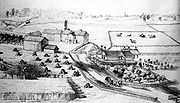
The town of Clairville was established in 1850 at the intersection of Albion Road and Steeles. It was built on land owned by Jean du Petit Pont de la Haye, a French teacher at Upper Canada CollegeUpper Canada College
Upper Canada College , located in midtown Toronto, Ontario, Canada, is an independent elementary and secondary school for boys between Senior Kindergarten and Grade Twelve, operating under the International Baccalaureate program. The secondary school segment is divided into ten houses; eight are...
. He developed the community on his estate which he named after his daughter Claire. A private street was built diagonally across northern Etobicoke as a shortcut to Albion Township (now part of Brampton), with a toll at Clairville. The street was originally named Clairville but was also called the Albion Road (the current name for this street).
Clairville largely disappeared after a dam was built on the West Branch of the Humber creating the Lake Clairville reservoir. In the 1970s Highway 427 was built north along the western edge of the neighbourhood and in the 1990s Highway 407 was built just to the north. This combined with the existing rail lines and proximity to Pearson Airport to make the area prime industrial land. Today almost all residents have left the area, and it is almost entirely warehouses and factories. Clairville was divided between municipalities, the portion west of Indian Road is today in Brampton. Unlike in Toronto, Claireville, Brampton largely consists of new residential subdivisions and the Clairville Conservation Area.
The area is close to the large south Asian communities of Brampton and Rexdale. The accessible area with large cheap lots has become home to several Hindu temples, most notably the BAPS Shri Swaminarayan Mandir Toronto
BAPS Shri Swaminarayan Mandir Toronto
BAPS Shri Swaminarayan Mandir Toronto is a Hindu temple in Toronto, Ontario, opened on July 22, 2007 by Pramukh Swami Maharaj, the spiritual leader of BAPS. Also in attendance at the ceremony were Canadian Prime Minister Stephen Harper with Ontario Premier Dalton McGuinty, Federal Opposition Leader...
.