

Rouge Park
Encyclopedia
Rouge Park will become an urban national park
located along the border of Toronto
and Pickering, Ontario
, Canada. It will be Canada's first national park within a municipality.
The lands now in the park were once home to resorts and cottages from the late 19th century to the 1950s. It is the only large valley land area in Toronto where people can still enjoy a wilderness experience, since other rivers in the city are now surrounded by urban development. People can still live a rural life, and even farm in the park. It is the only remaining rural area within the city of Toronto.
, the park consists of 50 square kilometres (12356 acres) of parkland, in Toronto
, Pickering
, Markham
and Stouffville. The park protects 12% of the Rouge River
watershed
, with park lands also protecting small parts of the Petticoat Creek and Duffins Creek watersheds, to the East. The Rouge River remains the healthiest river that flows through Toronto. Ecological preservation and restoration were needed. Preservation of near-urban agriculture is the park's main objective, though a recent decision to end leases for over 700 acres (2.8 km²) of farmland has generated considerable controversy.
Rouge is the largest nature park within a core of a metropolitan area in North America
. It stretches from Lake Ontario
in the south, north to the post-glacial Oak Ridges Moraine
in York Region.
The park is open with free admission to visitors year-round. Camping fees at seasonal campground apply. There are 12 km of rustic hiking trails in the Toronto part of the park. In Toronto, the park is accessible by public transport by TTC buses, and GO transit trains and buses.
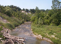
The Rouge Valley in the southern portion near Lake Ontario rises to 100m, but at the source the river valley rises to under 300m in height.The mouth of the Rouge River stays frost-free one month longer than northern areas of the river system on the Oak Ridges Moraine.Rouge Park has the largest and best examples of Canada's rare Carolinian habitat in Toronto and is the only officially recognized site in the Toronto area. Rouge Park is the only place where the Ontario Greenbelt
reaches Lake Ontario
in the City of Toronto.
Rouge Park's natural setting has provided filming locations for decades, posing as a backdrop for an array of landscapes, from the far north to the bayous of Mississippi. A Canadian filmmaker had a studio in the Park for many years, filming underwater beaver activity and simulating birds in flight.
 The park has:
A list of formal parks located within the Rouge Park system:
Brookside Golf Course at Staines Road and Steeles Avenue East is now the residential development called Brookside Village.
Glaciation occurred when average annual temperatures were only 2 - 5 °C lower than present. The small increase to our current temperatures caused big changes to the landscape. Increases in average annual temperatures now may seem small, but they could cause major changes to the natural environment in the near future.
Since humans began living in the area of the present Great Lakes-St Lawrence Lowlands in Ontario, many groups of people made the lands and waters now protected in Rouge Park their home.
The river and its valleys, uplands, forests and wetlands, along with the animal and plant species that lived here, sustained small nomadic groups, and later on larger, permanent settlements long before the rapid urbanization of the 20th century altered the landscape dramatically.
It protects two National Historic Sites:
to the Holland River
, linking Lake Ontario
in the south to Lake Simcoe
to the north.
This route was created by First Nations peoples, and later used by early European fur traders, explorers and settlers. The Rouge River route is not currently marked for the general public, but the western branch of the route, following the Humber River, has an official federal plaque. The Toronto Carrying-Place Trail
was designated by the Historical Sites and Monuments Board of Canada in 1969.
The edge between forest and meadow attracts a variety of plant and animal life.
Hiking trails, a sandy beach and access to other Toronto attractions are close to the campground, which is on the north side of Kingston Road / Highway 2, between Sheppard Avenue East and Altona Road.
From this viewpoint you can see the Rouge River and Little Rouge Creek valleys, a provincially-significant geologic feature and meadow species of plants and animals.
Features:
The marshes at Rouge Beach are the best and biggest in Toronto.The sandy beach is a popular summer spot for neighbours and visitors.
Features:
Memorial Park in Markham was named for the Canadian journalist, environmental activist, and co-founder of Greenpeace
. Created under Premier Dalton McGuinty
on August 21, 2006, the park added 500 acres to Rouge Park, and is bounded by a rail corridor, Ninth Line to the west, Reesor
Road to the east, Highway 407 to the north and Steeles Avenue East to the south.
The park, which is currently in development and scheduled to open in 2015, will feature trails, restored wetland, and replanted native woodland.
Its recipients were:
2008 - Ron Christie
2006 - Premier Dalton McGuinty
2004 - Gord Weeden
2003 - David Crombie, former MP and Toronto mayor
2002 - Save the Rouge Valley System Inc.
2001 - Jim Robb and Cathy Gregorio-Robb
2000 - Joyce Trimmer, former Scarborough mayor
1999 - Lois James
1998 - Honourable Pauline Browes
and Grand Cornell are also close to the park boundaries within Markham.
In Markham the Catholic Christ the King Cemetery was built within the park boundaries; future plans will prohibit new cemeteries within the park.
National park
A national park is a reserve of natural, semi-natural, or developed land that a sovereign state declares or owns. Although individual nations designate their own national parks differently A national park is a reserve of natural, semi-natural, or developed land that a sovereign state declares or...
located along the border of Toronto
Toronto
Toronto is the provincial capital of Ontario and the largest city in Canada. It is located in Southern Ontario on the northwestern shore of Lake Ontario. A relatively modern city, Toronto's history dates back to the late-18th century, when its land was first purchased by the British monarchy from...
and Pickering, Ontario
Pickering, Ontario
Pickering is a city located in Southern Ontario, Canada immediately east of Toronto in Durham Region. It is part of the Greater Toronto Area, the largest metropolitan area in Canada.- Early Period :...
, Canada. It will be Canada's first national park within a municipality.
The lands now in the park were once home to resorts and cottages from the late 19th century to the 1950s. It is the only large valley land area in Toronto where people can still enjoy a wilderness experience, since other rivers in the city are now surrounded by urban development. People can still live a rural life, and even farm in the park. It is the only remaining rural area within the city of Toronto.
Overview
Established in 1995 by the Province of OntarioOntario
Ontario is a province of Canada, located in east-central Canada. It is Canada's most populous province and second largest in total area. It is home to the nation's most populous city, Toronto, and the nation's capital, Ottawa....
, the park consists of 50 square kilometres (12356 acres) of parkland, in Toronto
Toronto
Toronto is the provincial capital of Ontario and the largest city in Canada. It is located in Southern Ontario on the northwestern shore of Lake Ontario. A relatively modern city, Toronto's history dates back to the late-18th century, when its land was first purchased by the British monarchy from...
, Pickering
Pickering, Ontario
Pickering is a city located in Southern Ontario, Canada immediately east of Toronto in Durham Region. It is part of the Greater Toronto Area, the largest metropolitan area in Canada.- Early Period :...
, Markham
Markham, Ontario
Markham is a town in the Regional Municipality of York, located within the Greater Toronto Area of Southern Ontario, Canada. The population was 261,573 at the 2006 Canadian census...
and Stouffville. The park protects 12% of the Rouge River
Rouge River (Ontario)
The Rouge River is a two river system. Little Rouge and Rouge River are in the east and the northeast parts of Toronto and begin in the Oak Ridges Moraine in Richmond Hill and Whitchurch-Stouffville...
watershed
Drainage basin
A drainage basin is an extent or an area of land where surface water from rain and melting snow or ice converges to a single point, usually the exit of the basin, where the waters join another waterbody, such as a river, lake, reservoir, estuary, wetland, sea, or ocean...
, with park lands also protecting small parts of the Petticoat Creek and Duffins Creek watersheds, to the East. The Rouge River remains the healthiest river that flows through Toronto. Ecological preservation and restoration were needed. Preservation of near-urban agriculture is the park's main objective, though a recent decision to end leases for over 700 acres (2.8 km²) of farmland has generated considerable controversy.
Rouge is the largest nature park within a core of a metropolitan area in North America
North America
North America is a continent wholly within the Northern Hemisphere and almost wholly within the Western Hemisphere. It is also considered a northern subcontinent of the Americas...
. It stretches from Lake Ontario
Lake Ontario
Lake Ontario is one of the five Great Lakes of North America. It is bounded on the north and southwest by the Canadian province of Ontario, and on the south by the American state of New York. Ontario, Canada's most populous province, was named for the lake. In the Wyandot language, ontarío means...
in the south, north to the post-glacial Oak Ridges Moraine
Oak Ridges Moraine
The Oak Ridges Moraine is an ecologically important geological landform in the Mixedwood Plains of south-central Ontario, Canada. The moraine covers a geographic area of between Caledon and Rice Lake, near Peterborough...
in York Region.
The park is open with free admission to visitors year-round. Camping fees at seasonal campground apply. There are 12 km of rustic hiking trails in the Toronto part of the park. In Toronto, the park is accessible by public transport by TTC buses, and GO transit trains and buses.
The Rouge Valley in the southern portion near Lake Ontario rises to 100m, but at the source the river valley rises to under 300m in height.The mouth of the Rouge River stays frost-free one month longer than northern areas of the river system on the Oak Ridges Moraine.Rouge Park has the largest and best examples of Canada's rare Carolinian habitat in Toronto and is the only officially recognized site in the Toronto area. Rouge Park is the only place where the Ontario Greenbelt
Greenbelt (Golden Horseshoe)
The Greenbelt is a permanently protected area of green space, farmland, forests, wetlands, and watersheds, located in Southern Ontario, Canada. It surrounds a significant portion of Canada's most populated and fastest-growing area - The Golden Horseshoe....
reaches Lake Ontario
Lake Ontario
Lake Ontario is one of the five Great Lakes of North America. It is bounded on the north and southwest by the Canadian province of Ontario, and on the south by the American state of New York. Ontario, Canada's most populous province, was named for the lake. In the Wyandot language, ontarío means...
in the City of Toronto.
Rouge Park's natural setting has provided filming locations for decades, posing as a backdrop for an array of landscapes, from the far north to the bayous of Mississippi. A Canadian filmmaker had a studio in the Park for many years, filming underwater beaver activity and simulating birds in flight.
Biodiversity
- 762 plant species, including 6 which are nationally rare and 92 which are regionally rare.
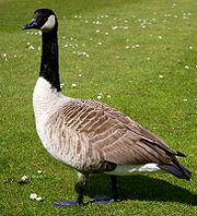
- 225 bird species, 5 of which are nationally rare breeding birds and 4 other breeding birds of special concern as well as numerous locally rare, area-sensitive raptor and colonial birds
- 55 fish species, 2 of which are nationally vulnerable
- 27 mammal species, some are locally rare
- 19 reptile and amphibian species, some are locally rare
Parks
With the exception of the southeastern and southern sections of the park, the remaining parts of Rouge Park are located within the agriculture belt in York Region and parts of northeastern Toronto.A list of formal parks located within the Rouge Park system:
- Bruce's Mills Conservation Area, Whitchurch-Stouffville, Ontario
- Phyllis Rawlinson Park, Richmond Hill, Ontario
- Toogood Pond, Markham, Ontario
- Milne Park, Markham, Ontario
- Glen Rouge Park, Toronto
- Rouch Beach Park, Toronto
- Bob Hunter Memorial Park, Markham
Golf Courses
There are three golf courses that has the Rouge running through it:- Parkview Golf Course, Markam - Remington Homes owned course formerly part of IBM Canada Golf Course (opened 1960)
- Markham Green Golf Course, Markam - formerly part of IBM Canada Golf Course (c. 1960) and Box Grove Golf Club (c. 1940s)
- Cedar Brae Golf and Country Club, Toronto (opened 1954)
Brookside Golf Course at Staines Road and Steeles Avenue East is now the residential development called Brookside Village.
Waterways
- Rouge River, Toronto and Markham,
- Morningside Creek, Toronto and Markham
- Carleton Creek, Markham
- Beaver Creek, Richmond Hill
- Little Rouge Creek, Toronto, Markham and Whitchurch-Stouffville
- Berczy Creek, Markham
Glaciation
Water from glaciers melting 12,000 years ago formed ancestral Lake Ontario, which covered this entire area. A large ice lobe, roughly 20 metres thick, blocked the lake from draining eastward, leaving water levels high as the lake slowly drained south to what is now the Mississippi River. The ice lobe finally retreated, draining the lake to the St Lawrence River and forming the Great Lakes as we see them today.Glaciation occurred when average annual temperatures were only 2 - 5 °C lower than present. The small increase to our current temperatures caused big changes to the landscape. Increases in average annual temperatures now may seem small, but they could cause major changes to the natural environment in the near future.
Historical Importance
The human history of Rouge Park goes back over 10,000 years. Palaeolithic nomadic hunters, Iroquoian women farmers, early European explorers, and the multicultural suburban population that one can see around the Park today are all part of this history.Since humans began living in the area of the present Great Lakes-St Lawrence Lowlands in Ontario, many groups of people made the lands and waters now protected in Rouge Park their home.
The river and its valleys, uplands, forests and wetlands, along with the animal and plant species that lived here, sustained small nomadic groups, and later on larger, permanent settlements long before the rapid urbanization of the 20th century altered the landscape dramatically.
It protects two National Historic Sites:
Toronto Carrying Place
This was an original portage route along the Rouge RiverRouge River (Ontario)
The Rouge River is a two river system. Little Rouge and Rouge River are in the east and the northeast parts of Toronto and begin in the Oak Ridges Moraine in Richmond Hill and Whitchurch-Stouffville...
to the Holland River
Holland River
The Holland River is a river in Ontario, Canada that drains the Holland River watershed into Cook's Bay, the southern extremity of Lake Simcoe. It is named after Captain Samuel Holland, , Dutch born first Surveyor General of British North America. The river flows generally north, and its...
, linking Lake Ontario
Lake Ontario
Lake Ontario is one of the five Great Lakes of North America. It is bounded on the north and southwest by the Canadian province of Ontario, and on the south by the American state of New York. Ontario, Canada's most populous province, was named for the lake. In the Wyandot language, ontarío means...
in the south to Lake Simcoe
Lake Simcoe
Lake Simcoe is a lake in Southern Ontario, Canada, the fourth-largest lake wholly in the province, after Lake Nipigon, Lac Seul, and Lake Nipissing. At the time of the first European contact in the 17th century the lake was called Ouentironk by the Huron natives...
to the north.
This route was created by First Nations peoples, and later used by early European fur traders, explorers and settlers. The Rouge River route is not currently marked for the general public, but the western branch of the route, following the Humber River, has an official federal plaque. The Toronto Carrying-Place Trail
Toronto Carrying-Place Trail
The Toronto Carrying-Place Trail, also known as the Humber Portage and the Toronto Passage, was a major portage route in Ontario, Canada, linking Lake Ontario with Lake Simcoe and the northern Great Lakes...
was designated by the Historical Sites and Monuments Board of Canada in 1969.
Bead Hill
The archeological site of an intact 17th century Seneca village was designated a National Historic Site of Canada in 1991. The site includes the remains of an Archaic campsite, dating about 3,000 years old. Minimal excavations have been carried out, and the site includes a naturally-protected midden, which is thought to contain a wealth of material. Because of its sensitive archaeological nature, it is not open to the public nor readily identified in the park. Its national historic site designation was prompted by imminent development plans that could have encroached on the area.Geological Study
Outcrops of rock formed during the last glacial period are found in Rouge Park and are important to geologists studying seismic activity, in particular the risk of earthquakes in the Toronto area. Faults are visible indicating significant earthquake activity between 80,000 and 13,000 years ago.Celebration Forest
Across from Twyn Rivers Area, you can visit our park memorial where we have honoured friends and supporters of Rouge Park, as well as those who contributed to the natural heritage legacy of the area that eventually became protected in the Park.The edge between forest and meadow attracts a variety of plant and animal life.
Glen Rouge Campground
Toronto's only camping spot, the Glen Rouge Campground, is easy to reach from highways and is on the banks of the Rouge River. A safe and comfortable camping experience.Hiking trails, a sandy beach and access to other Toronto attractions are close to the campground, which is on the north side of Kingston Road / Highway 2, between Sheppard Avenue East and Altona Road.
Glen Eagles Vista
Glen Eagles Vista is a viewpoint with outstanding view of river valleys and geologic features.From this viewpoint you can see the Rouge River and Little Rouge Creek valleys, a provincially-significant geologic feature and meadow species of plants and animals.
Features:
- 0.6 km long trail
- Vista point with outstanding view of river valleys and geologic feature
- Short trail with interpretive signs and native vegetation
Rouge Beach
Where the Rouge River meets Lake Ontario, there's a sandy beach and a wetland full of wildlife.The marshes at Rouge Beach are the best and biggest in Toronto.The sandy beach is a popular summer spot for neighbours and visitors.
Features:
- Sandy beach
- Swimming (beach is open seasonally in accordance with Toronto Public Health approval and lifeguard on duty when officially open)
- View of Lake Ontario and shoreline east to Pickering
- Marshes offer wildlife viewing
- Canoeing on river and in marshes. NO motorized boating permitted.
- Fishing access. Seasonal provincial license required.
- Easily accessible boardwalk and pathway near marshes
- Access to Lake Ontario Waterfront Trail
Twyn Rivers area
The remains of an old dam are still visible in the creek. In the 1950s, a hotel in the valley was a popular vacation spot and the river was dammed for swimming. People often skied on the hill on the south side of the creek. Nearby, the remains of old orchards and farms are reminders of former residents in the area.Bob Hunter Memorial Park
The Bob HunterRobert Hunter (journalist)
Robert Lorne Hunter was a Canadian environmentalist, journalist, author and politician. A member of the Don't Make a Wave Committee in 1969 with Dorothy and Irving Stowe, Marie and Jim Bohlen, and Ben and Dorothy Metcalfe...
Memorial Park in Markham was named for the Canadian journalist, environmental activist, and co-founder of Greenpeace
Greenpeace
Greenpeace is a non-governmental environmental organization with offices in over forty countries and with an international coordinating body in Amsterdam, The Netherlands...
. Created under Premier Dalton McGuinty
Dalton McGuinty
Dalton James Patrick McGuinty, Jr., MPP is a Canadian lawyer, politician and, since October 23, 2003, the 24th and current Premier of the Canadian province of Ontario....
on August 21, 2006, the park added 500 acres to Rouge Park, and is bounded by a rail corridor, Ninth Line to the west, Reesor
Peter Reesor
Peter Reesor is the founder of Markham, Ontario.Peter Reesor was born December 25 1775, in Lancaster County, Pennsylvania to Christian Reesor and Veronica Reiff .- Peter's First Visit to Canada :...
Road to the east, Highway 407 to the north and Steeles Avenue East to the south.
The park, which is currently in development and scheduled to open in 2015, will feature trails, restored wetland, and replanted native woodland.
Channel Enlargement
The Rouge River watershed, the geographic area where all lands drain into the Rouge River system, is reacting to rapid urbanization and change. Many sections of the watershed are no longer stable and are experiencing channel enlargement, largely due to surface runoff from the impervious surfaces which are the result of urbanization, and the application of engineered technology in an attempt to manage the increased flows.Rouge Park Award
Each year, the Rouge Park Alliance recognizes members of the community who have made outstanding contributions to the Rouge Park goal, vision and objectives through the Rouge Park Awards.Its recipients were:
2008 - Ron Christie
2006 - Premier Dalton McGuinty
2004 - Gord Weeden
2003 - David Crombie, former MP and Toronto mayor
2002 - Save the Rouge Valley System Inc.
2001 - Jim Robb and Cathy Gregorio-Robb
2000 - Joyce Trimmer, former Scarborough mayor
1999 - Lois James
1998 - Honourable Pauline Browes
Threats
The future of Rouge Park is threatened by urban growth in both Markham and Toronto, namely from residential development along the Rouge and tributaries. Morningside Heights and a residential development along Staines Road and Steeles Avenue East (Brookside Village, formerly Brookside Golf Course) were approved within Toronto despite being located along tributaries of the Rouge River and on the edge of the parkland. The communities of Box GroveBox Grove, Ontario
Box Grove is an original community in Markham, Ontario.-History:First settled in 1815 by William Beebe, Sparta or Sparty-Wharf was registered as a hamlet in 1850. The name suggests that at an early date there was boat traffic on the Rouge River...
and Grand Cornell are also close to the park boundaries within Markham.
In Markham the Catholic Christ the King Cemetery was built within the park boundaries; future plans will prohibit new cemeteries within the park.
External Links
- Rouge Park website
- Toronto and Region Conservation Authority, Rouge River Watershed Plan, 2007.