
East Danforth
Encyclopedia
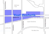
East Danforth is a neighbourhood in Toronto
, Canada
. It is located on the eastern part of Danforth Avenue
in the old city of Toronto. It stretches from the eastern edge of Greektown by Jones Avenue to the boundary of Scarborough
at Victoria Park Avenue
. The area is covered by two business improvement associations, Danforth Village and Danforth Mosaic. To the north of the neighbourhood is Old East York
, once a separate municipality, but today closely integrated into the area. The southern border is the railway tracks, beyond which is Leslieville
and the Upper Beaches
. According to the 2006 census the area has a population of 14,629.
. The turn of the 20th century also brought the construction of the Prince Edward Viaduct connecting Bloor and Danforth, which encouraged the development of the Luttrell Loop on Danforth, and a streetcar terminus for the Bloor-Danforth, Gerrard and former Coxwell streetcar routes which connected to the old train station.
The area developed from the 1910s thru the 1930s as a streetcar suburb
along the Danforth streetcar line. Most of the housing to the north and south of the street dates from this period. In 1966 the Bloor-Danforth subway line replaced the streetcar. The neighbourhood is served by six subway stations: Donlands
, Greenwood
, Coxwell
, Woodbine
, Main Street
, and Victoria Park
. In the 1960s and 1970s a number of apartment towers were built in the area, most notably the Crescent Town area just north of Danforth at Victoria Park and the Main Square
complex south of Danforth at Main Street. Most of the area remains low-rise, with low-end stores along Danforth and single-family homes to the north and south. At the far east of the neighborhood is the Shoppers' World Danforth, a strip/shopping mall built in 1962 (revamped in the 1990s), and anchored by a Zellers
and housed in a former munitions factory. The neighborhood is home to a large Muslim community. Under construction is the Madina Masjid, which will be one of the largest mosques in Toronto.
Gledhill Public School, located at 2 Gledhill Avenue, is an elementary school, offering classes from Junior Kindergarten to Grade 6.
Toronto
Toronto is the provincial capital of Ontario and the largest city in Canada. It is located in Southern Ontario on the northwestern shore of Lake Ontario. A relatively modern city, Toronto's history dates back to the late-18th century, when its land was first purchased by the British monarchy from...
, Canada
Canada
Canada is a North American country consisting of ten provinces and three territories. Located in the northern part of the continent, it extends from the Atlantic Ocean in the east to the Pacific Ocean in the west, and northward into the Arctic Ocean...
. It is located on the eastern part of Danforth Avenue
Danforth Avenue
Danforth Avenue is an east-west arterial road in Toronto, Ontario, Canada. Its western end begins in Old Toronto from the Prince Edward Viaduct as a continuation of Bloor Street and continues through East York until intersecting with Kingston Road in Scarborough...
in the old city of Toronto. It stretches from the eastern edge of Greektown by Jones Avenue to the boundary of Scarborough
Scarborough, Ontario
Scarborough is a dissolved municipality within the city of Toronto, Ontario, Canada. Geographically, it comprises the eastern part of Toronto. It is bordered on the south by Lake Ontario, on the west by Victoria Park Avenue, on the north by Steeles Avenue East, and on the east by the Rouge River...
at Victoria Park Avenue
Victoria Park Avenue
Victoria Park Avenue is a major north-south route in eastern Toronto, Ontario, Canada. It marks the border between the Old City of Toronto and Scarborough.-History:Victoria Park Avenue was originally a pioneer road for settlement of Scarborough...
. The area is covered by two business improvement associations, Danforth Village and Danforth Mosaic. To the north of the neighbourhood is Old East York
Old East York
Old East York is a neighbourhood in the city of Toronto located in the former East York. While East York was a much larger area, the name has been kept as a reminder to the days before the mega city. There are multiple definitions of its extent, but at its largest Old East York has covers the...
, once a separate municipality, but today closely integrated into the area. The southern border is the railway tracks, beyond which is Leslieville
Leslieville
Leslieville is a neighbourhood in Toronto, Ontario, Canada east of the Don River bounded by the Canadian National railway line and Gerrard Street to the north, Empire Avenue to the west, Eastern Avenue to south, and Coxwell Avenue to the east.-History:...
and the Upper Beaches
Upper Beaches
The Upper Beaches is a rather recently coined name for the neighbourhood directly north of the Beaches area in Toronto, Ontario, Canada. It stretches from Coxwell Avenue in the west to Victoria Park in the east. The southern border is Kingston Road, while the northern boundary is generally...
. According to the 2006 census the area has a population of 14,629.
History
The area first appeared in the 19th century as the 'Coleman' postal village centered on the intersection of Danforth and Dawes (a street built through the lands of the local Taylor family) with a general store and inn. With the building of the railways in the mid-19th century the area acquired a train station, East Toronto. By the turn of the century the area was called "Little York" (an original name of Toronto) and became a part of the short-lived Town of East TorontoEast Toronto
East Toronto, Ontario was an incorporated community in what is today a part of the city of Toronto, Canada. It covered much of what is today the Upper Beaches neighbourhood, stretching up to Danforth Avenue in the north. The central street in the community was Main Street, running south from...
. The turn of the 20th century also brought the construction of the Prince Edward Viaduct connecting Bloor and Danforth, which encouraged the development of the Luttrell Loop on Danforth, and a streetcar terminus for the Bloor-Danforth, Gerrard and former Coxwell streetcar routes which connected to the old train station.
The area developed from the 1910s thru the 1930s as a streetcar suburb
Streetcar suburb
A streetcar suburb is a residential community whose growth and development was strongly shaped by the use of streetcar lines as a primary means of transportation. Early suburbs were served by horsecars, but by the late 19th century cable cars and electric streetcars, or trams, were used, allowing...
along the Danforth streetcar line. Most of the housing to the north and south of the street dates from this period. In 1966 the Bloor-Danforth subway line replaced the streetcar. The neighbourhood is served by six subway stations: Donlands
Donlands (TTC)
Donlands is a station on the Bloor–Danforth line of the subway system in Toronto, Canada. It is located at 990 Danforth Avenue at Donlands Avenue.-History:...
, Greenwood
Greenwood (TTC)
Greenwood is a station on the Bloor–Danforth line of the Toronto subway system. It is located on the corner of Linnsmore Crescent and Strathmore Boulevard near 1177 Danforth Avenue, one block east of Greenwood Avenue...
, Coxwell
Coxwell (TTC)
Coxwell is a station on the Bloor–Danforth line of the subway system in Toronto, Canada. The official address is 1568 Danforth Avenue but the entrance is located on Strathmore Boulevard just east of Coxwell Avenue...
, Woodbine
Woodbine (TTC)
Woodbine is a station on the Bloor–Danforth line of the subway system in Toronto, Canada. The address of the station is 2072 Danforth Avenue and it is physically located at the intersection of Woodbine Avenue and Strathmore Boulevard....
, Main Street
Main Street (TTC)
Main Street is a station on the Bloor–Danforth line of the subway system in Toronto, Canada. It is located at 2550 Danforth Avenue at Main Street, in Danforth Village. 350 metres to the south, Main Street connects to Danforth station on GO Transit's Lakeshore East railway line.This station is...
, and Victoria Park
Victoria Park (TTC)
Victoria Park is a station on the Bloor–Danforth line of the subway system in Toronto, Canada. It is located at 777 Victoria Park Avenue, one block north of Danforth Avenue. The station itself can be accessed by pedestrians via Victoria Park Avenue, or via Albion Avenue, or via a walkway that leads...
. In the 1960s and 1970s a number of apartment towers were built in the area, most notably the Crescent Town area just north of Danforth at Victoria Park and the Main Square
Main Square
Main Square is a complex of four apartment buildings in Toronto, Canada. The three-hectare site houses about 2000 people. It is located in the eastern part of the city at the intersection of Main Street and Danforth Avenue. The complex is located just north of the railway lines and the Danforth GO...
complex south of Danforth at Main Street. Most of the area remains low-rise, with low-end stores along Danforth and single-family homes to the north and south. At the far east of the neighborhood is the Shoppers' World Danforth, a strip/shopping mall built in 1962 (revamped in the 1990s), and anchored by a Zellers
Zellers
Zellers Inc. is Canada's second-largest chain of mass merchandise discount stores, with locations in communities across Canada. A subsidiary of the Hudson's Bay Company , it has 273 locations across the country....
and housed in a former munitions factory. The neighborhood is home to a large Muslim community. Under construction is the Madina Masjid, which will be one of the largest mosques in Toronto.
Schools
Earl Haig Public School is a Elementary-Middle School located at 15 Earl Haig Avenue, just east of Coxwell. Earl Haig only went from Kindergarten-Grade 6 until 2009-2010, when grade seven was added. In the 2010-2011 school year, the school added Grade 8 as well.Gledhill Public School, located at 2 Gledhill Avenue, is an elementary school, offering classes from Junior Kindergarten to Grade 6.