

List of islands of France
Encyclopedia
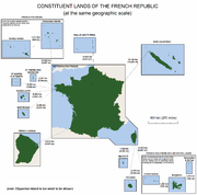
Metropolitan France
Metropolitan France is the part of France located in Europe. It can also be described as mainland France or as the French mainland and the island of Corsica...
France
France
The French Republic , The French Republic , The French Republic , (commonly known as France , is a unitary semi-presidential republic in Western Europe with several overseas territories and islands located on other continents and in the Indian, Pacific, and Atlantic oceans. Metropolitan France...
and French overseas islands.
By area
All French islands over 100 km², ranked by decreasing area.| Name | Location | Area (km²) |
|
|---|---|---|---|
| 1 | New Caledonia New Caledonia New Caledonia is a special collectivity of France located in the southwest Pacific Ocean, east of Australia and about from Metropolitan France. The archipelago, part of the Melanesia subregion, includes the main island of Grande Terre, the Loyalty Islands, the Belep archipelago, the Isle of... 's mainland (Grande-Terre) |
New Caledonia | 16372 |
| 2 | Corsica Corsica Corsica is an island in the Mediterranean Sea. It is located west of Italy, southeast of the French mainland, and north of the island of Sardinia.... |
Mediterranean Sea Mediterranean Sea The Mediterranean Sea is a sea connected to the Atlantic Ocean surrounded by the Mediterranean region and almost completely enclosed by land: on the north by Anatolia and Europe, on the south by North Africa, and on the east by the Levant... |
8680 |
| 3 | Grande-Terre | Kerguelen Islands Kerguelen Islands The Kerguelen Islands , also known as the Desolation Islands, are a group of islands in the southern Indian Ocean constituting the emerged part of the otherwise submerged Kerguelen Plateau. The islands, along with Adélie Land, the Crozet Islands and the Amsterdam and Saint Paul Islands are part of... |
6675 |
| 4 | Réunion Réunion Réunion is a French island with a population of about 800,000 located in the Indian Ocean, east of Madagascar, about south west of Mauritius, the nearest island.Administratively, Réunion is one of the overseas departments of France... |
Réunion Réunion Réunion is a French island with a population of about 800,000 located in the Indian Ocean, east of Madagascar, about south west of Mauritius, the nearest island.Administratively, Réunion is one of the overseas departments of France... |
2512 |
| 5 | Lifou Lifou Lifou is a commune in the Loyalty Islands Province of New Caledonia in the Pacific Ocean.-Geography:Lifou is made up of Lifou Island, the largest and most heavily populated of the Loyalty Islands, its smaller neighbour Tiga Island, and several uninhabited islets in between these two... |
New Caledonia | 1146 |
| 6 | Martinique Martinique Martinique is an island in the eastern Caribbean Sea, with a land area of . Like Guadeloupe, it is an overseas region of France, consisting of a single overseas department. To the northwest lies Dominica, to the south St Lucia, and to the southeast Barbados... |
Martinique | 1128 |
| 7 | Tahiti Tahiti Tahiti is the largest island in the Windward group of French Polynesia, located in the archipelago of the Society Islands in the southern Pacific Ocean. It is the economic, cultural and political centre of French Polynesia. The island was formed from volcanic activity and is high and mountainous... |
French Polynesia French Polynesia French Polynesia is an overseas country of the French Republic . It is made up of several groups of Polynesian islands, the most famous island being Tahiti in the Society Islands group, which is also the most populous island and the seat of the capital of the territory... |
1036 |
| 8 | Basse-Terre Basse-Terre Island Basse-Terre Island is the name of the western-half of Guadeloupe proper, in the Lesser Antilles. It is separated from the other half of Guadeloupe proper, Grande-Terre, by a narrow sea channel called the Rivière Salée .... |
Guadeloupe Guadeloupe Guadeloupe is an archipelago located in the Leeward Islands, in the Lesser Antilles, with a land area of 1,628 square kilometres and a population of 400,000. It is the first overseas region of France, consisting of a single overseas department. As with the other overseas departments, Guadeloupe... |
848 |
| 9 | Maré Maré Maré is a commune in the Loyalty Islands Province of New Caledonia, an overseas territory of France in the Pacific Ocean.The commune of Maré is made up of Maré Island and the much smaller Dudun Island, which lie among the Loyalty Islands, to the northeast of New Caledonia's mainland. The settlement... |
New Caledonia | 657 |
| 10 | Grande-Terre Grande-Terre Grande-Terre is an island in the Guadeloupe, separated by Basse-Terre Island by a salt river. Grande-Terre's northernmost point, Pointe de la Grande Vigie, is also the northernmost point in Guadeloupe.... |
Guadeloupe | 586 |
| 11 | Mayotte Mayotte Mayotte is an overseas department and region of France consisting of a main island, Grande-Terre , a smaller island, Petite-Terre , and several islets around these two. The archipelago is located in the northern Mozambique Channel in the Indian Ocean, namely between northwestern Madagascar and... 's mainland (Grande-Terre) |
Mayotte | 363 |
| 12 | Nuku Hiva Nuku Hiva Nuku Hiva is the largest of the Marquesas Islands in French Polynesia, an overseas territory of France in the Pacific Ocean. It was formerly also known as Île Marchand and Madison Island.... |
French Polynesia | 345 |
| 13 | Hiva Oa Hiva Oa Hiva Oa is the second largest island in the Marquesas Islands, in French Polynesia, an overseas territory of France in the Pacific Ocean. It is the largest island of the Southern Marquesas group. According to local religion, the gods created the islands as their home. Therefore all islands have... |
French Polynesia | 318 |
| 14 | Miquelon Miquelon Miquelon may refer to*Saint Pierre and Miquelon, a territorial collectivity of France**Miquelon-Langlade, the less populous of two communes which are part of Saint Pierre and Miquelon***Miquelon, Miquelon-Langlade, the capital thereof... |
Saint-Pierre-et-Miquelon | 214 |
| 15 | Île Foch Île Foch Île Foch is one of the Kerguelen Islands situated near to the north coast of Grand Terre, the principal island.It is separated from this main island only by a narrow sea arm, the Tucker strait. It borders île Saint-Lanne Gramont at the northwest, which is separated by the Baie de Londres... |
Kerguelen Islands | 206 |
| 16 | Oléron Oléron Île d'Oléron is an island off the Atlantic coast of France , on the southern side of the Pertuis d'Antioche strait.... |
Atlantic Ocean Atlantic Ocean The Atlantic Ocean is the second-largest of the world's oceanic divisions. With a total area of about , it covers approximately 20% of the Earth's surface and about 26% of its water surface area... |
190 |
| 17 | Raiatea Raiatea Raiatea , is the second largest of the Society Islands, after Tahiti, in French Polynesia. The island is widely regarded as the 'center' of the eastern islands in ancient Polynesia and it is likely that the organised migrations to Hawaii, Aotearoa and other parts of East Polynesia started at... |
French Polynesia | 173 |
| 18 | Marie-Galante Marie-Galante Marie-Galante is an island of the Caribbean Sea located at the south of Guadeloupe and at north of Dominica. Marie-Galante is a dependence of Guadeloupe which is a french overseas department.... |
Guadeloupe | 158 |
| 19 | Île de la Possession | Crozet Islands Crozet Islands The Crozet Islands are a sub-antarctic archipelago of small islands in the southern Indian Ocean. They form one of the five administrative districts of the French Southern and Antarctic Lands.-Geography:... |
153 |
| 20 | Île des Pins | New Caledonia | 141 |
| 21 | Ouvéa Ouvéa Ouvéa is a commune in the Loyalty Islands Province of New Caledonia, an overseas territory of France in the Pacific Ocean. The settlement of Fayaoué , on Ouvéa Island, is the administrative centre of the commune of Ouvéa. -Geography:... |
New Caledonia | 133 |
| 22 | Moorea Moorea Moʻorea is a high island in French Polynesia, part of the Society Islands, 17 km northwest of Tahiti. Its position is . Moʻorea means "yellow lizard" in Tahitian... |
French Polynesia | 132 |
| 23 | Île de l'Est Île de l'Est Île de l'Est is a part of the sub-Antarctic archipelago Crozet Islands. With it is the second largest island of this group. It belongs to the French territory French Southern and Antarctic Lands.- See also :* List of Antarctic islands north of 60° S... |
Crozet Islands | 122 |
| 24 | Ua Pou | French Polynesia | 112 |
By population
List of the most populated French islands.| Name | Location | Population | |
|---|---|---|---|
| 1 | Réunion Réunion Réunion is a French island with a population of about 800,000 located in the Indian Ocean, east of Madagascar, about south west of Mauritius, the nearest island.Administratively, Réunion is one of the overseas departments of France... |
Indian Ocean Indian Ocean The Indian Ocean is the third largest of the world's oceanic divisions, covering approximately 20% of the water on the Earth's surface. It is bounded on the north by the Indian Subcontinent and Arabian Peninsula ; on the west by eastern Africa; on the east by Indochina, the Sunda Islands, and... |
802,000 (Jan. 2008) |
| 2 | Martinique Martinique Martinique is an island in the eastern Caribbean Sea, with a land area of . Like Guadeloupe, it is an overseas region of France, consisting of a single overseas department. To the northwest lies Dominica, to the south St Lucia, and to the southeast Barbados... |
Caribbean Caribbean The Caribbean is a crescent-shaped group of islands more than 2,000 miles long separating the Gulf of Mexico and the Caribbean Sea, to the west and south, from the Atlantic Ocean, to the east and north... |
402,000 (Jan. 2008) |
| 3 | Corsica Corsica Corsica is an island in the Mediterranean Sea. It is located west of Italy, southeast of the French mainland, and north of the island of Sardinia.... |
Mediterranean | 302,000 (Jan. 2008) |
| 4 | New Caledonia New Caledonia New Caledonia is a special collectivity of France located in the southwest Pacific Ocean, east of Australia and about from Metropolitan France. The archipelago, part of the Melanesia subregion, includes the main island of Grande Terre, the Loyalty Islands, the Belep archipelago, the Isle of... 's mainland (Grande-Terre) |
Pacific | 205,939 (Aug. 2004) |
| 5 | Guadeloupe Guadeloupe Guadeloupe is an archipelago located in the Leeward Islands, in the Lesser Antilles, with a land area of 1,628 square kilometres and a population of 400,000. It is the first overseas region of France, consisting of a single overseas department. As with the other overseas departments, Guadeloupe... 's Grande-Terre Grande-Terre Grande-Terre is an island in the Guadeloupe, separated by Basse-Terre Island by a salt river. Grande-Terre's northernmost point, Pointe de la Grande Vigie, is also the northernmost point in Guadeloupe.... |
Caribbean | 197,603 (Jan. 2006) |
| 6 | Guadeloupe Guadeloupe Guadeloupe is an archipelago located in the Leeward Islands, in the Lesser Antilles, with a land area of 1,628 square kilometres and a population of 400,000. It is the first overseas region of France, consisting of a single overseas department. As with the other overseas departments, Guadeloupe... 's Basse-Terre Basse-Terre Island Basse-Terre Island is the name of the western-half of Guadeloupe proper, in the Lesser Antilles. It is separated from the other half of Guadeloupe proper, Grande-Terre, by a narrow sea channel called the Rivière Salée .... |
Caribbean | 186,661 (Jan. 2006) |
| 7 | Tahiti Tahiti Tahiti is the largest island in the Windward group of French Polynesia, located in the archipelago of the Society Islands in the southern Pacific Ocean. It is the economic, cultural and political centre of French Polynesia. The island was formed from volcanic activity and is high and mountainous... |
Pacific | 178,133 (Aug. 2007) |
| 8 | Mayotte Mayotte Mayotte is an overseas department and region of France consisting of a main island, Grande-Terre , a smaller island, Petite-Terre , and several islets around these two. The archipelago is located in the northern Mozambique Channel in the Indian Ocean, namely between northwestern Madagascar and... 's mainland (Grande Terre) |
Indian Ocean | 162,036 (Jul. 2007) |
| 9 | Saint Martin Saint Martin (France) Saint Martin , officially the Collectivity of Saint Martin is an overseas collectivity of France located in the Caribbean. It came into being on 15 July 2007, encompassing the northern parts of Saint Martin island and neighbouring islets, the largest of which is Île Tintamarre... (French part only) |
Caribbean | 35,263 (Jan. 2006) |
| 10 | Mayotte's Petite Terre (aka Pamanzi Pamanzi Pamanzi, known as Petite-Terre in French, is an island just off Mayotte, and is the second largest island after Mayotte itself. It was once the most important island, with Mayotte's only airport and the capital Dzaoudzi, until 1977 when Mamoudzou was chosen as the new capital. The communes of... ) |
Indian Ocean | 24,416 (Jul. 2007) |
| 11 | Oléron Oléron Île d'Oléron is an island off the Atlantic coast of France , on the southern side of the Pertuis d'Antioche strait.... |
Bay of Biscay Bay of Biscay The Bay of Biscay is a gulf of the northeast Atlantic Ocean located south of the Celtic Sea. It lies along the western coast of France from Brest south to the Spanish border, and the northern coast of Spain west to Cape Ortegal, and is named in English after the province of Biscay, in the Spanish... |
20,991 (Jan. 2006) |
| 12 | Île de Ré Île de Ré Île de Ré is an island off the west coast of France near La Rochelle, on the northern side of the Pertuis d'Antioche strait.... |
Bay of Biscay | 17,640 (Jan. 2006) |
| 13 | Moorea Moorea Moʻorea is a high island in French Polynesia, part of the Society Islands, 17 km northwest of Tahiti. Its position is . Moʻorea means "yellow lizard" in Tahitian... |
Pacific | 16,191 (Aug. 2007) |
| 14 | Raiatea Raiatea Raiatea , is the second largest of the Society Islands, after Tahiti, in French Polynesia. The island is widely regarded as the 'center' of the eastern islands in ancient Polynesia and it is likely that the organised migrations to Hawaii, Aotearoa and other parts of East Polynesia started at... |
Pacific | 12,024 (Aug. 2007) |
| 15 | Marie-Galante Marie-Galante Marie-Galante is an island of the Caribbean Sea located at the south of Guadeloupe and at north of Dominica. Marie-Galante is a dependence of Guadeloupe which is a french overseas department.... |
Caribbean | 12,009 (Jan. 2006) |
| 16 | Lifou Lifou Island Lifou Island is the largest and most important island of the Loyalty Islands, in the archipelago of New Caledonia, an overseas territory of France in the Pacific Ocean. It is located at .-Administration:... |
Pacific | 10,170 (Aug. 2004) |
| 17 | Noirmoutier Île de Noirmoutier The island of Noirmoutier is off the Atlantic coast of France in the Vendée department.Parts of the island have been reclaimed from the sea. In 2005 it served as the finish of the Tour de France prologue.... |
Bay of Biscay | 9,813 (Jan. 2006) |
| 18 | Wallis Wallis Island Wallis is an island in the Pacific Ocean belonging to the French overseas collectivity of Wallis and Futuna.... (aka Uvea) |
Pacific | 9,227 (Jul. 2008) |
| 19 | Bora Bora Bora Bora The commune of Bora-Bora is made up of the island of Bora Bora proper with its surrounding islets emerging from the coral reef, 29.3 km² in total, and of the atoll of Tupai , located north of Bora Bora... |
Pacific | 8,927 (Aug. 2007) |
| 20 | Saint Barthélemy Saint Barthélemy Saint Barthélemy , officially the Territorial collectivity of Saint Barthélemy , is an overseas collectivity of France. Often abbreviated to Saint-Barth in French, or St. Barts in English, the indigenous people called the island Ouanalao... |
Caribbean | 8,450 (Jan. 2007) |
Normandy
- ChauseyChauseyChausey is a group of small islands, islets and rocks off the coast of Normandy, in the English Channel. It lies from Granville, and forms a quartier of the Granville commune, in the Manche département...
:- Grande-ÎleGrande-Île, NormandyGrande-Île is the largest of the islands of Chausey located near the Channel Islands off the coast of Normandy in France. The island is 1.5 kilometres long and 0.5 kilometres wide at its widest being approximately 45 hectares ) in area.- External links :*...
- Grande-Île
- Mont Saint-MichelMont Saint-MichelMont Saint-Michel is a rocky tidal island and a commune in Normandy, France. It is located approximately one kilometre off the country's north-western coast, at the mouth of the Couesnon River near Avranches...
(by very high tide) - TombelaineTombelainethumb|right|Tombelaine and Mont Saint Michel Tombelaine is a small tidal island off the coast of Normandy in France. It lies a few kilometres north of Mont Saint-Michel. At low tide the island can be reached on foot from the coast of Cotentin, 3.5 km to the north-east, and from Mont...
(tidal) - TatihouTatihouTatihou is an island of Normandy in France with an area of 290,000 square metres. It is located to the east of the Cotentin peninsula just off the coast near Saint-Vaast-la-Hougue. It is almost uninhabited, and is usually reached by amphibious boat although, being a tidal island, it is also...
(high tide)
- Îles Saint-MarcoufÎles Saint-MarcoufÎles Saint-Marcouf are a group of two small uninhabited islands off the coast of Normandy, France. They lie in the Baie de la Seine region of the English Channel and are 6.5 kilometres east of the coast of the Cotentin peninsula at Ravenoville and 13 kilometres from the island of Tatihou...
:- Île de Large
- Île de Terre
Ille et Vilaine
- Saint-MaloSaint-MaloSaint-Malo is a walled port city in Brittany in northwestern France on the English Channel. It is a sub-prefecture of the Ille-et-Vilaine.-Demographics:The population can increase to up to 200,000 in the summer tourist season...
Islands- CézembreCézembreCézembre is an island in the Ille-et-Vilaine département of France, near Saint-Malo. The island is uninhabited, with a surface area of approximately 18 hectares , a length of 750 meters, and a width of 300 meters....
- Grand BéGrand BéGrand Bé is a tidal island near Saint-Malo, France. It is located at the mouth of the Rance River, a few hundred meters from the walls of Saint-Malo. At low tide the island can be reached on foot from the nearby Bon-Secours beach...
- Petit BéPetit BéPetit Bé is a tidal island near Saint-Malo, France, close to the larger island of Grand Bé. At low tide the island can be reached on foot from the nearby Bon-Secours beach.-Fort:...
- Fort NationalFort NationalFort National is a Fort just outside the walled city of Saint-Malo. It was built in 1689.-Sources:* *...
- Île Harbourd
- Cézembre
- Île Agot
- Île des Landes
- Île des Rimains
- Les Tintiaux
Côtes-d'ArmorCôtes-d'ArmorCôtes-d'Armor is a department in the north of Brittany, in northwestern France.-History:Côtes-du-Nord was one of the original 83 departments created during the French Revolution on 4 March 1790. It was created from part of the former province of Brittany. Its name was changed in 1990 to...
- Île Aganton
- Bréhat archipelago
- Île Béniguet
- Bréhat
- Île Logodec
- Île à Bois
- Île Ebihens
- Île d'Er ou Enez Terc'h
- Le Grand-Pourier
- Île-Grande
- Île IlliecÎle IlliecÎle Illiec is a small island located off the coast of Port-Blanc, Brittany, France.In 1876, Ambrose Thomas constructed the three-storey house, chapel and conical tower that all currently stand on the island....
- Île Lemenez
- Île Loaven
- Île Maudez
- Mez de Goëlo
- Île Milliau
- Île Saint-Gildas
- Île Saint-Michel
- Île Saint-Riom
- Sept ÎlesJentilezFor the city in Quebec, see Sept-Îles, QuebecJentilez or Sept Îles is a small archipelago off the north coast of Brittany, in the Perros-Guirec commune of Côtes-d'Armor...
- Ar Moudennoù
- Île Bonno
- Le Cerf
- Les Costans
- Malban
- Île aux Moines
- Île PlateÎle PlateÎle Plate, also known as Flat Island, is a small island off the north coast of Mauritius. It is located 11 kilometres north of Cap Malheureux, the mainland's northernmost point. The small nature reserve of Coin de Mire lies between the two islands...
- Île aux Rats
- Rouzic
- Le Taureau
- Île Tomé or Taveeg
- Île Verdelet
FinistèreFinistèreFinistère is a département of France, in the extreme west of Brittany.-History:The name Finistère derives from the Latin Finis Terræ, meaning end of the earth, and may be compared with Land's End on the opposite side of the English Channel...
- Île de BatzÎle de BatzThe Île de Batz is an island off Roscoff in Brittany, France. Administratively, it is a commune in the Finistère department of Brittany in north-western France.-Population:...
- Île Callot
- Île Carn
- Île Garo
- Glénan islandsGlénan islandsThe Glénan islands are an archipelago located off the coast of France. They are located in the south of Finistère, near Concarneau and Fouesnant, and comprise seven major islands: Saint-Nicolas, the Loc'h, Penfret, Cigogne, Drenec, Bananec, and Brunec...
:- Île Saint-Nicolas
- Île Guenioc
- Île d'Iock
- Île de Keller
- Île Melon
- Archipel de MolèneMolèneMolène is an island off the west coast of Brittany and one of the Ponant Islands, the largest of an archipelago of some twenty islands. Administratively, it is a commune of the Finistère department of Brittany in north-western France....
:- Île de Balaneg
- Île de Banneg
- Île de Beniguet
- Île de Litiri
- Lédénès de Molène
- Lédénès de Quéménès
- Molène
- Île de Morgol
- Île de Quéménès
- Île de Trielen
- Île aux Moutons
- Ouessant
- Île Raguenès
- Île Ségal
- Île de SeinÎle de SeinThe Île de Sein is a French island in the Atlantic Ocean, off Finistère, 8 kilometres from the Pointe du Raz , from which it is separated by the Raz de Sein. Its Breton name is Enez Sun...
- Île de Siec
- Île Stagadon
- Île Tariec
- Île Verte
MorbihanMorbihanMorbihan is a department in Brittany, situated in the northwest of France. It is named after the Morbihan , the enclosed sea that is the principal feature of the coastline.-History:...
- Île-d'Arz
- Île de Belair
- Belle-Île-en-Mer
- Les Grands Cardinaux
- Les Petits Cardinaux
- Île aux Chevaux
- Île Glazic
- GroixGroixGroix is an island and a commune in the Morbihan department of the region of Brittany in north-western France.Groix lies a few kilometres of the coast off Lorient. Several ferries a day run from Lorient to Groix....
- HoëdicHoëdicHoëdic is an island off the south coast of Brittany in north-western France. Its bigger "twin sister" island is Houat.Administratively, Hoëdic is a commune in the Morbihan department.-References:* * -External links:* *...
- HouatHouatHouat is a French island off the south coast of Brittany in the department of Morbihan. It is located, along with two other major islands, in the entrance to the Baie de Quiberon. Its "twin sister" island is Hoëdic....
- Méaban
- Les Poulains
- Île Théviec
- Île Valhuec
- In the Gulf of MorbihanGulf of MorbihanThe Gulf of Morbihan is a natural harbour on the coast of the Département of Morbihan in the south of Brittany, France. This English name is taken from the French version: le golfe du Morbihan...
- Île-d'Arz
- Île de Bailleron
- Île de Berder
- Boëd
- Boëdic
- Brannec
- Île du Charles
- Conleau
- Creizic
- Danlen
- Le Dervenn
- Îles Drenec
- Er LannicEr LannicEr Lannic is a small island in the commune of Arzon, in the Morbihan department in Brittany in northwestern France. Er Lannic is a bird reserve and also the site of two stone circles, the southern of which is submerged.- External links :*...
- GavrinisGavrinisGavrinis is a small island, situated in the Gulf of Morbihan in Brittany, France. It contains the Gavrinis tomb, a megalithic monument notable for its abundance of megalithic art in the European Neolithic. Administratively, it is part of the commune of Larmor-Baden.-Geography:Reachable by boat...
- Godec
- Govihan
- Îles Harnic
- Grand Harnic
- Petit Harnic
- Holavre
- Ilur
- Iluric
- IrusIrusIrus was a nickname given to Arnaeus the beggar, due to his willingness to run messages for the suitors . He was a beggar in Ithaca who sees Odysseus encroaching on his territory so he becomes aggressive and begins to insult him...
- Île de la Jument
- Île de Lern
- Îles Logoden
- Grand Logoden
- Petit Logoden
- Île Longue
- Île de Mancel
- Île aux Moines
- Mouchiouse
- Île aux Oiseaux
- Piren
- Pladic
- Île de la Pointe
- QuistinicQuistinicQuistinic is a commune in the Morbihan department of Brittany in north-western France.-References:* * -External links:*...
- Radenec
- Île Reno
- Sept Îles
- Stibiden
- Île Tascon
- Trohennec
- Îles Vézid
- Grand Vézid
- Petit Vézid
Pays de la Loire
Loire-AtlantiqueLoire-Atlantique
Loire-Atlantique is a department on the west coast of France named after the Loire River and the Atlantic Ocean.-History:...
:
-
- Île Dumet
- Les Évens
Vendée
Vendée
The Vendée is a department in the Pays-de-la-Loire region in west central France, on the Atlantic Ocean. The name Vendée is taken from the Vendée river which runs through the south-eastern part of the department.-History:...
:
-
- Les Chiens Perrins
- Île de NoirmoutierÎle de NoirmoutierThe island of Noirmoutier is off the Atlantic coast of France in the Vendée department.Parts of the island have been reclaimed from the sea. In 2005 it served as the finish of the Tour de France prologue....
- Île du Pilier
- Île d'YeuÎle d'YeuÎle d'Yeu is an island and commune just off the Vendée coast of western France.The island's two harbours, Port-Joinville in the north and Port de la Meule, located in a rocky inlet of the southern granite coast, are famous for the fishing of tuna and lobster....
Poitou-Charentes
-
- Île d'Aix
- Fort BoyardFort BoyardFort Boyard is a fort located between the Île-d'Aix and the Île d'Oléron in the Pertuis d'Antioche straits, on the west coast of France. Though a fort on Boyard bank was suggested as early as the 17th century, it was not until the 1800s under Napoleon Bonaparte that work began.-Layout:Fort...
- Fort EnetFort EnetFort Énet is a fortification in the Pertuis d'Antioche in Charente-Maritime, France. It is located on the "Pointe de la Fumée", the roadway extending from the city of Fouras, between Fouras and Île-d'Aix, and can be accessed from there at low tide....
- Île MadameÎle MadameÎle Madame is an island in the River Charente estuary on the Atlantic coast of France joined to the mainland by a causeway. The island has an area of four square miles and is unpopulated....
- Île d'Oléron
- Île de RéÎle de RéÎle de Ré is an island off the west coast of France near La Rochelle, on the northern side of the Pertuis d'Antioche strait....
Aquitaine
-
- Banc d'Arguin
- Île aux oiseaux (in Arcachon BayArcachon BayArcachon Bay is a bay of the Atlantic Ocean on the southwest coast of France, situated between the Côte d'Argent and the Côte des Landes, in the region of Aquitaine. The bay covers an area of 150 km² at high tide and 40 km² at low tide...
) - Phare de Cordouan
Provence-Alpes-Côte-d'Azur
Îles d'HyèresÎles d'Hyères
The Îles d'Hyères is a group of three islands off Hyères in the Var département, in the south-east of France. The three mediterranean islands are named Porquerolles, Port-Cros and Île du Levant. Together, they make up an area of .-See also:...
:
-
- Île de Bagaud
- Île du Grand Ribaud
- Île du LevantÎle du LevantÎle du Levant , sometimes referred to as Le Levant, is a Mediterranean French island off the coast of the Riviera, near Toulon. It is one of the three that constitute the Îles d'Hyères of France. The island is 8 km long, 2 km wide, and located in the Gulf of Lion...
- PorquerollesPorquerollesPorquerolles , also known as the Île de Porquerolles, is an island in the Îles d'Hyères, Var, Provence-Alpes-Côte d'Azur, France. Its population was about 200 inhabitants in 2004 and occupies ....
- Port-Cros
- Îlot de la Gabinière
Îles de Lérins :
-
- île Sainte-MargueriteÎle Sainte-MargueriteThe Île Sainte-Marguerite is the largest of the Lérins Islands, about half a mile off shore from the French Riviera town of Cannes. The island is approximately 3km in length and 900m across....
- île Saint-HonoratÎle Saint-HonoratThe Île Saint-Honorat is the second largest of the Lérins Islands, about a mile off shore from the French Riviera town of Cannes. The island is approximately 1.5 kilometers in length and 400 meters wide....
- îlot Saint-Ferréol
- île Sainte-Marguerite
Îles marseillaises
Marseille
Marseille , known in antiquity as Massalia , is the second largest city in France, after Paris, with a population of 852,395 within its administrative limits on a land area of . The urban area of Marseille extends beyond the city limits with a population of over 1,420,000 on an area of...
:
-
- Île Calseraigne
- Congloué
- Île de Planier
Archipel du Frioul :
-
- IfChâteau d'IfThe Château d'If is a fortress located on the island of If, the smallest island in the Frioul Archipelago situated in the Mediterranean Sea about a mile offshore in the Bay of Marseille in southeastern France...
- Pomègues
- RatonneauRatonneauRatonneau is one of the islands of the Frioul archipelago in the Mediterranean Sea, off the southern coast of France near Marseilles. It is relatively long and thin, approximately 2.5 km long but at most 500 m wide and generally much narrower...
- Île Tiboulen
- If
Calanques
-
- Île de Riou
- Île de Jarre
- Île du Jarron
- Île Maïre
- Île Plane
Îles des Embiez:
-
- Île du Grand Gaou
- Les Fourmigues
- CamargueCamargueThe Camargue is the region located south of Arles, France, between the Mediterranean Sea and the two arms of the Rhône River delta. The eastern arm is called the Grand Rhône; the western one is the Petit Rhône....
(plusieurs dizaines d'îles) - Île Aragnon
- Île Verte (La CiotatLa CiotatLa Ciotat is a commune in the Bouches-du-Rhône department in the Provence-Alpes-Côte d'Azur region in southern France. It is part of the metropolitan area of Marseille Provence. La ciotat is located to the east of Marseille at an equal distance from Marseille and Toulon...
) - Île de Bendor (BandolBandolBandol is a commune in the Var department in the Provence-Alpes-Côte d'Azur region in southeastern France.-References:*...
) - Le Lion de mer
- Le Lion de terre
- Île d'OrÎle d'OrThe île d'Or is a private island located at the east of the city of Saint-Raphaël in France, facing the Dramon cap. This small island is composed of russet rocks and surmounted by a tower reminiscent of the Middle Ages said to have been the inspiration for The Black Island in Hergé's The...
- Île des Vieilles
- Rocher du torpilleur
Corsica
-
- Île Bruzzi
- Îles Cavallo
- Îles Cerbicale
- Île de Gargalo
- CorsicaCorsicaCorsica is an island in the Mediterranean Sea. It is located west of Italy, southeast of the French mainland, and north of the island of Sardinia....
- Île de Pinarellu
- Îles Lavezzi
- Îlots des Moines
- Île Roscana
- Îles Sanguinaires
Île-de-France
- Île l'Aumône, on the SeineSeineThe Seine is a -long river and an important commercial waterway within the Paris Basin in the north of France. It rises at Saint-Seine near Dijon in northeastern France in the Langres plateau, flowing through Paris and into the English Channel at Le Havre . It is navigable by ocean-going vessels...
River - Île du Belvédère
- Île de la CitéÎle de la CitéThe Île de la Cité is one of two remaining natural islands in the Seine within the city of Paris . It is the centre of Paris and the location where the medieval city was refounded....
, in ParisParisParis is the capital and largest city in France, situated on the river Seine, in northern France, at the heart of the Île-de-France region...
on the Seine River - Île aux Cygnes, in Paris on the Seine River
- Île aux Dames, on the Seine River
- Île de la JatteÎle de la JatteThe Île de la Grande Jatte is an island in the River Seine, situated at the very gates of Paris, in the communes of Neuilly-sur-Seine and Levallois, Hauts-de-Seine. It is 7 km distant from the towers of Notre Dame and 3 km from the Etoile. It has about 4,000 inhabitants and is nearly...
, on the Seine River - Île de Reuilly
- Île-Saint-DenisL'Île-Saint-DenisL'Île-Saint-Denis is a commune in the northern suburbs of Paris, France. It is located from the center of Paris.The commune is entirely contained on an island of the Seine River, hence its name.-Heraldry:-Transport:...
, on the Seine River - Île Saint-GermainÎle Saint-GermainÎle Saint-Germain is an island located in the Seine in Issy-les-Moulineaux in the département of Hauts-de-Seine near Paris, France. It once housed a military camp that was later abandoned, but the island was redeveloped in 1980. The island is divided into two parts. The developed side includes...
, on the Seine River - Île Saint-LouisÎle Saint-LouisThe Île Saint-Louis is one of two natural islands in the Seine river, in Paris, France . The island is named after King Louis IX of France ....
, in Paris on the Seine River - Île SeguinÎle SeguinÎle Seguin is an island on the Seine river between Boulogne-Billancourt and Sèvres, in the west suburbs of Paris, France.Île Seguin was home to a Renault factory, constructed between 1929 and 1934. With 30,000 laborers at its peak, the last car from the Renault production line was a Renault 5...
, on the Seine River
Pays de la Loire
- Île de NantesÎle de NantesThe "île de Nantes" is an island located in the center of the city of Nantes and surrounded by two branches of the Loire River, the "bras de la Madeleine" at the north and the "bras de Pirmil" at the south...
, in NantesNantesNantes is a city in western France, located on the Loire River, from the Atlantic coast. The city is the 6th largest in France, while its metropolitan area ranks 8th with over 800,000 inhabitants....
on the LoireLoireLoire is an administrative department in the east-central part of France occupying the River Loire's upper reaches.-History:Loire was created in 1793 when after just 3½ years the young Rhône-et-Loire department was split into two. This was a response to counter-Revolutionary activities in Lyon...
River - BéhuardBéhuardBéhuard is a commune in the Maine-et-Loire department in western France....
, in the LoireLoireLoire is an administrative department in the east-central part of France occupying the River Loire's upper reaches.-History:Loire was created in 1793 when after just 3½ years the young Rhône-et-Loire department was split into two. This was a response to counter-Revolutionary activities in Lyon...
River
Alsace
- Grande Île, in StrasbourgStrasbourgStrasbourg is the capital and principal city of the Alsace region in eastern France and is the official seat of the European Parliament. Located close to the border with Germany, it is the capital of the Bas-Rhin département. The city and the region of Alsace are historically German-speaking,...
on the IllIll (France)The Ill is a river in Alsace, in north-eastern France. It is a left-side, or western tributary of the Rhine.It starts down from its source near the village of Winkel, in the Jura mountains, with a resurgence near Ligsdorf, turns around Ferrette on its east side, and then runs northward through...
River
Saint-Pierre-et-Miquelon (in North Atlantic Ocean)
- Grand Colombier
- Langlade
- Île aux Marins
- MiquelonMiquelonMiquelon may refer to*Saint Pierre and Miquelon, a territorial collectivity of France**Miquelon-Langlade, the less populous of two communes which are part of Saint Pierre and Miquelon***Miquelon, Miquelon-Langlade, the capital thereof...
- Île aux pigeons
- Saint-Pierre
- Île aux Vainqueurs
- Île Verte
GuadeloupeGuadeloupeGuadeloupe is an archipelago located in the Leeward Islands, in the Lesser Antilles, with a land area of 1,628 square kilometres and a population of 400,000. It is the first overseas region of France, consisting of a single overseas department. As with the other overseas departments, Guadeloupe...
(French West Indies)
- GuadeloupeGuadeloupeGuadeloupe is an archipelago located in the Leeward Islands, in the Lesser Antilles, with a land area of 1,628 square kilometres and a population of 400,000. It is the first overseas region of France, consisting of a single overseas department. As with the other overseas departments, Guadeloupe...
- La DésiradeLa DésiradeLa Désirade is a French West Indies island located at the eastern of Guadeloupe, in the Lesser Antilles.It has a land area of 20.64 km² and a population of 1,595 in 2006 , with a population density of 77 inh. per km² in 2006...
- Marie-GalanteMarie-GalanteMarie-Galante is an island of the Caribbean Sea located at the south of Guadeloupe and at north of Dominica. Marie-Galante is a dependence of Guadeloupe which is a french overseas department....
- Les SaintesÎles des SaintesThe Îles des Saintes , also called simply Les Saintes , is a small archipelago of French Antilles located in the South of Basse-Terre Island, on the West of Marie-Galante and in the North of Dominica in the arc of Lesser Antilles...
:- Îlet à Cabris
- Grand Îlet
- La Coche
- Les Augustins
- La Redonde
- Le Paté
- Terre-de-Bas
- Terre-de-HautTerre-de-Haut IslandTerre-de-Haut Island is an island in the Îles des Saintes archipelago. It belongs to the commune of Terre-de-Haut. The Fort Napoléon des Saintes is located on this island. The bay of Terre-de-Haut is one of the most beautiful bay of the world including the club of the most beautiful bay of the...
- Petite Terre
- Îlet Pinel
- Îlet Caye-verte
MartiniqueMartiniqueMartinique is an island in the eastern Caribbean Sea, with a land area of . Like Guadeloupe, it is an overseas region of France, consisting of a single overseas department. To the northwest lies Dominica, to the south St Lucia, and to the southeast Barbados...
(French West Indies)
- MartiniqueMartiniqueMartinique is an island in the eastern Caribbean Sea, with a land area of . Like Guadeloupe, it is an overseas region of France, consisting of a single overseas department. To the northwest lies Dominica, to the south St Lucia, and to the southeast Barbados...
- Îlet Chevalier
- Îlet Long
- Rocher du Diamant
French GuianaFrench GuianaFrench Guiana is an overseas region of France, consisting of a single overseas department located on the northern Atlantic coast of South America. It has borders with two nations, Brazil to the east and south, and Suriname to the west...
- Îles du SalutÎles du SalutThe Îles du Salut are a group of small islands of volcanic origin about 11 km off the coast of French Guiana in the Atlantic Ocean...
- Île du Diable
- Île RoyaleÎle RoyaleÎle Royale is the largest and westernmost island of the three Îles du Salut, in the Atlantic Ocean off the coast of French Guiana. As the largest island, with an area of 28 hectares, it was used as the centre for administration when the islands were used as a penal settlement. With an elevation of...
- Île Saint-JosephÎle Saint-JosephÎle Saint-Joseph is the southernmost island of the three Iles du Salut in the Atlantic Ocean off the coast of French Guiana. Twenty hectares in size, it is the middle in size. During the period when the islands were used as a penal colony, the island was reserved for solitary confinement. At an...
MayotteMayotteMayotte is an overseas department and region of France consisting of a main island, Grande-Terre , a smaller island, Petite-Terre , and several islets around these two. The archipelago is located in the northern Mozambique Channel in the Indian Ocean, namely between northwestern Madagascar and...
(in Indian Ocean)
- Île Bambo
- Île Bouzi
- Île Brandélé
- Îles Choazil
- Grande-Terre (or Mahoré)
- Îles Hajangoua
- Île Handréma
- Île M'Zambourou
- Petite Terre (or Île Pamanzi)
New CaledoniaNew CaledoniaNew Caledonia is a special collectivity of France located in the southwest Pacific Ocean, east of Australia and about from Metropolitan France. The archipelago, part of the Melanesia subregion, includes the main island of Grande Terre, the Loyalty Islands, the Belep archipelago, the Isle of...
(in Pacific Ocean)
- Récifs de l'Astrolabe
- Atoll Beautemps-Beaupré (named after Charles-François Beautemps-BeaupréCharles-François Beautemps-BeaupréCharles-François Beautemps-Beaupré was a French hydrographer, hydrographic engineer and cartographer. He was a member of the Académie des sciences and the Bureau des Longitudes and is held to be the father of modern French hydrography...
) - Îles BelepBelepBelep is a commune in the North Province of New Caledonia, an overseas territory of France in the Pacific Ocean....
:- Île ArtArt IslandArt Island is the largest of the Belep Islands archipelago in New Caledonia. It has an area of 53 km² . Chief settlement is Waala, which is also the capital of Belep commune....
- Île Balabio
- Île Paaba
- Île Pott
- Île Yande
- Île Art
- Recifs Bellona
- Îles Chesterfield
- Récifs d'Entrecasteaux
- Récif Fairway
- Grande TerreGrande TerreGrande Terre is a French name typically given to the principal island of an archipelago. It may refer to the following:* The main island of New Caledonia.* The largest of the Kerguelen Islands....
- Île Hunter
- île Huon
- Île Kanawa
- Île Kumo
- Îles Loyauté :
- Dudun Island
- Faiava IslandFaiava IslandFaiava Island is one of the Loyalty Islands, in the archipelago of New Caledonia, an overseas territory of France in the Pacific Ocean. The island is part of the commune of Ouvéa, in the Islands Province of New Caledonia.Faiava Island lies in the atoll of Ouvéa, several yards off the pass...
- Lifou IslandLifou IslandLifou Island is the largest and most important island of the Loyalty Islands, in the archipelago of New Caledonia, an overseas territory of France in the Pacific Ocean. It is located at .-Administration:...
- Maré IslandMaré IslandMaré Island is the second-largest of the Loyalty Islands, in the archipelago of New Caledonia, an overseas territory of France in the Pacific Ocean. The island is part of the commune of Maré, in the Loyalty Islands Province of New Caledonia....
- Mouli IslandMouli IslandMouli Island is one of the Loyalty Islands, in the archipelago of New Caledonia, an overseas territory of France in the Pacific Ocean...
- Ouvéa IslandOuvéa IslandOuvéa Island is one of the Loyalty Islands, in the archipelago of New Caledonia, an overseas territory of France in the Pacific Ocean. The island is part of the commune of Ouvéa, in the Islands Province of New Caledonia.-Geography:...
- Tiga IslandTiga IslandTiga Island, also called Tokanod, is a small, island in the South Pacific Ocean. Tiga lies from Lifou Island, and from Maré Island in the Loyalty Islands...
- Île Matthew
- Récif Petrie
- Île de Sable
- Isle of PinesIsle of Pines, New CaledoniaThe Isle of Pines is an island located in the Pacific Ocean, in the archipelago of New Caledonia, an overseas territory of France. The island is part of the commune of L'Île-des-Pins, in the South Province of New Caledonia. The Isle of Pines is nicknamed l'île la plus proche du paradis...
- Kôtomo IslandKôtomo IslandKôtomo Island is a small island off the Isle of Pines, New Caledonia. It is also spelled as Koutomo, Kutomo, Koutoumo, or Kutumo.-External links:*...
- Île WalpoleWalpole Island (New Caledonia)Walpole Island is a small and uninhabited French island, 180 km east of New Caledonia in the South Pacific. Although it is geographically part of the Îles Loyauté, administratively it belongs to the Île des Pins municipality of New Caledonia.- History :British captain Butler discovered the island...
- île Hunter (disputed with VanuatuVanuatuVanuatu , officially the Republic of Vanuatu , is an island nation located in the South Pacific Ocean. The archipelago, which is of volcanic origin, is some east of northern Australia, northeast of New Caledonia, west of Fiji, and southeast of the Solomon Islands, near New Guinea.Vanuatu was...
) - île Matthew (idem)
Wallis and FutunaWallis and FutunaWallis and Futuna, officially the Territory of the Wallis and Futuna Islands , is a Polynesian French island territory in the South Pacific between Tuvalu to the northwest, Rotuma of Fiji to the west, the main part of Fiji to the southwest, Tonga to the southeast,...
(in Pacific Ocean)
- Îles de Horne :
- Alofi
- Futuna
- Îles Wallis :
- Faioa
- Fenuafo'ou
- Fugalei
- Luaniva
- Nukuatea
- Nukufotu
- Nukuhifala
- Nukuloa
- Nukunione
- Nukutapu
- Nukuteatea
- Wallis
French PolynesiaFrench PolynesiaFrench Polynesia is an overseas country of the French Republic . It is made up of several groups of Polynesian islands, the most famous island being Tahiti in the Society Islands group, which is also the most populous island and the seat of the capital of the territory...
(in Pacific Ocean)
- Austral IslandsAustral IslandsThe Austral Islands are the southernmost group of islands in French Polynesia, an overseas collectivity of France in the South Pacific. Geographically, they consist of two separate archipelagos, namely in the northwest the Tubuai Islands consisting of the Îles Maria, Rimatara, Rurutu, Tubuai...
(Îles Australes)- Tubuai IslandsTubuai (Austral Islands)Tubuai is the name of a group of islands and also the name of its main island, being part of the Austral Islands, French Polynesia, in the Pacific Ocean. Tubuai, the main island of the Tubuai Island group, is located at . It is south of Tahiti...
(Îles Tubuaï)- Raivavae
- Rimatara
- RurutuRurutu (Austral Islands)Rurutu is the northernmost island in the Austral archipelago of French Polynesia, and the name of a commune consisting solely of that island. It is situated south of Tahiti....
- Îles MariaÎles MariaÎles Maria or simply Maria, also known as Hull Island, is a small coral atoll in the Pacific Ocean. Its original name is Nororotu. The nearest land is Rimatara situated 205 km to the ESE....
- TubuaiTubuai (Austral Islands)Tubuai is the name of a group of islands and also the name of its main island, being part of the Austral Islands, French Polynesia, in the Pacific Ocean. Tubuai, the main island of the Tubuai Island group, is located at . It is south of Tahiti...
- Bass Islands (Îles Bass)
- RapaRapa ItiRapa or Rapa Iti as it is sometimes called in more recent years , is the largest and only inhabited island of the Bass Islands in French Polynesia. An older name for the island is Oparo Its area is 40 km2 with a population of almost 500 and a max elevation of 650 m...
- MarotiriMarotiri (Austral Islands)Marotiri is a group of four uninhabited volcanic rocks protruding from the sea , forming the southeastern end of the Austral Islands of French Polynesia. Marotiri is located at . The closest island is Rapa Iti, 75 km further northwest, but separated from it by an ocean depth of more than 1,500 meters...
- Rapa
- Tubuai Islands
- Marquesas IslandsMarquesas IslandsThe Marquesas Islands enana and Te Fenua `Enata , both meaning "The Land of Men") are a group of volcanic islands in French Polynesia, an overseas collectivity of France in the southern Pacific Ocean. The Marquesas are located at 9° 00S, 139° 30W...
(Îles Marquises)- Northern Marquesas
- EiaoEiaoEiao is the largest of the extreme northwestern Marquesas Islands. The island was discovered in 1791 by the American navigator Joseph Ingraham, who named it Knox Island in honor of the then-current United States Secretary of War, Henry Knox...
- HatutuHatutuHatutu is a small island approximately 3 km northeast of Eiao in the northern Marquesas Islands....
- Motu Iti
- Motu `OaMotu OaMotu Oa is a small island, southeast of Ua Pu, in the northern Marquesas Islands in French Polynesia....
- Motu One
- Nuku HivaNuku HivaNuku Hiva is the largest of the Marquesas Islands in French Polynesia, an overseas territory of France in the Pacific Ocean. It was formerly also known as Île Marchand and Madison Island....
- Ua HukaUa HukaUa Huka is one of the Marquesas Islands, in French Polynesia, an overseas territory of France in the Pacific Ocean. It is situated in the northern group of the archipelago, approximately . to the east of Nuku Hiva, at .-Name:...
- Ua PuUa PuUa Pu is the third largest of the Marquesas Islands, in French Polynesia, an overseas territory of France in the Pacific Ocean. It is located about 50 km south of Nuku Hiva, in the northern Marquesas...
- Eiao
- Southern Marquesas
- Fatu HivaFatu HivaFatu Hiva is the southernmost of the Marquesas Islands, in French Polynesia, an overseas territory of France in the Pacific Ocean...
- Fatu HukuFatu HukuFatu Huku is a small island in the Marquesas Islands, nearly halfway between Hiva Oa and Nuku Hiva.Fatu Huku is located at 9.43°S latitude and 138.93°W longitude, and consists primarily of a high plateau that rises to 361 m ....
- Hiva `OaHiva OaHiva Oa is the second largest island in the Marquesas Islands, in French Polynesia, an overseas territory of France in the Pacific Ocean. It is the largest island of the Southern Marquesas group. According to local religion, the gods created the islands as their home. Therefore all islands have...
- Moho TaniMoho TaniMohotani is an uninhabited island southeast of Hiva Oa and east of Tahuata in the southern Marquesas Islands. It has an area of 15 km². Much of the island's sparse vegetation has been destroyed by feral goats and sheep, to the extent that following its rare rains, the sea around it is stained...
- Motu NaoMotu NaoMotu Nao is the Marquesan name for a small rock island in the southeastern Marquesas Islands, approximately northeast of Fatu Hiva. The French name for the island is Rocher Thomasset, which in English is Thomasset Rock....
- TahuataTahuataTahuata is the smallest of the inhabited Marquesas Islands, in French Polynesia, an overseas territory of France in the Pacific Ocean. It is located 4 km to the south of the western end of Hiva Oa, across the Canal du Bordelais, called Ha‘ava in Marquesan.-Administration:Administratively,...
- TerihiTerihiTerihi is a small, uninhabited, rocky island in the Marquesas Islands, approximately 800 m south-southeast from Mohotani.In 1992, the island became officially protected by its inclusion in the Motane Nature Reserve....
- Fatu Hiva
- Northern Marquesas
- Society IslandsSociety IslandsThe Society Islands are a group of islands in the South Pacific Ocean. They are politically part of French Polynesia. The archipelago is generally believed to have been named by Captain James Cook in honor of the Royal Society, the sponsor of the first British scientific survey of the islands;...
(Îles de la Société)- Leeward IslandsLeeward Islands (Society Islands)The Leeward Islands are the western part of the Society Islands in French Polynesia, an overseas collectivity of France in the South Pacific. They lie south of the Line Islands , east of the Cooks and north of the Austral Islands . Their area is 395 km² with a population of over 33,000...
(Îles Sous-le-Vent)- Bora BoraBora BoraThe commune of Bora-Bora is made up of the island of Bora Bora proper with its surrounding islets emerging from the coral reef, 29.3 km² in total, and of the atoll of Tupai , located north of Bora Bora...
- HuahineHuahineHuahine is an island located among the Society Islands, in French Polynesia, an overseas territory of France in the Pacific Ocean. It is part of the Leeward Islands group . The island has a population of about 6,000.-Geography:...
- ManuaeManuae (Society Islands)The atoll of Manuae, also known as Scilly, is located approximately to the northwest of Maupihaa and to the west of Maupiti, at . It is the westernmost of the Society Islands' Leeward Islands, located 217 mi. west of Bora Bora and 342 mi...
- MaupihaaMaupihaaMaupihaa, also known as Mopelia, is an atoll in the Leeward group of the Society Islands. This atoll is located 72 km southeast of Manuae, its nearest neighbor.-Geography:...
- MaupitiMaupitiMaupiti is a small coral atoll with a volcanic island in its midst.-Geography:Maupiti is located to the west of the Leeward Islands in French Polynesia. It is the westernmost volcanic high island in the archipelago, 40 km west of Bora Bora. The central island of Maupiti has a high peak of 380...
- Motu OneMotu One (Society Islands)Motu One, also known as Bellinghausen, is an atoll in the Leeward group of the Society Islands. Motu One is located 550 km northwest from Tahiti and 72 km northeast of Manuae, its closest neighbor....
- RaiateaRaiateaRaiatea , is the second largest of the Society Islands, after Tahiti, in French Polynesia. The island is widely regarded as the 'center' of the eastern islands in ancient Polynesia and it is likely that the organised migrations to Hawaii, Aotearoa and other parts of East Polynesia started at...
- TahaaTahaaTahaa is an island located among the Society Islands, in French Polynesia, an overseas territory of France in the Pacific Ocean...
- TupaiTupaiTupai is a low-lying atoll in Society Islands, French Polynesia. It lies 19 km to the north of Bora Bora and belongs to the Leeward Islands . This small atoll is only 11 km² in area. Its broad coral reef encloses a shallow sandy lagoon. There are almost continuous long wooded motus on...
- Bora Bora
- Windward IslandsWindward Islands (Society Islands)The Windward Islands are the eastern group of the Society Islands in French Polynesia, an overseas collectivity of France in the southern Pacific Ocean.-Geography:...
(Îles du Vent)- MaiaoMaiaoMaiao is an island formation located southwest of Moorea and one of the Windward Islands in French Polynesia.-Geography:...
- MehetiaMehetiaMehetia or Meetia is a volcanic island in the Windward Islands, in the east of the Society Islands in French Polynesia. This island is a very young active stratovolcano east of Taiarapu Peninsula of Tahiti. It belongs to the Teahitia-Mehetia hotspot....
- MooreaMooreaMoʻorea is a high island in French Polynesia, part of the Society Islands, 17 km northwest of Tahiti. Its position is . Moʻorea means "yellow lizard" in Tahitian...
- TahitiTahitiTahiti is the largest island in the Windward group of French Polynesia, located in the archipelago of the Society Islands in the southern Pacific Ocean. It is the economic, cultural and political centre of French Polynesia. The island was formed from volcanic activity and is high and mountainous...
- TetiaroaTetiaroaTetiaroa is a private atoll in the Windward group of the Society Islands of French Polynesia, an overseas collectivity of France in the Pacific Ocean. Once the vacation spot for Tahitian royalty, the atoll is widely known for having been purchased by Marlon Brando...
- Maiao
- Leeward Islands
- Tuamotu ArchipelagoTuamotusThe Tuamotus or the Tuamotu Archipelago are a chain of islands and atolls in French Polynesia. They form the largest chain of atolls in the world, spanning an area of the Pacific Ocean roughly the size of Western Europe...
- Gambier IslandsGambier IslandsThere was a time when the Gambiers hosted a population of several thousand people and traded with other island groups including the Marquesas, the Society Islands and Pitcairn Islands...
(Îles Tuamotu-GambierÎles Tuamotu-GambierThe Îles Tuamotu-Gambier Tuamotu-Gambier) geographically consist of the Tuamotus and the Gambier Islands which are geographically located closely together....
)- King George IslandsKing George IslandsThe King George Islands is a subgroup of the Tuamotus Archipelago group in French Polynesia.The King George Islands include four atolls and one island:* Ahe* Manihi* Takapoto* Takaroa* Tikei Island...
(Îles du Roi Georges)- AheAheAhe, Ahemaru or Omaru, is an almost entirely-enclosed coral atoll, located in the northern Tuamotu Archipelago, just 14 km to the west of Manihi, in French Polynesia.Ahe Atoll's ring shape is broken by only a single small passage into the lagoon....
- ManihiManihiManihi, or Paeua, is a coral atoll in the Tuamotu Archipelago. It is one of the northernmost of the Tuamotus, located in the King George subgroup. The closest land to Manihi is Ahe Atoll, located 14 km to the west...
- TakaroaTakaroaTakaroa, Taka-roa or Takapua, is an atoll in the Tuamotu group in French Polynesia. Length 27.4 km, width 7 km. Latitude 14° 27'; Longitude S 144° 59' W.The nearest land is Takapoto Atoll, located 10 km to the Southwest....
- TakapotoTakapotoTakapoto, Tua-poto or Oura, is an atoll in the Tuamotu group in French Polynesia.Length 17 km, width 6.4 km. Latitude 14° 42'; Longitude S 145° 15' W.The nearest land is Takaroa Atoll, located 10 km to the Northeast....
- TikeiTikeiTikei, also known as Manu, Tikai and Tiku is an island in the Tuamotu group in French Polynesia. Tikei is not a typical Tuamotu atoll, but a separate island. Maximum length: 2.8 Km, maximum width 1.2 Km...
- Ahe
- Palliser IslandsPalliser IslandsThe Palliser Islands or Pallisers are a subgroup of the Tuamotu group in French Polynesia. They are located in the northwest of the main group of atolls.-Atolls:The group includes:*Apataki*Arutua*Fakarava*Kaukura*Mataiva*Rangiroa*Makatea...
(Îles Palliser)- FakaravaFakaravaFakarava, Havaiki-te-araro, Havai'i or Farea is an atoll in the west of the Tuamotu group in French Polynesia. It is the second largest of the Tuamotu atolls. The nearest land is Toau Atoll, which lies 14 km to the northwest....
- NiauNiauNiau is a small atoll in French Polynesia, in the commune of Fakarava . This atoll has broad fringing reef and an area of 20 km²....
- ToauToauToau, Pakuria, or Taha-a-titi is a coral atoll in French Polynesia, one of the Palliser Islands . Toau has a wide lagoon; length 35 km, width 18 km. The nearest land is Fakarava Atoll, located 14 km to the Southeast....
- Arutua
- ApatakiApatakiApataki is a coral atoll in the South Pacific Ocean, territorially part of French Polynesia. It is one of the Palliser Islands, a subgroup of the Tuamotu Archipelago. Apataki is located approximately 370 kilometres northeast of the island of Tahiti. Its wide lagoon has two navigable passes to enter...
- KaukuraKaukuraKaukura is an atoll in the Tuamotu group in French Polynesia, long and wide. It is located in the western area of the archipelago, SW of Rangiroa. The closest land is Arutua Atoll, only to the East....
- MataivaMataivaMataiva or Tepoetiriura is a coral atoll in the Tuamotu Archipelago. It is located in the Palliser group, and is the westernmost of the Tuamotus. The nearest atoll, Tikehau, is located 35 km to the east...
- TikehauTikehau-External links:* * * * * * * * * * *...
- RangiroaRangiroaRangiroa or Te Kokōta , is the largest atoll in the Tuamotus, and one of the largest in the world . It is part of the Palliser group. The nearest atoll is Tikehau, located only 12 km to the West...
- MakateaMakateaMakatea, or Mangaia-te-vai-tamae, is a raised coral atoll in the northwestern part of the Tuamotus. It is located 79 km southwest from Rangiroa to the west of the Palliser group. It is surrounded by spectacular cliffs, rising to a plateau 80 meters above the sea level. This island is...
- Fakarava
- Raeffsky IslandsRaeffsky IslandsThe Raeffsky Islands or Raevski Islands is a subgroup of the Tuamotu group in French Polynesia. They are located roughly in the central area of the main Tuamotu atoll cluster...
(Îles Raéffsky)- AnaaAnaaAnaa, Nganaa-nui is an atoll in the Tuamotu archipelago, in French Polynesia. It is located in the north-west of the archipelago, 350 km to the east of Tahiti. It oval in shape, 29.5 km in length and 6.5 km wide, with a total area 38 km²...
- FaaiteFaaiteFaaite, or Faaiti, is an atoll of the Tuamotus in French Polynesia. It is located 60 km to the north of Anaa Atoll. The total surface of the atoll is 230 km². Its dry land area is 9 km². Its length is 28 km and its width 10.5 km.Faaite's inner lagoon has a navigable...
- TahaneaTahaneaTahanea Atoll is an atoll of the Tuamotu Archipelago in French Polynesia. It is located 12 km to the east of Faaite Atoll.Tahanea Atoll is quite large. It measures 48 km in length with a maximum width of 15.2 km. The southern reef fringing the atoll is wider than the northern one,...
- MotutungaMotutungaMotutunga Atoll is an atoll of the Tuamotu Archipelago in French Polynesia. It is located 17 km to the east of Tahanea Atoll.Motutunga Atoll is roughly triangular in shape. It measures 15 km in length with a maximum width of 14 km. The reef fringing the atoll is continuous. There are...
- TakumeTakumeTakume or Pukamaru is an atoll of the Tuamotus chain in French Polynesia, located northeast of Tahiti and northeast of Raroia and to the west of Fangatau.This elongated atoll measures by . Its lagoon has an area of ....
- RaroiaRaroiaRaroia, or Raro-nuku, is an atoll of the Tuamotus chain in French Polynesia, located 740 km northeast of Tahiti and 6 km southwest of Takume. Administratively it is a part of the commune of Makemo....
- TaengaTaengaTaenga, or Taunga-hara, is one of the Tuamotu atolls in French Polynesia. It is located 32 km to the northeast of Makemo Atoll and 27 km to the northwest of Nihiru Atoll....
- NihiruNihiruNihiru, or Nikia, is one of the Tuamotu atolls in French Polynesia. It is a relatively small atoll located 49 km to the east of Makemo Atoll and 30 km northeast of Marutea Atoll....
- MakemoMakemoMakemo, Rangi-kemo or Te Paritua, is one of the larger of the Tuamotu atolls in French Polynesia.Makemo Atoll measures 70 km in length with an average width of 5–8 km. It is the fourth largest atoll of the Tuamotu Archipelago in terms of lagoon surface, with a lagoon of over 600 km²...
- KaituKaituKaitu is a village in Shwegu Township in Bhamo District in the Kachin State of north-eastern Burma.-External links:**...
- TuanakeTuanakeTuanake or Mata-rua-puna is a small atoll of the Tuamotu Archipelago in French Polynesia. It is located 24 km southwest of Makemo Atoll's westernmost point....
- HitiHitiHiti, or Hiti-rau-mea, is a small atoll of the Tuamotu Archipelago in French Polynesia. It is located 19 km southwest of Makemo Atoll....
- Tepoto (South)Tepoto (South)Tepoto Atoll , or Ti Poto, is a small atoll of the Tuamotu Archipelago in French Polynesia. It is located 44 km southwest of Makemo Atoll.Tepoto Atoll is almost round in shape. It measures 3.8 km in diameter...
(Tepoto Sud) - Marutea NordMarutea NordMarutea, or Taunga tauranga-e-havana, is one of the Tuamotu atolls in French Polynesia. It is located 24 km to the southeast of Makemo Atoll and 30 km southwest of Nihiru Atoll....
- HaraikiHaraikiHaraiki is a small atoll of the Tuamotu Archipelago in French Polynesia. It is located 42 km southwest of Marutea Nord.Haraiki Atoll is roughly triangular in shape. It measures 7 km in length with a maximum width of 5 km. There are three islets on its reef with a total land area of...
- AratikaAratikaAratika is an atoll in the Tuamotu group in French Polynesia. The nearest land is Kauehi Atoll, located 35 km to the south east.Aratika has an unusual butterfly shape. Its length is 20.8 km and its maximum width 10.7 km. The lagoon is wide and deep, and can be entered by two...
- KauehiKauehiKauehi, or Putake, is an atoll in the Tuamotu group in French Polynesia.The nearest land is Raraka Atoll, located 17 km to the Southeast.Kauehi Atoll is roughly kidney-shaped and has a wide lagoon; length 23 km, width 17 km....
- TaiaroTaiaroTaiaro, or Maro-taua, is a small atoll in the west of the Tuamotu group in French Polynesia. It is one of the smallest of the Tuamotu atolls. Taiaro lies 42 km to the northeast of Raraka Atoll....
- RarakaRarakaRaraka, or Te Marie, is an atoll in the west of the Tuamotu group in French Polynesia. It lies 17 km to the southeast of Kauehi Atoll....
- Anaa
- Disappointment IslandsDisappointment IslandsThe Disappointment Islands are a subgroup of the Tuamotu Archipelago in French Polynesia. They are located towards the northeast, away from the main Tuamotu group....
(Îles du Désappointement)- Puka-PukaPuka-PukaPuka-Puka is a small coral atoll in the north-eastern Tuamotu Archipelago, sometimes included as a member of the Disappointment Islands. This atoll is quite isolated, the nearest land being Fakahina, located 182 km to the southwest....
- NapukaNapukaNapuka, or Pukaroa, is a small coral atoll in the Disappointment Islands, in the north-eastern part of the Tuamotu Archipelago in French Polynesia. It is located only 15 km to the southeast of Tepoto Nord, its nearest neighbor, forming a small group...
- Tepoto (North)Tepoto (North)Tepoto, also known as Te Poto, Toho, or Pukapoto, is a coral island. It is the northwesternmost of the Disappointment Islands, in the Tuamotu Archipelago. Despite being often referred to as "atoll", Tepoto is not a typical Tuamotu atoll, but a single separate island without lagoon...
(Tepoto Nord)
- Puka-Puka
- Duke of Gloucester IslandsDuke of Gloucester IslandsThe Duke of Gloucester Islands is a subgroup of the Tuamotu group in French Polynesia. They are located southeast of Tahiti and south of the main Tuamotu atoll cluster and are rather isolated...
(Îles du Duc de Gloucester)- HereheretueHereheretueHereheretue is an atoll in French Polynesia, Pacific Ocean. It is the northernmost island of the Duke of Gloucester Islands group, or Îles du Duc de Gloucester, a subgroup of the Tuamotu group. Hereheretue's nearest neighbor is Anuanuraro, which is located about 150 km away.Hereheretue Atoll...
- AnuanuraroAnuanuraroAnuanuraro is an atoll in French Polynesia, Pacific Ocean. It is part of the Duke of Gloucester Islands, a subgroup of the Tuamotu group. Anuanuraro's nearest neighbor is Anuanurunga, which is located about 29 km to the southeast....
- AnuanurungaAnuanurungaAnuanurunga is an atoll in French Polynesia, Pacific Ocean. It is part of the Duke of Gloucester Islands, a subgroup of the Tuamotu group. Anuanurunga's nearest neighbor is Nukutepipi, which is located about 22 km to the ESE....
- NukutepipiNukutepipiNukutepipi, or Nuku-te-pipi is an atoll in French Polynesia, Pacific Ocean. It is part of the Duke of Gloucester Islands, a subgroup of the Tuamotu group. Nukutepipi's nearest neighbor is Anuanurunga, which is located about 22 km to the WNW....
- Hereheretue
- Hao Groups
- RekarekaRekarekaRekareka, Tehuata or Tu-henua, is an atoll of the Tuamotu Archipelago in French Polynesia. It is located in the Centre East of the group, 83 km southeast from Raroia .and lies 70 km NW of Tauere, its nearest neighbor...
(Tehuata) - TauereTauereTauere Atoll or Taouere, also known as Te Putua, is a small atoll of the central Tuamotu Archipelago in French Polynesia. It is located 85 km northwest of Hao Atoll's westernmost point....
- AmanuAmanuAmanu, Timanu, or Karere, is an atoll in the Tuamotu archipelago. Amanu lies at right angles to neighbouring Hao Atoll; this orientation is quite rare for the Tuamotu atolls.It is situated 900 km east of Tahiti and 15 km north of Hao...
- HaoHao (French Polynesia)Hao, or Haorangi, is a large coral atoll in the central part of the Tuamotu Archipelago. Because of its shape, French explorer Louis Antoine de Bougainville named it Harp Island....
- ParaoaParaoaParaoa, Tohora, or Hariri is a small atoll of the central Tuamotu Archipelago in French Polynesia. It is located 76 km south of Hao Atoll's westernmost point. The closest land is Manuhangi Atoll, 52 km to the west....
- NengonengoNengonengoNengonengo is a small atoll of the Tuamotu Archipelago in French Polynesia. It is located 53 km southeast of Ravahere, its closest neighbor, and 100 km southwest of Hao Atoll....
- ManuhangiManuhangiManuhangi is an atoll of the Tuamotu Archipelago in French Polynesia. The atoll is situated 68 km southeast from Nengonengo and 52 km west from Paraoa....
- AhunuiAhunuiAhunui or Nga-taumanga is a small atoll of the eastern Tuamotu Archipelago in French Polynesia. It is located 55 km SSE of Paraoa Atoll and 120 km WSW of Vairaatea....
- Rekareka
- Hikueru Groups
- TekokotaTekokotaTekokota is one of the Central Tuamotu atolls, located close to the geographic center of the archipelago.Tekokota Atoll is one of the smallest atolls of the Tuamotus. Its islands have a total land mass of only 0.9 km²....
- HikueruHikueruHikueru, Tiveru, or Te Kārena, is one of the Central Tuamotu atolls. The closest land to Hikueru is Tekokota Atoll, located 22 km to the north....
- ReitoruReitoruReitoru, or Te Pirehi, is a small atoll of the Tuamotu Archipelago in French Polynesia. It is located in center of the archipelago, 50 km southwest of Hikueru....
- MarokauMarokauMarokau is an atoll of the Tuamotu Archipelago in French Polynesia. It lies 53 km southeast of Hikueru Atoll and it is separated by a 2 km wide sound from Ravahere, its closest neighbor in the south....
- RavahereRavahereRavahere is an atoll of the Tuamotu Archipelago in French Polynesia. It is located 53 km northwest of Nengonengo Atoll and it is separated by a 2 km sound from Marokau Atoll, its closest neighbor to the north....
- Tekokota
- Far East Group
- FangatauFangatauFangatau, or Nakai-erua, is a small atoll in the Tuamotu group in French Polynesia.The nearest land is Fakahina Atoll, located 72 km to the ESE....
- FakahinaFakahinaFakahina, or Kaīna, is a small atoll in the west of the Tuamotu group in French Polynesia. The nearest land is Fangatau Atoll, located 72 km to the WNW....
- TatakotoTatakotoTatakoto is an atoll in the Tuamotu group in French Polynesia.Tatakoto is one of the more isolated atolls of the Tuamotus. It situated in the east of the archipelago, 1,182 km from Tahiti. This atoll is 14 km long and 3.5 km wide. It has one large island and 65 islets separated by...
- AkiakiAkiakiAkiaki is a low coral atoll in the eastern area of the Tuamotu Archipelago, French Polynesia. Akiaki's nearest neighbor is Vahitahi, which is located 41 km to the southeast....
- VahitahiVahitahiVahitahi, or Vaitake, is an atoll in the eastern area of the Tuamotu Archipelago, French Polynesia. Vahitahi's nearest neighbor is Akiaki, which is located 41 km to the northwest....
- NukutavakeNukutavakeNukutavake or Nukutuvake is an island in the Tuamotu group in French Polynesia. It lies 1,125 km from Tahiti. The closest land is small Pinaki Atoll, located 15 km to the southeast. Vairaatea Atoll lies 38 km to the west of Nukutavake....
- VairaateaVairaateaVairaatea is a small atoll of the Tuamotu group in French Polynesia. Geographically Vairaatea Atoll is part of the East-central subgroup of the Tuamotus, which includes Ahunui, Amanu, Fangatau, Hao and Nukutavake. Nukutavake, the closest land, lies 38 km to the east.Vairaatea Atoll measures...
- Pinaki
- ReaoReaoReao or Natūpe is an atoll in the eastern expanses of the Tuamotu group in French Polynesia. The closest land is Pukarua Atoll, located 48 km to the WNW....
- PukaruaPukaruaPukarua, sometimes also listed as "Pukaruha" , is a coral atoll in the eastern Tuamotu Archipelago. The nearest atoll, Reao, is located 48 km to the ESE....
- VanavanaVanavanaVanavana, Kurataki, or Huataki is an atoll in the southeastern area of the Tuamotu Archipelago, French Polynesia. Vanavana's nearest neighbor is Tureia, which is located 58 km to the east....
- TureiaTureiaTureia is an atoll in the Tuamotu Archipelago in French Polynesia.Tureia atoll is 15 km long and has a maximum width of 8 km. A very long island covers completely its eastern reef. The lagoon has no entrance....
- TematangiTematangiTematangi or Tematangui is an atoll in the southeastern area of the Tuamotu Archipelago, French Polynesia. Tematangi's nearest neighbor is Mururoa, which is located 161 km to the ESE....
- MoruroaMoruroaMoruroa , also historically known as Aopuni, is an atoll which forms part of the Tuamotu Archipelago in French Polynesia in the southern Pacific Ocean...
- FangataufaFangataufaFangataufa is a small, low, narrow, coral atoll in the eastern side of the Tuamotu Archipelago. Along with its neighboring atoll, Moruroa, it has been the site of approximately 200 nuclear bomb tests....
- Fangatau
- Gambier IslandsGambier IslandsThere was a time when the Gambiers hosted a population of several thousand people and traded with other island groups including the Marquesas, the Society Islands and Pitcairn Islands...
(Îles Gambier)- Acteon GroupActeon GroupThe Acteon Group is a subgroup of the Tuamotu group in French Polynesia. It is located about 1,400 km south-southeast of Tahiti and southeast of the main Tuamotu atoll cluster and is rather isolated...
(Groupe Actéon)- MatureivavaoMatureivavaoMatureivavao, or Mature-vavao is an atoll in the Acteon Group in the southeastern part of the Tuamotu Islands. It is the largest atoll within the Acteon Group....
- TenararoTenararoTenararo is an atoll in the Acteon Group in the southeastern part of the Tuamotu Islands. This atoll is the smallest of the group.Tenararo Atoll has a landing place on its NW side between the small boulders which encumber the reef...
- TenarungaTenarungaTenarunga or Tenania, formerly Minto Island, 15 km NNW of Matureivavao, is a low, wooded and uninhabited atoll in the Acteon Group in the southeastern part of the Tuamotu Islands...
- VahangaVahangathumb|300px|NASA satellite image of VahangaVahanga is a small atoll 5 miles west of Tenarunga. It is located in the Acteon Group in the southeastern part of the Tuamotu Islands. Vahanga is a low atoll covered with coconut trees...
- Matureivavao
- Gambier Group
- AkamaruAkamaru (Island)Akamaru is the third largest island in the Gambier Islands of French Polynesia, at approximately . The island is located approximately southeast of Mangareva, at ....
- Angakauitai
- AukenaAukenaAukena is the 4th largest of the Gambier Islands in French Polynesia. Aukena is located at , about halfway between Mangareva and Akamaru , or about southeast of Mangareva. Aukena is approximately long and about wide, with a total area of ....
- Kamaka
- Kouaku
- Makapu
- MakaroaMakaroaMakaroa is an island in the Gambier Islands of French Polynesia, located at , 8.5 km south of Mangareva within the same lagoon. Makaroa is about 1.3 km in length and has a small rocky islet off its NW point....
- MangarevaMangarevaMangareva is the central and most important island of the Gambier Islands in French Polynesia. It is surrounded by smaller islands: Taravai in the southwest, Aukena and Akamaru in the southeast, and islands in the north...
- Manui
- Mekiro
- Papuri
- Puaumu
- TaravaiTaravaiTaravai is the second largest island in the Gambier Islands of French Polynesia, at 5.7 km². Taravai is located at , about 1.5 km southwest of Mangareva, and about 300 m north of the island of Angakauitai. Off its eastern shore lies the tiny rock Îlot Motu-o-ari.The village named Agonoko...
- Tokorua
- Totengengie
- Akamaru
- Marutea SudMarutea SudMarutea Atoll , also known as Marutea-i-runga, and Nuku-nui, is an atoll of the Tuamotu group in French Polynesia. It is located in the far southeast of the archipelago, about 72 km northeast from Maria Atoll....
(Marutea South) - Maria EstMaria EstMaria Atoll is a small atoll of the Tuamotu group in French Polynesia. It is located in the far southeast of the archipelago, about 72 km southwest from Marutea Sud. Maria's closest neighbour is the small atoll of Matureivavao of the Acteon Group, 56 km to the northwest.Maria Atoll is oval in...
(Maria East) - MoraneMoraneMorane may refer to:* Morane, an uninhabited atoll in French Polynesia* Morane-Borel, a French aircraft manufacturer* Morane-Saulnier, a French aircraft manufacturer* Bob Morane, a fictitious character of novelist Henri Vernes...
- Temoe
- Acteon Group
- King George Islands
Crozet Archipelago
- Îles des Apôtres
- Île aux cochons
- Île de l'EstÎle de l'EstÎle de l'Est is a part of the sub-Antarctic archipelago Crozet Islands. With it is the second largest island of this group. It belongs to the French territory French Southern and Antarctic Lands.- See also :* List of Antarctic islands north of 60° S...
- Île des pingouins
- Île de la possession
Kerguelen IslandsKerguelen IslandsThe Kerguelen Islands , also known as the Desolation Islands, are a group of islands in the southern Indian Ocean constituting the emerged part of the otherwise submerged Kerguelen Plateau. The islands, along with Adélie Land, the Crozet Islands and the Amsterdam and Saint Paul Islands are part of...
- Îlot Ballouard
- Île Bethell
- Île Channer
- Île Clugny
- Îlots Davis
- Île FochÎle FochÎle Foch is one of the Kerguelen Islands situated near to the north coast of Grand Terre, the principal island.It is separated from this main island only by a narrow sea arm, the Tucker strait. It borders île Saint-Lanne Gramont at the northwest, which is separated by the Baie de Londres...
- Île Gaby
- Grande TerreGrande TerreGrande Terre is a French name typically given to the principal island of an archipelago. It may refer to the following:* The main island of New Caledonia.* The largest of the Kerguelen Islands....
- Île HoweÎle HoweÎle Howe is one of the islands of the Kerguelen archipelago, situated to the north of île Foch, just after île MacMurdo. It is about 8 kilometres in length.- Sources :* *...
- Île Kerguelen (or Grande Terre)
- Îles Leygues (also called Iles Swains)
- Île de Castries
- Île Dauphine
- Île Longue
- Île Macmurdo
- Île Maroon
- Îles Nuageuses :
- Île de Croy
- Île Roland
- Îles Ternay
- Île de l'Ouest
- Île du Port
- Îles Prince de Monaco
- Île Ronde
- Île Saint-Lanne GramontÎle Saint-Lanne GramontÎle Saint-Lanne Gramont is an uninhabited island, the second largest island in the Kerguelen Islands, situated to the north of presqu'île de la Société de géographie, with an area of 45.8 km². It reaches 480 m at its highest point and is located at )...
- Île Swains (voir Iles Leygues)
- Île Violette
Scattered islandsScattered islands in the Indian OceanThe Scattered Islands in the Indian Ocean consist of four small coral islands, an atoll, and a reef in the Indian Ocean, and have constituted the 5th district of the French Southern and Antarctic Lands since February 2007. They have no permanent population...
(or Îles Éparses) in Indian OceanIndian OceanThe Indian Ocean is the third largest of the world's oceanic divisions, covering approximately 20% of the water on the Earth's surface. It is bounded on the north by the Indian Subcontinent and Arabian Peninsula ; on the west by eastern Africa; on the east by Indochina, the Sunda Islands, and...
- Banc du GeyserBanc du GeyserBanc du Geyser is a mostly submerged reef in the Mozambique Channel's northeastern part, 125 km northeast from Mayotte, 112 km southwest of the Îles Glorieuses, and 200 km off the northwestern coast of Madagascar, at .The Banc is a dangerous oval-shaped reef 8 km long and...
- Bassas da IndiaBassas da IndiaBassas da India is part of the French Southern and Antarctic Lands. It is an uninhabited, roughly circular atoll about in diameter, which corresponds to a total size of . It is located in the southern Mozambique Channel, about half-way between Madagascar and Mozambique, and northwest of...
- Glorioso IslandsGlorioso IslandsThe Glorieuses or Glorioso Islands are a group of French islands and rocks totalling , at , in the northern Mozambique channel, about northwest of Madagascar. The Glorieuses have an Exclusive Economic Zone of...
in Indian OceanIndian OceanThe Indian Ocean is the third largest of the world's oceanic divisions, covering approximately 20% of the water on the Earth's surface. It is bounded on the north by the Indian Subcontinent and Arabian Peninsula ; on the west by eastern Africa; on the east by Indochina, the Sunda Islands, and...
:- Île Glorieuse (or Grande Glorieuse)
- Île du LysÎle du LysÎle du Lys is one of the Glorioso Islands located northwest of Madagascar. It is currently administered by France....
(or Petite Glorieuse) - Les Roches Vertes
- Europa IslandEuropa IslandEuropa Island is a 28 km² low-lying tropical island in the Mozambique Channel, about a third of the way from southern Madagascar to southern Mozambique, at . It has 22.2 kilometres of coastline, but no ports or harbours. Anchorage is possible offshore...
- Juan de Nova
- Tromelin IslandTromelin IslandTromelin Island is a low, flat 0.8-square-kilometre island in the Indian Ocean, about east of Madagascar . There are no harbours or anchorages and access by sea is difficult. The island has a 1,200-metre airstrip. It is a French territory...
See also
- Islands controlled by France in the Indian and Pacific oceansIslands controlled by France in the Indian and Pacific oceans-Indian Ocean Islands:The following islands are in the Indian Ocean*Réunion - *Mayotte - *French Southern and Antarctic Lands **Amsterdam Island **Crozet Islands **Kerguelen Islands...
- List of islands
- List of islands in the Atlantic Ocean
- List of islands in the Caribbean
- List of islands in the Indian Ocean
- List of islands in the Pacific Ocean