

Takapoto
Encyclopedia
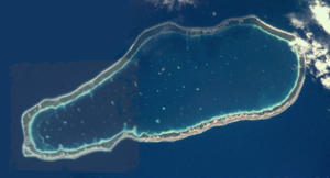
Atoll
An atoll is a coral island that encircles a lagoon partially or completely.- Usage :The word atoll comes from the Dhivehi word atholhu OED...
in the Tuamotu group in French Polynesia
French Polynesia
French Polynesia is an overseas country of the French Republic . It is made up of several groups of Polynesian islands, the most famous island being Tahiti in the Society Islands group, which is also the most populous island and the seat of the capital of the territory...
.
Length 17 km, width 6.4 km. Latitude 14° 42'; Longitude S 145° 15' W.
The nearest land is Takaroa
Takaroa
Takaroa, Taka-roa or Takapua, is an atoll in the Tuamotu group in French Polynesia. Length 27.4 km, width 7 km. Latitude 14° 27'; Longitude S 144° 59' W.The nearest land is Takapoto Atoll, located 10 km to the Southwest....
Atoll, located 10 km to the Northeast.
Takapoto's lagoon has a high salinity and a strong phytoplankton
Phytoplankton
Phytoplankton are the autotrophic component of the plankton community. The name comes from the Greek words φυτόν , meaning "plant", and πλαγκτός , meaning "wanderer" or "drifter". Most phytoplankton are too small to be individually seen with the unaided eye...
biomass.
Geographically Takapoto is part of the King George Islands
King George Islands
The King George Islands is a subgroup of the Tuamotus Archipelago group in French Polynesia.The King George Islands include four atolls and one island:* Ahe* Manihi* Takapoto* Takaroa* Tikei Island...
(Iles du Roi Georges) subgroup, which includes: Ahe
Ahe
Ahe, Ahemaru or Omaru, is an almost entirely-enclosed coral atoll, located in the northern Tuamotu Archipelago, just 14 km to the west of Manihi, in French Polynesia.Ahe Atoll's ring shape is broken by only a single small passage into the lagoon....
, Manihi
Manihi
Manihi, or Paeua, is a coral atoll in the Tuamotu Archipelago. It is one of the northernmost of the Tuamotus, located in the King George subgroup. The closest land to Manihi is Ahe Atoll, located 14 km to the west...
, Takapoto, Takaroa
Takaroa
Takaroa, Taka-roa or Takapua, is an atoll in the Tuamotu group in French Polynesia. Length 27.4 km, width 7 km. Latitude 14° 27'; Longitude S 144° 59' W.The nearest land is Takapoto Atoll, located 10 km to the Southwest....
and Tikei
Tikei
Tikei, also known as Manu, Tikai and Tiku is an island in the Tuamotu group in French Polynesia. Tikei is not a typical Tuamotu atoll, but a separate island. Maximum length: 2.8 Km, maximum width 1.2 Km...
.
Takapoto Atoll has 441 inhabitants. Fakatopatere, the main village on Takapoto, is located at the southern end of the atoll.
History
The first recorded European to sight Takapoto Atoll was Jacob Le MaireJacob Le Maire
Jacob Le Maire was a Dutch mariner who circumnavigated the earth in 1615-16. The strait between Tierra del Fuego and Isla de los Estados was named the Le Maire Strait in his honor, though not without controversy...
in 1616.
Takapoto Atoll was visited by the Charles Wilkes
Charles Wilkes
Charles Wilkes was an American naval officer and explorer. He led the United States Exploring Expedition, 1838-1842 and commanded the ship in the Trent Affair during the American Civil War...
expedition in September 1839.
Takapoto Airport was inaugurated in 1973.
Administration
The commune of Takaroa-Takapoto consists of the atolls of TakaroaTakaroa
Takaroa, Taka-roa or Takapua, is an atoll in the Tuamotu group in French Polynesia. Length 27.4 km, width 7 km. Latitude 14° 27'; Longitude S 144° 59' W.The nearest land is Takapoto Atoll, located 10 km to the Southwest....
and Takapoto, and Tikei
Tikei
Tikei, also known as Manu, Tikai and Tiku is an island in the Tuamotu group in French Polynesia. Tikei is not a typical Tuamotu atoll, but a separate island. Maximum length: 2.8 Km, maximum width 1.2 Km...
Island.