
Fatu Hiva
Encyclopedia
Fatu Hiva is the southernmost of the Marquesas Islands
, in French Polynesia
, an overseas territory of France
in the Pacific Ocean
. With Motu Nao
as its closest neighbor, it is also the most isolated of the inhabited islands.
Fatu Hiva is also the title of a book by explorer and archaeologist Thor Heyerdahl
, in which he describes his stay on the island in the 1930s.
is Fatu Iva (without "h": ˈfatu ˈiva). However, the name was recorded by Europeans as Fatu Hiva, perhaps under the influence of other Marquesan islands containing the element Hiva (Nuku Hiva
and Hiva Oa
) and also because in French
the letter "h" is silent
. The spelling Fatu Hiva has now become official.
The island was named Isla Magdalena ("Magdalene Island") by Spanish explorers in the 16th century, a name rarely used.
 The eastern coastline of Fatu Hiva is characterized by a number of narrow valleys, carved by streams that lead to the interior. Between these valleys are headlands which terminate in cliffs that plunge directly into the sea, making travel between them possible only by travelling over the high mountain ridges between them, or by boat. The largest of these valleys is at Uia
.
The western coastline has two significant bays, Hana Vave
(also known as Bay of Virgins or Baie des Vierges) in the north, one of the most picturesque sites in the South Pacific
, and the well protected harbor of Omoa
near the south. There are several smaller valleys between these two.
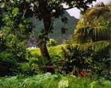
The center of the island is a plateau
which is covered largely by tall grasses and pandanus
trees. To the south of the plateau, running to the south, is a mountain ridge, called Tauauoho, its highest peak, at 1,125 m (3,691 ft.) is the highest point on Fatu Hiva. Proceeding to the north and northwest from the plateau is a mountain ridge called Fa‘e One, the highest peak of which is 820 m (2,690 ft.).
. This commune consists solely of the island of Fatu Hiva itself.
The administrative centre of the commune is the settlement of Omoa
, on the south-western side of the island.
Marquesas Islands
The Marquesas Islands enana and Te Fenua `Enata , both meaning "The Land of Men") are a group of volcanic islands in French Polynesia, an overseas collectivity of France in the southern Pacific Ocean. The Marquesas are located at 9° 00S, 139° 30W...
, in French Polynesia
French Polynesia
French Polynesia is an overseas country of the French Republic . It is made up of several groups of Polynesian islands, the most famous island being Tahiti in the Society Islands group, which is also the most populous island and the seat of the capital of the territory...
, an overseas territory of France
France
The French Republic , The French Republic , The French Republic , (commonly known as France , is a unitary semi-presidential republic in Western Europe with several overseas territories and islands located on other continents and in the Indian, Pacific, and Atlantic oceans. Metropolitan France...
in the Pacific Ocean
Pacific Ocean
The Pacific Ocean is the largest of the Earth's oceanic divisions. It extends from the Arctic in the north to the Southern Ocean in the south, bounded by Asia and Australia in the west, and the Americas in the east.At 165.2 million square kilometres in area, this largest division of the World...
. With Motu Nao
Motu Nao
Motu Nao is the Marquesan name for a small rock island in the southeastern Marquesas Islands, approximately northeast of Fatu Hiva. The French name for the island is Rocher Thomasset, which in English is Thomasset Rock....
as its closest neighbor, it is also the most isolated of the inhabited islands.
Fatu Hiva is also the title of a book by explorer and archaeologist Thor Heyerdahl
Thor Heyerdahl
Thor Heyerdahl was a Norwegian ethnographer and adventurer with a background in zoology and geography. He became notable for his Kon-Tiki expedition, in which he sailed by raft from South America to the Tuamotu Islands...
, in which he describes his stay on the island in the 1930s.
Name
The name of the island in MarquesanMarquesan language
Marquesan is a collection of East-Central Polynesian dialects, of the Marquesic group, spoken in the Marquesas Islands of French Polynesia. They are usually classified into two groups, North Marquesan and South Marquesan, roughly along geographic lines....
is Fatu Iva (without "h": ˈfatu ˈiva). However, the name was recorded by Europeans as Fatu Hiva, perhaps under the influence of other Marquesan islands containing the element Hiva (Nuku Hiva
Nuku Hiva
Nuku Hiva is the largest of the Marquesas Islands in French Polynesia, an overseas territory of France in the Pacific Ocean. It was formerly also known as Île Marchand and Madison Island....
and Hiva Oa
Hiva Oa
Hiva Oa is the second largest island in the Marquesas Islands, in French Polynesia, an overseas territory of France in the Pacific Ocean. It is the largest island of the Southern Marquesas group. According to local religion, the gods created the islands as their home. Therefore all islands have...
) and also because in French
French language
French is a Romance language spoken as a first language in France, the Romandy region in Switzerland, Wallonia and Brussels in Belgium, Monaco, the regions of Quebec and Acadia in Canada, and by various communities elsewhere. Second-language speakers of French are distributed throughout many parts...
the letter "h" is silent
Silent letter
In an alphabetic writing system, a silent letter is a letter that, in a particular word, does not correspond to any sound in the word's pronunciation...
. The spelling Fatu Hiva has now become official.
The island was named Isla Magdalena ("Magdalene Island") by Spanish explorers in the 16th century, a name rarely used.
Geography
Uia
Uia is the name of a narrow valley and small bay on the central eastern coast of Fatu Hiva.The well-watered valley, the largest on the east coast of the island, is about 1.3 km wide at its mouth, with steep ridges on all sides...
.
The western coastline has two significant bays, Hana Vave
Hana Vave
Hana Vave is the name of the northernmost bay on the west coast of Fatu Hiva. The bay is sometimes called the Bay of Virgins, a translation of the French name Baie des Vierges....
(also known as Bay of Virgins or Baie des Vierges) in the north, one of the most picturesque sites in the South Pacific
Pacific Islands
The Pacific Islands comprise 20,000 to 30,000 islands in the Pacific Ocean. The islands are also sometimes collectively called Oceania, although Oceania is sometimes defined as also including Australasia and the Malay Archipelago....
, and the well protected harbor of Omoa
Omo'a
Omo‘a is the name of a small town and valley at the head of a bay by the same name, on Fatu Hiva.The bay of Omo‘a is the southernmost bay on the western coast of Fatu Hiva, and provides a good anchorage. The village of Omo‘a was home to 247 inhabitants at the 2002 census. The village is home to...
near the south. There are several smaller valleys between these two.
The center of the island is a plateau
Plateau
In geology and earth science, a plateau , also called a high plain or tableland, is an area of highland, usually consisting of relatively flat terrain. A highly eroded plateau is called a dissected plateau...
which is covered largely by tall grasses and pandanus
Pandanus
Pandanus is a genus of monocots with about 600 known species. They are numerous palmlike dioecious trees and shrubs native of the Old World tropics and subtropics. They are classified in the order Pandanales, family Pandanaceae.-Overview:...
trees. To the south of the plateau, running to the south, is a mountain ridge, called Tauauoho, its highest peak, at 1,125 m (3,691 ft.) is the highest point on Fatu Hiva. Proceeding to the north and northwest from the plateau is a mountain ridge called Fa‘e One, the highest peak of which is 820 m (2,690 ft.).
Administration
Administratively Fatu Hiva forms the commune (municipality) of Fatu-Hiva, part of the administrative subdivision of the Marquesas IslandsMarquesas Islands
The Marquesas Islands enana and Te Fenua `Enata , both meaning "The Land of Men") are a group of volcanic islands in French Polynesia, an overseas collectivity of France in the southern Pacific Ocean. The Marquesas are located at 9° 00S, 139° 30W...
. This commune consists solely of the island of Fatu Hiva itself.
The administrative centre of the commune is the settlement of Omoa
Omo'a
Omo‘a is the name of a small town and valley at the head of a bay by the same name, on Fatu Hiva.The bay of Omo‘a is the southernmost bay on the western coast of Fatu Hiva, and provides a good anchorage. The village of Omo‘a was home to 247 inhabitants at the 2002 census. The village is home to...
, on the south-western side of the island.
Demographics
The 2007 population of Fatu Hiva was 587. The people live primarily in three villages:- Hana VaveHana VaveHana Vave is the name of the northernmost bay on the west coast of Fatu Hiva. The bay is sometimes called the Bay of Virgins, a translation of the French name Baie des Vierges....
- OmoaOmo'aOmo‘a is the name of a small town and valley at the head of a bay by the same name, on Fatu Hiva.The bay of Omo‘a is the southernmost bay on the western coast of Fatu Hiva, and provides a good anchorage. The village of Omo‘a was home to 247 inhabitants at the 2002 census. The village is home to...
- UiaUiaUia is the name of a narrow valley and small bay on the central eastern coast of Fatu Hiva.The well-watered valley, the largest on the east coast of the island, is about 1.3 km wide at its mouth, with steep ridges on all sides...