

Îles Saint-Marcouf
Encyclopedia
Îles Saint-Marcouf are a group of two small uninhabited islands off the coast of Normandy
, France
. They lie in the Baie de la Seine
region of the English Channel
and are 6.5 kilometres east of the coast of the Cotentin peninsula
at Ravenoville
and 13 kilometres from the island of Tatihou
and the harbour at Saint-Vaast-la-Hougue
. In addition to the fortifications (see below), there is a lighthouse, which dates to 1948, on the larger island.
The larger island, île du Large, is 500 metres east of the smaller île de Terre. They have a total area of 1,400 ha and a maximum altitude of 10 m.
The islands take their name from Saint Marcouf
, a saint who died on the Îles Saint-Marcouf on 1 May 588. There was a monastic presence on the islands until the 15th century.
the Royal Navy
the islands held the islands for nearly seven years as a strategic forward base. In July 1795 British sailors and marines
from the Western Frigate Squadron under the command of Captain Sir Sidney Smith
in occupied the islands. Smith dedicated several gunvessels, including , , , and , the latter purpose-built for the role, to provide materials and manpower for fortifying the islands and establishing a naval garrison. Royal Engineers helped in the construction of redoubts and shore batteries, which were manned by detachments of marines and Royal Artillery, which augmented the sailors. In December 1795 the crew of Shark mutinied, in part because of the harsh conditions on the islands, and handed her over to the French.
The islands served as a forward base for the blockade of Le Havre
, a launching point for intercepting coastal shipping, and as a transit point for French émigrés. A major attack on 7 May 1798 by French troops was repelled at the Battle of the Îles Saint-Marcouf
, with minimal British but heavy French casualties.
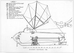 The islands almost made naval history in late 1800. On 12 September Robert Fulton
sailed his submarine the Nautilus
, to Growan, near Isigny-sur-Mer
, a small harbour near the islands. His objective was to use his submarine to attack the British gunvessels protecting the islands. He made two attempts, but each time his targets sailed before he could reach them. Then bad weather as winter approached prevented any further attempts. Although Fulton continued work on his concept, he never again threatened the islands.
; the last British forces left the islands in May 1802. Napoleon ordered the islands fortified and the work began in 1803. The primary defences consisted of a fort on Île du Large, 170 meters in diameter. The main structure is a circular fort with a diameter of 53 meters, with 48 firing ports for cannon on two levels of 24 casemate
s each. This work was completed by 1812. There are seven underground chambers and a cistern. The fort could accommodate 500 troops and this work was completed by 1812.
In 1840 a lighthouse was constructed within the fort. German forces destroyed it during World War II.
Later construction, between 1860 and 1867, added a quay, a powder magazine, and a semaphore station, the whole encircled with moats carved into the rock. In 1871, 200 Communards
from the Paris Commune
were incarcerated here in deplorable conditions. The total complex covers 2.5 hectares. The quay has since disappeared, reclaimed by the ocean.
On Île de Terre, the fortifications date to between 1849 and 1858. They consist of a shore battery and a guard house capable of housing some 60 troops. Neither island was ever attacked again, or at least not until the 20th Century.
the islands became the first French territory that seaborne Allied forces took on D-Day. At 04:30 on 6 June 1944 four US soldiers, armed only with knives, swam ashore from two-man canoes. When they had verified that the islands were unoccupied, 132 troops from 4th and 24th Squadrons of the U.S. 4th Cavalry Group landed on the islands to secure the approaches to Utah Beach
. Although they faced no resistance, the US troops suffered 19 casualties, killed and wounded, from mines that the Germans had left.
with restricted access. Île de Terre has been a designated nature preserve since 1967. Île du Large has been off-limits since 1991 for reasons of security. The primary bird species are seagulls and cormorants. In winter tens of thousands of seagulls shelter on the islands. Although access to the islands is forbidden, anchoring between them is permissible.
Currently, the fortifications are falling into ruins. Since 2003, the association "les Amis de l'île du Large Saint-Marcouf" (Friends of Saint-Marcouf), together with students from the Collège de Carentan
, have initiated a campaign to convince the authorities once again permit recreational access to the Île du Large. In 2009 the Friends of Saint-Marcouf received permission to commence preservation work on the fortifications and they have conducted three projects, the last in July 2011.(See: http://www.ilesaintmarcouf.com/ Website, in French, of "les Amis de l'île du Large Saint-Marcouf".)
Normandy
Normandy is a geographical region corresponding to the former Duchy of Normandy. It is in France.The continental territory covers 30,627 km² and forms the preponderant part of Normandy and roughly 5% of the territory of France. It is divided for administrative purposes into two régions:...
, France
France
The French Republic , The French Republic , The French Republic , (commonly known as France , is a unitary semi-presidential republic in Western Europe with several overseas territories and islands located on other continents and in the Indian, Pacific, and Atlantic oceans. Metropolitan France...
. They lie in the Baie de la Seine
Baie de la Seine
The Baie de la Seine or Baie de Seine is a bay in northern France.-Geography:It is a wide, rectangular inlet of the English Channel, approximately 100 kilometres by 45 kilometres, bounded in the west by the Cotentin Peninsula, in the south by the Normandy coast and in the east by the estuary of...
region of the English Channel
English Channel
The English Channel , often referred to simply as the Channel, is an arm of the Atlantic Ocean that separates southern England from northern France, and joins the North Sea to the Atlantic. It is about long and varies in width from at its widest to in the Strait of Dover...
and are 6.5 kilometres east of the coast of the Cotentin peninsula
Cotentin Peninsula
The Cotentin Peninsula, also known as the Cherbourg Peninsula, is a peninsula in Normandy, forming part of the north-western coast of France. It juts out north-westwards into the English Channel, towards Great Britain...
at Ravenoville
Ravenoville
Ravenoville is a commune in the Manche department in north-western France....
and 13 kilometres from the island of Tatihou
Tatihou
Tatihou is an island of Normandy in France with an area of 290,000 square metres. It is located to the east of the Cotentin peninsula just off the coast near Saint-Vaast-la-Hougue. It is almost uninhabited, and is usually reached by amphibious boat although, being a tidal island, it is also...
and the harbour at Saint-Vaast-la-Hougue
Saint-Vaast-la-Hougue
Saint-Vaast-la-Hougue is a commune in the Manche department in Normandy in north-western France.-Geography:Saint-Vaast-la-Hougue is situated in the Manche département, in the Basse-Normandie région. It is in the Quettehou canton, of the Cherbourg arrondissement. The town had a population of 2,097...
. In addition to the fortifications (see below), there is a lighthouse, which dates to 1948, on the larger island.
The larger island, île du Large, is 500 metres east of the smaller île de Terre. They have a total area of 1,400 ha and a maximum altitude of 10 m.
The islands take their name from Saint Marcouf
Saint Marcouf
Saint Marcouf , Abbot of Nantus in the Cotentin, is a saint born in the Saxon colony of Bayeux in Normandy around 500 AD and who is best known for the healing of scrofula....
, a saint who died on the Îles Saint-Marcouf on 1 May 588. There was a monastic presence on the islands until the 15th century.
British occupation
During the French Revolutionary WarsFrench Revolutionary Wars
The French Revolutionary Wars were a series of major conflicts, from 1792 until 1802, fought between the French Revolutionary government and several European states...
the Royal Navy
Royal Navy
The Royal Navy is the naval warfare service branch of the British Armed Forces. Founded in the 16th century, it is the oldest service branch and is known as the Senior Service...
the islands held the islands for nearly seven years as a strategic forward base. In July 1795 British sailors and marines
Royal Marines
The Corps of Her Majesty's Royal Marines, commonly just referred to as the Royal Marines , are the marine corps and amphibious infantry of the United Kingdom and, along with the Royal Navy and Royal Fleet Auxiliary, form the Naval Service...
from the Western Frigate Squadron under the command of Captain Sir Sidney Smith
Sidney Smith (admiral)
Admiral Sir William Sidney Smith, KCB, GCTE was a British naval officer. Serving in the American and French revolutionary wars, he later rose to the rank of admiral....
in occupied the islands. Smith dedicated several gunvessels, including , , , and , the latter purpose-built for the role, to provide materials and manpower for fortifying the islands and establishing a naval garrison. Royal Engineers helped in the construction of redoubts and shore batteries, which were manned by detachments of marines and Royal Artillery, which augmented the sailors. In December 1795 the crew of Shark mutinied, in part because of the harsh conditions on the islands, and handed her over to the French.
The islands served as a forward base for the blockade of Le Havre
Le Havre
Le Havre is a city in the Seine-Maritime department of the Haute-Normandie region in France. It is situated in north-western France, on the right bank of the mouth of the river Seine on the English Channel. Le Havre is the most populous commune in the Haute-Normandie region, although the total...
, a launching point for intercepting coastal shipping, and as a transit point for French émigrés. A major attack on 7 May 1798 by French troops was repelled at the Battle of the Îles Saint-Marcouf
Battle of the Îles Saint-Marcouf
The Battle of the Îles Saint-Marcouf was an engagement fought off the Îles Saint-Marcouf near the Cotentin peninsula on the Normandy coast of France in May 1798 during the French Revolutionary Wars. In 1795 a British garrison was placed on the islands, which operated as a resupply base for Royal...
, with minimal British but heavy French casualties.
Robert Fulton
Robert Fulton was an American engineer and inventor who is widely credited with developing the first commercially successful steamboat...
sailed his submarine the Nautilus
Nautilus (1800 submarine)
Nautilus, first tested in 1800, is often considered the first practical submarine, though preceded by Cornelius Drebbel's of 1620.-Background:...
, to Growan, near Isigny-sur-Mer
Isigny-sur-Mer
Isigny-sur-Mer is a commune in the Calvados department in the Basse-Normandie region in northwestern France.-Geography:Positioned at the bottom of the baie des Veys, Isigny is an important milk production area, known for its AOC butter and cream, as well as its cheeses made by the Isigny Sainte...
, a small harbour near the islands. His objective was to use his submarine to attack the British gunvessels protecting the islands. He made two attempts, but each time his targets sailed before he could reach them. Then bad weather as winter approached prevented any further attempts. Although Fulton continued work on his concept, he never again threatened the islands.
French control
The British returned the islands to France under the terms of Article 3 of the 1802 Treaty of AmiensTreaty of Amiens
The Treaty of Amiens temporarily ended hostilities between the French Republic and the United Kingdom during the French Revolutionary Wars. It was signed in the city of Amiens on 25 March 1802 , by Joseph Bonaparte and the Marquess Cornwallis as a "Definitive Treaty of Peace"...
; the last British forces left the islands in May 1802. Napoleon ordered the islands fortified and the work began in 1803. The primary defences consisted of a fort on Île du Large, 170 meters in diameter. The main structure is a circular fort with a diameter of 53 meters, with 48 firing ports for cannon on two levels of 24 casemate
Casemate
A casemate, sometimes rendered casement, is a fortified gun emplacement or armored structure from which guns are fired. originally a vaulted chamber in a fortress.-Origin of the term:...
s each. This work was completed by 1812. There are seven underground chambers and a cistern. The fort could accommodate 500 troops and this work was completed by 1812.
In 1840 a lighthouse was constructed within the fort. German forces destroyed it during World War II.
Later construction, between 1860 and 1867, added a quay, a powder magazine, and a semaphore station, the whole encircled with moats carved into the rock. In 1871, 200 Communards
Communards
The Communards were members and supporters of the short-lived 1871 Paris Commune formed in the wake of the Franco-Prussian War and France's defeat....
from the Paris Commune
Paris Commune
The Paris Commune was a government that briefly ruled Paris from March 18 to May 28, 1871. It existed before the split between anarchists and Marxists had taken place, and it is hailed by both groups as the first assumption of power by the working class during the Industrial Revolution...
were incarcerated here in deplorable conditions. The total complex covers 2.5 hectares. The quay has since disappeared, reclaimed by the ocean.
On Île de Terre, the fortifications date to between 1849 and 1858. They consist of a shore battery and a guard house capable of housing some 60 troops. Neither island was ever attacked again, or at least not until the 20th Century.
World War II
In World War IIWorld War II
World War II, or the Second World War , was a global conflict lasting from 1939 to 1945, involving most of the world's nations—including all of the great powers—eventually forming two opposing military alliances: the Allies and the Axis...
the islands became the first French territory that seaborne Allied forces took on D-Day. At 04:30 on 6 June 1944 four US soldiers, armed only with knives, swam ashore from two-man canoes. When they had verified that the islands were unoccupied, 132 troops from 4th and 24th Squadrons of the U.S. 4th Cavalry Group landed on the islands to secure the approaches to Utah Beach
Utah Beach
Utah Beach was the code name for the right flank, or westernmost, of the Allied landing beaches during the D-Day invasion of Normandy, as part of Operation Overlord on 6 June 1944...
. Although they faced no resistance, the US troops suffered 19 casualties, killed and wounded, from mines that the Germans had left.
Nature reserve
The islands are directly administered by the French government, and form a protected nature reserveNature reserve
A nature reserve is a protected area of importance for wildlife, flora, fauna or features of geological or other special interest, which is reserved and managed for conservation and to provide special opportunities for study or research...
with restricted access. Île de Terre has been a designated nature preserve since 1967. Île du Large has been off-limits since 1991 for reasons of security. The primary bird species are seagulls and cormorants. In winter tens of thousands of seagulls shelter on the islands. Although access to the islands is forbidden, anchoring between them is permissible.
Currently, the fortifications are falling into ruins. Since 2003, the association "les Amis de l'île du Large Saint-Marcouf" (Friends of Saint-Marcouf), together with students from the Collège de Carentan
Carentan
Carentan is a small rural town near the north-eastern base of the French Cotentin Peninsula in Normandy in north-western France near the port city of Cherbourg-Octeville. Carentan has a population somewhat over 6,000 and is now administratively organized as a commune in the Manche department...
, have initiated a campaign to convince the authorities once again permit recreational access to the Île du Large. In 2009 the Friends of Saint-Marcouf received permission to commence preservation work on the fortifications and they have conducted three projects, the last in July 2011.(See: http://www.ilesaintmarcouf.com/ Website, in French, of "les Amis de l'île du Large Saint-Marcouf".)
Sources
- Flexner, James Thomas (1993) Steamboats come true: American inventors in action. (Fordham Univ Press).
- Laws, Lt. Col. M.E.S. "The Defence of St. Marcouf", Journal of the Royal Artillery, Vol. 75, No. 4, pp.298-307.(Pdf version) (http://freepages.genealogy.rootsweb.ancestry.com/~pbtyc/Naval_History/Vol_II/P_114.html)
Further reading
- Gérard Morizot — Histoire des îles Saint-Marcouf en Cotentin, jusqu'au XIXe siècle ISBN 2-9516531-0-7