
Washington State Route 25
Encyclopedia
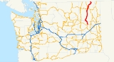
State Route 25 named the Coulee Reservoir Highway, is a 121.17 miles (195 km) long state highway
serving communities in Lincoln and Stevens counties in the U.S. state of Washington. The highway begins at an intersection with (US 2) east of Davenport
and continues northwest to cross the Spokane River
on the Spokane River Bridge. From the bridge, SR 25 parallels the Columbia River
and Franklin D. Roosevelt Lake
upstream through several small communities, passing the Gifford–Inchelium Ferry, to Kettle Falls
. In Kettle Falls, the roadway intersects , co-signed with and continues north to Northport
, where former is intersected and SR 25 crosses the Columbia River
on the Northport Bridge
. The highway travels northwest to the Canadian border, where it becomes (BC 22).
SR 25 was originally a series of county roads built before 1912, but became part of the Inland Empire Highway in 1913 between Meyers Falls, now known as Kettle Falls, and Northport
. In 1915, the highway was realigned west and roads from Davenport to Meyers Falls became State Road 22 (SR 22), which was extended north to Canada in 1931. In 1937, SR 22 became Primary State Highway 22 (PSH 22) and the border crossing
was moved west of the Columbia River. PSH 22 was decommissioned in favor of SR 25 in a state highway renumbering in 1964. SR 25 also had an auxiliary route
, , that existed from 1964 until 1983 and ran north from Northport to the Canadian border at Boundary.
SR 25 crosses the Spokane and Columbia rivers on the Spokane River Bridge and Columbia River Bridge, respectively. The Spokane River Bridge was built in 1941 to replace an earlier span, known as the Detillion Bridge, that was flooded by Franklin D. Roosevelt Lake. The Columbia River Bridge was completed in 1951 to serve the town of Northport. Both bridges are steel cantilever
spans that were inducted onto the National Register of Historic Places
in 1995. The Gifford–Inchelium Ferry that connects the highway to Inchelium
began operating in 1898, but was closed from 1974 until 1981, when the Colville Confederated Tribes began operating the MV Columbian Princess with a free fare.
and the eastern terminus of . The highway travels northwest through farmland and grasslands in rural Lincoln County. Near Fort Spokane, part of Lake Roosevelt National Recreation Area
, From Fort Spokane, the roadway travels over the Spokane River
on the Spokane River Bridge, a steel cantilever
span built in 1941 to replace an older bridge that was flooded by Franklin D. Roosevelt Lake
, into Stevens County. From the bridge, SR 25 turns northeast, paralleling the Columbia River
upstream through Hunters
and Cedonia
to Gifford. At Gifford, the highway serves as eastern terminus of the Gifford–Inchelium Ferry that travels across the Columbia River to the community of Inchelium
in Ferry County and is owned by the Colville Confederated Tribes
. There isn't a fare for the ferry, named the MV Columbia Princess, and it runs daily every 15 minutes from 6:30am to 10:45pm. From the ferry, the road continues north through forests and the community of Rice to Kettle Falls
. West of Kettle Falls, SR 25 passes under an overpass
used by the Kettle Falls–Grand Forks, BC
route operated by the Kettle Falls International Railway
.
Immediately north of the overpass, the highway intersects (US 395), co-signed with . From the intersection, the roadway continues northeast paralleling the Columbia River and the Kettle Falls–Columbia Gardens, BC route of the Kettle Falls International Railway through Marcus
and Ryan
to Northport
. In Northport, the highway becomes Center Street and travels through the city center before intersecting the Northport–Boundary Road, which was formerly until 1983. Center Street ends and SR 25 turns northwest to cross the Columbia River on the Northport Bridge
, a steel cantilever span built in 1951. From the bridge, the highway travels north and rapidly turns west and reverts back to north towards the Canadian border. The road is named Little Sheep Creek Road and crosses into Canada as (BC 22) to a customs
checkpoint
.
 SR 25 began as a series of county roads connecting small communities on the Columbia River
that were constructed between 1909 and 1912. In 1913, the Inland Empire Highway was established and included a segment from Meyers Falls, currently known as Kettle Falls
, to the Canadian border at Boundary was included. The Inland Empire Highway was shifted west in 1915 and several roads from Meyers Falls to Davenport
became State Road 22 (SR 22) and crossed the Spokane River
with the Detillion Bridge. SR 22 remained unchanged through a 1923 restructuring of the state road system, but was extended north to the Canadian border at Boundary in 1931. In 1937, SR 22 became (PSH 22) and the northern terminus was realigned to end northwest of Northport
, while the old route became (SSH 22A). Washington renumbered its highways in 1964 to correspond to a new sign route, later state route, system. PSH 22 became SR 25 and SSH 22A became , an auxiliary route
of SR 25. SR 251 was later removed from the state highway system in 1983.
 The Spokane River Bridge, successor of the Detillion Bridge, was opened in 1941 to replace the span, which was flooded by Franklin D. Roosevelt Lake
. A bridge across the Columbia River at Northport began construction in 1949 and was completed as the Columbia River Bridge on June 13, 1951. On March 28, 1995, the Spokane River Bridge at Fort Spokane was listed on the National Register of Historic Places
and was joined by the Columbia River Bridge at Northport on May 24, 1995.
A ferry between Inchelium
and SR 25 at Gifford on the Columbia River has operated since 1898 under various owners and with various vessels. In 1898, the ferry was first opened to public traffic, a result of a Congressional decision to open up the Colville Indian Reservation
to mineral mining. When Franklin D. Roosevelt Lake was created after the Grand Coulee Dam
was built in 1941, the ferry was moved to higher ground. Ferry service remained privately-owned until 1974, when it was closed due to low traffic. In 1981, the Colville Confederated Tribes and United States Bureau of Indian Affairs began a new ferry service with the MV Columbian Princess and continues to the present.
!County
!Location
!Mile
!Destinations
!Notes
|-
|Lincoln
|Davenport
|0.00
|
|Southern terminus
|-
|rowspan=3|Stevens
|Kettle Falls
|81.07
|, Grand Forks, BC
|
|-
|Northport
|113.67
|Northport–Boundary Road
|Former SR 251
|-
|
|121.17
|
|Canada – United States border
SR 251 was a 10.86 miles (17.48 km) long highway that ran from Northport
, paralleling the Columbia River
and a rail line operated by Kettle Falls International Railway
, to the Canadian border at Boundary. Originally county roads until 1912, the general route became part of the Inland Empire Highway from 1913 until removal from state maintenance in 1915. The roadway became state-maintained again when State Road 22 was extended north to Canada in 1931. In 1937, the extension became , which later was designated as SR 251 from 1964 until 1983. The roadway is now known as the Northport–Boundary Highway and continues to be maintained by Stevens County.
State highways in Washington
In the U.S. state of Washington, the Washington State Department of Transportation maintains a network of over 7000 miles of state highways, including all Interstate and U.S. Highways that pass through the state. The system comprises 8.5% of the state's public road mileage, but carries over half...
serving communities in Lincoln and Stevens counties in the U.S. state of Washington. The highway begins at an intersection with (US 2) east of Davenport
Davenport, Washington
Davenport is a city in Lincoln County, Washington, United States. The population was 1,734 at the 2010 census. It is the county seat of Lincoln County.-History:Davenport was first settled in 1880, and was named in 1882 for resident J.C. Davenport...
and continues northwest to cross the Spokane River
Spokane River
The Spokane River is a tributary of the Columbia River, approximately long, in northern Idaho and eastern Washington in the United States. It drains a low mountainous area east of the Columbia, passing through the city of Spokane, Washington.-Description:...
on the Spokane River Bridge. From the bridge, SR 25 parallels the Columbia River
Columbia River
The Columbia River is the largest river in the Pacific Northwest region of North America. The river rises in the Rocky Mountains of British Columbia, Canada, flows northwest and then south into the U.S. state of Washington, then turns west to form most of the border between Washington and the state...
and Franklin D. Roosevelt Lake
Franklin D. Roosevelt Lake
Franklin D. Roosevelt Lake is the reservoir created in 1941 by the impoundment of the Columbia River by the Grand Coulee Dam in Washington state. It is named for Franklin D. Roosevelt, who was President during the construction of the dam...
upstream through several small communities, passing the Gifford–Inchelium Ferry, to Kettle Falls
Kettle Falls, Washington
Kettle Falls is a city in Stevens County, Washington, United States, named for the nearby Kettle Falls on the Columbia River, an ancient and important fishing site for Native Americans...
. In Kettle Falls, the roadway intersects , co-signed with and continues north to Northport
Northport, Washington
Northport is a town in Stevens County, Washington, United States. The population was 295 at the 2010 census.-History:Northport was given its name since it was once the northernmost town on the Spokane Falls and Northern Railway...
, where former is intersected and SR 25 crosses the Columbia River
Columbia River
The Columbia River is the largest river in the Pacific Northwest region of North America. The river rises in the Rocky Mountains of British Columbia, Canada, flows northwest and then south into the U.S. state of Washington, then turns west to form most of the border between Washington and the state...
on the Northport Bridge
Northport Bridge
The Northport Bridge spans the Columbia River near Northport, Washington, close to the border with Canada. The steel cantilever through-truss bridge replaced an 1897 timber bridge, and was completed in 1951. It carries Washington State Route 25...
. The highway travels northwest to the Canadian border, where it becomes (BC 22).
SR 25 was originally a series of county roads built before 1912, but became part of the Inland Empire Highway in 1913 between Meyers Falls, now known as Kettle Falls, and Northport
Northport, Washington
Northport is a town in Stevens County, Washington, United States. The population was 295 at the 2010 census.-History:Northport was given its name since it was once the northernmost town on the Spokane Falls and Northern Railway...
. In 1915, the highway was realigned west and roads from Davenport to Meyers Falls became State Road 22 (SR 22), which was extended north to Canada in 1931. In 1937, SR 22 became Primary State Highway 22 (PSH 22) and the border crossing
Border Crossing
Border Crossing may refer to:* Border Crossing , an album by saxophonist Mike Osborne.* Border Crossing , a UK hip hop collective musical group.* Border Crossing , a 2001 novel by English author Pat Barker....
was moved west of the Columbia River. PSH 22 was decommissioned in favor of SR 25 in a state highway renumbering in 1964. SR 25 also had an auxiliary route
Auxiliary route
In road transportation, a special route is a prefixed and/or suffixed numbered road that forms a loop or spur of a more dominant route of the same route number and system. The dominant route is generally referred to as the "parent" or "mainline", while special routes are also unofficially or...
, , that existed from 1964 until 1983 and ran north from Northport to the Canadian border at Boundary.
SR 25 crosses the Spokane and Columbia rivers on the Spokane River Bridge and Columbia River Bridge, respectively. The Spokane River Bridge was built in 1941 to replace an earlier span, known as the Detillion Bridge, that was flooded by Franklin D. Roosevelt Lake. The Columbia River Bridge was completed in 1951 to serve the town of Northport. Both bridges are steel cantilever
Cantilever bridge
A cantilever bridge is a bridge built using cantilevers, structures that project horizontally into space, supported on only one end. For small footbridges, the cantilevers may be simple beams; however, large cantilever bridges designed to handle road or rail traffic use trusses built from...
spans that were inducted onto the National Register of Historic Places
National Register of Historic Places
The National Register of Historic Places is the United States government's official list of districts, sites, buildings, structures, and objects deemed worthy of preservation...
in 1995. The Gifford–Inchelium Ferry that connects the highway to Inchelium
Inchelium, Washington
Inchelium is a census-designated place in Ferry County, Washington, United States on the Colville Indian Reservation. The population was 409 at the 2010 census....
began operating in 1898, but was closed from 1974 until 1981, when the Colville Confederated Tribes began operating the MV Columbian Princess with a free fare.
Route description
SR 25, named the Coulee Reservoir Highway, begins at an intersection with (US 2) east of DavenportDavenport, Washington
Davenport is a city in Lincoln County, Washington, United States. The population was 1,734 at the 2010 census. It is the county seat of Lincoln County.-History:Davenport was first settled in 1880, and was named in 1882 for resident J.C. Davenport...
and the eastern terminus of . The highway travels northwest through farmland and grasslands in rural Lincoln County. Near Fort Spokane, part of Lake Roosevelt National Recreation Area
Lake Roosevelt National Recreation Area
Lake Roosevelt National Recreation Area is a U.S. National Recreation Area of the National Park Service that encompasses the long Franklin D. Roosevelt Lake between Grand Coulee Dam and Northport, Washington, in eastern Washington state. It is a popular boating, fishing, hunting, camping, and...
, From Fort Spokane, the roadway travels over the Spokane River
Spokane River
The Spokane River is a tributary of the Columbia River, approximately long, in northern Idaho and eastern Washington in the United States. It drains a low mountainous area east of the Columbia, passing through the city of Spokane, Washington.-Description:...
on the Spokane River Bridge, a steel cantilever
Cantilever bridge
A cantilever bridge is a bridge built using cantilevers, structures that project horizontally into space, supported on only one end. For small footbridges, the cantilevers may be simple beams; however, large cantilever bridges designed to handle road or rail traffic use trusses built from...
span built in 1941 to replace an older bridge that was flooded by Franklin D. Roosevelt Lake
Franklin D. Roosevelt Lake
Franklin D. Roosevelt Lake is the reservoir created in 1941 by the impoundment of the Columbia River by the Grand Coulee Dam in Washington state. It is named for Franklin D. Roosevelt, who was President during the construction of the dam...
, into Stevens County. From the bridge, SR 25 turns northeast, paralleling the Columbia River
Columbia River
The Columbia River is the largest river in the Pacific Northwest region of North America. The river rises in the Rocky Mountains of British Columbia, Canada, flows northwest and then south into the U.S. state of Washington, then turns west to form most of the border between Washington and the state...
upstream through Hunters
Hunters, Washington
Hunters is an unincorporate community in Stevens County, Washington, United States. The population for its zip code was 306 at the 2000 census.-Demographics:As of the census of 2000, there were 306 people, and 135 households residing in the zip code...
and Cedonia
Cedonia, Washington
Cedonia is a very small unincorporated village in Stevens County, Washington, United States. It lies along the Columbia River, at a section that is known as Lake Roosevelt, a reservoir created by Grand Coulee Dam. The area surrounding it is primarily a farming and ranching community with some...
to Gifford. At Gifford, the highway serves as eastern terminus of the Gifford–Inchelium Ferry that travels across the Columbia River to the community of Inchelium
Inchelium, Washington
Inchelium is a census-designated place in Ferry County, Washington, United States on the Colville Indian Reservation. The population was 409 at the 2010 census....
in Ferry County and is owned by the Colville Confederated Tribes
Colville Indian Reservation
The Colville Indian Reservation is an Indian reservation in the north-central part of the U.S. state of Washington, inhabited and managed by the Confederated Tribes of the Colville Reservation, which is recognized by the United States of America as an American Indian Tribe...
. There isn't a fare for the ferry, named the MV Columbia Princess, and it runs daily every 15 minutes from 6:30am to 10:45pm. From the ferry, the road continues north through forests and the community of Rice to Kettle Falls
Kettle Falls, Washington
Kettle Falls is a city in Stevens County, Washington, United States, named for the nearby Kettle Falls on the Columbia River, an ancient and important fishing site for Native Americans...
. West of Kettle Falls, SR 25 passes under an overpass
Overpass
An overpass is a bridge, road, railway or similar structure that crosses over another road or railway...
used by the Kettle Falls–Grand Forks, BC
Grand Forks, British Columbia
-Schools:Schools in the region are operated by School District 51 Boundary which has its main office in Grand Forks but also serves Midway, Greenwood, Beaverdell, and Rock Creek....
route operated by the Kettle Falls International Railway
Kettle Falls International Railway
The Kettle Falls International Railway is a railroad operating in the U.S. state of Washington and the Canadian province of British Columbia. It operates approximately of track that was formerly owned by the Burlington Northern and Santa Fe Railway. It is owned by OmniTRAX.- Route :The railroad...
.
Immediately north of the overpass, the highway intersects (US 395), co-signed with . From the intersection, the roadway continues northeast paralleling the Columbia River and the Kettle Falls–Columbia Gardens, BC route of the Kettle Falls International Railway through Marcus
Marcus, Washington
Marcus is a town in Stevens County, Washington, United States. The population was 117 at the 2000 census and 183 at the 2010 census, a 56.4% increase over the 2000 census.-History:Marcus was named for Marcus Oppenheimer who settled in the area in 1863....
and Ryan
Ryan, Washington
Ryan is a populated place in Stevens County, Washington, United States. The name was collected by the United States Geological Survey between 1976 and 1979, and entered into the Geographic Names Information System on September 10, 1979....
to Northport
Northport, Washington
Northport is a town in Stevens County, Washington, United States. The population was 295 at the 2010 census.-History:Northport was given its name since it was once the northernmost town on the Spokane Falls and Northern Railway...
. In Northport, the highway becomes Center Street and travels through the city center before intersecting the Northport–Boundary Road, which was formerly until 1983. Center Street ends and SR 25 turns northwest to cross the Columbia River on the Northport Bridge
Northport Bridge
The Northport Bridge spans the Columbia River near Northport, Washington, close to the border with Canada. The steel cantilever through-truss bridge replaced an 1897 timber bridge, and was completed in 1951. It carries Washington State Route 25...
, a steel cantilever span built in 1951. From the bridge, the highway travels north and rapidly turns west and reverts back to north towards the Canadian border. The road is named Little Sheep Creek Road and crosses into Canada as (BC 22) to a customs
Customs
Customs is an authority or agency in a country responsible for collecting and safeguarding customs duties and for controlling the flow of goods including animals, transports, personal effects and hazardous items in and out of a country...
checkpoint
Border checkpoint
A border checkpoint is a place, generally between two countries, where travellers and/or goods are inspected. Authorization often is required to enter a country through its borders. Access-controlled borders often have a limited number of checkpoints where they can be crossed without legal...
.
History
Columbia River
The Columbia River is the largest river in the Pacific Northwest region of North America. The river rises in the Rocky Mountains of British Columbia, Canada, flows northwest and then south into the U.S. state of Washington, then turns west to form most of the border between Washington and the state...
that were constructed between 1909 and 1912. In 1913, the Inland Empire Highway was established and included a segment from Meyers Falls, currently known as Kettle Falls
Kettle Falls, Washington
Kettle Falls is a city in Stevens County, Washington, United States, named for the nearby Kettle Falls on the Columbia River, an ancient and important fishing site for Native Americans...
, to the Canadian border at Boundary was included. The Inland Empire Highway was shifted west in 1915 and several roads from Meyers Falls to Davenport
Davenport, Washington
Davenport is a city in Lincoln County, Washington, United States. The population was 1,734 at the 2010 census. It is the county seat of Lincoln County.-History:Davenport was first settled in 1880, and was named in 1882 for resident J.C. Davenport...
became State Road 22 (SR 22) and crossed the Spokane River
Spokane River
The Spokane River is a tributary of the Columbia River, approximately long, in northern Idaho and eastern Washington in the United States. It drains a low mountainous area east of the Columbia, passing through the city of Spokane, Washington.-Description:...
with the Detillion Bridge. SR 22 remained unchanged through a 1923 restructuring of the state road system, but was extended north to the Canadian border at Boundary in 1931. In 1937, SR 22 became (PSH 22) and the northern terminus was realigned to end northwest of Northport
Northport, Washington
Northport is a town in Stevens County, Washington, United States. The population was 295 at the 2010 census.-History:Northport was given its name since it was once the northernmost town on the Spokane Falls and Northern Railway...
, while the old route became (SSH 22A). Washington renumbered its highways in 1964 to correspond to a new sign route, later state route, system. PSH 22 became SR 25 and SSH 22A became , an auxiliary route
Auxiliary route
In road transportation, a special route is a prefixed and/or suffixed numbered road that forms a loop or spur of a more dominant route of the same route number and system. The dominant route is generally referred to as the "parent" or "mainline", while special routes are also unofficially or...
of SR 25. SR 251 was later removed from the state highway system in 1983.
Franklin D. Roosevelt Lake
Franklin D. Roosevelt Lake is the reservoir created in 1941 by the impoundment of the Columbia River by the Grand Coulee Dam in Washington state. It is named for Franklin D. Roosevelt, who was President during the construction of the dam...
. A bridge across the Columbia River at Northport began construction in 1949 and was completed as the Columbia River Bridge on June 13, 1951. On March 28, 1995, the Spokane River Bridge at Fort Spokane was listed on the National Register of Historic Places
National Register of Historic Places
The National Register of Historic Places is the United States government's official list of districts, sites, buildings, structures, and objects deemed worthy of preservation...
and was joined by the Columbia River Bridge at Northport on May 24, 1995.
A ferry between Inchelium
Inchelium, Washington
Inchelium is a census-designated place in Ferry County, Washington, United States on the Colville Indian Reservation. The population was 409 at the 2010 census....
and SR 25 at Gifford on the Columbia River has operated since 1898 under various owners and with various vessels. In 1898, the ferry was first opened to public traffic, a result of a Congressional decision to open up the Colville Indian Reservation
Colville Indian Reservation
The Colville Indian Reservation is an Indian reservation in the north-central part of the U.S. state of Washington, inhabited and managed by the Confederated Tribes of the Colville Reservation, which is recognized by the United States of America as an American Indian Tribe...
to mineral mining. When Franklin D. Roosevelt Lake was created after the Grand Coulee Dam
Grand Coulee Dam
Grand Coulee Dam is a gravity dam on the Columbia River in the U.S. state of Washington built to produce hydroelectric power and provide irrigation. It was constructed between 1933 and 1942, originally with two power plants. A third power station was completed in 1974 to increase its energy...
was built in 1941, the ferry was moved to higher ground. Ferry service remained privately-owned until 1974, when it was closed due to low traffic. In 1981, the Colville Confederated Tribes and United States Bureau of Indian Affairs began a new ferry service with the MV Columbian Princess and continues to the present.
Major intersections
{| class=wikitable!County
!Location
!Mile
!Destinations
!Notes
|-
|Lincoln
|Davenport
Davenport, Washington
Davenport is a city in Lincoln County, Washington, United States. The population was 1,734 at the 2010 census. It is the county seat of Lincoln County.-History:Davenport was first settled in 1880, and was named in 1882 for resident J.C. Davenport...
|0.00
|
|Southern terminus
|-
|rowspan=3|Stevens
|Kettle Falls
Kettle Falls, Washington
Kettle Falls is a city in Stevens County, Washington, United States, named for the nearby Kettle Falls on the Columbia River, an ancient and important fishing site for Native Americans...
|81.07
|, Grand Forks, BC
Grand Forks, British Columbia
-Schools:Schools in the region are operated by School District 51 Boundary which has its main office in Grand Forks but also serves Midway, Greenwood, Beaverdell, and Rock Creek....
|
|-
|Northport
Northport, Washington
Northport is a town in Stevens County, Washington, United States. The population was 295 at the 2010 census.-History:Northport was given its name since it was once the northernmost town on the Spokane Falls and Northern Railway...
|113.67
|Northport–Boundary Road
|Former SR 251
Washington State Route 251
State Route 251 is a former long state highway in Stevens County, Washington. The highway began at in Northport and continued northeast parallel to the Columbia River to Boundary, an unincorporated community, where it crossed the Canada – United States border into British Columbia as...
|-
|
|121.17
|
|Canada – United States border
Related routes
Three digit state highway numbers are considered auxiliary routes of their one or two digit parent route, thus SR 25 has one decommissioned auxiliary route, .SR 251 was a 10.86 miles (17.48 km) long highway that ran from Northport
Northport, Washington
Northport is a town in Stevens County, Washington, United States. The population was 295 at the 2010 census.-History:Northport was given its name since it was once the northernmost town on the Spokane Falls and Northern Railway...
, paralleling the Columbia River
Columbia River
The Columbia River is the largest river in the Pacific Northwest region of North America. The river rises in the Rocky Mountains of British Columbia, Canada, flows northwest and then south into the U.S. state of Washington, then turns west to form most of the border between Washington and the state...
and a rail line operated by Kettle Falls International Railway
Kettle Falls International Railway
The Kettle Falls International Railway is a railroad operating in the U.S. state of Washington and the Canadian province of British Columbia. It operates approximately of track that was formerly owned by the Burlington Northern and Santa Fe Railway. It is owned by OmniTRAX.- Route :The railroad...
, to the Canadian border at Boundary. Originally county roads until 1912, the general route became part of the Inland Empire Highway from 1913 until removal from state maintenance in 1915. The roadway became state-maintained again when State Road 22 was extended north to Canada in 1931. In 1937, the extension became , which later was designated as SR 251 from 1964 until 1983. The roadway is now known as the Northport–Boundary Highway and continues to be maintained by Stevens County.