

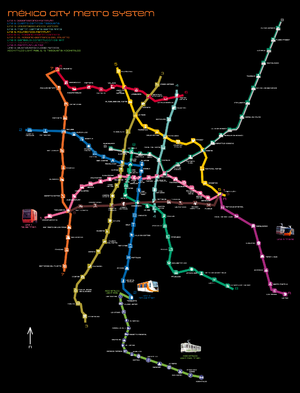
List of Mexico City metro stations
Encyclopedia
Mexico City Metro
The Mexico City Metro , officially called Sistema de Transporte Colectivo, is a metro system that serves the metropolitan area of Mexico City...
system, , organized by number. The order in which they are listed follows the convention used by Sistema de Transporte Colectivo (the public company
Public company
This is not the same as a Government-owned corporation.A public company or publicly traded company is a limited liability company that offers its securities for sale to the general public, typically through a stock exchange, or through market makers operating in over the counter markets...
that manages the system) to list the stations in north-south and west-east fashion. This system however may not be used by other sources.
In addition to listing all current 175 stations, the opening date of each one of them is also provided, including their type of construction, which can fit in one of three categories: underground, surface ("street-level") and elevated (in form of an elevated viaduct
Viaduct
A viaduct is a bridge composed of several small spans. The term viaduct is derived from the Latin via for road and ducere to lead something. However, the Ancient Romans did not use that term per se; it is a modern derivation from an analogy with aqueduct. Like the Roman aqueducts, many early...
). In total, 107 stations are under ground, 52 are located on street-level and 16 are elevated.
Line 1

Mexico City Metro Line 1
Mexico City Metro Line 1 is one of the 16 metro lines built in Mexico City, Mexico. It was the first to be built, the identifying color is pink and runs through the city from west to east....
was the first to be opened in the system, in 1969. After four expansions, the line currently has 20 stations over a total track length of 18.828 km, of which 16.654 km are passenger track. The line has a general east-west direction passing through the city center and its color is pink
Pink
Pink is a mixture of red and white. Commonly used for Valentine's Day and Easter, pink is sometimes referred to as "the color of love." The use of the word for the color known today as pink was first recorded in the late 17th century....
.
It is the only line in the system where all stations run underground, and although a section of the track past the Observatorio terminal is located on the street-level, it is only used for train maintenance. Six stations connect with other metro lines. Line 1 is served by MP-68 trains, built in France in 1968 and NE-92 trains, built in Spain in 1992.
The line is built under several avenues: Parque Lira, Pedro Antonio de los Santos, Circuito Interior, Avenida de los Insurgentes
Avenida de los Insurgentes
Avenida de los Insurgentes , sometimes known simply as Insurgentes, is the longest avenue in Mexico City and said to be the longest in the world with a length of on a north-south axis across the city...
, Avenida Chapultepec, Arcos de Belén, Balderas, Eje Central Lázaro Cárdenas
Eje Central
The Eje Central is part of a system of roadways built by Carlos Hank González to make Mexico City more automobile-friendly....
, José María Izazaga, Isabel la Católica, Anillo de Circunvalación, Congreso de la Unión, Eduardo Molina, and Ignacio Zaragoza, it commutes with Line 7 and 9 at the Station Tacubaya
Metro Tacubaya
Metro Tacubaya is a station on Lines 1, 7 and 9 of the Mexico City Metro system. It is located in the Miguel Hidalgo borough of Mexico City, west of the city centre....
, Line 3 at Balderas
Metro Balderas
Metro Balderas is an underground station on the Mexico City Metro. It is located in the Cuauhtémoc borough in the center of Mexico City. It is a transfer station along Lines 1 and 3...
, Line 8 at Salto del Agua
Metro Salto del Agua
Metro Salto del Agua is a metro station on the Mexico City Metro. It is located in the Cuauhtémoc borough in the centre of Mexico City....
, Line 2 at Pino Suárez
Metro Pino Suárez
Metro Pino Suárez is a station on Line 1 and Line 2 of the Mexico City Metro system. It is located in the Cuauhtémoc borough of Mexico City, on the southern part of the city centre....
, Line 4 at Candelaria
Metro Candelaria
Metro Candelaria is a station on the Mexico City Metro. It is located in the Venustiano Carranza borough to the east of downtown Mexico City. It lies along Lines 1 and 4.The station logo depicts a swimming duck...
, Line B at San Lázaro
Metro San Lázaro
San Lázaro is a station on the Mexico City Metro. It is located in the Venustiano Carranza borough of Mexico City. It lies along Lines 1 and B. The station was opened on 5 September 1969. The station was designed by Félix Candela and consists of interlocked hyperbolic paraboloidal or saddle roof...
and Lines 5, 9 and A at Pantitlán
Metro Pantitlán
Metro Pantitlán is a station on the Mexico City Metro. It is located in the Iztacalco borough, to the east of downtown Mexico City city centre...
.
| Station | Logo | Opening date | Station type | |
|---|---|---|---|---|
| Observatorio Metro Observatorio Metro Observatorio is a station on Line 1 of the Mexico City Metro system. It is located in the Álvaro Obregón borough of Mexico City, west of the city centre. This station is the western terminus of Line 1.... |
Observatory Observatory An observatory is a location used for observing terrestrial or celestial events. Astronomy, climatology/meteorology, geology, oceanography and volcanology are examples of disciplines for which observatories have been constructed... |
June 10, 1971 | Underground | |
| Tacubaya Metro Tacubaya Metro Tacubaya is a station on Lines 1, 7 and 9 of the Mexico City Metro system. It is located in the Miguel Hidalgo borough of Mexico City, west of the city centre.... |
Water bowl | November 20, 1970 | ||
| Juanacatlán Metro Juanacatlán Juanacatlán is a metro station on the Mexico City Metro. It is located in Mexico City's Miguel Hidalgo borough and lies along Line 1 of the Metro.... |
Butterfly | April 11, 1970 | ||
| Chapultepec Metro Chapultepec Chapultepec is a station on the Mexico City Metro. It is located in the Cuauhtémoc borough in the centre of Mexico City.The station logo depicts a grasshopper . The station's name comes from the Bosque de Chapultepec, a large nearby park that contains a hill with the same name. Chapultepec... |
Grasshopper | September 4, 1969 | ||
| Sevilla Metro Sevilla Sevilla is a station on Line 1 the Mexico City Metro. It is located in the Cuauhtémoc borough in the centre of Mexico City, on Avenida Chapultepec and Sevilla street. It serves colonias Roma and Juárez.The station logo depicts an aqueduct... |
Aqueduct Aqueduct An aqueduct is a water supply or navigable channel constructed to convey water. In modern engineering, the term is used for any system of pipes, ditches, canals, tunnels, and other structures used for this purpose.... |
|||
| Insurgentes Metro Insurgentes Insurgentes is a station on the Mexico City Metro.It is located at the crossing of Avenida Insurgentes and Avenida Chapultepec in Mexico City's Cuauhtémoc borough, close to the Zona Rosa shopping and entertainment district.... |
Bell | |||
| Cuauhtémoc Metro Cuauhtémoc Metro Cuauhtémoc is a metro station on the Mexico City Metro.It is located at the northern extreme of Avenida Cuauhtémoc, in the Cuauhtémoc borough, in the centre of Mexico City.The station logo depicts the head of an eagle... |
Eagle head | |||
| Balderas Metro Balderas Metro Balderas is an underground station on the Mexico City Metro. It is located in the Cuauhtémoc borough in the center of Mexico City. It is a transfer station along Lines 1 and 3... |
Cannon Cannon A cannon is any piece of artillery that uses gunpowder or other usually explosive-based propellents to launch a projectile. Cannon vary in caliber, range, mobility, rate of fire, angle of fire, and firepower; different forms of cannon combine and balance these attributes in varying degrees,... |
|||
| Salto del Agua Metro Salto del Agua Metro Salto del Agua is a metro station on the Mexico City Metro. It is located in the Cuauhtémoc borough in the centre of Mexico City.... |
Fountain | |||
| Isabel la Católica Metro Isabel la Católica Metro Isabel La Católica is a metro station on the Mexico City Metro. It is located in the Colonia Centro neighborhood in the Cuauhtémoc borough in Mexico City's downtown.Its logo represents one of Christopher Columbus's three caravels... |
Caravel Caravel A caravel is a small, highly maneuverable sailing ship developed in the 15th century by the Portuguese to explore along the West African coast and into the Atlantic Ocean. The lateen sails gave her speed and the capacity for sailing to windward... |
|||
| Pino Suárez Metro Pino Suárez Metro Pino Suárez is a station on Line 1 and Line 2 of the Mexico City Metro system. It is located in the Cuauhtémoc borough of Mexico City, on the southern part of the city centre.... |
Aztec shrine | |||
| Merced Metro Merced Merced is an underground station on Line 1 of the Mexico City Metro. It is located in the Venustiano Carranza borough, slightly to the east of the centre of Mexico City. The station building was designed by Félix Candela, and it was opened on 5 September 1969.The station logo depicts a box with... |
Huacal Basket with fruit | |||
| Candelaria Metro Candelaria Metro Candelaria is a station on the Mexico City Metro. It is located in the Venustiano Carranza borough to the east of downtown Mexico City. It lies along Lines 1 and 4.The station logo depicts a swimming duck... |
Duck | |||
| San Lázaro Metro San Lázaro San Lázaro is a station on the Mexico City Metro. It is located in the Venustiano Carranza borough of Mexico City. It lies along Lines 1 and B. The station was opened on 5 September 1969. The station was designed by Félix Candela and consists of interlocked hyperbolic paraboloidal or saddle roof... |
Locomotive Locomotive A locomotive is a railway vehicle that provides the motive power for a train. The word originates from the Latin loco – "from a place", ablative of locus, "place" + Medieval Latin motivus, "causing motion", and is a shortened form of the term locomotive engine, first used in the early 19th... |
|||
| Moctezuma Metro Moctezuma Metro Moctezuma is a station on Line 1 the Mexico City Metro. It is located in the Colonia Moctezuma and Colonia Balbuena neighborhoods of the Venustiano Carranza borough, to the northeast of the centre of Mexico City.... |
Moctezuma plume headdress | |||
| Balbuena Metro Balbuena Metro Balbuena is a station along Line 1 of the Mexico City Metro. It is located in the Venustiano Carranza borough, to the northeast of the centre of Mexico City and serves the Colonia Jardin Balbuena and Colonia Moctezuma neighborhoods.... |
Four flowers | |||
| Boulevard Puerto Aéreo Metro Boulevard Puerto Aéreo Boulevard Puerto Aéreo is a station on the Mexico City Metro. It is located in the northeast of Mexico City, near the western perimeter of the Benito Juárez International Airport. It lies alongs Line 1.... |
A Brige | |||
| Gómez Farías Metro Gómez Farías Gómez Farías is a station on Line 1 of the Mexico City Metro. It is located in the Colonia Federal and Colonia Gómez Farías neighborhoods of Venustiano Carranza borough, to the northeast of downtown Mexico City.... |
Constitution of 1857 | |||
| Zaragoza Metro Zaragoza Metro Zaragoza is a station on the Mexico City Metro. It is located in the Colonia 4 arboles and Colonia Puebla neighbourhoods of Venustiano Carranza borough, to the east of downtown Mexico City... |
Ignacio Zaragoza Ignacio Zaragoza Ignacio Zaragoza Seguín was a general in the Mexican army, best known for defeating invading French forces at the Battle of Puebla on May 5, 1862 .... and horse |
|||
| Pantitlán Metro Pantitlán Metro Pantitlán is a station on the Mexico City Metro. It is located in the Iztacalco borough, to the east of downtown Mexico City city centre... |
Two flags | August 22, 1984 |
Line 2: Cuatro Caminos – Tasqueña

Mexico City Metro Line 2
Mexico City Metro Line 2 is one of the 11 lines of the Mexico City Metro.Line 2 is the second of the network, the color that identifies it is blue and it runs from west to east and north to south, turning at the city center...
was second line in the system to open, in 1970. After two expansions, the line has 24 stations over a total track length of 23.431 km, of which 20.713 km are passenger track. The line has a general northwest-south direction passing through the city center and its color is blue
Blue
Blue is a colour, the perception of which is evoked by light having a spectrum dominated by energy with a wavelength of roughly 440–490 nm. It is considered one of the additive primary colours. On the HSV Colour Wheel, the complement of blue is yellow; that is, a colour corresponding to an equal...
. It starts at the border of the Federal District and the State of Mexico and ends in the city south.
It commutes with Line 7 at Tacuba
Metro Tacuba
Metro Tacuba is a station of the Mexico City Metro. It is located in the Tacuba district of the Miguel Hidalgo borough, to the west of downtown Mexico City. It lies along Lines 2 and 7....
, Line 3 at Hidalgo
Metro Hidalgo
Metro Hidalgo is a station on Line 2 and Line 3 of the Mexico City Metro system. It is located in the Cuauhtémoc borough of Mexico City, west of the city centre, on Hidalgo Avenue and serves the Colonia Tabacalera, Colonia Guerrero, and Colonia Centro districts....
, Line 8 at Bellas Artes
Metro Bellas Artes
Metro Bellas Artes is a station along Line 2 and Line 8 of the Mexico City Metro system. It is located in the Colonia Centro district of the Cuauhtémoc borough of Mexico City, on the junction of Avenida Juárez and Eje Central Lázaro Cárdenas, on the eastern end of the Alameda Central, west of the...
, Line 1 at Pino Suárez
Metro Pino Suárez
Metro Pino Suárez is a station on Line 1 and Line 2 of the Mexico City Metro system. It is located in the Cuauhtémoc borough of Mexico City, on the southern part of the city centre....
and Lines 8 and 9 at Chabacano
Metro Chabacano
Metro Chabacano is a station on Lines 2, 8 and 9 of the Mexico City Metro system. It is located in the Cuauhtémoc borough of Mexico City, south of the city centre, on Calzada de Tlalpan.Chabacano means apricot in Mexican Spanish...
. At Tasqueña it links with the Mexico City Light Rail to Xochimilco
Xochimilco
Xochimilco is one of the sixteen delegaciones or boroughs within Mexican Federal District. The borough is centered on the formerly independent city of Xochimilco, which was established on what was the southern shore of Lake Xochimilco in the pre-Hispanic period...
. It used to be served by NC-82 and some NM-83 trains.
This line was temporarily served by a NM-02 train with landscapes and images of Mexico City.
Line 2 was the scene of the worst accident in Mexico City history on October 20, 1975, when a crash occurred between two trains at the Viaducto Station. One train was parked at the station picking up passengers when it was hit by another train that did not stop in time. 20 people were killed and several wounded. After that accident, automatic traffic lights were installed in all the lines.
Thirteen stations run underground while the remaining ten are surface stations. Five stations connect with other metro lines. The line is served by NM-02 trains built in Mexico in 2004.
| Station | Logo | Date opened | Station type | |
|---|---|---|---|---|
| Cuatro Caminos Metro Cuatro Caminos Metro Cuatro Caminos is a station of the Mexico City metro network. It is the current north terminus of Line 2 and serves as a hub for regional transport from and into the State of México.... |
The "Toreo de 4 caminos" silhouette | August 22, 1984 | Underground | |
| Panteones Metro Panteones Panteones is a station serving Line 2 of the Mexico City Metro. It is located in the Colonia Argentina district of the Miguel Hidalgo borough of the Mexican Federal District. Panteón means "cemetery" in Spanish; the station's name and logo come from the nearby graveyards. The station was opened... |
Grave | |||
| Tacuba Metro Tacuba Metro Tacuba is a station of the Mexico City Metro. It is located in the Tacuba district of the Miguel Hidalgo borough, to the west of downtown Mexico City. It lies along Lines 2 and 7.... |
Flowers | September 14, 1970 | ||
| Cuitláhuac Metro Cuitláhuac Metro Cuitláhuac is a station on the Mexico City Metro. It is located in the Colonia Popotla and Colonia San Alvaro districts in the Miguel Hidalgo borough of Mexico City, to the northwest of the city centre. It lies along Line 2.... |
An Aztec shield | |||
| Popotla Metro Popotla Metro Popotla is a station on Line 2 of the Mexico City Metro system. It is located in the Colonia Popotla district of the Miguel Hidalgo borough of Mexico City, northwest of the city centre, near the Calzada México-Tacuba.... |
The "Night of Sorrows" tree | |||
| Colegio Militar Metro Colegio Militar Metro Colegio Militar is a station on Line 2 of the Mexico City Metro system. It is located in the Miguel Hidalgo borough of Mexico City, northwest of the city centre, on Calzada México-Tacuba.... |
the "Colegio Militar" coat of arms | |||
| Normal Metro Normal Metro Normal is a station on Line 2 of the Mexico City Metro system. It is located in the Miguel Hidalgo borough of Mexico City, northwest of the city centre, near the Calzada México-Tacuba.... |
The "Casco de Santo Tomas" bldg. | |||
| San Cosme Metro San Cosme San Cosme is a station on Line 2 of the Mexico City Metro system. It is located in the Cuauhtémoc borough of Mexico City, northwest of the city centre, on Avenue Ribera de San Cosme a few blocks before it becomes Calzada México-Tacuba. The southern exit leads to Colonia San Rafael while the... |
The "Casa de los Mascarones" facade | |||
| Revolución Metro Revolución Metro Revolución is a station on Line 2 of the Mexico City Metro system. It is located in the Colonia Tabacalera and Colonia Buenavista districts in the Cuauhtémoc borough of Mexico City, northwest of the city centre, on Avenida Puente de Alvarado... |
Revolution Memorial | |||
| Hidalgo Metro Hidalgo Metro Hidalgo is a station on Line 2 and Line 3 of the Mexico City Metro system. It is located in the Cuauhtémoc borough of Mexico City, west of the city centre, on Hidalgo Avenue and serves the Colonia Tabacalera, Colonia Guerrero, and Colonia Centro districts.... |
Miguel Hidalgo Miguel Hidalgo Miguel Gregorio Antonio Ignacio Hidalgo y Costilla y Gallaga Mandarte Villaseñor , more commonly known as Miguel Hidalgo y Costilla or simply Miguel Hidalgo, was a Mexican priest and a leader of the Mexican War of Independence.In 1810 Hidalgo led a group of peasants in a revolt against the dominant... |
|||
| Bellas Artes Metro Bellas Artes Metro Bellas Artes is a station along Line 2 and Line 8 of the Mexico City Metro system. It is located in the Colonia Centro district of the Cuauhtémoc borough of Mexico City, on the junction of Avenida Juárez and Eje Central Lázaro Cárdenas, on the eastern end of the Alameda Central, west of the... |
Bellas Artes building | |||
| Allende Metro Allende Metro Allende is a station on Line 2 of the Mexico City Metro system. It is located in the Colonia Centro district of the Cuauhtémoc borough of Mexico City, on Tacuba street west of the main square in downtown.... |
Ignacio Allende Ignacio Allende Ignacio José de Allende y Unzaga , born Ignacio Allende y Unzaga, was a captain of the Spanish Army in Mexico who came to sympathize with the Mexican independence movement. He attended the secret meetings organized by Josefa Ortiz de Domínguez, where the possibility of an independent New Spain was... |
|||
| Zócalo Metro Zócalo Metro Zócalo is a station on Line 2 of the Mexico City Metro system. It is located in the Colonia Centro district of the Cuauhtémoc borough exactly on the heart of Mexico City... |
Mexican coat of arms Coat of arms of Mexico The current coat of arms of Mexico has been an important symbol of Mexican politics and culture for centuries. The coat of arms depicts a Mexican Golden Eagle perched upon a prickly pear cactus devouring a snake. To the people of Tenochtitlan this would have strong religious connotations, but to... |
|||
| Pino Suárez Metro Pino Suárez Metro Pino Suárez is a station on Line 1 and Line 2 of the Mexico City Metro system. It is located in the Cuauhtémoc borough of Mexico City, on the southern part of the city centre.... |
An Aztec Shrine | August 1, 1970 | ||
| San Antonio Abad Metro San Antonio Abad Metro San Antonio Abad is a station on Line 2 of the Mexico City Metro system. It is located in the Colonia Tránsito and Colonia Obrera neighborhoods of the Cuauhtémoc borough of Mexico City, to the south of the city centre, in the median of Calzada San Antonio Abad.The station logo depicts Saint... |
San Antonio Abad | Surface | ||
| Chabacano Metro Chabacano Metro Chabacano is a station on Lines 2, 8 and 9 of the Mexico City Metro system. It is located in the Cuauhtémoc borough of Mexico City, south of the city centre, on Calzada de Tlalpan.Chabacano means apricot in Mexican Spanish... |
Apricot | |||
| Viaducto Metro Viaducto Viaducto is a station on Line 2 of the Mexico City Metro system. It is located in the border of Benito Juárez and Iztacalco boroughs of Mexico City, south of the city centre on Calzada de Tlalpan... |
Road intersection | |||
| Xola Metro Xola Metro Xola is a station on Line 2 of the Mexico City Metro system. It is located in the Colonia Moderna and Colonia Alamos districts of the Benito Juárez borough of Mexico City, directly south of the city centre on Calzada de Tlalpan. It is a surface station.... |
Palm tree | |||
| Villa de Cortés Metro Villa de Cortés Metro Villa de Cortés is a station on Line 2 of the Mexico City Metro system. It is located in the Benito Juárez borough of Mexico City, directly south of the city centre on Calzada de Tlalpan. It is a surface station.... |
Conquistador helmet | |||
| Nativitas Metro Nativitas Metro Nativitas is a station on Line 2 of the Mexico City Metro system. It is located in the Colonia Nativitas and Colonia Lago neighborhoods of Benito Juárez borough of Mexico City, directly south of the city centre on Calzada de Tlalpan... |
Chinampa | |||
| Portales Metro Portales Metro Portales, also known as "Metro Mortales" at night, is a station on Line 2 of the Mexico City Metro system. It is located in the Colonia Albert and Colonia Portales neighborhoods of the Benito Juárez borough of Mexico City, directly south of the city centre in the median of Calzada de... |
Three archs | |||
| Ermita Metro Ermita Ermita is a station on Line 2 of the Mexico City Metro system. It is located in the Benito Juárez borough of Mexico City, directly south of the city centre on Calzada de Tlalpan. It is a surface station.... |
Church | |||
| General Anaya Metro General Anaya Metro General Anaya is a station on Line 2 of the Mexico City Metro system. It is located in the Coyoacán borough of Mexico City, directly south of the city centre in the median of Calzada de Tlalpan, and right next to the Estudios Churubusco... |
A cannon and Pedro María Anaya | |||
| Tasqueña Metro Tasqueña Metro Tasqueña is a station on Line 2 of the Mexico City Metro system. It is located in the Campestre Churubusco neighborhood, within the Coyoacán borough of Mexico City, directly south of the city centre on Avenida Tasqueña and Canal de Miramontes... |
Quarter moon |
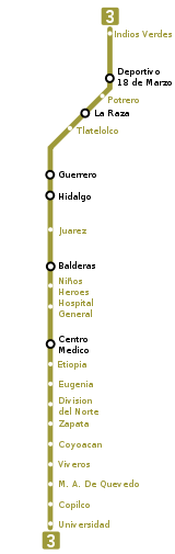
Line 3: Indios Verdes – Universidad
Mexico City Metro Line 3
Mexico City Metro Line 3 is one of the 16 metro lines built in Mexico City, Mexico.Line 3 is the longest line, its color is olive green and it runs from north to south of the city covering almost all of it....
was opened in 1970. It has been expanded five times to comprise 21 stations over a total track length of 23.609 km, of which 21.278 are passenger track, making it the longest of the system. The line has a general north-south direction passing through the western end of downtown Mexico City and its color is olive green.
It is built under Avenida de los Insurgentes
Avenida de los Insurgentes
Avenida de los Insurgentes , sometimes known simply as Insurgentes, is the longest avenue in Mexico City and said to be the longest in the world with a length of on a north-south axis across the city...
, Guerrero, Zarco, Balderas, Cuauhtémoc, Universidad, Copilco and Delfín Madrigal avenues. It commutes with Line 6 at Deportivo 18 de Marzo
Metro Deportivo 18 de Marzo
Metro Deportivo 18 de Marzo is a station on the Mexico City Metro. It is located in Mexico City's Gustavo A. Madero borough.The name of the station refers to the adjacent Deportivo 18 de Marzo sports complex, and its logo represents a player of a pre-Columbian ball game.This station was previously...
, Line 5 at La Raza
Metro La Raza
Metro La Raza is a station on the Mexico City Metro. It is a combinedsubway and surface station, located in the Colonia Vallejo and Colonia Héroes de Nacozari neighbourhoods of the Gustavo A...
, Line B at Guerrero
Metro Guerrero
Metro Guerrero is a metro station on the Mexico City Metro. It is located in the Colonia Guerrero neighborhood of Cuauhtémoc borough of Mexico City, on the intersecion of Zarco street and Eje 1 Norte Mosqueta Avenue...
, Line 2 at Hidalgo
Metro Hidalgo
Metro Hidalgo is a station on Line 2 and Line 3 of the Mexico City Metro system. It is located in the Cuauhtémoc borough of Mexico City, west of the city centre, on Hidalgo Avenue and serves the Colonia Tabacalera, Colonia Guerrero, and Colonia Centro districts....
, Line 1 at Balderas
Metro Balderas
Metro Balderas is an underground station on the Mexico City Metro. It is located in the Cuauhtémoc borough in the center of Mexico City. It is a transfer station along Lines 1 and 3...
and Line 9 at Centro Médico
Metro Centro Médico
Metro Centro Médico is an underground metro station on the Mexico City Metro. It is located in the Cuauhtémoc borough of Mexico City. It is a transfer station for both Lines 3 and 9....
.
Most of the stations (17) run underground with the remaining four, including both terminals, being surface stations. Six stations connect with other metro lines.
 |
|
|---|---|
| Line color | olive green |
| Passenger railway length | 21.278 km |
| Total railway length | 23.609 km |
| Rolling stock | NM-79 trains made in Mexico Mexico The United Mexican States , commonly known as Mexico , is a federal constitutional republic in North America. It is bordered on the north by the United States; on the south and west by the Pacific Ocean; on the southeast by Guatemala, Belize, and the Caribbean Sea; and on the east by the Gulf of... in 1979 |
| Stations | 21 |
| Type of line | Universidad is a superficial terminal. From Copilco to La Raza, underground. From Potrero to Indios Verdes, combines superficial platforms with underground passenger passages. |
| Direction | North-South, though the city center |
| Started operations | November 20, 1970: from Tlatelolco to Hospital General August 25, 1978: from Tlatelolco to La Raza December 1, 1979: from La Raza to Indios Verdes June 7, 1980: from Hospital General to Centro Médico August 25, 1980: from Centro Médico to Zapata August 30, 1983: from Zapata to Universidad |
| Station | Logo | Date opened | Station type | |
|---|---|---|---|---|
| Indios Verdes Metro Indios Verdes Indios Verdes is a station on the Mexico City Metro. Indios Verdes, located in the northern reaches of Mexico City, is the current terminal station for the Metro's Line 3.Indios Verdes literally means "Green Indians"... |
"Green indians" monument | December 1, 1979 | Surface | |
| Deportivo 18 de Marzo Metro Deportivo 18 de Marzo Metro Deportivo 18 de Marzo is a station on the Mexico City Metro. It is located in Mexico City's Gustavo A. Madero borough.The name of the station refers to the adjacent Deportivo 18 de Marzo sports complex, and its logo represents a player of a pre-Columbian ball game.This station was previously... |
Aztec ball game player | |||
| Potrero Metro Potrero Metro Potrero is a metro station on the Mexico City Metro. It is located in the Gustavo A. Madero borough, in the northern part of Mexico City.... |
Horse | |||
| La Raza Metro La Raza Metro La Raza is a station on the Mexico City Metro. It is a combinedsubway and surface station, located in the Colonia Vallejo and Colonia Héroes de Nacozari neighbourhoods of the Gustavo A... |
Pyramid | August 25, 1978 | Underground | |
| Tlatelolco Metro Tlatelolco Metro Tlatelolco is a metro station along Line 3 of the Mexico City Metro. It is located in the Tlatelolco neighbourhood of the Cuauhtémoc borough of Mexico City, to the north of the downtown area... |
The "Banobras" building silhouette | November 20, 1970 | ||
| Guerrero Metro Guerrero Metro Guerrero is a metro station on the Mexico City Metro. It is located in the Colonia Guerrero neighborhood of Cuauhtémoc borough of Mexico City, on the intersecion of Zarco street and Eje 1 Norte Mosqueta Avenue... |
Vicente Guerrero silhouette | |||
| Hidalgo Metro Hidalgo Metro Hidalgo is a station on Line 2 and Line 3 of the Mexico City Metro system. It is located in the Cuauhtémoc borough of Mexico City, west of the city centre, on Hidalgo Avenue and serves the Colonia Tabacalera, Colonia Guerrero, and Colonia Centro districts.... |
Miguel Hidalgo Miguel Hidalgo Miguel Gregorio Antonio Ignacio Hidalgo y Costilla y Gallaga Mandarte Villaseñor , more commonly known as Miguel Hidalgo y Costilla or simply Miguel Hidalgo, was a Mexican priest and a leader of the Mexican War of Independence.In 1810 Hidalgo led a group of peasants in a revolt against the dominant... |
|||
| Juárez Metro Juárez Metro Juárez is a metro station on the Mexico City Metro. It is located in the Cuauhtémoc borough of Mexico City.The station logo depicts the bust of Benito Juárez , who served as president of Mexico for a long period in the 19th century. This station's name, along with Metro Guelatao, refers to... |
Benito Juárez Benito Juárez Benito Juárez born Benito Pablo Juárez García, was a Mexican lawyer and politician of Zapotec origin from Oaxaca who served five terms as president of Mexico: 1858–1861 as interim, 1861–1865, 1865–1867, 1867–1871 and 1871–1872... |
|||
| Balderas Metro Balderas Metro Balderas is an underground station on the Mexico City Metro. It is located in the Cuauhtémoc borough in the center of Mexico City. It is a transfer station along Lines 1 and 3... |
Cannon | |||
| Niños Héroes Metro Niños Héroes Metro Niños Héroes is a metro station along Line 3 of the Mexico City Metro. It is located in the Cuauhtémoc borough of Mexico City.The station logo represents a kepi. Its name refers to the heroic cadets who died defending the military academy in Chapultepec during the Mexican-American War. The... |
a Kepi (military hat) | |||
| Hospital General Metro Hospital General Metro Hospital General is a metro station along Line 3 of the Mexico City Metro. It is located in the Cuauhtémoc borough of Mexico City.The station logo represents the symbol of International Red Cross... |
Cross | |||
| Centro Médico Metro Centro Médico Metro Centro Médico is an underground metro station on the Mexico City Metro. It is located in the Cuauhtémoc borough of Mexico City. It is a transfer station for both Lines 3 and 9.... |
a caduceus | June 7, 1980 | ||
| Etiopía / Plaza de la Transparencia Metro Etiopía Metro Etiopía / Plaza de la Transparencia is a metro station on the Mexico City Metro. It is located in the Benito Juárez borough of Mexico City.... |
Lion | August 25, 1980 | ||
| Eugenia Metro Eugenia Metro Eugenia is a metro station along Line 3 of the Mexico City Metro. It is located in the Colonia Vertiz Narvarte and Colonia del Valle neighbourhoods of the Benito Juárez borough of Mexico City.... |
A Stork | |||
| División del Norte Metro División del Norte Metro División del Norte is a metro station along Line 3 of the Mexico City Metro. It is located in the Benito Juárez borough of Mexico City.... |
Francisco Villa and horse | |||
| Zapata Metro Zapata Metro Zapata is a station on the Mexico City Metro. The station logo depicts Emiliano Zapata, a national hero from the Mexican Revolution of 1910–1921. This station used to be the terminus of Line 3; while the line has since been extended south, it still plays an important role in the... |
Emiliano Zapata Emiliano Zapata Emiliano Zapata Salazar was a leading figure in the Mexican Revolution, which broke out in 1910, and which was initially directed against the president Porfirio Díaz. He formed and commanded an important revolutionary force, the Liberation Army of the South, during the Mexican Revolution... |
|||
| Coyoacán Metro Coyoacán Metro Coyoacán is a metro station along Line 3 of the Mexico City Metro. It is located in the Benito Juárez borough of Mexico City. It is at the intersection of Universidad and Coyoacan avenues. Right outside the station lies the "Centro Coyoacan" shopping mall, Radio Formula and Bancomer... |
Coyote Coyote The coyote , also known as the American jackal or the prairie wolf, is a species of canine found throughout North and Central America, ranging from Panama in the south, north through Mexico, the United States and Canada... |
August 30, 1983 | ||
| Viveros / Derechos Humanos Metro Viveros Metro Viveros / Derechos Humanos is a metro station along Line 3 of the Mexico City Metro. It is located between the Álvaro Obregón and Coyoacán boroughs of Mexico City.... |
the silhouette of a plant | |||
| Miguel Ángel de Quevedo Metro Miguel Ángel de Quevedo Metro Miguel Ángel de Quevedo is a station along Line 3 of the Mexico City Metro. It is located in Mexico City's southern Coyoacán borough, at the junction of Avenida Miguel Ángel de Quevedo and Avenida Universidad.The station logo represents a tree... |
Tree | |||
| Copilco Metro Copilco Metro Copilco is a station along Line 3 on the Mexico City Metro. Located in the Coyoacán borough, in the south of Mexico City, on Avenida Enríquez Ureña... |
Sun | |||
| Universidad Metro Universidad Metro Universidad is astation on the Mexico City Metro. It is located in the southern reaches of Mexico City, in Coyoacán borough. A surface station, it is the current terminus of Line 3... |
UNAM coat of arms | Surface |
Line 4: Santa Anita – Martín Carrera
The first section of line 4 was opened in 1981, and it was expanded once to bring the total extension of this line to ten stations over 10.747 km of track, of which 9.363 km are passenger track. The line has a general north-south direction and is located east of the city center and its color is aquaAquamarine (color)
Aquamarine is a color that is a pale bright tint of spring green toned toward cyan. It is named after the mineral aquamarine, a gemstone mainly found in granite rocks...
. It is also the line with the lowest passenger flow, which is why the STC introduced modified 6-wagon-trains. In the original blueprint, this line was planned to extend to the north all the way to Ecatepec
Ecatepec de Morelos
Ecatepec City, once officially San Cristóbal Ecatepec de Morelos, is a city in the State of México and the seat of Ecatepec de Morelos Municipality; however, both the city and the municipality are often known simply as "Ecatepec". The name "Ecatepec" is derived from Nahuatl, and means "windy hill"....
, Mexico State
Mexico (state)
México , officially: Estado Libre y Soberano de México is one of the 31 states which, with the Federal District, comprise the 32 Federal Entities of the United Mexican States. It is divided in 125 municipalities and its capital city is Toluca de Lerdo....
.
Line 4 is the only one in the system that does not have underground sections. Eight of the ten stations are built on an elevated viaduct and the remaining two are surface stations. Additionally, six stations connect with other metro lines.
It connects with Lines 1 at Candelaria
Metro Candelaria
Metro Candelaria is a station on the Mexico City Metro. It is located in the Venustiano Carranza borough to the east of downtown Mexico City. It lies along Lines 1 and 4.The station logo depicts a swimming duck...
, Line 6 at Martín Carrera
Metro Martín Carrera
Metro Martín Carrera is a station on the Mexico City Metro. It is located at the borders of the Colonia Martín Carrera, Colonia 15 de Agosto, and Colonia Díaz Mirón districts in the Gustavo A. Madero borough, in the north of Mexico City...
, Line 5 at Consulado
Metro Consulado
Metro Consulado is a station on the Mexico City Metro. It is located between Gustavo A. Madero and Venustiano Carranza boroughs, in the north of Mexico City. The station logo depicts the transverse section of a water duct, and refers to a river encased in a duct that runs under nearby Avenida Río...
, Line 8 at Santa Anita
Metro Santa Anita
Metro Santa Anita is a station on the Mexico City Metro. Located in Mexico City's Iztacalco borough, the station is the current terminal of Line 4....
, Line 9 at Jamaica
Metro Jamaica
Metro Jamaica is a station on the Mexico City Metro. It is located in Venustiano Carranza borough, in Mexico City and serves the serves the Sevilla neighbourhood. The station logo depicts an ear of corn. Its name refers to the nearby wholesale market of Jamaica, that sells flowers especially.This...
and Line B at Morelos
Metro Morelos
Morelos is a station on the Mexico City Metro. It is locatedin Venustiano Carranza borough, in the north of Mexico City. The station logo depicts the profile of José María Morelos y Pavón, second instigator of the War of Independence of 1810...
.
 |
|
|---|---|
| Line color | light blue |
| Passenger railway length | 9.363 km |
| Total railway length | 10.747 km |
| Rolling stock | Six-wagon trains built in Spain Spain Spain , officially the Kingdom of Spain languages]] under the European Charter for Regional or Minority Languages. In each of these, Spain's official name is as follows:;;;;;;), is a country and member state of the European Union located in southwestern Europe on the Iberian Peninsula... by C.A.F. Construcciones y Auxiliar de Ferrocarriles Construcciones y Auxiliar de Ferrocarriles is a rail equipment manufacturer based in Beasain in the Basque Country, Spain. Equipment manufactured by CAF includes light rail vehicles, rapid transit trains, railroad cars and locomotives, as well as variable gauge axles that can be fitted on any... |
| Stations | 10 |
| Type of line | 8 elevated viaduct stations and 2 surface stations |
| Direction | North-South, on the east side of the city |
| Started operations | August 29, 1981: from Martín Carrera to Candelaria May 26, 1982: from Candelaria to Santa Anita |
| Station | Logo | Date opened | Station type | |
|---|---|---|---|---|
| Martín Carrera Metro Martín Carrera Metro Martín Carrera is a station on the Mexico City Metro. It is located at the borders of the Colonia Martín Carrera, Colonia 15 de Agosto, and Colonia Díaz Mirón districts in the Gustavo A. Madero borough, in the north of Mexico City... |
Martín Carrera Martín Carrera Martín Carrera Sabat was a Mexican general and interim president of the country for about a month in 1855. He was a moderate Liberal.... |
August 29, 1981 | Surface | |
| Talismán Metro Talismán Talismán is a station along Line 4 of the Mexico City Metro, located in Gustavo A. Madero borough.The station logo depicts a stylised image of a mammoth, with raised trunk and tusks. During the construction of this station, the fossilised remains of a mammoth were dug up by an excavation gang.... |
Mamooth | Elevated | ||
| Bondojito Metro Bondojito Metro Bondojito is a metro station along Line 4 of the Mexico City Metro. It is located in the Gustavo A. Madero borough of Mexico City.The station logo depicts a cactus, and its name refers to the Otomí word of Bondo, that means, in fact, cactus... |
Nopal | |||
| Consulado Metro Consulado Metro Consulado is a station on the Mexico City Metro. It is located between Gustavo A. Madero and Venustiano Carranza boroughs, in the north of Mexico City. The station logo depicts the transverse section of a water duct, and refers to a river encased in a duct that runs under nearby Avenida Río... |
A trasversal section of a water duct | |||
| Canal del Norte Metro Canal del Norte Metro Canal del Norte is a station on the Mexico City Metro. It is located in the Venustiano Carranza borough, in the north of Mexico City. The station logo depicts the transverse section of Canal del Norte a water way that connected Mexico City with La Villa in the colonial era.The station is... |
A tranversal section af a water way | |||
| Morelos Metro Morelos Morelos is a station on the Mexico City Metro. It is locatedin Venustiano Carranza borough, in the north of Mexico City. The station logo depicts the profile of José María Morelos y Pavón, second instigator of the War of Independence of 1810... |
José María Morelos José María Morelos José María Teclo Morelos y Pavón was a Mexican Roman Catholic priest and revolutionary rebel leader who led the Mexican War of Independence movement, assuming its leadership after the execution of Miguel Hidalgo y Costilla in 1811... |
|||
| Candelaria Metro Candelaria Metro Candelaria is a station on the Mexico City Metro. It is located in the Venustiano Carranza borough to the east of downtown Mexico City. It lies along Lines 1 and 4.The station logo depicts a swimming duck... |
Duck | Surface | ||
| Fray Servando Metro Fray Servando Metro Fray Servando is a metro station along Line 4 of the Mexico City Metro. It is located in the Venustiano Carranza borough of Mexico City.... |
Servando Teresa de Mier Servando Teresa de Mier Fray Servando Teresa de Mier was a Roman Catholic priest and a preacher and politician in New Spain.... |
May 26, 1982 | Elevated | |
| Jamaica Metro Jamaica Metro Jamaica is a station on the Mexico City Metro. It is located in Venustiano Carranza borough, in Mexico City and serves the serves the Sevilla neighbourhood. The station logo depicts an ear of corn. Its name refers to the nearby wholesale market of Jamaica, that sells flowers especially.This... |
An ear of corn | |||
| Santa Anita Metro Santa Anita Metro Santa Anita is a station on the Mexico City Metro. Located in Mexico City's Iztacalco borough, the station is the current terminal of Line 4.... |
A man sailing in a canoe |
Line 5: Politécnico – Pantitlán

Mexico City Metro Line 5
Mexico City Metro Line 5 is one of the 11 metro lines built in Mexico City, Mexico.It has as its color the color yellow and runs from the north to the east...
was opened in 1981, and it has been expanded twice to bring the total extension of this line to 13 stations over 15.675 km of track, of which 14.435 km are passenger track. The line has a general north-west to south-east direction relative to the city center and its color is yellow
Yellow
Yellow is the color evoked by light that stimulates both the L and M cone cells of the retina about equally, with no significant stimulation of the S cone cells. Light with a wavelength of 570–590 nm is yellow, as is light with a suitable mixture of red and green...
. This line previously had the NM73 trains but due to the introduction of the NM02 trains in Line 2 now it is served by NC82 Canadian trains made by Bombardier. Line 5 runs to Mexico City International Airport
Mexico City International Airport
Benito Juárez International Airport , in Venustiano Carranza, one of the sixteen boroughs into which Mexico's Federal District is divided, is a commercial airport that serves Mexico City, the capital of Mexico...
(Terminal Aérea station).
Line 5 has four underground and nine surface stations. Five stations connect with other metro lines.
 |
|
|---|---|
| Line color | yellow |
| Rolling stock | NC-82 trains made in Canada Canada Canada is a North American country consisting of ten provinces and three territories. Located in the northern part of the continent, it extends from the Atlantic Ocean in the east to the Pacific Ocean in the west, and northward into the Arctic Ocean... in 1982 |
| Passenger railway length | 14.435 km |
| Total railway length | 15.675 km |
| Stations | 13 |
| Type of line | From Politécnico to La Raza, superficial with underground access. Misterios and Valle Gómez, underground From Consulado to Oceanía, superficial with underground access Terminal Aérea and Hangares, underground and Pantitlán is superficial. |
| Direction | North-East |
| Started operations | December 19, 1981: from Pantitlán to Consulado July 1, 1982: from Consulado to La Raza August 30, 1982: from La Raza to Politécnico |
| Station | Logo | Date opened | Station type | |
|---|---|---|---|---|
| Politécnico Metro Politécnico Metro Politécnico is a station on the Mexico City Metro. It is located in the north of Mexico City, in the Gustavo A. Madero borough. It is the northern terminus for Line 5.... |
IPN coat of arms | August 30, 1982 | Surface | |
| Instituto del Petróleo Metro Instituto del Petróleo Metro Instituto del Petróleo is a station along Line 5 and Line 6 of the metro of Mexico City serving the Colonia Valle del Tepeyac, Colonia San Bartolo Atepehuapan, and Colonia Nueva Industrial districts of the Gustavo A... |
A petroleum tower | |||
| Autobuses del Norte Metro Autobuses del Norte Autobuses del Norte is a station on Line 5 of the Mexico City Metro. It is located in the north of Mexico City, in Gustavo A. Madero borough.The station's logo is a front view of an intercity bus, and the station's name means "northern buses"... |
Foreign Bus | |||
| La Raza Metro La Raza Metro La Raza is a station on the Mexico City Metro. It is a combinedsubway and surface station, located in the Colonia Vallejo and Colonia Héroes de Nacozari neighbourhoods of the Gustavo A... |
Pyramid | July 1, 1982 | ||
| Misterios Metro Misterios Metro Misterios is a station on Line 5 of the Mexico City Metro. The station was opened on 1 July 1982. The station serves the Colonia Vallejo and Colonia Peralvillo neighborhoods of the Azcapotzalco borough in the northern portion of Mexico City.... |
a "Misterios" Monument | Underground | ||
| Valle Gómez Metro Valle Gómez Metro Valle Gómez is a station along the Line 5 of the metro of Mexico City.The logo represents an agave plant, symbol of a pasture land that was nearby named La Vaquita, where lots of agave plants would grow. The station was opened on 1 July 1982.... |
Agave plant | |||
| Consulado Metro Consulado Metro Consulado is a station on the Mexico City Metro. It is located between Gustavo A. Madero and Venustiano Carranza boroughs, in the north of Mexico City. The station logo depicts the transverse section of a water duct, and refers to a river encased in a duct that runs under nearby Avenida Río... |
Transversal cut uf a duct of water | December 19, 1981 | Surface | |
| Eduardo Molina Metro Eduardo Molina Metro Eduardo Molina is a station on Line 5 of the Mexico City Metro. It is a surface station that lies within the median of Avenida Río Consulado. It serves the Colonia Malinche and Colonia 20 de Noviembre neighborhoods of Mexico City... |
Hands holding water | |||
| Aragón Metro Aragón Metro Aragón is a station on the Mexico City Metro. It is located in the northeast quarter of Mexico City, in the Colonia Casas Alemán and Colonia Simón Bolívar districts of the Venustiano Carranza borough. It lies along Line 5... |
Squirrel | |||
| Oceanía Metro Oceanía Oceanía is a station on the Mexico City Metro. It is located in Mexico City's Venustiano Carranza borough, to the northeast of the city centre. It's a transfer station for Metro Lines 5 and B. It stands on the corner of Avenida Oceanía and Avenida Río Consulado, which is part of the Circuito... |
Kangaroo | |||
| Terminal Aérea Metro Terminal Aérea Metro Terminal Aérea is a station along Line 5 of the Mexico City Metro. It is located in the Venustiano Carranza borough of Mexico City. It serves the Colonia Peñón de los Baños and Colonia Moctezuma 2ª sección neighbourhoods.... |
Aerial control tower and a plane | Underground | ||
| Hangares Metro Hangares Metro Hangares is a surface metro station along Line 5 of the Mexico City Metro. It is located near the intersection of Fuerza Aérea Mexicana and Correos y Telégrafos in the Colonia Federal neighborhood of the Venustiano Carranza, D.F. borough of Mexico City.Its logo represents a hangar, several... |
Biplane | |||
| Pantitlán Metro Pantitlán Metro Pantitlán is a station on the Mexico City Metro. It is located in the Iztacalco borough, to the east of downtown Mexico City city centre... |
Two Flags | Surface |
Line 6: El Rosario – Martín Carrera
Line 6 had its first section inaugurated in 1983. It has been expanded once to bring the total extension of the line to 11 stations over 13.947 km of track, of which 11.434 are passenger track. This line has a west-east direction running north of the city center and its color is scarletScarlet (color)
Scarlet is a bright red color with a hue that is somewhat toward the orange. It is redder than vermilion. It is a pure chroma on the color wheel one-fourth of the way between red and orange. Scarlet is sometimes used as the color of flame...
red
Red
Red is any of a number of similar colors evoked by light consisting predominantly of the longest wavelengths of light discernible by the human eye, in the wavelength range of roughly 630–740 nm. Longer wavelengths than this are called infrared , and cannot be seen by the naked eye...
.
The line has only one surface station, the El Rosario terminal, while the rest of the line runs under ground. Four stations connect with other metro lines. Line 6, like line 4, is also served by customized six-car trains.
 |
|
|---|---|
| Line color | red |
| Passenger railway length | 11.434 km |
| Total railway length | 13.947 km |
| Rolling stock | due to the low volume of persons in the line, the STC introduced six-wagon trains |
| Stations | 11 |
| Type of line | El Rosario is a superficial terminal. From Tezozomoc to Martín Carrera, underground. |
| Direction | West-East, in the city north |
| Started operations | December 21, 1983: from El Rosario to Instituto del Petróleo July 8, 1986: from Instituto del Petróleo to Martín Carrera |
| Station | Logo | Date opened | Station type | |
|---|---|---|---|---|
| El Rosario Metro El Rosario Metro El Rosario is a surface station on the Mexico City Metro. It is located in Azcapotzalco borough, in the northern reaches of Mexico City. It serves as the terminal for both Lines 6 and 7.The station logo depicts a set of rosary beads.... |
A Rosary | December 21, 1983 | Surface | |
| Tezozomoc Metro Tezozómoc Metro Tezozómoc is a metro station on Mexico's Line 6. Its logo is a profile of King Tezozómoc, who ruled the Aztec for 80 years. The station can be accessed through Ahuehuetes and Avenida Sauces Colonia Pasteros, in the Azcapotzalco borough... |
Tezozomoc | Underground | ||
| Azcapotzalco Metro Azcapotzalco Metro Azcapotzalco is a metro station in northern Mexico City. It travels through Line 6. Its Logo is that of an ant... |
Ant | |||
| Ferrería Metro Ferrería Metro Ferrería is a station along Line 6 of the Mexico City Metro. It is located in the Azcapotzalco borough, in the north of Mexico City.The station logo depicts the head of a cow... |
A Cow Head | |||
| Norte 45 Metro Norte 45 Norte 45 is a station on Line 6 of the Mexico City Metro. It is located in the Colonia Pueblo Salinas neighborhood.The logo for this station is a compass rose and the station takes its name from a nearby street that runs from northeast to southwest... |
A windrose | |||
| Vallejo Metro Vallejo Metro Vallejo is a station along Line 6 of the Mexico City Metro. It is located in the Colonia Vallejo neighborhood of the Azcapotzalco borough of northwestern Mexico City.... |
A factory | |||
| Instituto del Petróleo Metro Instituto del Petróleo Metro Instituto del Petróleo is a station along Line 5 and Line 6 of the metro of Mexico City serving the Colonia Valle del Tepeyac, Colonia San Bartolo Atepehuapan, and Colonia Nueva Industrial districts of the Gustavo A... |
A petroleum tower | |||
| Lindavista Metro Lindavista Lindavista is a metro station along Line 6 of the Mexico City Metro.Its logo is the silhouette of the nearby Temple of San Cayetano Apóstol.The station serves the Colonia Lindavista neighborhood from which it draws its name. It opened on 8 July 1986.... |
San Cayetano church | July 8, 1986 | ||
| Deportivo 18 de Marzo Metro Deportivo 18 de Marzo Metro Deportivo 18 de Marzo is a station on the Mexico City Metro. It is located in Mexico City's Gustavo A. Madero borough.The name of the station refers to the adjacent Deportivo 18 de Marzo sports complex, and its logo represents a player of a pre-Columbian ball game.This station was previously... |
Aztec ball game player | |||
| La Villa-Basílica Metro La Villa-Basílica La Villa-Basílica is station along Line 6 of the Mexico City Metro.Its logo is the façade of the nearby Basilica of Our Lady of Guadalupe.The station serves the Colonia Aragón and Colonia La Villa neighborhoods. It opened on 8 July 1986.... |
Basílica de Guadalupe and Guadalupe virgin | |||
| Martín Carrera Metro Martín Carrera Metro Martín Carrera is a station on the Mexico City Metro. It is located at the borders of the Colonia Martín Carrera, Colonia 15 de Agosto, and Colonia Díaz Mirón districts in the Gustavo A. Madero borough, in the north of Mexico City... |
Martín Carrera |
Line 7: El Rosario – Barranca del Muerto
The first section of line 7 was opened to the public in 1984. It has been expanded three times to bring the total length of the line to 14 stations over 18.784 km of track, of which 17.011 km are passenger track. Line 7 has a north-south direction running west of the city center and its color is orangeOrange (colour)
The colour orange occurs between red and yellow in the visible spectrum at a wavelength of about 585–620 nm, and has a hue of 30° in HSV colour space. It is numerically halfway between red and yellow in a gamma-compressed RGB colour space, the expression of which is the RGB colour wheel. The...
.
The line has its only surface station in the El Rosario terminal. The rest of the line runs under ground, with some sections being located more than 20 m below street-level, making it the deepest line in the system at a maximum of 36 meters. Three stations connect with other metro lines.
This line used MP68 trains and a small number of NM73, after the rehabilitation of some MP68. They kept circulating on this line although there is a slightly bigger number of NM79 and NM83 in this line. Today there are only retroadapted NM73 and NM83 models and some trains from the first model due to the introduction of the NM02 in the Line 2. Currently the MP68 Trains from Line 9 are being reintroduced.
 |
|
|---|---|
| Line color | orange |
| Passenger railway length | 17.011 km |
| Total railway length | 18.784 km |
| Stations | 14 |
| Type of line | El Rosario is a surface terminal. From Aquiles Serdán to Barranca del Muerto, stations are underground. |
| Direction | North-South, at the city west |
| Started operations | December 20, 1984: from Tacuba to Auditorio August 22, 1985: from Auditorio to Tacubaya December 19, 1985: from Tacubaya to Barranca December 29, 1988: from Tacuba to El Rosario |
| Station | Logo | Date opened | Station type | |
|---|---|---|---|---|
| El Rosario Metro El Rosario Metro El Rosario is a surface station on the Mexico City Metro. It is located in Azcapotzalco borough, in the northern reaches of Mexico City. It serves as the terminal for both Lines 6 and 7.The station logo depicts a set of rosary beads.... |
A Rosary | December 29, 1988 | Surface | |
| Aquiles Serdán Metro Aquiles Serdán Metro Aquiles Serdán is a station along Line 7 of the Mexico City Metro. It is located in the Colonia La Preciosa neighborhood of the Azcapotzalco borough of northwestern Mexico City.... |
Aquiles Serdán | Underground | ||
| Camarones Metro Camarones Camarones is a station along Line 7 of the Mexico City Metro. It is located in Colonia Barrio Santa Cruz Acayucan district in the Azcapotzalco borough, north of Mexico City, Mexico. The station was opened with the others along the northern portion of Line 7 on 29 November 1988.Its name and logo... |
A shrimp | |||
| Refinería | A PEMEX refinery container | |||
| Tacuba Metro Tacuba Metro Tacuba is a station of the Mexico City Metro. It is located in the Tacuba district of the Miguel Hidalgo borough, to the west of downtown Mexico City. It lies along Lines 2 and 7.... |
Flowers | December 20, 1984 | ||
| San Joaquín Metro San Joaquín Metro San Joaquín is a station along Line 7 of the metro of Mexico City.Its logo represents the silhouette of a bridge of the radial Viaducto Río San Joaquín.It was opened on 20 December 1984.... |
Bridge | |||
| Polanco Metro Polanco Metro Polanco is a station along Line 7 of the Mexico City Metro. The station opened on 20 December 1984. It serves the Polanco neighborhood. The logo for the station features a silhouette of a building typical of the architecture of Polanco.... |
A Clock Tower | |||
| Auditorio Metro Auditorio Metro Auditorio is a Mexico City Metro station located on line 7. It is one of the main metro gateways to the chic and business-related neighbourhood, Polanco. The entrances to the station are on Paseo de la Reforma, one of the main thoroughfares in Mexico City.Its symbol depicts the façade of... |
Auditorio building | |||
| Constituyentes Metro Constituyentes Constituyentes is a station on Line 7 of the Mexico City metro on the western outskirts of the city center. It serves Chapultepec Park and numerous attractions therein, as well as the Luis Barragán House and Studio. The station opened on 23 August 1985.... |
A book, ink and a Feather | August 22, 1985 | ||
| Tacubaya Metro Tacubaya Metro Tacubaya is a station on Lines 1, 7 and 9 of the Mexico City Metro system. It is located in the Miguel Hidalgo borough of Mexico City, west of the city centre.... |
A Water bowl | |||
| San Pedro de los Pinos Metro San Pedro de los Pinos Metro San Pedro de los Pinos is a station on Line 7 of the Mexico City Metro system. It is located in the Miguel Hidalgo borough of Mexico City, west of the city centre. The station opened on 19 December 1985.... |
Two Pines | December 19, 1985 | ||
| San Antonio Metro San Antonio Metro San Antonio is a metro station on Line 7 of the Mexico City Metro. The station opened on 19 December 1985.- External links :... |
San Antonio and a kid | |||
| Mixcoac Metro Mixcoac Metro Mixcoac is a station on Line 7 of the Mexico City Metro. It runs deep under Avenida Revolución, a main thoroughfare in Mexico City. It serves the Colonia Mixcoac neighborhood of the city.... |
A snake | |||
| Barranca del Muerto Metro Barranca del Muerto Metro Barranca del Muerto is a station on the Mexico City Metro,Mexico. It is located in the Álvaro Obregón borough. Its logo represents two eagles, some say buzzards.... |
Two Eagles |
Line 8: Garibaldi / Lagunilla – Constitución de 1917
Line 8 was the next to last route of the network to be opened, on July 20, 1994 by then President Carlos Salinas de Gortari and then regent of the city, Manuel Aguilera Gómez. Construction plans for the line date back to much earlier, but they were put on hold due to significant redevelopment. It has 19 stations over a total track length of 20.078 km, of which 16.679 are passenger track. Line 8 runs in a general south-east direction, beginning near the city center, and its color is bright green.The line has 14 underground stations and five surface stations, including the southern terminal Constitución de 1917. Five stations connect line 8 with other metro lines.
According to the Sistema de Transporte Colectivo, the volume of people moved in this line was 117,386,342 persons in 2006.
 |
|
|---|---|
| Line color | green |
| Passenger railway length | 16.679 km |
| Total railway length: | 20.078 km |
| Rolling stock | MP82 trains made in France France The French Republic , The French Republic , The French Republic , (commonly known as France , is a unitary semi-presidential republic in Western Europe with several overseas territories and islands located on other continents and in the Indian, Pacific, and Atlantic oceans. Metropolitan France... between 1982 and 1984 |
| Stations | 19 |
| Direction | Center-Southeast |
| Started operations | July 20, 1994 |
| Station | Logo | Date opened | Station type | |
|---|---|---|---|---|
| Garibaldi / Lagunilla Metro Garibaldi Metro Garibaldi, also known as Garibaldi/Lagunilla, is a station on the Mexico City Metro. It is a transfer station, serving both Lines 8 and B. It is the northern terminus of Line 8.... |
A guitar and a sarape | July 20, 1994 | Underground | |
| Bellas Artes Metro Bellas Artes Metro Bellas Artes is a station along Line 2 and Line 8 of the Mexico City Metro system. It is located in the Colonia Centro district of the Cuauhtémoc borough of Mexico City, on the junction of Avenida Juárez and Eje Central Lázaro Cárdenas, on the eastern end of the Alameda Central, west of the... |
Bellas Artes builging | |||
| San Juan de Letrán Metro San Juan de Letrán border=1 align=right cellpadding=0 cellspacing=0 width=200 style="margin: 1.5em 0 1em 1em; background: #FF9933; border: 0px #aaaaaa solid; font-size: 95%;" | align=center colspan="2" |... |
Latinoamerican Tower | |||
| Salto del Agua Metro Salto del Agua Metro Salto del Agua is a metro station on the Mexico City Metro. It is located in the Cuauhtémoc borough in the centre of Mexico City.... |
Fountain | |||
| Doctores Metro Doctores Metro Doctores is a station on Line 8 of the Mexico City Metro.Its logo is the silhouette of two doctors. The station is named after Colonia Doctores, the neighborhood in which it is located, whose streets commemorate famous doctors of the era of La Reforma.On 7 March 2007 a 30 year old woman... |
Two doctors | |||
| Obrera Metro Obrera Metro Obrera is a station along Line 8 of the metro of Mexico City.The station is situated on Eje Central Lázaro Cárdenas.The station's logo is a construction worker's helmet framed with two gears. The name obrera comes from the Colonia Obrera neighbourhood where the station is located.- References :... |
A helmet and two gears | |||
| Chabacano Metro Chabacano Metro Chabacano is a station on Lines 2, 8 and 9 of the Mexico City Metro system. It is located in the Cuauhtémoc borough of Mexico City, south of the city centre, on Calzada de Tlalpan.Chabacano means apricot in Mexican Spanish... |
Apricot | |||
| La Viga Metro La Viga Metro La Viga is a station along Line 8 of the metro of Mexico City.The station's logo is a pair of fishes since the neighborhood it serves is home to Mercado de La Viga – one of the larger seafood markets in Mexico City.... |
Two Fish | |||
| Santa Anita Metro Santa Anita Metro Santa Anita is a station on the Mexico City Metro. Located in Mexico City's Iztacalco borough, the station is the current terminal of Line 4.... |
A man sailing in a canoe | |||
| Coyuya Metro Coyuya Metro Coyuya is a station on the Mexico City Metro.Metro Coyuya is on Line 8, between Metro Santa Anita and Metro Iztacalco. It is located in the Iztacalco borough, in the eastern portion of the Mexican Federal District, and serves the Colonia Tlazintla district and neighbourhoods surrounding... |
A foot | Surface | ||
| Iztacalco Metro Iztacalco Metro Iztacalco is a station along Line 8 of the Mexico City Metro.Metro Iztacalco is in the Iztacalco borough of the Mexican Federal District. Its logo represents the monastery of San Matías, the first church on Calzada de la Viga. The Nahuatl toponym Iztacalco means "in the house of salt"... |
San Matias Church | |||
| Apatlaco Metro Apatlaco Metro Apatlaco is a station along Line 8 of the metro of Mexico City.The station's logo is a house with hot water and steam inside of it. Apatlaco is a Nahuatl word that means "place of medicinal baths". The station was opened on 20 July 1994.... |
An aztec temple with boiling water | |||
| Aculco Metro Aculco Metro Aculco is a station along Line 8 of the metro of Mexico City. It is located under the bridge where the Trabajadoras Sociales passes over the Eje 3 Ote in the Colonia Pueblo Aculco neighborhood if the Iztapalapa borough of Mexico City.... |
A Wave | |||
| Escuadrón 201 Metro Escuadrón 201 Escuadrón 201 is a metro station in Mexico City, Mexico. It is located in the city's eastern Iztapalapa delegación, close to the intersection of Eje 3 Oriente and Eje 8 Sur .... |
Escuadron 201 logo | Underground | ||
| Atlalilco | A water well | |||
| Iztapalapa Metro Iztapalapa Metro Iztapalapa is a station along Line 8 of the metro of Mexico City.It is located on the Calzada Ermita Iztapalapa in the Colonia El Santuario neighborhood of Iztapalapa borough on the southeast side of the city.... |
A Sun | |||
| Cerro de la Estrella Metro Cerro de la Estrella Metro Cerro de la Estrella is an underground station along Line 8 of the metro of Mexico City.The station is located along the Calzada Ermita-Iztapalapa and serves the Colonia Hidalgo y Mina neighborhood within the Iztapalapa borough on the east side of the city.The station is named for the Cerro... |
A hil with three crosses and a star | |||
| UAM-I Metro UAM-I Metro UAM-I is a station along Line 8 of the Mexico City Metro.The station's logo is the logo of the Universidad Autónoma Metropolitana campus Iztapalapa, which is close to the station. The station was opened on 20 July 1994. Until 1995 this station was known as La Purísima, the name of the street... |
UAM coat of arms | |||
| Constitución de 1917 Metro Constitución de 1917 Constitución de 1917 is a terminal station at the southeastern end of line 8 of the Mexico City Metro in Mexico City, Mexico.The logo of the station depicts a quill above a document dated 1917 and is intended to represent the Constitution of Mexico, which was adopted 5 February 1917. The station... |
Pergamin with a feather writing 1917 | Surface |
Line 9: Tacubaya – Pantitlán
The first section of line 9 was opened to the public in 1987. It has been expanded once to a length of 12 stations over 15.375 km of track, of which 13.033 are passenger track. The line was opened to relieve passenger traffic from line 1, to which it runs parallel south of the city center. The color of the line is dark brownBrown
Brown is a color term, denoting a range of composite colors produced by a mixture of orange, red, rose, or yellow with black or gray. The term is from Old English brún, in origin for any dusky or dark shade of color....
.
Line 9 has eight underground stations with the remaining being elevated stations similar to those in line 4, including the terminal Pantitlán. It is the only line in the system in which no section of the track runs at street-level. Additionally, five stations connect with other metro lines. The trains of this line are made up from MP68 trains rehabilitated with fans and intelligent control systems and some NM79 rolling stock.
 |
|
|---|---|
| Line color | brown |
| Passenger railway length | 13.033 km |
| Total railway length | 15.375 km |
| Station | 12 |
| Direction | West-East, through the city center |
| Started operations | August 26, 1987: from Pantitlán to Centro Médico August 29, 1988: from Centro Médico to Tacubaya |
| Station | Logo | Date opened | Station type | |
|---|---|---|---|---|
| Tacubaya Metro Tacubaya Metro Tacubaya is a station on Lines 1, 7 and 9 of the Mexico City Metro system. It is located in the Miguel Hidalgo borough of Mexico City, west of the city centre.... |
A Water bowl | August 29, 1988 | Underground | |
| Patriotismo Metro Patriotismo Metro Patriotismo is a metro station on the Mexico City Metro. It is located in both the Cuauhtémoc and Miguel Hidalgo boroughs of Mexico City. It is part of the metro line 9.... |
The Mexican flag | |||
| Chilpancingo Metro Chilpancingo Metro Chilpancingo is an underground metro station along Line 9 of the Mexico City Metro. It is located in the Cuauhtémoc borough of Mexico City. It is very close to Metrobús station of the same name.... |
A wasp | |||
| Centro Médico Metro Centro Médico Metro Centro Médico is an underground metro station on the Mexico City Metro. It is located in the Cuauhtémoc borough of Mexico City. It is a transfer station for both Lines 3 and 9.... |
A caduceus | August 26, 1987 | ||
| Lázaro Cárdenas Metro Lázaro Cárdenas Metro Lázaro Cárdenas is on Line 9 of the Mexico City Metro System between Metro Centro Médico and Metro Chabacano at the intersection of Eje Central and Eje 3 Sur. It links to the Eje Central Trolebus line.... |
Lázaro Cárdenas | |||
| Chabacano Metro Chabacano Metro Chabacano is a station on Lines 2, 8 and 9 of the Mexico City Metro system. It is located in the Cuauhtémoc borough of Mexico City, south of the city centre, on Calzada de Tlalpan.Chabacano means apricot in Mexican Spanish... |
Apricot | |||
| Jamaica Metro Jamaica Metro Jamaica is a station on the Mexico City Metro. It is located in Venustiano Carranza borough, in Mexico City and serves the serves the Sevilla neighbourhood. The station logo depicts an ear of corn. Its name refers to the nearby wholesale market of Jamaica, that sells flowers especially.This... |
An ear of corn | |||
| Mixiuhca Metro Mixiuhca Metro Mixiuhca is a metro station along Line 9 of the Mexico City Metro serving the Colonia Jardín Balbuena and Colonia Magdalena Mixiuhca districts in the Venustiano Carranza borough of Mexico City, Mexico. The station's icon is a silhouette of a woman holding a newborn baby. In the Nahuatl... |
A woman with a baby | |||
| Velódromo Metro Velódromo Metro Velódromo is a metro station located on Line 9 of the Mexico City Metro. It is named after the nearby Agustín Melgar Olympic Velodrome, or bicycle-racing venue, built for the1968 Summer Olympics that were held in Mexico City.... |
A bicyclist | Elevated | ||
| Ciudad Deportiva Metro Ciudad Deportiva Metro Ciudad Deportiva is a metro station along Line 9 of the Mexico City Metro. It is named for the nearby the Magdalena Mixhuca Sports City.... |
Another version of the Aztec ball game player | |||
| Puebla Metro Puebla Metro Puebla is a station on the Mexico City Metro. It is located in the Puebla district of the Iztacalco delegation of Mexico City; both the area it is located in and the station are named for the nearby city of Puebla... |
Two angles carrying Puebla coat of arms | |||
| Pantitlán Metro Pantitlán Metro Pantitlán is a station on the Mexico City Metro. It is located in the Iztacalco borough, to the east of downtown Mexico City city centre... |
Two flags |
Line A (10): Pantitlán – La Paz
Line A was the second metro line that extended into the suburbs of Mexico City outside the Mexican Federal District. Opened in its entirety in 1991, it comprises ten stations over 17.192 km of track, of which 14.893 km are passenger track. Line A runs in a general south-east direction, east of the city center, and its color is purplePurple
Purple is a range of hues of color occurring between red and blue, and is classified as a secondary color as the colors are required to create the shade....
.
Line A has only one underground station, the terminal Pantitlán, while the rest of the line runs at street-level. Only one station makes connections with other metro lines.
Line A is unique within the system in the sense that it uses traditional rail traction as opposed to pneumatic traction as the rest of the lines (excluding future line 12). As a reference, it is often called metro férreo. The line is served by FM-86 trains, built in Mexico in 1986 and FM-95A trains, also built in Mexico between 1998 and 1999, which draw electricity through a pantograph
Pantograph (rail)
A pantograph for rail lines is a hinged electric-rod device that collects electric current from overhead lines for electric trains or trams. The pantograph typically connects to a one-wire line, with the track acting as the ground wire...
.
 |
|
|---|---|
| Line color | purple |
| Passenger railway length | 14.893 km |
| Total railway length | 23.722 km |
| Rolling stock | FM86 trains, made in Mexico in 1986; FM95A, made in Mexico in 1998 and 1999; FE07, made in Spain in 2009 |
| Stations | 10 |
| Direction | East-Far East |
| Started operations | August 12, 1991: From Pantitlán to La Paz |
| Station | Logo | Date opened | Station type | |
|---|---|---|---|---|
| Pantitlán Metro Pantitlán Metro Pantitlán is a station on the Mexico City Metro. It is located in the Iztacalco borough, to the east of downtown Mexico City city centre... |
Two flags | August 12, 1991 | Underground | |
| Agrícola Oriental Metro Agrícola Oriental Metro Agrícola Oriental is a metro station on Line A of the Mexico City Metro system.It opened on 12 August 1991 as did the other stations along the rest of Line A.The logo for the station represents two spikes of wheat.... |
Two ears of wheat | Surface | ||
| Canal de San Juan Metro Canal de San Juan Canal de San Juan is a station along Line A of the Mexico City Metro.The logo for the station depicts the bow of an Aztec canoe travelling through a canal. The station was opened on 12 August 1991.- References :... |
An Aztec canoe in a canal | |||
| Tepalcates Metro Tepalcates Tepalcates is a station on the Mexico City Metro. It is located in the Iztapalapa borough, to the east of downtown Mexico City. It is on Line A. It is also the eastern terminus of Metrobús line 2. The station was opened on 12 August 1991.... |
A mud plate | |||
| Guelatao Metro Guelatao Guelatao is a station along Line A of the Mexico City Metro. It is located in the Colonia Voceadores and Colonia Ejercito de Oriente neighborhoods of the Iztapalapa borough of northeastern Mexico City.... |
The head of Benito Juárez | |||
| Peñón Viejo Metro Peñón Viejo Peñon Viejo is a station along Line A of the Mexico City Metro. It is located in the Colonia Santa Martha Acatitla Norte and Colonia Santa Martha Acatitla Sur neighborhoods of the Iztapalapa borough of Mexico City.... |
The Aztec representation of promontory | |||
| Acatitla Metro Acatitla Acatitla is a station along Line A of the Mexico City Metro. It is an aboveground station. The station has connections to bus routes 162B, 163, 163A, 163B, 164, and 166. Service at this station began 12 August 1991.-External links:*... |
A sugarcane | |||
| Santa Marta Metro Santa Marta Santa Marta is a station along Line A of the Mexico City Metro. It is located in the Colonia Ermita Zaragoza neighborhood of the Iztapalapa borough in Mexico City.... |
Santa Marta with a jar | |||
| Los Reyes Metro Los Reyes Los Reyes is a surface station along Line A of the Mexico City Metro. It is located in the Colonia Los Reyes Acaquilpa neighborhood in La Paz municipio in the State of Mexico adjacent to Mexico City.... |
Three crowns | |||
| La Paz Metro La Paz (Mexico City Metro) La Paz is a Mexico City Metro station that serves Line A. It is currently the terminal station. It opened, along with the other stations along Line A, on 12 August 1991... |
A dove |
Line B (11): Buenavista – Ciudad Azteca
Line B became the third line to extend into the suburbs of Mexico City. The first section of the line was opened in 1999 and was expanded once to comprise a total of 21 stations over 23.722 km of track, of which 20.278 are passenger track. Line B starts north of the city center and runs in a general north-east direction relative to it. Its color is green on silverSilver (color)
Silver is the metallic shade resembling gray, closest to that of polished silver.The visual sensation usually associated with the metal silver is its metallic shine. This cannot be reproduced by a simple solid color, because the shiny effect is due to the material's brightness varying with the...
.
Six stations of line B run under ground, four are elevated and 11 run at street-level. Five stations connect with other metro lines.
All the trains are MP68 modified and equipped with GPS and intelligent control system, the trains in this line were the leftovers from Line 1 that were rehabilitated by Bombardier-Concarril.
| Line color | green over silver. |
| Passenger railway length | 20.278 km |
| Total railway length | 23.722 km |
| Stations | 21 |
| Direction | City Center-Far Northeast |
| Started operations | December 15, 1999: from Buenavista to Villa de Aragón November 30, 2000: from Villa de Aragón to Ciudad Azteca |
| Station | Logo | Date opened | Station type | |
|---|---|---|---|---|
| Ciudad Azteca Metro Ciudad Azteca Ciudad Azteca is a surface terminal station on Line B of the Mexico City Metro system. It is located in the median of Avenida Carlos Hank González... |
Aztec symbol of Tenochtitlan | November 30, 2000 | Surface | |
| Plaza Aragón Metro Plaza Aragón Plaza Aragón is a surface station on Line B of the Mexico City Metro system. The station was opened on 30 November 2000. It is located in the median of Avenida Carlos Hank González in the Colonia Rinconada de Aragón neighborhood in the State of Mexico adjacent to Mexico City.The station logo... |
A stand | |||
| Olímpica Metro Olímpica Olímpica is a station on Line B of the Mexico City Metro system. The station is located at Avenida Central and Avenida Valle de Santiago in the Colonia Jardines de Aragón neighborhood and Avenida Grecia in the Colonia La Olimpica II neighborhood in the State of Mexico adjacent to Mexico City.The... |
The Olympic rings | |||
| Ecatepec Metro Ecatepec Ecatepec is a station on Line B of the Mexico City Metro system. It is in the Ecatepec de Morelos city in the State of Mexico adjacent to Mexico City. The station opened on November 30, 2000, under its original name, Metro Tecnológico. The station's icon was the emblem of the Tecnológico de... |
The Ecatepec symbol | |||
| Múzquiz Metro Muzquiz Múzquiz is a station on Line B of the Mexico City Metro system. The station was opened on 30 November 2000. It is named after Melchor Múzquiz who served as President of Mexico during the second half of 1832.- External links :... |
Melchor Muzquiz | |||
| Río de los Remedios Metro Río de los Remedios Río de los Remedios is a station on Line B of the Mexico City Metro system. It is located on the Anillo Periférico and Boulevard Río de los Remedios in the Colonia Valle de Aragón 2a. Sección neighborhood of the Nezahualcóyotl municipio in Mexico State.... |
A ship with a crown | |||
| Impulsora Metro Impulsora Impulsora is a station on Line B of the Mexico City Metro system.The logo for the station is a cart with an old hacienda in the background. The station was opened on 30 November 2000.- References :... |
A cart | |||
| Nezahualcóyotl Metro Nezahualcóyotl Nezahualcóyotl is a station on Line B of the Mexico City Metro system. It is located in Ciudad Nezahualcóyotl in the State of Mexico adjacent to Mexico City.... |
The Nezahaulcoyotl symbol | |||
| Villa de Aragón Metro Villa de Aragón Villa de Aragón is a station on Line B of the Mexico City Metro system. The station serves the Colonia San Juan de Aragón neighborhood of Gustavo A. Madero borough in the north of Mexico City.... |
Some houses | December 15, 1999 | ||
| Bosque de Aragón Metro Bosque de Aragón Bosque de Aragón is a subway station in Gustavo A. Madero borough, in México City Mexico. The station was opened on 15 December 1999.- References :... |
Three trees | |||
| Deportivo Oceanía Metro Deportivo Oceanía Deportivo Oceanía is a surface metro station in Gustavo A. Madero borough, in México City Mexico. Its represented by a koala clinging to a soccer ball. This metro station is named after nearby Deportivo Oceanía sports center, located north of the city; it offers many sports activities, like Tae... |
A koala hugging a soccer ball | |||
| Oceanía Metro Oceanía Oceanía is a station on the Mexico City Metro. It is located in Mexico City's Venustiano Carranza borough, to the northeast of the city centre. It's a transfer station for Metro Lines 5 and B. It stands on the corner of Avenida Oceanía and Avenida Río Consulado, which is part of the Circuito... |
Kangaroo | Elevated | ||
| Romero Rubio Metro Romero Rubio Romero Rubio is an elevated station on Line B of the Mexico City Metro system. The station serves the Colonia Moctezuma 2a Sección and Colonia Romero Rubio neighborhoods of Venustiano Carranza borough in Mexico City.... |
Romero Rubio | |||
| Ricardo Flores Magón Metro Ricardo Flores Magón Ricardo Flores Magón is an elevated station on Line B of the Mexico City Metro system.The logo for the station shows a portrait of Ricardo Flores Magón. The station was opened on 15 December 1999.- References :... |
Ricardo Flores Magón | |||
| San Lázaro Metro San Lázaro San Lázaro is a station on the Mexico City Metro. It is located in the Venustiano Carranza borough of Mexico City. It lies along Lines 1 and B. The station was opened on 5 September 1969. The station was designed by Félix Candela and consists of interlocked hyperbolic paraboloidal or saddle roof... |
A locomotive | |||
| Morelos Metro Morelos Morelos is a station on the Mexico City Metro. It is locatedin Venustiano Carranza borough, in the north of Mexico City. The station logo depicts the profile of José María Morelos y Pavón, second instigator of the War of Independence of 1810... |
José María Morelos | Underground | ||
| Tepito Metro Tepito Tepito is a station of the Metro B line located north of the center of México City in the barrio Tepito in the Colonia Morelos district of the Cuauhtémoc delegation. The station's logo represents a boxing glove. Many Mexican boxers were born and raised in Tepito, like Rubén Olivares "El Púas"... |
A boxing glove | |||
| Lagunilla Metro Lagunilla Lagunilla is a station along Line B of the Mexico City Metro located north of the center of Mexico City, near the famous market with the same name .... |
A swan | |||
| Garibaldi Metro Garibaldi Metro Garibaldi, also known as Garibaldi/Lagunilla, is a station on the Mexico City Metro. It is a transfer station, serving both Lines 8 and B. It is the northern terminus of Line 8.... |
A guitar and a sarape | |||
| Guerrero Metro Guerrero Metro Guerrero is a metro station on the Mexico City Metro. It is located in the Colonia Guerrero neighborhood of Cuauhtémoc borough of Mexico City, on the intersecion of Zarco street and Eje 1 Norte Mosqueta Avenue... |
Vicente Guerrero | |||
| Buenavista Metro Buenavista Metro Buenavista is a station on the Mexico City Metro, in the Colonia Buenavista neighborhood of the Cuauhtémoc borough. It is the southwestern terminal station of Line B . It also offers connections to the Insurgentes Metrobús bus rapid transit line.The station logo represents the front of an... |
The front of a Locomotive | |||
Line 12 (C); línea del Bicentenario: Mixcoac – Tláhuac
After a public consultation, on August 8, 2007; it was confirmed that this line will run from Mixcoac to Tláhuac, with 20 stations, 4 of them linking with other lines, as well as with the Mexico City MetrobúsMexico City Metrobús
Metrobús is a bus rapid transit system in Mexico City, Mexico. It comprises 3 lines that traverse the city and connect with other forms of transit. It was officially opened to the public with service along Line 1 on 19 June 2005...
.
According to the Mexico City Metro website, line 12 trains will use traditional rail traction (as line A). This means it would be the second metro férreo, this could have been called line C but the reasons for numerical naming (which also implies lines A and B are 10 and 11 respectively) does not allow it, because the parameters of this series, imply that the lines numbered with letters instead of numbers are because those lines intersect areas of Mexico State (another entity of the country, adjacent to Mexico City). Government nicknamed it the línea del Bicentenario, commemorating the 200th anniversary of the beginning of Mexican War of Independence
Mexican War of Independence
The Mexican War of Independence was an armed conflict between the people of Mexico and the Spanish colonial authorities which started on 16 September 1810. The movement, which became known as the Mexican War of Independence, was led by Mexican-born Spaniards, Mestizos and Amerindians who sought...
on September 16, 1810 and promising to deliver all twenty stations by April 30, 2012.
| Line color | Gold |
| Passenger railway length | 24 km |
| Stations | 20 |
| Direction | South-East |
| Runs to | Mixcoac to Tláhuac |
| Opening | 2010 from Tlahuac Station Metro Tláhuac The Metro Tláhuac is the future terminal station of Line 12 of the Mexico City Metro.Its emblem is the symbol of the delegation Tláhuac.... to Axomulco Station Metro Axomulco Metro Axomulco was a planned station that would serve Line 8 and Line 12 of the Mexico City Metro, but due to service issues the station construction was cancelled, leaving instead the Atlalilco station as the correspondence between these lines.... |
| Station | Logo | Date opened | Station type | Notes | |
|---|---|---|---|---|---|
| Alta Tensión (?) | ?? | 2011 | Underground deep Tunnel boring machine A tunnel boring machine also known as a "mole", is a machine used to excavate tunnels with a circular cross section through a variety of soil and rock strata. They can bore through anything from hard rock to sand. Tunnel diameters can range from a metre to almost 16 metres to date... |
Expansion proposed to this avenue on Nov 15, 2008 | |
| Mixcoac Metro Mixcoac Metro Mixcoac is a station on Line 7 of the Mexico City Metro. It runs deep under Avenida Revolución, a main thoroughfare in Mexico City. It serves the Colonia Mixcoac neighborhood of the city.... |
A snake | ||||
| Insurgentes Sur / Félix Cuevas | Miguel Hidalgo and Jose Maria Morelos | ||||
| 20 de Noviembre | The structure of the cover of Medical Center 20 de Noviembre | ||||
| Zapata Metro Zapata Metro Zapata is a station on the Mexico City Metro. The station logo depicts Emiliano Zapata, a national hero from the Mexican Revolution of 1910–1921. This station used to be the terminus of Line 3; while the line has since been extended south, it still plays an important role in the... |
Emiliano Zapata | ||||
| Parque de los Venados | The silhouette of two deers | ||||
| Eje Central | A trolleybus | ||||
| Ermita Metro Ermita Ermita is a station on Line 2 of the Mexico City Metro system. It is located in the Benito Juárez borough of Mexico City, directly south of the city centre on Calzada de Tlalpan. It is a surface station.... |
A church | ||||
| Mexicaltzingo | The Mexicaltzingo symbol | Underground shallow |
|||
| Atlalilco Metro Atlatilco Metro Atlalilco is a station along Line 8 of the metro of Mexico City. It is located on the Calzada Ermita Iztapalapa in the Colonia Santa Isabel Industrial neighbourhood.... |
A water well | ||||
| Culhuacán | A mountain with a curved top | Elevated | |||
| San Andres Tomatlan | The San Andres Church | ||||
| Lomas Estrella | A mountain system with a star on top | ||||
| Calle 11 | A mountain with a fire symbol over a vase with water | ||||
| Periférico Oriente | A vigilance tower | ||||
| Tezonco | Candy skull traditional of the Day of the Dead | ||||
| Olivos | An olive plant | ||||
| Nopalera | A flower from nopal | ||||
| Zapotitlán | A sapote tree | ||||
| Tlaltenco | A stone arc | Surface | |||
| Tláhuac Metro Tláhuac The Metro Tláhuac is the future terminal station of Line 12 of the Mexico City Metro.Its emblem is the symbol of the delegation Tláhuac.... |
A seaweed from the region |
- Marked (?) appear on the Google Earth file given at the bottom of this page.
External links
- Map of the metro network in Google Earth - Google EarthGoogle EarthGoogle Earth is a virtual globe, map and geographical information program that was originally called EarthViewer 3D, and was created by Keyhole, Inc, a Central Intelligence Agency funded company acquired by Google in 2004 . It maps the Earth by the superimposition of images obtained from satellite...
is required to open this file. - UrbanRail.Net page on the Mexico City Metro - Contains a general description of the system as well as a table showing the chronological order in which all sections of the system have been opened.