

Limyra Bridge
Encyclopedia
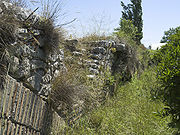
The Limyra Bridge is a late Roman bridge
in Lycia
, in modern south-west Turkey
, and one of the oldest segmented
arch bridge
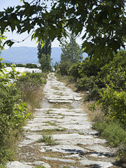
s in the world. The 360 m (1,181.1 ft) long bridge is located near the ancient city of Limyra
, and spans the Alakır Çayı river over 26 segmental arches. These arches, with a span-to-rise ratio of 5.3:1, give the bridge an unusually flat profile, and were unsurpassed as an architectural achievement until the late Middle Ages
. Despite its unique features, the bridge remains relatively unknown, and only in the 1970s did researchers from the Istanbul
branch of the German Archaeological Institute
carry out field examinations on the site.
 No information on the bridge survives from ancient
sources. The first descriptions appear in European travellers' accounts from the 19th century. The British archaeologist Charles Fellows
was the first to explore the region of Lycia, and visited the bridge in May 1840. Fellows, as well as T.A.B. Spratt and Edward Forbes, who visited the site two years later, describe it as having 25 arches. In 1882, an Austrian expedition, including Otto Benndorf
, interpreted the structure as part of an ancient road
that connected Limyra with the city of Attaleia (modern Antalya
) to the east. However, this mission failed to produce any plans or sketches of the site.
The first, and only scientific examination of the bridge was undertaken by the German archaeologists Wolfgang W. Wurster and Joachim Ganzert in two successive days in September 1973, and completed through further visits in subsequent years. Their findings were published in 1978 in the Archäologischer Anzeiger journal of the German Archaeological Institute
, with the express intent of bringing the imperiled state of the hitherto almost intact bridge into the spotlight:
In 1993, the civil engineer Colin O'Connor summarized their report in his English-language monograph
on Roman bridges, and also emphasized the exceptional character of this bridge. No further scientific examinations of the Limyra Bridge are known.
 The bridge crosses the Alakır Çayı stream, whose ancient name is unknown, 3.2 km (2 mi) east of the ruins of Limyra (distance measured from the city's theater) and 3.8 km (2.4 mi) north of the modern coastline, close to the modern road from Turunçova to Kumluca
. The local topography is dominated by the foothills of the Toçak Dağı mountains, which blend here with the alluvial bottomlands of the Bay of Finike
. In this transitional area, the bridge was built immediately above the point where the narrow river valley opens into the wide estuary plain, and where the crossing of the river during the rain period would be obstructed by high water. While the eastern end of the bridge levels off at the gravel plain, the western end abuts directly to the rising rock wall of the mountain, presumably for protection against floods. The resulting sharp bend in the course of the road could also be exploited in case of need to block the road. A modern dam, Alakır Barajı, was constructed upstream for irrigation purposes and flood protection.
Lycia did not, in contrast to other Roman province
s, possess a very developed road system
. While the north–south traffic was conducted primarily through the few river valleys, the east–west routes led, unlike today, mostly on and along the mountain ridges. This particular road, leading from Limyra over the Alakır Çayı and into the neighboring region of Pamphylia
and Attaleia, must have been of special importance, since the two regions were united in a single province, Lycia et Pamphylia
, until the 4th century. In comparison to the main arterial roads of the Roman Empire however, the roads of Lycia, were, with 3–4 m (9.8–13.1 ft) width, rather modest and confined to pedestrian and pack animal traffic. This is further corroborated by the fact that no wagon ruts are evident on the paving of the Limyra bridge, nor any traces of a parapet or breastwork.
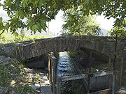
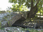 With a length of 360 m (1,181.1 ft), the Limyra Bridge qualifies as the largest surviving engineering achievement of antiquity
in Lycia. The bridge stands on 26 uniform segmental arches consisting of a double, radially laid course of bricks. At the eastern end, the original 27th arch has been replaced by two smaller, semicircular arches of later construction. The latter are built with a single course of bricks. Traces of the original, flat beginning of the collapsed arch are still visible on the piers.
At the time of Wurster's and Ganzert's visit to the site, the entire bridge was buried by river sediments up to the springing line of the vaults. No efforts to dig them up were undertaken by Wurster and Ganzert. Only two of the 28 arches were exposed enough so that direct measurements of the clear span and the pier width could be undertaken. It was, however, possible to calculate the dimensions of the remaining bays
from their exposed sections.
 The spans of the arches ranged from 11.6 m (38.1 ft) to 14.97 m (49.1 ft) (arches 2 and 26 respectively). Based on the size of the spans, one can distinguish four groups, with the following median
values:
for four arches (Nos. 2, 3, 7, 21) for fourteen arches (Nos. 5, 9–15, 17–19, 22–24) for four arches (Nos. 1, 4, 6, 8) for three arches (Nos. 16, 20, 25)
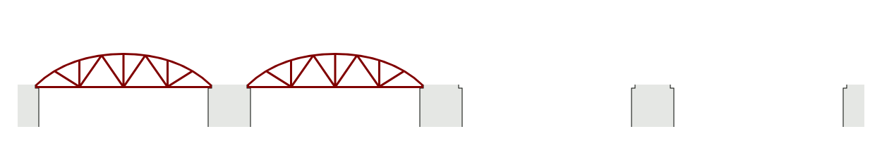
The reason for this grouping is unclear; they certainly cannot be attributed to an attempt to match the lay of the river bed. The differences however could point to the repeated use of differently-sized falsework
structures in the construction of the barrel vault
s (see animation below).
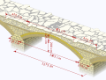
Only in a single case, between arches 26 and 27, were Wurster and Ganzert able to determine the breadth of a pier: 2.1 m (6.9 ft). Subtracting this value from the common arch span of 12.75 m (41.8 ft), a clear span of 10.65 m (34.9 ft) remains. Since all arches have a rise of ca. 2 m (6.6 ft), the Limyra Bridge has an unusually large span-to-rise ratio of . Such flattened arches were very rare at the time for stone bridges, and were not matched and surpassed until the reappearance of segmental arch bridges in 14th century Italy
. For the largest arch in the Limyra Bridge, the ratio is even greater, spanning a width 6.4 times its height. The two later arches, in contrast, are, with a ratio of 2.7:1, quite ordinary semi-circular arches.
 The total height of the bridge could not be determined because most of the structure is silted up. However, the distance between the arches' abutments and the pavement surface could be determined at only 3.25 m (10.7 ft).
The surface level is almost horizontal: the roadway lies at a height of 20.05–20.55 m (65.8–67.4 ft) above sea level
between arches 1 to 20, and falls slightly in its eastern section, between arches 21 and 26 to a level of 19.94 to 19.66 m (65.4 to 64.5 ft). Since there is no indication of a later sinking of the structure, this nearly uniform height indicates careful levelling and the existence of solid pier foundations. In contrast, the lengthwise axis of the bridge displays often significant deviations from arch to arch.
of the bridge proves the structure's great load capacity:
, stonemasonry
, and rubble
.
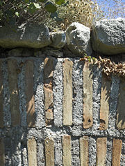 The bricks of the segmental arches are made of yellow-red clay, mixed with fine brick fragments. The bricks are rectangular plates, measuring ca. 40 × and 5 cm (2 in) thick. They are placed with the shorter side upright facing outwards, so that the total thickness of the arches measures . The bricks are bound with grout
of lime mortar mixed with brick shards and fine gravel, forming 4 cm (1.6 in)-thick joints
. The two later semi-circular arches were built with smaller bricks, although surviving bricks from the original arch were re-used at places. The abutment stones are dressed limestone ashlar
blocks, and form a sloping surface to support the arches.
The double-layer technique facilitated a more effective use of the falsework, since they could be removed and used elsewhere as soon as the lower course was finished:

consists of four layers of brick, followed by layers of rough stonemasonry bound with mortar. In contrast, between arches 22 and 26, as well as in both ramps on either end, the facing consists of ashlar blocks. The two repaired arches 27a and 27b are differentiated from the earlier work through the use of smaller unworked stones and the incorporation of irregularly placed brick tiles. In arch 26, the lower side of the arch still features a projecting bearing used for the placement of the falsework.
The interior of the superstructure consists of a combination of unworked masonry blocks and large river boulders, bound with lime mortar.
s, although smaller pebbles have been used in the repairs at the two semicircular arches.
tradition and the lack of comparable structures. Wurster and Ganzert used following characteristics as a starting point:
In contrast to these, most Roman stone bridges were faced with ashlar and rested on voussoir
arches, a method which is dominant in other vaulted structures in Lycia too. Compared to the massive and tall semicircular-arched bridges that are typical of Roman architecture
, the Limyra bridge, with its flat segmented arches, offers a markedly lower and more elongated appearance, so that Wurster and Ganzert offer a "provisional" late dating, approximately during the reign of emperor Justinian I
in the 6th century, during which the use of mixed brick and stone is attested in other structures of the region.
On the other hand, this mixed technique is already present in the 3rd-century AD aqueduct
of Aspendos
, and the Romans certainly knew how to build segmented-arched bridges, as attested by surviving examples, three of which are listed by Wurster and Ganzert themselves. An earlier construction date in the 2nd or cannot therefore be excluded. The case for an earlier construction date has been strengthened in recent years with the discovery of further seven Roman segmented arch bridges. The remnants of the nearby Kemer Bridge over the river Xanthos
, which dates to the 3rd century and has some architectural similarities with the Limyra bridge, could further reinforce that case.
Roman bridge
Roman bridges, built by ancient Romans, were the first large and lasting bridges built. Roman bridges were built with stone and had the arch as its basic structure....
in Lycia
Lycia
Lycia Lycian: Trm̃mis; ) was a region in Anatolia in what are now the provinces of Antalya and Muğla on the southern coast of Turkey. It was a federation of ancient cities in the region and later a province of the Roman Empire...
, in modern south-west Turkey
Turkey
Turkey , known officially as the Republic of Turkey , is a Eurasian country located in Western Asia and in East Thrace in Southeastern Europe...
, and one of the oldest segmented
Circular segment
In geometry, a circular segment is an area of a circle informally defined as an area which is "cut off" from the rest of the circle by a secant or a chord. The circle segment constitutes the part between the secant and an arc, excluding the circle's center...
arch bridge
Arch bridge
An arch bridge is a bridge with abutments at each end shaped as a curved arch. Arch bridges work by transferring the weight of the bridge and its loads partially into a horizontal thrust restrained by the abutments at either side...
s in the world. The 360 m (1,181.1 ft) long bridge is located near the ancient city of Limyra
Limyra
Limyra was a small city in Lycia on the southern coast of Asia Minor, on the Limyrus River, and twenty stadia from the mouth of that river.It is mentioned by Strabo , Ptolemy and several Latin authors...
, and spans the Alakır Çayı river over 26 segmental arches. These arches, with a span-to-rise ratio of 5.3:1, give the bridge an unusually flat profile, and were unsurpassed as an architectural achievement until the late Middle Ages
Middle Ages
The Middle Ages is a periodization of European history from the 5th century to the 15th century. The Middle Ages follows the fall of the Western Roman Empire in 476 and precedes the Early Modern Era. It is the middle period of a three-period division of Western history: Classic, Medieval and Modern...
. Despite its unique features, the bridge remains relatively unknown, and only in the 1970s did researchers from the Istanbul
Istanbul
Istanbul , historically known as Byzantium and Constantinople , is the largest city of Turkey. Istanbul metropolitan province had 13.26 million people living in it as of December, 2010, which is 18% of Turkey's population and the 3rd largest metropolitan area in Europe after London and...
branch of the German Archaeological Institute
German Archaeological Institute
The German Archaeological Institute is an institution of research within the field of archaeology , and a "scientific corporation", with parentage of the federal Foreign Office of Germany-Origin:...
carry out field examinations on the site.
Field examinations
Classical antiquity
Classical antiquity is a broad term for a long period of cultural history centered on the Mediterranean Sea, comprising the interlocking civilizations of ancient Greece and ancient Rome, collectively known as the Greco-Roman world...
sources. The first descriptions appear in European travellers' accounts from the 19th century. The British archaeologist Charles Fellows
Charles Fellows
Sir Charles Fellows was a British archaeologist.-Bigography:Fellows was born at Nottingham, where his family had an estate. When fourteen he drew sketches to illustrate a trip to the ruins of Newstead Abbey, which afterwards appeared on the title-page of Moore's Life of Lord Byron...
was the first to explore the region of Lycia, and visited the bridge in May 1840. Fellows, as well as T.A.B. Spratt and Edward Forbes, who visited the site two years later, describe it as having 25 arches. In 1882, an Austrian expedition, including Otto Benndorf
Otto Benndorf
Otto Benndorf was a German-Austrian archaeologist who was a native of Greiz, Thuringia.He studied theology at Erlangen, and art history and archaeology in Bonn and Göttingen. Afterwards he worked at several high schools, including Schulpforte where one of his students was Friedrich Nietzsche...
, interpreted the structure as part of an ancient road
Roman road
The Roman roads were a vital part of the development of the Roman state, from about 500 BC through the expansion during the Roman Republic and the Roman Empire. Roman roads enabled the Romans to move armies and trade goods and to communicate. The Roman road system spanned more than 400,000 km...
that connected Limyra with the city of Attaleia (modern Antalya
Antalya
Antalya is a city on the Mediterranean coast of southwestern Turkey. With a population 1,001,318 as of 2010. It is the eighth most populous city in Turkey and country's biggest international sea resort.- History :...
) to the east. However, this mission failed to produce any plans or sketches of the site.
The first, and only scientific examination of the bridge was undertaken by the German archaeologists Wolfgang W. Wurster and Joachim Ganzert in two successive days in September 1973, and completed through further visits in subsequent years. Their findings were published in 1978 in the Archäologischer Anzeiger journal of the German Archaeological Institute
German Archaeological Institute
The German Archaeological Institute is an institution of research within the field of archaeology , and a "scientific corporation", with parentage of the federal Foreign Office of Germany-Origin:...
, with the express intent of bringing the imperiled state of the hitherto almost intact bridge into the spotlight:
In 1993, the civil engineer Colin O'Connor summarized their report in his English-language monograph
Monograph
A monograph is a work of writing upon a single subject, usually by a single author.It is often a scholarly essay or learned treatise, and may be released in the manner of a book or journal article. It is by definition a single document that forms a complete text in itself...
on Roman bridges, and also emphasized the exceptional character of this bridge. No further scientific examinations of the Limyra Bridge are known.
Location and situation
Kumluca
Kumluca is a town and district of Antalya Province on the Mediterranean coast of Turkey, part of the Turkish Riviera. Kumluca is located west of the city of Antalya, on the Teke Peninsula,...
. The local topography is dominated by the foothills of the Toçak Dağı mountains, which blend here with the alluvial bottomlands of the Bay of Finike
Finike
Finike, the ancient Phoenicus , is a district on the Mediterranean coast of Antalya Province of Turkey, 90 minutes west of the city of Antalya.Finike is located in the south of the Teke peninsula, and the coast here is a popular tourist destination...
. In this transitional area, the bridge was built immediately above the point where the narrow river valley opens into the wide estuary plain, and where the crossing of the river during the rain period would be obstructed by high water. While the eastern end of the bridge levels off at the gravel plain, the western end abuts directly to the rising rock wall of the mountain, presumably for protection against floods. The resulting sharp bend in the course of the road could also be exploited in case of need to block the road. A modern dam, Alakır Barajı, was constructed upstream for irrigation purposes and flood protection.
Lycia did not, in contrast to other Roman province
Roman province
In Ancient Rome, a province was the basic, and, until the Tetrarchy , largest territorial and administrative unit of the empire's territorial possessions outside of Italy...
s, possess a very developed road system
Roman road
The Roman roads were a vital part of the development of the Roman state, from about 500 BC through the expansion during the Roman Republic and the Roman Empire. Roman roads enabled the Romans to move armies and trade goods and to communicate. The Roman road system spanned more than 400,000 km...
. While the north–south traffic was conducted primarily through the few river valleys, the east–west routes led, unlike today, mostly on and along the mountain ridges. This particular road, leading from Limyra over the Alakır Çayı and into the neighboring region of Pamphylia
Pamphylia
In ancient geography, Pamphylia was the region in the south of Asia Minor, between Lycia and Cilicia, extending from the Mediterranean to Mount Taurus . It was bounded on the north by Pisidia and was therefore a country of small extent, having a coast-line of only about 75 miles with a breadth of...
and Attaleia, must have been of special importance, since the two regions were united in a single province, Lycia et Pamphylia
Lycia et Pamphylia
Lycia et Pamphylia was the name of a province of the Roman empire, located in southern Anatolia. It was created by the emperor Vespasianus , who merged Lycia, which was organized as a province in AD 43 by Claudius, and Pamphylia, which was a part of the province of Galatia, into a single...
, until the 4th century. In comparison to the main arterial roads of the Roman Empire however, the roads of Lycia, were, with 3–4 m (9.8–13.1 ft) width, rather modest and confined to pedestrian and pack animal traffic. This is further corroborated by the fact that no wagon ruts are evident on the paving of the Limyra bridge, nor any traces of a parapet or breastwork.
Construction
Classical antiquity
Classical antiquity is a broad term for a long period of cultural history centered on the Mediterranean Sea, comprising the interlocking civilizations of ancient Greece and ancient Rome, collectively known as the Greco-Roman world...
in Lycia. The bridge stands on 26 uniform segmental arches consisting of a double, radially laid course of bricks. At the eastern end, the original 27th arch has been replaced by two smaller, semicircular arches of later construction. The latter are built with a single course of bricks. Traces of the original, flat beginning of the collapsed arch are still visible on the piers.
At the time of Wurster's and Ganzert's visit to the site, the entire bridge was buried by river sediments up to the springing line of the vaults. No efforts to dig them up were undertaken by Wurster and Ganzert. Only two of the 28 arches were exposed enough so that direct measurements of the clear span and the pier width could be undertaken. It was, however, possible to calculate the dimensions of the remaining bays
Bay (architecture)
A bay is a unit of form in architecture. This unit is defined as the zone between the outer edges of an engaged column, pilaster, or post; or within a window frame, doorframe, or vertical 'bas relief' wall form.-Defining elements:...
from their exposed sections.
Arches and piers
Median
In probability theory and statistics, a median is described as the numerical value separating the higher half of a sample, a population, or a probability distribution, from the lower half. The median of a finite list of numbers can be found by arranging all the observations from lowest value to...
values:
for four arches (Nos. 2, 3, 7, 21) for fourteen arches (Nos. 5, 9–15, 17–19, 22–24) for four arches (Nos. 1, 4, 6, 8) for three arches (Nos. 16, 20, 25)
The reason for this grouping is unclear; they certainly cannot be attributed to an attempt to match the lay of the river bed. The differences however could point to the repeated use of differently-sized falsework
Falsework
Falsework consists of temporary structures used in construction to support spanning or arched structures in order to hold the component in place until its construction is sufficiently advanced to support itself...
structures in the construction of the barrel vault
Barrel vault
A barrel vault, also known as a tunnel vault or a wagon vault, is an architectural element formed by the extrusion of a single curve along a given distance. The curves are typically circular in shape, lending a semi-cylindrical appearance to the total design...
s (see animation below).
Only in a single case, between arches 26 and 27, were Wurster and Ganzert able to determine the breadth of a pier: 2.1 m (6.9 ft). Subtracting this value from the common arch span of 12.75 m (41.8 ft), a clear span of 10.65 m (34.9 ft) remains. Since all arches have a rise of ca. 2 m (6.6 ft), the Limyra Bridge has an unusually large span-to-rise ratio of . Such flattened arches were very rare at the time for stone bridges, and were not matched and surpassed until the reappearance of segmental arch bridges in 14th century Italy
Italy
Italy , officially the Italian Republic languages]] under the European Charter for Regional or Minority Languages. In each of these, Italy's official name is as follows:;;;;;;;;), is a unitary parliamentary republic in South-Central Europe. To the north it borders France, Switzerland, Austria and...
. For the largest arch in the Limyra Bridge, the ratio is even greater, spanning a width 6.4 times its height. The two later arches, in contrast, are, with a ratio of 2.7:1, quite ordinary semi-circular arches.
Height
The surface level is almost horizontal: the roadway lies at a height of 20.05–20.55 m (65.8–67.4 ft) above sea level
Above mean sea level
The term above mean sea level refers to the elevation or altitude of any object, relative to the average sea level datum. AMSL is used extensively in radio by engineers to determine the coverage area a station will be able to reach...
between arches 1 to 20, and falls slightly in its eastern section, between arches 21 and 26 to a level of 19.94 to 19.66 m (65.4 to 64.5 ft). Since there is no indication of a later sinking of the structure, this nearly uniform height indicates careful levelling and the existence of solid pier foundations. In contrast, the lengthwise axis of the bridge displays often significant deviations from arch to arch.
Statics
Remarkably, the support line of the structure's dead load is almost identical with the curve of the vault arch. The statical analysisStatics
Statics is the branch of mechanics concerned with the analysis of loads on physical systems in static equilibrium, that is, in a state where the relative positions of subsystems do not vary over time, or where components and structures are at a constant velocity...
of the bridge proves the structure's great load capacity:
Materials
The Limyra bridge was built in a composite manner of brickBrick
A brick is a block of ceramic material used in masonry construction, usually laid using various kinds of mortar. It has been regarded as one of the longest lasting and strongest building materials used throughout history.-History:...
, stonemasonry
Stonemasonry
The craft of stonemasonry has existed since the dawn of civilization - creating buildings, structures, and sculpture using stone from the earth. These materials have been used to construct many of the long-lasting, ancient monuments, artifacts, cathedrals, and cities in a wide variety of cultures...
, and rubble
Rubble
Rubble is broken stone, of irregular size, shape and texture. This word is closely connected in derivation with "rubbish", which was formerly also applied to what we now call "rubble". Rubble naturally found in the soil is known also as brash...
.
Arches
Grout
Grout is a construction material used to embed rebars in masonry walls, connect sections of pre-cast concrete, fill voids, and seal joints . Grout is generally composed of a mixture of water, cement, sand, often color tint, and sometimes fine gravel...
of lime mortar mixed with brick shards and fine gravel, forming 4 cm (1.6 in)-thick joints
Mortar joint
In masonry, mortar joints are the spaces between bricks, concrete blocks, or glass blocks, that are filled with mortar or grout. Mortar joints can be made in a series of different fashions, but the most common ones are raked, grapevine, extruded, concave, V, struck, flush, weathered and beaded.In...
. The two later semi-circular arches were built with smaller bricks, although surviving bricks from the original arch were re-used at places. The abutment stones are dressed limestone ashlar
Ashlar
Ashlar is prepared stone work of any type of stone. Masonry using such stones laid in parallel courses is known as ashlar masonry, whereas masonry using irregularly shaped stones is known as rubble masonry. Ashlar blocks are rectangular cuboid blocks that are masonry sculpted to have square edges...
blocks, and form a sloping surface to support the arches.
The double-layer technique facilitated a more effective use of the falsework, since they could be removed and used elsewhere as soon as the lower course was finished:
Superstructure
As far as can be determined, between arches 2 to 21, the outer facing of the superstructureSuperstructure
A superstructure is an upward extension of an existing structure above a baseline. This term is applied to various kinds of physical structures such as buildings, bridges, or ships...
consists of four layers of brick, followed by layers of rough stonemasonry bound with mortar. In contrast, between arches 22 and 26, as well as in both ramps on either end, the facing consists of ashlar blocks. The two repaired arches 27a and 27b are differentiated from the earlier work through the use of smaller unworked stones and the incorporation of irregularly placed brick tiles. In arch 26, the lower side of the arch still features a projecting bearing used for the placement of the falsework.
The interior of the superstructure consists of a combination of unworked masonry blocks and large river boulders, bound with lime mortar.
Pavement
The bridge surface is located only 30–40 cm (11.8–15.7 in) over the arches' apex, is 3.55–3.7 m (11.6–12.1 ft) wide, increasing towards either end at 4.3 m (14.1 ft) and projects ca. 10 cm (3.9 in) over the superstructure on either side. It is paved with large and irregular limestone cobblestoneCobblestone
Cobblestones are stones that were frequently used in the pavement of early streets. "Cobblestone" is derived from the very old English word "cob", which had a wide range of meanings, one of which was "rounded lump" with overtones of large size...
s, although smaller pebbles have been used in the repairs at the two semicircular arches.
Dating
The exact chronological placement of the Limyra bridge is difficult due to its unique place within Roman engineeringRoman engineering
Romans are famous for their advanced engineering accomplishments, although some of their own inventions were improvements on older ideas, concepts and inventions. Technology for bringing running water into cities was developed in the east, but transformed by the Romans into a technology...
tradition and the lack of comparable structures. Wurster and Ganzert used following characteristics as a starting point:
- multiple arches of same width, and horizontal deck level with only small-gradient ramps on either end
- very flat segmental arches built with double, radially layered brick courses
- the use of mortar in the stonework
- exterior facing primarily rough masonry with interspersed bricks, partly dressed ashlar blocks
- exceptionally large paving stones.
In contrast to these, most Roman stone bridges were faced with ashlar and rested on voussoir
Voussoir
A voussoir is a wedge-shaped element, typically a stone, used in building an arch or vault.Although each unit in an arch or vault is a voussoir, two units are of distinct functional importance: the keystone and the springer. The keystone is the center stone or masonry unit at the apex of an arch. A...
arches, a method which is dominant in other vaulted structures in Lycia too. Compared to the massive and tall semicircular-arched bridges that are typical of Roman architecture
Roman architecture
Ancient Roman architecture adopted certain aspects of Ancient Greek architecture, creating a new architectural style. The Romans were indebted to their Etruscan neighbors and forefathers who supplied them with a wealth of knowledge essential for future architectural solutions, such as hydraulics...
, the Limyra bridge, with its flat segmented arches, offers a markedly lower and more elongated appearance, so that Wurster and Ganzert offer a "provisional" late dating, approximately during the reign of emperor Justinian I
Justinian I
Justinian I ; , ; 483– 13 or 14 November 565), commonly known as Justinian the Great, was Byzantine Emperor from 527 to 565. During his reign, Justinian sought to revive the Empire's greatness and reconquer the lost western half of the classical Roman Empire.One of the most important figures of...
in the 6th century, during which the use of mixed brick and stone is attested in other structures of the region.
On the other hand, this mixed technique is already present in the 3rd-century AD aqueduct
Aqueduct
An aqueduct is a water supply or navigable channel constructed to convey water. In modern engineering, the term is used for any system of pipes, ditches, canals, tunnels, and other structures used for this purpose....
of Aspendos
Aspendos
Aspendos or Aspendus was an ancient Greco-Roman city in Antalya province of Turkey. It is located northeast of central Serik.- History :...
, and the Romans certainly knew how to build segmented-arched bridges, as attested by surviving examples, three of which are listed by Wurster and Ganzert themselves. An earlier construction date in the 2nd or cannot therefore be excluded. The case for an earlier construction date has been strengthened in recent years with the discovery of further seven Roman segmented arch bridges. The remnants of the nearby Kemer Bridge over the river Xanthos
Xanthos
Xanthos was the name of a city in ancient Lycia, the site of present day Kınık, Antalya Province, Turkey, and of the river on which the city is situated...
, which dates to the 3rd century and has some architectural similarities with the Limyra bridge, could further reinforce that case.