

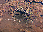
Navajo Mountain
Encyclopedia
Navajo Mountain is a peak in San Juan County, Utah
, with its southern flank extending into Coconino County, Arizona
. It holds an important place in the traditions of three local Native American
tribes.
, a dome-shaped body of igneous rock
that intruded into sedimentary
layers and lifted up the overlying layer. The igneous rock at the core of the mountain is wrapped in sedimentary layers. Such igneous intrusions have been exposed by erosion and well studied in similar mountain ranges on the Colorado Plateau
, such as the Henry Mountains
, the Abajo Mountains
, and the La Sal Range
.
 The Colorado Plateau
is made of mostly flat-lying layers of sedimentary rock that record paleoclimate extremes ranging from oceans to widespread deserts over the last 1.8 billion years. The peak of Navajo Mountain, at approximately 10388 feet (3,166 m), is made up of uplifted Dakota Sandstone
deposited during the Cretaceous
Period (approximately 66-138 million years ago).
, who know it as Naatsis’áán ("Earth Head" or "Pollen Mountain"). Together with Rainbow Bridge
to the northwest, Navajo Mountain figures prominently as the first settlement area in western Navajo origin stories. Following the military defeat of the Diné (Navajo) by United States forces in 1863, the political landscape was changed by new boundaries and major physical alterations. The establishment of Rainbow Bridge National Monument (1910), and the filling of Glen Canyon
by Lake Powell
in 1963, has facilitated tourism
of this previously remote region. Access to Navajo Mountain is still regulated by the sovereign Navajo Nation, and a permit is required to hike in the region. Climbing the mountain itself is forbidden.
Before becoming part of the Navajo Nation, the area was inhabited by the Anasazi, or Ancestral Pueblans. Their descendants, the Hopi
call Navajo Mountain Tokonave, or "Heart of the Earth". Ruins in the area of Navajo Mountain are still strongly associated with certain Hopi clans, with priests still making pilgrimages to shrines in the area.
Before 1933, when the area between the Colorado and San Juan Rivers and the Arizona border was added to the Navajo reservation, the area was known as the Paiute Strip, and the mountain itself was known as Paiute Mountain, due to the population of San Juan Paiutes living between the mountain and Monument Valley.
(Penstemon navajoa) is a rare plant limited mainly to the upper elevation slopes of Navajo Mountain.
San Juan County, Utah
As of the current census of 2010, there were 14,746 people and 4,505 households. The racial and ethnic composition of the population was 50.4% Native American, 45.8% white, 0.3% Asian, 0.2% African American and 2.3% reporting two or more races...
, with its southern flank extending into Coconino County, Arizona
Coconino County, Arizona
-2010:Whereas according to the 2010 U.S. Census Bureau:*61.7% White*1.2% Black*27.3% Native American*1.4% Asian*0.1% Native Hawaiian or Pacific Islander*3.1% Two or more races*5.2% Other races*13.5% Hispanic or Latino -2000:...
. It holds an important place in the traditions of three local Native American
Native Americans in the United States
Native Americans in the United States are the indigenous peoples in North America within the boundaries of the present-day continental United States, parts of Alaska, and the island state of Hawaii. They are composed of numerous, distinct tribes, states, and ethnic groups, many of which survive as...
tribes.
Geologic history
Navajo Mountain is a prominent free-standing laccolithLaccolith
A laccolith is a sheet intrusion that has been injected between two layers of sedimentary rock. The pressure of the magma is high enough that the overlying strata are forced upward, giving the laccolith a dome or mushroom-like form with a generally planar base.Laccoliths tend to form at relatively...
, a dome-shaped body of igneous rock
Igneous rock
Igneous rock is one of the three main rock types, the others being sedimentary and metamorphic rock. Igneous rock is formed through the cooling and solidification of magma or lava...
that intruded into sedimentary
Sedimentary rock
Sedimentary rock are types of rock that are formed by the deposition of material at the Earth's surface and within bodies of water. Sedimentation is the collective name for processes that cause mineral and/or organic particles to settle and accumulate or minerals to precipitate from a solution....
layers and lifted up the overlying layer. The igneous rock at the core of the mountain is wrapped in sedimentary layers. Such igneous intrusions have been exposed by erosion and well studied in similar mountain ranges on the Colorado Plateau
Colorado Plateau
The Colorado Plateau, also called the Colorado Plateau Province, is a physiographic region of the Intermontane Plateaus, roughly centered on the Four Corners region of the southwestern United States. The province covers an area of 337,000 km2 within western Colorado, northwestern New Mexico,...
, such as the Henry Mountains
Henry Mountains
The Henry Mountains are located in the southeastern portion of the U.S. state of Utah and run in a generally north-south direction, extending over a distance of about 30 miles . They were named by John Wesley Powell in honour of Joseph Henry, the first secretary of the Smithsonian Institution. The...
, the Abajo Mountains
Abajo Mountains
The Abajo Mountains, also called the Blue Mountains, is a small mountain range west of Monticello, Utah, south of Canyonlands National Park and north of Blanding, Utah. The mountain range is located within the Manti-La Sal National Forest...
, and the La Sal Range
La Sal Range
The La Sal Mountains are located in Grand and San Juan counties, near the eastern border of the state of Utah, and rising above the town of Moab. This range is part of the Manti-La Sal National Forest and the southern Rocky Mountains. The maximum elevation is at Mount Peale, reaching 12,721 feet ...
.
Colorado Plateau
The Colorado Plateau, also called the Colorado Plateau Province, is a physiographic region of the Intermontane Plateaus, roughly centered on the Four Corners region of the southwestern United States. The province covers an area of 337,000 km2 within western Colorado, northwestern New Mexico,...
is made of mostly flat-lying layers of sedimentary rock that record paleoclimate extremes ranging from oceans to widespread deserts over the last 1.8 billion years. The peak of Navajo Mountain, at approximately 10388 feet (3,166 m), is made up of uplifted Dakota Sandstone
Dakota Sandstone
The Dakota Sandstone is a general term for an ill-defined early Cretaceous formation of the Rocky Mountains and Great Plains. It consists of sandy, shallow-marine deposits with intermittent mud flat sediments, and occasional stream deposits...
deposited during the Cretaceous
Cretaceous
The Cretaceous , derived from the Latin "creta" , usually abbreviated K for its German translation Kreide , is a geologic period and system from circa to million years ago. In the geologic timescale, the Cretaceous follows the Jurassic period and is followed by the Paleogene period of the...
Period (approximately 66-138 million years ago).
Cultural history
The Navajo Mountain region has special cultural significance to the Navajo peopleNavajo people
The Navajo of the Southwestern United States are the largest single federally recognized tribe of the United States of America. The Navajo Nation has 300,048 enrolled tribal members. The Navajo Nation constitutes an independent governmental body which manages the Navajo Indian reservation in the...
, who know it as Naatsis’áán ("Earth Head" or "Pollen Mountain"). Together with Rainbow Bridge
Rainbow Bridge National Monument
Rainbow Bridge National Monument is administered by Glen Canyon National Recreation Area, southern Utah, USA. Rainbow Bridge is often described as the world's highest natural bridge. The span of Rainbow Bridge was reported in 1974 by the Bureau of Reclamation to be , but a laser measurement in...
to the northwest, Navajo Mountain figures prominently as the first settlement area in western Navajo origin stories. Following the military defeat of the Diné (Navajo) by United States forces in 1863, the political landscape was changed by new boundaries and major physical alterations. The establishment of Rainbow Bridge National Monument (1910), and the filling of Glen Canyon
Glen Canyon
Glen Canyon is a canyon that is located in southeastern and south central Utah and northwestern Arizona within the Vermilion Cliffs area. It was carved by the Colorado River....
by Lake Powell
Lake Powell
Lake Powell is a huge reservoir on the Colorado River, straddling the border between Utah and Arizona . It is the second largest man-made reservoir in the United States behind Lake Mead, storing of water when full...
in 1963, has facilitated tourism
Tourism
Tourism is travel for recreational, leisure or business purposes. The World Tourism Organization defines tourists as people "traveling to and staying in places outside their usual environment for not more than one consecutive year for leisure, business and other purposes".Tourism has become a...
of this previously remote region. Access to Navajo Mountain is still regulated by the sovereign Navajo Nation, and a permit is required to hike in the region. Climbing the mountain itself is forbidden.
Before becoming part of the Navajo Nation, the area was inhabited by the Anasazi, or Ancestral Pueblans. Their descendants, the Hopi
Hopi
The Hopi are a federally recognized tribe of indigenous Native American people, who primarily live on the Hopi Reservation in northeastern Arizona. The Hopi area according to the 2000 census has a population of 6,946 people. Their Hopi language is one of the 30 of the Uto-Aztecan language...
call Navajo Mountain Tokonave, or "Heart of the Earth". Ruins in the area of Navajo Mountain are still strongly associated with certain Hopi clans, with priests still making pilgrimages to shrines in the area.
Before 1933, when the area between the Colorado and San Juan Rivers and the Arizona border was added to the Navajo reservation, the area was known as the Paiute Strip, and the mountain itself was known as Paiute Mountain, due to the population of San Juan Paiutes living between the mountain and Monument Valley.
Ecology
The Navajo Mountain beardtonguePenstemon navajoa
Penstemon navajoa is a rare species of flowering plant in the plantain family known by the common name Navajo Mountain beardtongue, or Navajo beardtongue. It is endemic to Utah in the United States, where it is known only from San Juan County....
(Penstemon navajoa) is a rare plant limited mainly to the upper elevation slopes of Navajo Mountain.