
Jan Mayen
Encyclopedia
Jan Mayen Island is a volcanic island in the Arctic Ocean
and part of the Kingdom of Norway
. It is 55 km (34.2 mi) long (southwest-northeast) and 373 km2 (144 mi2) in area, partly covered by glacier
s (an area of 114.2 km2 or 44.1 mi2 around the Beerenberg
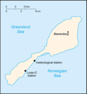
). It has two parts: larger northeast Nord-Jan and smaller Sør-Jan, linked by an isthmus
2.5 km (1.6 mi) wide. It lies 600 km (about 400 mi) northeast of Iceland
, 500 km (about 300 mi) east of central Greenland
and 1,000 km (about 600 mi) west of the North Cape, Norway
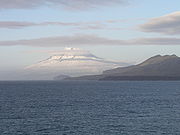
. The island is mountainous, the highest summit being the Beerenberg
volcano
in the north. The isthmus is the location of the two largest lakes of the island, Sørlaguna (South Lagoon), and Nordlaguna (North Lagoon). A third lake is called Ullerenglaguna (Ullereng Lagoon). Jan Mayen was formed by the Jan Mayen hotspot
.
. Economic activity is limited to providing services for employees of Norway
's radio communications and meteorological stations located on the island. Jan Mayen has one unpaved airstrip, Jan Mayensfield, which is about 1,585 metres (5,200 ft) long, and the 124.1 km (77.1 mi) of coast has no port
s or harbours, only offshore
anchorages.
There are important fishing
resources, and the existence of Jan Mayen establishes a large Exclusive Economic Zone
around it. A modern-day dispute between Norway
and Denmark
regarding the fishing exclusion zone between Jan Mayen and Greenland
was settled in 1988 granting Denmark the greater area of sovereignty. Significant deposits of oil and gas are suspected by geologists to lie below Jan Mayen's surrounding seafloors.
Jan Mayen Island is an integral part of the Kingdom of Norway, and it is not considered to be a dependency with some special status
. Since 1995, Jan Mayen has been administered by the County Governor
(fylkesmann) of the northern Norwegian
county of Nordland
which it is closest to. However, some authority over Jan Mayen has been assigned to the station commander of the Norwegian Defence Logistics Organisation, a branch of the Norwegian Armed Forces
.
 The only inhabitants on the island are personnel working for the Norwegian Armed Forces or the Norwegian Meteorological Institute
. There are 18 people who spend the winter on the island, but the population may double (35) during the summer, when heavy maintenance is performed. Personnel serve either six months or one year, and are exchanged twice a year in April and October. The main purpose of the military personnel is to operate a LORAN
-C base
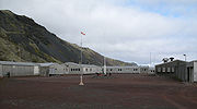
. The support crew, including mechanics, cooks and a nurse, are among the military personnel. Both the LORAN transmitter and the meteorological station are located a few kilometres away from the settlement Olonkinbyen
(English: The Olonkin City), where all personnel live.
Transport to the island is provided by C-130 Hercules
military transport planes operated by the Royal Norwegian Air Force
that land at Jan Mayensfield, which only has a gravel runway. The planes fly in from Bodø Main Air Station
eight times a year. Since the airport does not have any instrument landing capabilities, good visibility is required, and it is not uncommon for the planes to have to return to Bodø, two hours away, without landing. For heavy goods, freight ships visit during the summer, but since there are no harbours the ships must anchor up.
The island has no indigenous population, but is assigned the ISO 3166-1 alpha-2
country code
SJ (together with Svalbard
), the Internet
country code top-level domain
(ccTLD) .no
(.sj
is allocated but not used) and data code JN. Its amateur radio
call sign
prefix is JX. It has a postal code, N-8099 JAN MAYEN, but delivery time varies, especially during the winter.
, who was known as a good sailor, was close to Jan Mayen in the early 6th century. He came back from one of his voyages and reported that he had been close to a black island, which was on fire, and that there was a terrible noise in the area. He thought that he might have found the entrance to hell.
The land named Svalbarð ("cold coast") by the Viking
s in the early medieval book Landnámabók
may have been Jan Mayen (instead of Spitsbergen
, which was renamed Svalbard
by the Norwegians in modern times); the distance from Iceland to Svalbarð mentioned in this book is two days sailing, consistent with the ~530 km to Jan Mayen and not with the ~1550 km to Spitsbergen. The knowledge of Jan Mayen probably disappeared along with the Viking colonies on Greenland
around the 14th century.
In the 17th century many claims of the island's rediscovery were made, spurred by the rivalry on the Arctic whaling grounds, and the island received many names. According to Thomas Edge
, an early 17th century whaling captain who was often inaccurate, "William Hudson
" discovered the island in 1608 and named it Hudson's Touches (or Tutches). However, Henry Hudson could only have come by on his voyage in 1607 (if he had made an illogical detour) and he made no mention of it in his journal. Douglas Hunter, in Half Moon (2009), believes Hudson may not have mentioned his supposed discovery of the island because he was "loath to address a crew insurrection that might well have erupted at that time, when the men realized where he was trying to take them." This is, however, merely speculation on Hunter's part. There is absolutely no evidence to support such a claim.
According to William Scoresby
(1820: p. 154), referring to the mistaken belief that the Dutch had discovered the island in 1611, Hull
whalers discovered the island "about the same time" and named it Trinity Island. Muller (1874: pp. 190–91) took this to mean that they had come upon Jan Mayen in 1611 or 1612, which was repeated by many subsequent authors. There were, in fact, no Hull whalers in either of these years, the first Hull whaling expedition having been sent to the island only in 1616 (see below). As with the previous claim made by Edge, there is no cartographical or written proof for this supposed discovery.
 Jan Mayen was discovered in the summer of 1614, probably within one month by three separate expeditions. The Dutchman Fopp Gerritsz., while in command of a whaling expedition sent out by the Englishman John Clarke, of Dunkirk, claimed (in 1631) to have discovered the island on June 28 and named it Isabella. In January the Noordsche Compagnie
(Northern Company), modelled on the Dutch East India Company
, had been established to support Dutch whaling in the Arctic. Two of its ships, financed by merchants from Amsterdam
and Enkhuizen
, reached Jan Mayen in July 1614. The captains of these ships—Jan Jacobszoon May van Schellinkhout on the Gouden Cath (Golden Cat) and Jacob de Gouwenaer on the Orangienboom (Orange Tree)—named it Mr. Joris Eylant after the Dutch cartographer Joris Carolus
who was on board and mapped the island. The captains acknowledged that a third Dutch ship, the Cleyn Swaentgen (Little Swan) captained by Jan Jansz Kerckhoff and financed by Noordsche Compagnie shareholders from Delft
, had already been at the island when they arrived. They had assumed that the latter, who named the island Maurits Eylandt (or Mauritius) after Maurice of Nassau, Prince of Orange
, would report their discovery to the States General
. However, the Delft merchants had decided to keep the discovery secret and returned in 1615 to hunt for their own profit. The ensuing dispute was only settled in 1617, though both companies were allowed to whale at Jan Mayen in the meantime.
In 1615, Robert Fotherby
went ashore. Apparently thinking he made a new discovery, he named the island Sir Thomas Smith’s Island and the volcano “Mount Hakluyt”. Jean Vrolicq
renamed the island Île de Richelieu.
Jan Mayen first appeared on Willem Jansz Blaeu’s 1620 edition map of Europe, originally published by Cornelis Doedz in 1606. Blaeu, who lived in Amsterdam, named it Jan Mayen after captain Jan Jacobszoon May of the Amsterdam-financed Gouden Cath. Blaeu made a first detailed map of the island in his famous “Zeespiegel” atlas of 1623, establishing its current name.
That year 200 men were seasonally living and working on the island at six temporary whaling stations (spread along the northwest coast). During the first decade of whaling more than ten ships visited Jan Mayen each year, while in the second period (1624 and later) five to ten ships were sent. With the exception of a few ships from Dunkirk, which came to the island in 1617 and were either driven away or forced to give a third of their catch to the Dutch, only the Dutch and merchants from Hull sent up ships to Jan Mayen from 1616 onward. In 1624 ten wooden houses were built in South Bay
. About this time the Dutch appear to have abandoned the temporary stations consisting of tents of sail and crude furnaces, replacing them with two semi-permanent stations with wooden storehouses and dwellings and large brick furnces, one in the above-mentioned South Bay and the other in the North Bay
. In 1628 two forts were built to protect the stations. Among the sailors active at Jan Mayen was the later admiral Michiel Adriaensz de Ruyter. In 1633, at the age of 26, he was for the first time listed as an officer aboard de Groene Leeuw (The Green Lion). He again went to Jan Mayen in 1635, aboard the same ship.
In 1632 the Noordsche Compagnie expelled the Danish-employed Basque whalers from Spitsbergen. In revenge, the latter sailed to Jan Mayen, where the Dutch had left for the winter, to plunder the Dutch equipment and burn down the settlements and factories. Captain Outger Jacobsz of Grootebroek
was asked to stay the next winter (1633/34) on Jan Mayen with six shipmates to defend the island. While a group with the same task survived the winter on Spitsbergen, all seven on Jan Mayen died of scurvy
or trichinosis
(from eating raw polar bear meat) combined with the harsh conditions.
During the first phase of whaling the hauls were generally good, some exceptional. For example, Mathijs Jansz. Hoepstock caught 44 whales in Hoepstockbukta
in 1619, which produced 2,300 casks of whale oil. During the second phase the hauls were much lower. While 1631 turned out to be a very good season, the following year, due to the weather and ice, only eight whales were caught. In 1633 eleven ships managed to catch just 47 whales; while a meager 42 were caught by the same number in 1635. The Bowhead whale was locally hunted to near extinction around 1640 (approximately 1000 had been killed and processed on the island), at which time Jan Mayen was abandoned and stayed uninhabited for two and a half centuries.
 During the International Polar Year
1882-83 the Austro-Hungarian North Pole Expedition
stayed one year at Jan Mayen. The expedition performed extensive mapping of the area, their maps being of such quality that they were used until the 1950s. The Austrian polar station on Jan Mayen Island was built and equipped in 1882 fully at Count Wilczek's
own costs.
Polar bear
s appear on Jan Mayen, although in diminished numbers compared with earlier times. Between 1900 and 1920, there were a number of Norwegian trappers spending winters on Jan Mayen, hunting white and blue foxes in addition to some polar bears. But the exploitation soon made the profits decline, and the hunting ended. Polar bears are genetically distinguishable in this region of the Arctic with those from elsewhere.
The League of Nations
gave Norway jurisdiction over the island, and in 1921 Norway opened the first meteorological station. The Norwegian Meteorological Institute annexed the island for Norway in 1922. On 27 February 1930, the island was made de jure a part of the Kingdom of Norway.
During World War II, continental Norway was invaded and occupied by Germany in spring 1940. The four man team on Jan Mayen stayed at their posts and in an act of defiance began sending their weather reports to the United Kingdom instead of Norway. The British codenamed Jan Mayen Island X and attempted to reinforce it with troops to counteract any German
attack. The Norwegian gunboat Fridtjof Nansen
ran aground on one of the islands' many uncharted lava reefs and the 68 man crew abandoned ship and joined the Norwegian team on shore. The British expedition commander, prompted by the loss of the gunboat, decided to abandon Jan Mayen until the following spring and radioed for a rescue ship. Within a few days a ship arrived and evacuated the four Norwegians and their would-be reinforcements after demolishing the weather station to prevent it from falling into German hands. The Germans attempted to land a weather team on the island on 16 November 1940. The German naval trawler
carrying the team crashed on the rocks just off Jan Mayen after a patrolling British destroyer
had picked them up on radar. Most of the crew struggled ashore and were taken prisoner by a landing party from the destroyer.
 The Allies
returned to the island on 10 March 1941, when the Norwegian ship Veslekari, escorted by the patrol boat Honningsvaag, dropped 12 Norwegian weathermen on the island. The team's radio transmissions soon betrayed its presence to the Axis
, and German planes from Norway began to bomb and strafe Jan Mayen whenever weather would permit it, though they did little damage. Soon supplies and reinforcements arrived and even some antiaircraft guns, giving the island a garrison of a few dozen weathermen and soldiers. By 1941, Germany had given up hope of evicting the Allies from the island and the constant air raids stopped.
On 7 August 1942, a German Focke-Wulf Fw 200
"Condor", probably on a mission to bomb the station, smashed into the nearby mountainside of Danielsenkrateret in fog, killing all 9 crewmembers. In 1950, the wreck of another German plane with 4 crew members was discovered on the southwest side of the island. In 1943, the Americans established a radio locating station named Atlantic City in the north to try to locate German radio bases in Greenland.
After the war, the meteorological station was located at Atlantic City, but moved in 1949 to a new location. Radio Jan Mayen also served as an important radio station for ship traffic in the Arctic Ocean
. In 1959, NATO decided to build the LORAN
-C network in the Atlantic Ocean, and one of the transmitters had to be on Jan Mayen. By 1961, the new military installations, including a new airfield, were operational.
For some time, scientists doubted if there could be any activity in the Beerenberg volcano, but in 1970 the volcano erupted, and added another three square kilometres (1.2 sq mi) of land mass to the island during the three to four weeks it lasted. It had more eruptions in 1973 and 1985. During an eruption, the sea temperature around the island may increase from just above freezing to about 30 degrees Celsius (86 °F).
Historic stations and huts on the island are Hoyberg, Vera, Olsbu, Puppebu (cabin), Gamlemetten or Gamlestasjonen (the old weather station), Jan Mayen Radio, Helenehytta, Margarethhytta, and Ulla (a cabin at the foot of the Beerenberg).
volcano
with its large ice cap
(114.2 km² or 44 sq mi), which can be divided into twenty individual outlet glacier
s. The largest of those is Sørbreen, with an area of 15 km² (5.8 sq mi) and a length of 8.7 km² (3.36 sq mi). South-Jan is narrow, comparatively flat and unglaciated. Its highest elevation is Rudolftoppen with 769 m (2,523 ft). The station and living quarters are located on South-Jan. The island lies at the northern end of the Jan Mayen Microcontinent. The microcontinent
was originally part of the Greenland Plate
, but now forms part of the Eurasian Plate
.
climate, similar to Greenland and Svalbard, with a Köppen classification
of ET.
, Lara Croft
visits Jan Mayen Island in search of Thor's Hammer. The ruin that she finds there is supposedly the source of the Valhalla
myth.
In the Tom Clancy
book The Hunt for Red October
the island is mentioned as a LORAN-C station for NATO
In the movie K-19: The Widowmaker
, Captain Polenin remarks that the island has "one mountain, no trees, fifteen men, and one radio station".
Arctic Ocean
The Arctic Ocean, located in the Northern Hemisphere and mostly in the Arctic north polar region, is the smallest and shallowest of the world's five major oceanic divisions...
and part of the Kingdom of Norway
Norway
Norway , officially the Kingdom of Norway, is a Nordic unitary constitutional monarchy whose territory comprises the western portion of the Scandinavian Peninsula, Jan Mayen, and the Arctic archipelago of Svalbard and Bouvet Island. Norway has a total area of and a population of about 4.9 million...
. It is 55 km (34.2 mi) long (southwest-northeast) and 373 km2 (144 mi2) in area, partly covered by glacier
Glacier
A glacier is a large persistent body of ice that forms where the accumulation of snow exceeds its ablation over many years, often centuries. At least 0.1 km² in area and 50 m thick, but often much larger, a glacier slowly deforms and flows due to stresses induced by its weight...
s (an area of 114.2 km2 or 44.1 mi2 around the Beerenberg
Beerenberg
Beerenberg is a stratovolcano which forms the northeastern end of the Norwegian island of Jan Mayen. It is the world's northernmost subaerial active volcano...
). It has two parts: larger northeast Nord-Jan and smaller Sør-Jan, linked by an isthmus
Isthmus
An isthmus is a narrow strip of land connecting two larger land areas usually with waterforms on either side.Canals are often built through isthmuses where they may be particularly advantageous to create a shortcut for marine transportation...
2.5 km (1.6 mi) wide. It lies 600 km (about 400 mi) northeast of Iceland
Iceland
Iceland , described as the Republic of Iceland, is a Nordic and European island country in the North Atlantic Ocean, on the Mid-Atlantic Ridge. Iceland also refers to the main island of the country, which contains almost all the population and almost all the land area. The country has a population...
, 500 km (about 300 mi) east of central Greenland
Greenland
Greenland is an autonomous country within the Kingdom of Denmark, located between the Arctic and Atlantic Oceans, east of the Canadian Arctic Archipelago. Though physiographically a part of the continent of North America, Greenland has been politically and culturally associated with Europe for...
and 1,000 km (about 600 mi) west of the North Cape, Norway
North Cape, Norway
North Cape is a cape on the island of Magerøya in Northern Norway, in the municipality of Nordkapp. Its 307 m high, steep cliff is often referred to as the northernmost point of Europe, located at , 2102.3 km from the North Pole. However, the neighbouring point Knivskjellodden is actually...
. The island is mountainous, the highest summit being the Beerenberg
Beerenberg
Beerenberg is a stratovolcano which forms the northeastern end of the Norwegian island of Jan Mayen. It is the world's northernmost subaerial active volcano...
volcano
Volcano
2. Bedrock3. Conduit 4. Base5. Sill6. Dike7. Layers of ash emitted by the volcano8. Flank| 9. Layers of lava emitted by the volcano10. Throat11. Parasitic cone12. Lava flow13. Vent14. Crater15...
in the north. The isthmus is the location of the two largest lakes of the island, Sørlaguna (South Lagoon), and Nordlaguna (North Lagoon). A third lake is called Ullerenglaguna (Ullereng Lagoon). Jan Mayen was formed by the Jan Mayen hotspot
Jan Mayen hotspot
The Jan Mayen hotspot is a volcanic hotspot responsible for the volcanic activity that has formed the island of Jan Mayen in the northern Atlantic Ocean.-See also:*Beerenberg volcano...
.
Economy
Jan Mayen Island has no known exploitable natural resourcesNatural Resources
Natural Resources is a soul album released by Motown girl group Martha Reeves and the Vandellas in 1970 on the Gordy label. The album is significant for the Vietnam War ballad "I Should Be Proud" and the slow jam, "Love Guess Who"...
. Economic activity is limited to providing services for employees of Norway
Norway
Norway , officially the Kingdom of Norway, is a Nordic unitary constitutional monarchy whose territory comprises the western portion of the Scandinavian Peninsula, Jan Mayen, and the Arctic archipelago of Svalbard and Bouvet Island. Norway has a total area of and a population of about 4.9 million...
's radio communications and meteorological stations located on the island. Jan Mayen has one unpaved airstrip, Jan Mayensfield, which is about 1,585 metres (5,200 ft) long, and the 124.1 km (77.1 mi) of coast has no port
Port
A port is a location on a coast or shore containing one or more harbors where ships can dock and transfer people or cargo to or from land....
s or harbours, only offshore
Offshore construction
Offshore construction is the installation of structures and facilities in a marine environment, usually for the production and transmission of electricity, oil, gas and other resources....
anchorages.
There are important fishing
Fishing
Fishing is the activity of trying to catch wild fish. Fish are normally caught in the wild. Techniques for catching fish include hand gathering, spearing, netting, angling and trapping....
resources, and the existence of Jan Mayen establishes a large Exclusive Economic Zone
Exclusive Economic Zone
Under the law of the sea, an exclusive economic zone is a seazone over which a state has special rights over the exploration and use of marine resources, including production of energy from water and wind. It stretches from the seaward edge of the state's territorial sea out to 200 nautical...
around it. A modern-day dispute between Norway
Norway
Norway , officially the Kingdom of Norway, is a Nordic unitary constitutional monarchy whose territory comprises the western portion of the Scandinavian Peninsula, Jan Mayen, and the Arctic archipelago of Svalbard and Bouvet Island. Norway has a total area of and a population of about 4.9 million...
and Denmark
Denmark
Denmark is a Scandinavian country in Northern Europe. The countries of Denmark and Greenland, as well as the Faroe Islands, constitute the Kingdom of Denmark . It is the southernmost of the Nordic countries, southwest of Sweden and south of Norway, and bordered to the south by Germany. Denmark...
regarding the fishing exclusion zone between Jan Mayen and Greenland
Greenland
Greenland is an autonomous country within the Kingdom of Denmark, located between the Arctic and Atlantic Oceans, east of the Canadian Arctic Archipelago. Though physiographically a part of the continent of North America, Greenland has been politically and culturally associated with Europe for...
was settled in 1988 granting Denmark the greater area of sovereignty. Significant deposits of oil and gas are suspected by geologists to lie below Jan Mayen's surrounding seafloors.
Jan Mayen Island is an integral part of the Kingdom of Norway, and it is not considered to be a dependency with some special status
Possessions of Norway
Yngling-ruled , Norse-Gael kingdoms in the British Isles:*Kingdom of York *Kingdom of Dublin...
. Since 1995, Jan Mayen has been administered by the County Governor
County Governor
County Governor is a Norwegian government agency represented in 18 of the Norwegian counties responsible for a number of supervision and management duties. The Governor is the representative of the King and Government of Norway in each county, functioning as the connection between the state and...
(fylkesmann) of the northern Norwegian
Nord-Norge
North Norway or Nord-Noreg , North Sámi: Davvi-Norga) is the geographical region of northern Norway, consisting of the three counties Nordland, Troms and Finnmark, in total about 35% of the Norwegian mainland. Some of the largest towns in North Norway are Mo i Rana, Bodø, Narvik, Harstad, Tromsø...
county of Nordland
Nordland
is a county in Norway in the North Norway region, bordering Troms in the north, Nord-Trøndelag in the south, Norrbottens län in Sweden to the east, Västerbottens län to the southeast, and the Atlantic Ocean to the west. The county was formerly known as Nordlandene amt. The county administration is...
which it is closest to. However, some authority over Jan Mayen has been assigned to the station commander of the Norwegian Defence Logistics Organisation, a branch of the Norwegian Armed Forces
Norwegian Armed Forces
The Norwegian Armed Forces numbers about 23,000 personnel, including civilian employees. According to mobilisation plans , the strength during full mobilisation would be approximately 83,000 combatant personnel. Norway has mandatory military service for men and voluntary service for women...
.
Society
Norwegian Meteorological Institute
Norwegian Meteorological Institute is the Norwegian national institute for weather forecasts.The three main offices are located in Oslo, Bergen and Tromsø. The Institute has around 500 employees and keeps around 650 paid observers of various kinds around the country...
. There are 18 people who spend the winter on the island, but the population may double (35) during the summer, when heavy maintenance is performed. Personnel serve either six months or one year, and are exchanged twice a year in April and October. The main purpose of the military personnel is to operate a LORAN
LORAN
LORAN is a terrestrial radio navigation system using low frequency radio transmitters in multiple deployment to determine the location and speed of the receiver....
-C base
LORAN-C transmitter Jan Mayen
The LORAN-C transmitter Jan Mayen is a LORAN-C transmission facility on the island of Jan Mayen at . The LORAN-C transmitter Jan Mayen uses as antenna a 190-metre high guyed mast....
. The support crew, including mechanics, cooks and a nurse, are among the military personnel. Both the LORAN transmitter and the meteorological station are located a few kilometres away from the settlement Olonkinbyen
Olonkinbyen
Olonkinbyen or Olonkin City is a settlement on the Norwegian island of Jan Mayen.Olonkinbyen houses the staff that operates the weather station and the radio station. Currently there are 18 members stationed in Olonkinbyen who make up the entirety of the island's population, therefore making it...
(English: The Olonkin City), where all personnel live.
Transport to the island is provided by C-130 Hercules
C-130 Hercules
The Lockheed C-130 Hercules is a four-engine turboprop military transport aircraft designed and built originally by Lockheed, now Lockheed Martin. Capable of using unprepared runways for takeoffs and landings, the C-130 was originally designed as a troop, medical evacuation, and cargo transport...
military transport planes operated by the Royal Norwegian Air Force
Royal Norwegian Air Force
The Royal Norwegian Air Force is the air force of Norway. It was established as a separate arm of the Norwegian armed forces on 10 November 1944. The RNoAF's peace force is approximately 1,430 employees . 600 personnel also serve their draft period in the RNoAF...
that land at Jan Mayensfield, which only has a gravel runway. The planes fly in from Bodø Main Air Station
Bodø Main Air Station
Bodø Main Air Station Bodø Main Air Station Bodø Main Air Station (Norwegian: Bodø hovedflystasjon is situated just outside Bodø, Norway and is the largest air station in Norway, operated by the Royal Norwegian Air Force. The air station is home to the General Dynamics F-16 Fighting Falcons of...
eight times a year. Since the airport does not have any instrument landing capabilities, good visibility is required, and it is not uncommon for the planes to have to return to Bodø, two hours away, without landing. For heavy goods, freight ships visit during the summer, but since there are no harbours the ships must anchor up.
The island has no indigenous population, but is assigned the ISO 3166-1 alpha-2
ISO 3166-1 alpha-2
ISO 3166-1 alpha-2 codes are two-letter country codes defined in ISO 3166-1, part of the ISO 3166 standard published by the International Organization for Standardization , to represent countries, dependent territories, and special areas of geographical interest...
country code
Country code
Country codes are short alphabetic or numeric geographical codes developed to represent countries and dependent areas, for use in data processing and communications. Several different systems have been developed to do this. The best known of these is ISO 3166-1...
SJ (together with Svalbard
Svalbard
Svalbard is an archipelago in the Arctic, constituting the northernmost part of Norway. It is located north of mainland Europe, midway between mainland Norway and the North Pole. The group of islands range from 74° to 81° north latitude , and from 10° to 35° east longitude. Spitsbergen is the...
), the Internet
Internet
The Internet is a global system of interconnected computer networks that use the standard Internet protocol suite to serve billions of users worldwide...
country code top-level domain
Top-level domain
A top-level domain is one of the domains at the highest level in the hierarchical Domain Name System of the Internet. The top-level domain names are installed in the root zone of the name space. For all domains in lower levels, it is the last part of the domain name, that is, the last label of a...
(ccTLD) .no
.no
.no is the Internet country code top-level domain for Norway. Registrations are processed via accredited registrars and internationalized domain names may also be registered ....
(.sj
.sj
.sj is the Internet country code top-level domain reserved for the designation Svalbard and Jan Mayen. The domain name registry is Norid, but .sj is not open for registration...
is allocated but not used) and data code JN. Its amateur radio
Amateur radio
Amateur radio is the use of designated radio frequency spectrum for purposes of private recreation, non-commercial exchange of messages, wireless experimentation, self-training, and emergency communication...
call sign
Call sign
In broadcasting and radio communications, a call sign is a unique designation for a transmitting station. In North America they are used as names for broadcasting stations...
prefix is JX. It has a postal code, N-8099 JAN MAYEN, but delivery time varies, especially during the winter.
Unverified discoveries
The first known discovery of the island was in 1614. There are claims of earlier discoveries: some historians believe that an Irish monk, BrendanBrendan
Saint Brendan of Clonfert or Bréanainn of Clonfert called "the Navigator", "the Voyager", or "the Bold" is one of the early Irish monastic saints. He is chiefly renowned for his legendary quest to the "Isle of the Blessed," also called St. Brendan's Island. The Voyage of St...
, who was known as a good sailor, was close to Jan Mayen in the early 6th century. He came back from one of his voyages and reported that he had been close to a black island, which was on fire, and that there was a terrible noise in the area. He thought that he might have found the entrance to hell.
The land named Svalbarð ("cold coast") by the Viking
Viking
The term Viking is customarily used to refer to the Norse explorers, warriors, merchants, and pirates who raided, traded, explored and settled in wide areas of Europe, Asia and the North Atlantic islands from the late 8th to the mid-11th century.These Norsemen used their famed longships to...
s in the early medieval book Landnámabók
Landnámabók
Landnámabók , often shortened to Landnáma, is a medieval Icelandic written work describing in considerable detail the settlement of Iceland by the Norse in the 9th and 10th centuries AD.-Landnáma:...
may have been Jan Mayen (instead of Spitsbergen
Spitsbergen
Spitsbergen is the largest and only permanently populated island of the Svalbard archipelago in Norway. Constituting the western-most bulk of the archipelago, it borders the Arctic Ocean, the Norwegian Sea and the Greenland Sea...
, which was renamed Svalbard
Svalbard
Svalbard is an archipelago in the Arctic, constituting the northernmost part of Norway. It is located north of mainland Europe, midway between mainland Norway and the North Pole. The group of islands range from 74° to 81° north latitude , and from 10° to 35° east longitude. Spitsbergen is the...
by the Norwegians in modern times); the distance from Iceland to Svalbarð mentioned in this book is two days sailing, consistent with the ~530 km to Jan Mayen and not with the ~1550 km to Spitsbergen. The knowledge of Jan Mayen probably disappeared along with the Viking colonies on Greenland
Greenland
Greenland is an autonomous country within the Kingdom of Denmark, located between the Arctic and Atlantic Oceans, east of the Canadian Arctic Archipelago. Though physiographically a part of the continent of North America, Greenland has been politically and culturally associated with Europe for...
around the 14th century.
In the 17th century many claims of the island's rediscovery were made, spurred by the rivalry on the Arctic whaling grounds, and the island received many names. According to Thomas Edge
Thomas Edge
Thomas Edge was an English merchant, whaler, and sealer who worked for the Muscovy Company in the first quarter of the 17th century. Edge was born in the parish of Blackburn, Lancashire in 1587/88. His father was Ellis Edge. Edgeøya is named after him...
, an early 17th century whaling captain who was often inaccurate, "William Hudson
Henry Hudson
Henry Hudson was an English sea explorer and navigator in the early 17th century. Hudson made two attempts on behalf of English merchants to find a prospective Northeast Passage to Cathay via a route above the Arctic Circle...
" discovered the island in 1608 and named it Hudson's Touches (or Tutches). However, Henry Hudson could only have come by on his voyage in 1607 (if he had made an illogical detour) and he made no mention of it in his journal. Douglas Hunter, in Half Moon (2009), believes Hudson may not have mentioned his supposed discovery of the island because he was "loath to address a crew insurrection that might well have erupted at that time, when the men realized where he was trying to take them." This is, however, merely speculation on Hunter's part. There is absolutely no evidence to support such a claim.
According to William Scoresby
William Scoresby
William Scoresby , was an English Arctic explorer, scientist and clergyman.-Early years:Scoresby was born in the village of Cropton near Pickering 26 miles south of Whitby in Yorkshire. His father, William Scoresby , made a fortune in the Arctic whale fishery...
(1820: p. 154), referring to the mistaken belief that the Dutch had discovered the island in 1611, Hull
Kingston upon Hull
Kingston upon Hull , usually referred to as Hull, is a city and unitary authority area in the ceremonial county of the East Riding of Yorkshire, England. It stands on the River Hull at its junction with the Humber estuary, 25 miles inland from the North Sea. Hull has a resident population of...
whalers discovered the island "about the same time" and named it Trinity Island. Muller (1874: pp. 190–91) took this to mean that they had come upon Jan Mayen in 1611 or 1612, which was repeated by many subsequent authors. There were, in fact, no Hull whalers in either of these years, the first Hull whaling expedition having been sent to the island only in 1616 (see below). As with the previous claim made by Edge, there is no cartographical or written proof for this supposed discovery.
1614 discoveries and final naming
Noordsche Compagnie
The Noordsche or Groenlandse Compagnie was a cartel for whaling, founded by several cities in the Netherlands...
(Northern Company), modelled on the Dutch East India Company
Dutch East India Company
The Dutch East India Company was a chartered company established in 1602, when the States-General of the Netherlands granted it a 21-year monopoly to carry out colonial activities in Asia...
, had been established to support Dutch whaling in the Arctic. Two of its ships, financed by merchants from Amsterdam
Amsterdam
Amsterdam is the largest city and the capital of the Netherlands. The current position of Amsterdam as capital city of the Kingdom of the Netherlands is governed by the constitution of August 24, 1815 and its successors. Amsterdam has a population of 783,364 within city limits, an urban population...
and Enkhuizen
Enkhuizen
Enkhuizen is a municipality and a town in the Netherlands, in the province of North Holland and the region of West-Frisia.Enkhuizen was one of the harbour-towns of the VOC, just like Hoorn and Amsterdam, from where overseas trade with the East Indies was conducted. It received city rights in 1355...
, reached Jan Mayen in July 1614. The captains of these ships—Jan Jacobszoon May van Schellinkhout on the Gouden Cath (Golden Cat) and Jacob de Gouwenaer on the Orangienboom (Orange Tree)—named it Mr. Joris Eylant after the Dutch cartographer Joris Carolus
Joris Carolus
Joris Carolus was a Dutch cartographer and explorer. He served for both the Noordsche Compagnie and the Vereenigde Oost-Indische Compagnie .-Career:...
who was on board and mapped the island. The captains acknowledged that a third Dutch ship, the Cleyn Swaentgen (Little Swan) captained by Jan Jansz Kerckhoff and financed by Noordsche Compagnie shareholders from Delft
Delft
Delft is a city and municipality in the province of South Holland , the Netherlands. It is located between Rotterdam and The Hague....
, had already been at the island when they arrived. They had assumed that the latter, who named the island Maurits Eylandt (or Mauritius) after Maurice of Nassau, Prince of Orange
Maurice of Nassau, Prince of Orange
Maurice of Nassau, Prince of Orange was sovereign Prince of Orange from 1618, on the death of his eldest half brother, Philip William, Prince of Orange,...
, would report their discovery to the States General
States-General of the Netherlands
The States-General of the Netherlands is the bicameral legislature of the Netherlands, consisting of the Senate and the House of Representatives. The parliament meets in at the Binnenhof in The Hague. The archaic Dutch word "staten" originally related to the feudal classes in which medieval...
. However, the Delft merchants had decided to keep the discovery secret and returned in 1615 to hunt for their own profit. The ensuing dispute was only settled in 1617, though both companies were allowed to whale at Jan Mayen in the meantime.
In 1615, Robert Fotherby
Robert Fotherby
Robert Fotherby was an early 17th century English explorer and whaler. From 1613 to 1615 he worked for the Muscovy Company, and from 1615 until his death for the East India Company.-Family Ties:...
went ashore. Apparently thinking he made a new discovery, he named the island Sir Thomas Smith’s Island and the volcano “Mount Hakluyt”. Jean Vrolicq
Jean Vrolicq
Jean Vrolicq was a mariner from St-Jean-de-Luz in the first half of the 17th century...
renamed the island Île de Richelieu.
Jan Mayen first appeared on Willem Jansz Blaeu’s 1620 edition map of Europe, originally published by Cornelis Doedz in 1606. Blaeu, who lived in Amsterdam, named it Jan Mayen after captain Jan Jacobszoon May of the Amsterdam-financed Gouden Cath. Blaeu made a first detailed map of the island in his famous “Zeespiegel” atlas of 1623, establishing its current name.
Jan Mayen as a Dutch whaling base
From 1615 to 1638, Jan Mayen was used as a whaling base by the Dutch Noordsche Compagnie, which had been given a monopoly on whaling in the Arctic regions by the States General in 1614. Only two ships, one from the Noordsche Compagnie, and the other from the Delft merchants, were off Jan Mayen in 1615. The following year a score of vessels were sent to the island. The Noordsche Compagnie sent eight ships escorted by three warships under Jan Jacobsz. Schrobop; while the Delft merchants sent up five ships under Adriaen Dircksz. Leversteyn, son of one of the above merchants. There were also two ships from Dunkirk sent by John Clarke, as well as a ship each from London and Hull. Heertje Jansz, master of the Hope, of Enkhuizen, wrote a day-by-day account of the season. The ships took two weeks to reach Jan Mayen, arriving early in June. On 15 June they met the two English ships, which Schrobop allowed to remain, on condition they gave half their catch to the Dutch. The ships from Dunkirk were given the same conditions. By late July the first ship had left with a full cargo of oil; the rest left early in August, several filled with oil.That year 200 men were seasonally living and working on the island at six temporary whaling stations (spread along the northwest coast). During the first decade of whaling more than ten ships visited Jan Mayen each year, while in the second period (1624 and later) five to ten ships were sent. With the exception of a few ships from Dunkirk, which came to the island in 1617 and were either driven away or forced to give a third of their catch to the Dutch, only the Dutch and merchants from Hull sent up ships to Jan Mayen from 1616 onward. In 1624 ten wooden houses were built in South Bay
Titeltbukta
Titeltbukta is a bay on the northwestern coast of the island of Jan Mayen. The name originates from the establishment of ten "tents" in the bay in 1624 by Dutch whalers to lodge the men who flensed the whales. The Dutch also called it Zuidbaai , as it was the most southerly of the whaling bays...
. About this time the Dutch appear to have abandoned the temporary stations consisting of tents of sail and crude furnaces, replacing them with two semi-permanent stations with wooden storehouses and dwellings and large brick furnces, one in the above-mentioned South Bay and the other in the North Bay
Engelskbukta (Jan Mayen)
Engelskbukta is a broad, open bay mid-way up the west coast of the island of Jan Mayen. It lies between Kapp Rudsen and Kvalrossen, comprising Kvalrossbukta and Tømmerbukta. Presumably this is where the English resorted to in 1616, when they sent their first whaling ships to the island. The Dutch...
. In 1628 two forts were built to protect the stations. Among the sailors active at Jan Mayen was the later admiral Michiel Adriaensz de Ruyter. In 1633, at the age of 26, he was for the first time listed as an officer aboard de Groene Leeuw (The Green Lion). He again went to Jan Mayen in 1635, aboard the same ship.
In 1632 the Noordsche Compagnie expelled the Danish-employed Basque whalers from Spitsbergen. In revenge, the latter sailed to Jan Mayen, where the Dutch had left for the winter, to plunder the Dutch equipment and burn down the settlements and factories. Captain Outger Jacobsz of Grootebroek
Grootebroek
Grootebroek is a town in the Dutch province of North Holland. It is located in the municipality of Stede Broec.Grootebroek was a separate municipality until 1979....
was asked to stay the next winter (1633/34) on Jan Mayen with six shipmates to defend the island. While a group with the same task survived the winter on Spitsbergen, all seven on Jan Mayen died of scurvy
Scurvy
Scurvy is a disease resulting from a deficiency of vitamin C, which is required for the synthesis of collagen in humans. The chemical name for vitamin C, ascorbic acid, is derived from the Latin name of scurvy, scorbutus, which also provides the adjective scorbutic...
or trichinosis
Trichinosis
Trichinosis, also called trichinellosis, or trichiniasis, is a parasitic disease caused by eating raw or undercooked pork or wild game infected with the larvae of a species of roundworm Trichinella spiralis, commonly called the trichina worm. There are eight Trichinella species; five are...
(from eating raw polar bear meat) combined with the harsh conditions.
During the first phase of whaling the hauls were generally good, some exceptional. For example, Mathijs Jansz. Hoepstock caught 44 whales in Hoepstockbukta
Hoepstockbukta
Hoepstockbukta is a small cove on the western coast of the island of Jan Mayen. The cove is named after Mathijs Jansz. Hoepstock, a Rotterdam whaler who was the first to use the bay in 1616. The cove is shown on Joan Blaeu's 1662 map of the island.-References:* Norwegian Polar Institute...
in 1619, which produced 2,300 casks of whale oil. During the second phase the hauls were much lower. While 1631 turned out to be a very good season, the following year, due to the weather and ice, only eight whales were caught. In 1633 eleven ships managed to catch just 47 whales; while a meager 42 were caught by the same number in 1635. The Bowhead whale was locally hunted to near extinction around 1640 (approximately 1000 had been killed and processed on the island), at which time Jan Mayen was abandoned and stayed uninhabited for two and a half centuries.
19th and 20th century
International Polar Year
The International Polar Year is a collaborative, international effort researching the polar regions. Karl Weyprecht, an Austro-Hungarian naval officer, motivated the endeavor, but died before it first occurred in 1882-1883. Fifty years later a second IPY occurred...
1882-83 the Austro-Hungarian North Pole Expedition
Austro-Hungarian North Pole Expedition
The Austro-Hungarian North Pole Expedition was an expedition that ran from 1872–74 and discovered Franz-Josef Land. According to Julius von Payer, one of the leaders, the journey was to find the north-eastern passage. It actually explored the area northwest of Novaya Zemlya. According to the...
stayed one year at Jan Mayen. The expedition performed extensive mapping of the area, their maps being of such quality that they were used until the 1950s. The Austrian polar station on Jan Mayen Island was built and equipped in 1882 fully at Count Wilczek's
Count Johann Nepomuk Wilczek
Count Johann Nepomuk Wilczek was an Austro-Hungarian sponsor of Polar expeditions and artists....
own costs.
Polar bear
Polar Bear
The polar bear is a bear native largely within the Arctic Circle encompassing the Arctic Ocean, its surrounding seas and surrounding land masses. It is the world's largest land carnivore and also the largest bear, together with the omnivorous Kodiak Bear, which is approximately the same size...
s appear on Jan Mayen, although in diminished numbers compared with earlier times. Between 1900 and 1920, there were a number of Norwegian trappers spending winters on Jan Mayen, hunting white and blue foxes in addition to some polar bears. But the exploitation soon made the profits decline, and the hunting ended. Polar bears are genetically distinguishable in this region of the Arctic with those from elsewhere.
The League of Nations
League of Nations
The League of Nations was an intergovernmental organization founded as a result of the Paris Peace Conference that ended the First World War. It was the first permanent international organization whose principal mission was to maintain world peace...
gave Norway jurisdiction over the island, and in 1921 Norway opened the first meteorological station. The Norwegian Meteorological Institute annexed the island for Norway in 1922. On 27 February 1930, the island was made de jure a part of the Kingdom of Norway.
During World War II, continental Norway was invaded and occupied by Germany in spring 1940. The four man team on Jan Mayen stayed at their posts and in an act of defiance began sending their weather reports to the United Kingdom instead of Norway. The British codenamed Jan Mayen Island X and attempted to reinforce it with troops to counteract any German
Nazi Germany
Nazi Germany , also known as the Third Reich , but officially called German Reich from 1933 to 1943 and Greater German Reich from 26 June 1943 onward, is the name commonly used to refer to the state of Germany from 1933 to 1945, when it was a totalitarian dictatorship ruled by...
attack. The Norwegian gunboat Fridtjof Nansen
HNoMS Fridtjof Nansen OPV
HNoMS Fridtjof Nansen was the first ship in the Norwegian armed forces to be built specially to perform coast guard and fishery protection duties in the Arctic...
ran aground on one of the islands' many uncharted lava reefs and the 68 man crew abandoned ship and joined the Norwegian team on shore. The British expedition commander, prompted by the loss of the gunboat, decided to abandon Jan Mayen until the following spring and radioed for a rescue ship. Within a few days a ship arrived and evacuated the four Norwegians and their would-be reinforcements after demolishing the weather station to prevent it from falling into German hands. The Germans attempted to land a weather team on the island on 16 November 1940. The German naval trawler
Naval trawler
A naval trawler is a vessel built along the lines of a fishing trawler but fitted out for naval purposes. Naval trawlers were widely used during the First and Second world wars. Fishing trawlers were particularly suited for many naval requirements because they were robust boats designed to work...
carrying the team crashed on the rocks just off Jan Mayen after a patrolling British destroyer
Destroyer
In naval terminology, a destroyer is a fast and maneuverable yet long-endurance warship intended to escort larger vessels in a fleet, convoy or battle group and defend them against smaller, powerful, short-range attackers. Destroyers, originally called torpedo-boat destroyers in 1892, evolved from...
had picked them up on radar. Most of the crew struggled ashore and were taken prisoner by a landing party from the destroyer.
Allies
In everyday English usage, allies are people, groups, or nations that have joined together in an association for mutual benefit or to achieve some common purpose, whether or not explicit agreement has been worked out between them...
returned to the island on 10 March 1941, when the Norwegian ship Veslekari, escorted by the patrol boat Honningsvaag, dropped 12 Norwegian weathermen on the island. The team's radio transmissions soon betrayed its presence to the Axis
Axis Powers
The Axis powers , also known as the Axis alliance, Axis nations, Axis countries, or just the Axis, was an alignment of great powers during the mid-20th century that fought World War II against the Allies. It began in 1936 with treaties of friendship between Germany and Italy and between Germany and...
, and German planes from Norway began to bomb and strafe Jan Mayen whenever weather would permit it, though they did little damage. Soon supplies and reinforcements arrived and even some antiaircraft guns, giving the island a garrison of a few dozen weathermen and soldiers. By 1941, Germany had given up hope of evicting the Allies from the island and the constant air raids stopped.
On 7 August 1942, a German Focke-Wulf Fw 200
Focke-Wulf Fw 200
The Focke-Wulf Fw 200 Condor, also known as Kurier to the Allies was a German all-metal four-engine monoplane originally developed by Focke-Wulf as a long-range airliner...
"Condor", probably on a mission to bomb the station, smashed into the nearby mountainside of Danielsenkrateret in fog, killing all 9 crewmembers. In 1950, the wreck of another German plane with 4 crew members was discovered on the southwest side of the island. In 1943, the Americans established a radio locating station named Atlantic City in the north to try to locate German radio bases in Greenland.
After the war, the meteorological station was located at Atlantic City, but moved in 1949 to a new location. Radio Jan Mayen also served as an important radio station for ship traffic in the Arctic Ocean
Arctic Ocean
The Arctic Ocean, located in the Northern Hemisphere and mostly in the Arctic north polar region, is the smallest and shallowest of the world's five major oceanic divisions...
. In 1959, NATO decided to build the LORAN
LORAN
LORAN is a terrestrial radio navigation system using low frequency radio transmitters in multiple deployment to determine the location and speed of the receiver....
-C network in the Atlantic Ocean, and one of the transmitters had to be on Jan Mayen. By 1961, the new military installations, including a new airfield, were operational.
For some time, scientists doubted if there could be any activity in the Beerenberg volcano, but in 1970 the volcano erupted, and added another three square kilometres (1.2 sq mi) of land mass to the island during the three to four weeks it lasted. It had more eruptions in 1973 and 1985. During an eruption, the sea temperature around the island may increase from just above freezing to about 30 degrees Celsius (86 °F).
Historic stations and huts on the island are Hoyberg, Vera, Olsbu, Puppebu (cabin), Gamlemetten or Gamlestasjonen (the old weather station), Jan Mayen Radio, Helenehytta, Margarethhytta, and Ulla (a cabin at the foot of the Beerenberg).
Geography and geology
Jan Mayen consists of two geographically distinct parts. Nord-Jan has a round shape and is dominated by the 2277 m (7,470 ft) high BeerenbergBeerenberg
Beerenberg is a stratovolcano which forms the northeastern end of the Norwegian island of Jan Mayen. It is the world's northernmost subaerial active volcano...
volcano
Volcano
2. Bedrock3. Conduit 4. Base5. Sill6. Dike7. Layers of ash emitted by the volcano8. Flank| 9. Layers of lava emitted by the volcano10. Throat11. Parasitic cone12. Lava flow13. Vent14. Crater15...
with its large ice cap
Ice cap
An ice cap is an ice mass that covers less than 50 000 km² of land area . Masses of ice covering more than 50 000 km² are termed an ice sheet....
(114.2 km² or 44 sq mi), which can be divided into twenty individual outlet glacier
Glacier
A glacier is a large persistent body of ice that forms where the accumulation of snow exceeds its ablation over many years, often centuries. At least 0.1 km² in area and 50 m thick, but often much larger, a glacier slowly deforms and flows due to stresses induced by its weight...
s. The largest of those is Sørbreen, with an area of 15 km² (5.8 sq mi) and a length of 8.7 km² (3.36 sq mi). South-Jan is narrow, comparatively flat and unglaciated. Its highest elevation is Rudolftoppen with 769 m (2,523 ft). The station and living quarters are located on South-Jan. The island lies at the northern end of the Jan Mayen Microcontinent. The microcontinent
Continental fragment
Continental crustal fragments, partially synonymous with microcontinents, are fragments of continents thought to have been broken off from the main continental mass forming distinct islands, possibly several hundred kilometers from their place of origin...
was originally part of the Greenland Plate
Greenland Plate
The Greenland Plate is a supposed tectonic plate bounded to the west by Nares Strait, a probable transform fault, on the southwest by the Ungava transform underlying Davis Strait, on the southeast by the Mid-Atlantic Ridge, and the northeast by the Gakkel Ridge, with its northwest border is still...
, but now forms part of the Eurasian Plate
Eurasian Plate
The Eurasian Plate is a tectonic plate which includes most of the continent of Eurasia , with the notable exceptions of the Indian subcontinent, the Arabian subcontinent, and the area east of the Chersky Range in East Siberia...
.
Climate
Jan Mayen has an arcticClimate of the Arctic
The climate of the Arctic is characterized by long, cold winters and short, cool summers. There is a large amount of variability in climate across the Arctic, but all regions experience extremes of solar radiation in both summer and winter...
climate, similar to Greenland and Svalbard, with a Köppen classification
Köppen climate classification
The Köppen climate classification is one of the most widely used climate classification systems. It was first published by Crimea German climatologist Wladimir Köppen in 1884, with several later modifications by Köppen himself, notably in 1918 and 1936...
of ET.
In popular culture
In the 2008 game Tomb Raider: UnderworldTomb Raider: Underworld
Tomb Raider: Underworld is the eighth instalment of the Tomb Raider series. The story continues from the events in Tomb Raider: Legend as a direct sequel, but also addresses unexplained plot elements by association with Tomb Raider: Anniversary; the 2007 remake of the original Tomb Raider...
, Lara Croft
Lara Croft
Lara Croft is a fictional character and the protagonist of the Square Enix video game series Tomb Raider. She is presented as a beautiful, intelligent, and athletic British archaeologist-adventurer who ventures into ancient, hazardous tombs and ruins around the world...
visits Jan Mayen Island in search of Thor's Hammer. The ruin that she finds there is supposedly the source of the Valhalla
Valhalla
In Norse mythology, Valhalla is a majestic, enormous hall located in Asgard, ruled over by the god Odin. Chosen by Odin, half of those that die in combat travel to Valhalla upon death, led by valkyries, while the other half go to the goddess Freyja's field Fólkvangr...
myth.
In the Tom Clancy
Tom Clancy
Thomas Leo "Tom" Clancy, Jr. is an American author, best known for his technically detailed espionage, military science, and techno thriller storylines set during and in the aftermath of the Cold War, along with video games on which he did not work, but which bear his name for licensing and...
book The Hunt for Red October
The Hunt for Red October
The Hunt for Red October is a 1984 novel by Tom Clancy. The story follows the intertwined adventures of Soviet submarine captain Marko Aleksandrovich Ramius and CIA analyst Jack Ryan.The novel was originally published by the U.S...
the island is mentioned as a LORAN-C station for NATO
In the movie K-19: The Widowmaker
K-19: The Widowmaker
K-19: The Widowmaker is a movie released on July 19, 2002, about the first of many disasters that befell the Soviet submarine of the same name. The film was directed by Kathryn Bigelow...
, Captain Polenin remarks that the island has "one mountain, no trees, fifteen men, and one radio station".
See also
- List of islands of Norway by area#Outside the mainland of Norway
External links
- Photographs and information on Jan Mayen
- Satellite Radar image of Jan Mayen
- – website by station crew; in English and Norwegian, with many details photographs
- Glaciers of Jan Mayen
- Weather forecasts for Jan Mayen at yr.no (Norwegian Meteorological institute and NRK)
- Weather statistics for Jan Mayen at yr.no