
New York State Route 303
Encyclopedia
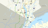
New York State Route 303 (NY 303) is a north–south state highway
in eastern Rockland County, New York
, in the United States. It begins at the New Jersey
state line in the hamlet of Tappan
and ends 10.92 miles (17.57 km) later at an intersection with U.S. Route 9W (US 9W) in Clarkstown
. NY 303 intersects the Palisades Interstate Parkway
and the New York State Thruway
, the latter carrying Interstate 87 (I-87) and I-287
.
 NY 303 begins at the New Jersey
–New York
border in Tappan
, a hamlet in the town of Orangetown
. Directly south of the border is Bergen County, New Jersey
, in which NY 303 continues as County Route 505
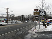
(CR 505). NY 303 begins as a four-lane route with mostly full access, and it retains this status until Valley Cottage
. As it progresses northward, it intersects the Palisades Interstate Parkway
(PIP) at exit 5 in Tappan. The interchange is the southernmost New York exit along the PIP. Right after the PIP junction, NY 303 enters Orangeburg
, where it intersects the signed northern terminus of NY 340
. NY 303 also intersects CR 20 at this location. At these intersections, NY 303 connects to St. Thomas Aquinas College
and Dominican College
by way of NY 340 and CR 20, respectively.
The route continues northward into Blauvelt
, where it runs along the western border of Clausland Mountain County Park, Blauvelt State Park
, and other town parks. While in Blauvelt, NY 303 briefly overlaps with CR 11, a mostly parallel county route that veers west to avoid the state park. Past CR 11, NY 303 proceeds north into the town of Clarkstown
and the hamlet of Central Nyack, home to NY 303's interchange with NY 59
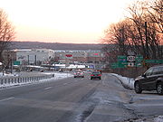
. After the interchange, NY 303 passes Palisades Center
and intersects the New York State Thruway
(I-87
and I-287
) at exit 12.
Just after Palisades Center, NY 303 briefly turns from a four-lane road to a four-lane divided highway
in Valley Cottage
. This is short-lived, however, as NY 303 reverts to a two-lane undivided route at an intersection with Storms Road. Farther north, NY 303 enters the vicinity of Congers
, passing east of Congers Lake prior to intersecting CR 80
. Past this point, NY 303 proceeds toward its northern terminus at US 9W
. NY 303 ends in northern Clarkstown, less than 1 miles (1.6 km) from the Haverstraw
town line and NY 304
's northern terminus. The intersection between NY 303 and US 9W is roughly 0.7 miles (1.1 km) south of where US 9W connects to NY 304.
 NY 303 was assigned as part of the 1930 renumbering of state highways in New York. The route initially followed its current alignment from the New Jersey
state line north to Orangeburg
, where it continued northward on Greenbush Road to its end in Central Nyack. North of this point, NY 303 followed Kings Highway and Old Haverstraw Road to US 9W
near Congers
. It was moved onto its current alignment south of Central Nyack by 1932 and shifted onto its modern routing north of Central Nyack ca. 1936.
The interchange with the New York State Thruway
was redesigned to accommodate the addition of Palisades Center
. The mall was built where the formerly proposed interchange with the New Jersey Turnpike
's Northern Extension was originally supposed to terminate.
The northern terminus at US 9W was previously a "Y" interchange with only a northbound ramp to Route 9W and a southbound ramp from 9W. This interchange was torn down in the late 1980s.
State highway
State highway, state road or state route can refer to one of three related concepts, two of them related to a state or provincial government in a country that is divided into states or provinces :#A...
in eastern Rockland County, New York
Rockland County, New York
Rockland County is a suburban county 15 miles to the northwest of Manhattan and part of the New York City Metropolitan Area, in the U.S. state of New York. It is the southernmost county in New York west of the Hudson River, and the smallest county in New York outside of New York City. The...
, in the United States. It begins at the New Jersey
New Jersey
New Jersey is a state in the Northeastern and Middle Atlantic regions of the United States. , its population was 8,791,894. It is bordered on the north and east by the state of New York, on the southeast and south by the Atlantic Ocean, on the west by Pennsylvania and on the southwest by Delaware...
state line in the hamlet of Tappan
Tappan, New York
Tappan is a hamlet in the Town of Orangetown, Rockland County, New York, United States located north of Old Tappan, New Jersey; east of Nauraushaun and Pearl River; south of Blauvelt and west of Palisades and Sparkill...
and ends 10.92 miles (17.57 km) later at an intersection with U.S. Route 9W (US 9W) in Clarkstown
Clarkstown, New York
Clarkstown is a town in Rockland County, New York, United States. The town is on the eastern border of the county, located north of the town of Orangetown; east of the town of Ramapo; South of the town of Haverstraw and west of the Hudson River. As of the 2000 census, the town had a total...
. NY 303 intersects the Palisades Interstate Parkway
Palisades Interstate Parkway
The Palisades Interstate Parkway is a long limited-access highway in the U.S. states of New Jersey and New York. The parkway is a major commuter route into New York City from Rockland and Orange counties in New York and Bergen County in New Jersey...
and the New York State Thruway
New York State Thruway
The New York State Thruway is a system of limited-access highways located within the state of New York in the United States. The system, known officially as the Governor Thomas E. Dewey Thruway for former New York Governor Thomas E. Dewey, is operated by the New York State Thruway Authority and...
, the latter carrying Interstate 87 (I-87) and I-287
Interstate 287
Interstate 287 is an auxiliary Interstate Highway in the U.S. states of New Jersey and New York. It is a partial beltway around New York City, serving the northern half of New Jersey and the counties of Rockland and Westchester in New York...
.
Route description
New Jersey
New Jersey is a state in the Northeastern and Middle Atlantic regions of the United States. , its population was 8,791,894. It is bordered on the north and east by the state of New York, on the southeast and south by the Atlantic Ocean, on the west by Pennsylvania and on the southwest by Delaware...
–New York
New York
New York is a state in the Northeastern region of the United States. It is the nation's third most populous state. New York is bordered by New Jersey and Pennsylvania to the south, and by Connecticut, Massachusetts and Vermont to the east...
border in Tappan
Tappan, New York
Tappan is a hamlet in the Town of Orangetown, Rockland County, New York, United States located north of Old Tappan, New Jersey; east of Nauraushaun and Pearl River; south of Blauvelt and west of Palisades and Sparkill...
, a hamlet in the town of Orangetown
Orangetown, New York
Orangetown is a town in Rockland County, New York, United States located in the southeast part of the county. It is northwest of New York City; north of New Jersey; east of the town of Ramapo; south of the town of Clarkstown; west of the Hudson River. The population was 47,711 at the 2000 census.-...
. Directly south of the border is Bergen County, New Jersey
Bergen County, New Jersey
Bergen County is the most populous county of the state of New Jersey, United States. As of the 2010 United States Census, its population was 905,116. The county is part of the New York City Metropolitan Area. Its county seat is Hackensack...
, in which NY 303 continues as County Route 505
County Route 505 (New Jersey)
County Route 505 is a county highway in the U.S. state of New Jersey. The highway extends 20.64 miles from John F. Kennedy Boulevard in Union City to the New York state line in Northvale.-Route description:...
(CR 505). NY 303 begins as a four-lane route with mostly full access, and it retains this status until Valley Cottage
Valley Cottage, New York
Valley Cottage is a hamlet , in the Town of Clarkstown Rockland County, New York, United States located north of West Nyack; east of New City; south of Congers and west of Upper Nyack...
. As it progresses northward, it intersects the Palisades Interstate Parkway
Palisades Interstate Parkway
The Palisades Interstate Parkway is a long limited-access highway in the U.S. states of New Jersey and New York. The parkway is a major commuter route into New York City from Rockland and Orange counties in New York and Bergen County in New Jersey...
(PIP) at exit 5 in Tappan. The interchange is the southernmost New York exit along the PIP. Right after the PIP junction, NY 303 enters Orangeburg
Orangeburg, New York
Orangeburg hamlet , in the Town of Orangetown Rockland County, New York, United States located north of Tappan; south of Blauvelt; east of Pearl River and west of Piermont...
, where it intersects the signed northern terminus of NY 340
New York State Route 340
New York State Route 340 is a state highway in southeastern Rockland County, New York, in the United States. Though it is signed as an east–west route, it actually follows a north–south alignment. The southern terminus of the route is at the New Jersey state line in Palisades,...
. NY 303 also intersects CR 20 at this location. At these intersections, NY 303 connects to St. Thomas Aquinas College
St. Thomas Aquinas College
St. Thomas Aquinas College is a private four-year liberal arts college in Rockland County, New York that occupies a forty-eight acre campus. Located at 125 Route 340 in Sparkill, New York, the college is named after the medieval philosopher and theologian Thomas Aquinas...
and Dominican College
Dominican College
There are several current and former institutions of higher learning named Dominican College.-Higher education:*Dominican College , a four-year private college in Orangeburg, New York...
by way of NY 340 and CR 20, respectively.
The route continues northward into Blauvelt
Blauvelt, New York
Blauvelt is a hamlet , formerly known as Greenbush and then Blauveltville, in the Town of Orangetown Rockland County, New York, United States located north of Tappan; east of Nauraushaun and Pearl River; south of Central Nyack and west of Orangeburg...
, where it runs along the western border of Clausland Mountain County Park, Blauvelt State Park
Blauvelt State Park
Blauvelt State Park is located in the Town of Orangetown in Rockland County, New York, not far from the Hudson River. The park is south of Nyack, New York.This is an undeveloped park with no facilities other than hiking trails and limited parking...
, and other town parks. While in Blauvelt, NY 303 briefly overlaps with CR 11, a mostly parallel county route that veers west to avoid the state park. Past CR 11, NY 303 proceeds north into the town of Clarkstown
Clarkstown, New York
Clarkstown is a town in Rockland County, New York, United States. The town is on the eastern border of the county, located north of the town of Orangetown; east of the town of Ramapo; South of the town of Haverstraw and west of the Hudson River. As of the 2000 census, the town had a total...
and the hamlet of Central Nyack, home to NY 303's interchange with NY 59
New York State Route 59
New York State Route 59 is an east–west state highway in southern Rockland County, New York, in the United States. The route extends for from NY 17 in Hillburn to U.S. Route 9W in Nyack. In Suffern, it has a concurrency with US 202 for . NY 59 runs parallel to the New...
. After the interchange, NY 303 passes Palisades Center
Palisades Center
The Palisades Center Mall, often referred to as the Palisades Mall, in West Nyack, New York is the eighth largest shopping mall in the United States by total area, and sixth largest by gross leasable space...
and intersects the New York State Thruway
New York State Thruway
The New York State Thruway is a system of limited-access highways located within the state of New York in the United States. The system, known officially as the Governor Thomas E. Dewey Thruway for former New York Governor Thomas E. Dewey, is operated by the New York State Thruway Authority and...
(I-87
Interstate 87
Interstate 87 is a Interstate Highway located entirely within New York State in the United States of America. I-87 is the longest intrastate Interstate highway in the Interstate Highway System. Its southern end is at the Bronx approaches of the Robert F. Kennedy Bridge in New York City...
and I-287
Interstate 287
Interstate 287 is an auxiliary Interstate Highway in the U.S. states of New Jersey and New York. It is a partial beltway around New York City, serving the northern half of New Jersey and the counties of Rockland and Westchester in New York...
) at exit 12.
Just after Palisades Center, NY 303 briefly turns from a four-lane road to a four-lane divided highway
Divided Highway
Divided Highway is a compilation album by American rock band The Doobie Brothers, released in 2003. . All tracks are taken from the albums Cycles and Brotherhood .-Track listing:...
in Valley Cottage
Valley Cottage, New York
Valley Cottage is a hamlet , in the Town of Clarkstown Rockland County, New York, United States located north of West Nyack; east of New City; south of Congers and west of Upper Nyack...
. This is short-lived, however, as NY 303 reverts to a two-lane undivided route at an intersection with Storms Road. Farther north, NY 303 enters the vicinity of Congers
Congers, New York
Congers is a hamlet , in the Town of Clarkstown Rockland County, New York, United States located north of Valley Cottage; east of New City, across Lake DeForest, south of Haverstraw and west of the Hudson River. It lies 19 miles north of New York City's Bronx boundary...
, passing east of Congers Lake prior to intersecting CR 80
County Route 80 (Rockland County, New York)
County Route 80 is a west–east county route in the central part of Rockland County, New York. CR 80 serves as an alternative route for NY 59 and the New York State Thruway . In fact, CR 80 is the only route besides those two major routes that runs completely from the...
. Past this point, NY 303 proceeds toward its northern terminus at US 9W
U.S. Route 9W
U.S. Route 9W is a north–south U.S. Highway in the states of New Jersey and New York. It begins on Fletcher Avenue in Fort Lee, New Jersey as it crosses the US 1 & 9, US 46, and the Interstate 95 approaches to the George Washington Bridge, where it heads north up the west...
. NY 303 ends in northern Clarkstown, less than 1 miles (1.6 km) from the Haverstraw
Haverstraw (town), New York
Haverstraw is a town in Rockland County, New York, United States located north of the Town of Clarkstown and the Town of Ramapo; east of Orange County, New York; south of the Town of Stony Point and west of the Hudson River. The town runs from the west to the east border of the county in its...
town line and NY 304
New York State Route 304
New York State Route 304 is a New York State Route that is entirely located in Central Rockland County. NY 304 begins at the New Jersey-New York border in Pearl River, New York, and ends at US 9W. Though it crosses both the New York State Thruway and the Palisades Interstate...
's northern terminus. The intersection between NY 303 and US 9W is roughly 0.7 miles (1.1 km) south of where US 9W connects to NY 304.
History
New Jersey
New Jersey is a state in the Northeastern and Middle Atlantic regions of the United States. , its population was 8,791,894. It is bordered on the north and east by the state of New York, on the southeast and south by the Atlantic Ocean, on the west by Pennsylvania and on the southwest by Delaware...
state line north to Orangeburg
Orangeburg, New York
Orangeburg hamlet , in the Town of Orangetown Rockland County, New York, United States located north of Tappan; south of Blauvelt; east of Pearl River and west of Piermont...
, where it continued northward on Greenbush Road to its end in Central Nyack. North of this point, NY 303 followed Kings Highway and Old Haverstraw Road to US 9W
U.S. Route 9W
U.S. Route 9W is a north–south U.S. Highway in the states of New Jersey and New York. It begins on Fletcher Avenue in Fort Lee, New Jersey as it crosses the US 1 & 9, US 46, and the Interstate 95 approaches to the George Washington Bridge, where it heads north up the west...
near Congers
Congers, New York
Congers is a hamlet , in the Town of Clarkstown Rockland County, New York, United States located north of Valley Cottage; east of New City, across Lake DeForest, south of Haverstraw and west of the Hudson River. It lies 19 miles north of New York City's Bronx boundary...
. It was moved onto its current alignment south of Central Nyack by 1932 and shifted onto its modern routing north of Central Nyack ca. 1936.
The interchange with the New York State Thruway
New York State Thruway
The New York State Thruway is a system of limited-access highways located within the state of New York in the United States. The system, known officially as the Governor Thomas E. Dewey Thruway for former New York Governor Thomas E. Dewey, is operated by the New York State Thruway Authority and...
was redesigned to accommodate the addition of Palisades Center
Palisades Center
The Palisades Center Mall, often referred to as the Palisades Mall, in West Nyack, New York is the eighth largest shopping mall in the United States by total area, and sixth largest by gross leasable space...
. The mall was built where the formerly proposed interchange with the New Jersey Turnpike
New Jersey Turnpike
The New Jersey Turnpike is a toll road in New Jersey, maintained by the New Jersey Turnpike Authority. According to the International Bridge, Tunnel and Turnpike Association, the Turnpike is the nation's sixth-busiest toll road and is among one of the most heavily traveled highways in the United...
's Northern Extension was originally supposed to terminate.
The northern terminus at US 9W was previously a "Y" interchange with only a northbound ramp to Route 9W and a southbound ramp from 9W. This interchange was torn down in the late 1980s.