
Cross County Parkway
Encyclopedia
Parkway
The term parkway has several distinct principal meanings and numerous synonyms around the world, for either a type of landscaped area or a type of road.Type of landscaped area:...
in Westchester County, New York
Westchester County, New York
Westchester County is a county located in the U.S. state of New York. Westchester covers an area of and has a population of 949,113 according to the 2010 Census, residing in 45 municipalities...
. The parkway is a critical east–west connection throughout Westchester, having full interchanges with every major north–south parkway in southern Westchester, in addition to the New York State Thruway
New York State Thruway
The New York State Thruway is a system of limited-access highways located within the state of New York in the United States. The system, known officially as the Governor Thomas E. Dewey Thruway for former New York Governor Thomas E. Dewey, is operated by the New York State Thruway Authority and...
mainline. The western terminus is at the Saw Mill River Parkway
Saw Mill River Parkway
The Saw Mill River Parkway is a north–south parkway that extends for through Westchester County, New York, in the United States. It begins at the border between Westchester County and the Bronx, where it continues into New York City as the Henry Hudson Parkway, and heads generally...
in Yonkers
Yonkers, New York
Yonkers is the fourth most populous city in the state of New York , and the most populous city in Westchester County, with a population of 195,976...
. The eastern terminus is at the Hutchinson River Parkway
Hutchinson River Parkway
The Hutchinson River Parkway is a north–south parkway in southern New York, United States. It extends for from the massive Bruckner Interchange in the Throgs Neck section of the Bronx to the New York – Connecticut state line at Rye Brook...
in Eastchester.
As evident from stubs and oversized overpasses, it appears that there were plans to expand the Parkway west from interchange 3 and east from interchange 9, respectively. World War II
World War II
World War II, or the Second World War , was a global conflict lasting from 1939 to 1945, involving most of the world's nations—including all of the great powers—eventually forming two opposing military alliances: the Allies and the Axis...
had slowed this idea until it was shelved. The CCP is the only parkway in New York
New York
New York is a state in the Northeastern region of the United States. It is the nation's third most populous state. New York is bordered by New Jersey and Pennsylvania to the south, and by Connecticut, Massachusetts and Vermont to the east...
state that has Express and Local lanes. The parkway is designated New York State Route 907K, an unsigned reference route.
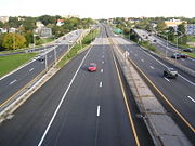
The Cross County Parkway was originally built as an east–west link between the Saw Mill, Bronx River, and Hutchinson River Parkways. Construction began in 1929, and the highway was initially a 40 feet (12.2 m)-wide undivided roadway that could accommodate four lanes of automobile traffic (two in each direction). The parkway had a toll barrier in Fleetwood, which was removed in the early 1950s. The reconstruction of the Cross County Parkway was begun in 1964, and the project was not finally completed until 1984. The parkway is now a multi-lane highway with express and local lanes. In conjunction with the renovation of the Cross County Shopping Center, Exit 5 Westbound and Exit 5 Eastbound of the Cross County Parkway underwent major reconstruction during 2010-2011. The two exit ramps were improved with widening, new traffic lights, and new signage. Traffic can now flow smoothly from the parkway into the shopping center.
Route description
The parkway begins in Yonkers at exit 4 of the Saw Mill River ParkwaySaw Mill River Parkway
The Saw Mill River Parkway is a north–south parkway that extends for through Westchester County, New York, in the United States. It begins at the border between Westchester County and the Bronx, where it continues into New York City as the Henry Hudson Parkway, and heads generally...
. A short distance after, the roadway divides into local and express lanes before forming an intricate interchange with the New York State Thruway
New York State Thruway
The New York State Thruway is a system of limited-access highways located within the state of New York in the United States. The system, known officially as the Governor Thomas E. Dewey Thruway for former New York Governor Thomas E. Dewey, is operated by the New York State Thruway Authority and...
(I-87) and NY 100
New York State Route 100
New York State Route 100 is a major north–south state highway in Westchester County, New York, in the United States. It begins parallel to Interstate 87 at a junction with the Cross County Parkway in the city of Yonkers and runs through most of the length of the county via the city of...
near the Cross County Mall
Cross County Shopping Center
Cross County Shopping Center, also known as Cross County Center is an open-air shopping mall located in Yonkers, New York, United States. Over 100 stores and restaurants are featured in the mall, including anchor stores Macy's, Old Navy and Sears. The mall is managed by Macerich.-History:Cross...
. At exit 6, the Cross County interchanges with the Bronx River Parkway
Bronx River Parkway
The Bronx River Parkway is a long parkway in downstate New York. It is named for the nearby Bronx River, which it parallels. The southern terminus of the parkway is at Story Avenue near Bruckner Expressway in the Bronx neighborhood of Soundview...
near Bronxville
Bronxville, New York
Bronxville is an affluent village within the town of Eastchester, New York, in the United States. It is a suburb of New York City, located approximately north of midtown Manhattan in southern Westchester County. At the 2010 census, Bronxville had a population of 6,323...
, after which the local and express lanes end and merge together. At exit 8, the parkway meets NY 22 as North Columbus Avenue before coming to exit 9, a connector to the southbound Hutchinson River Parkway
Hutchinson River Parkway
The Hutchinson River Parkway is a north–south parkway in southern New York, United States. It extends for from the massive Bruckner Interchange in the Throgs Neck section of the Bronx to the New York – Connecticut state line at Rye Brook...
. The Cross County curves sharply northward to parallel the Hutchinson before merging with the northbound lanes of "The Hutch".
History
Cross County Parkway was originally intended to connect to the Rye Playland ParkwayPlayland Parkway
The Playland Parkway is a , four-lane, divided road in the New York State Parkway System in the United States, and is assigned Westchester County Route 152. The road is restricted to passenger vehicle traffic. The short stretch of road and low-standard freeway connects Interstate 95/New England...
. However this proposal was stalled by the Great Depression
Great Depression
The Great Depression was a severe worldwide economic depression in the decade preceding World War II. The timing of the Great Depression varied across nations, but in most countries it started in about 1929 and lasted until the late 1930s or early 1940s...
and Second World War, and finally cancelled in the 1970s.
Exit list
|-|rowspan=9|Yonkers
Yonkers, New York
Yonkers is the fourth most populous city in the state of New York , and the most populous city in Westchester County, with a population of 195,976...
|
|
|
|Westbound exit and eastbound entrance
|-
|
|1
|Rumsey Road
|Westbound exit only
|-
|0.00
|2
|
|Westbound exit and eastbound entrance
|-
|0.13
|3
|Yonkers Avenue
Yonkers Avenue
Yonkers Avenue is an east–west street in the city of Yonkers in Westchester County, New York, United States. It is one of four major east–west through routes in the city. The western terminus of the street is at Nepperhan Avenue, which connects to U.S. Route 9 and New York State Route 9A...
|
|-
|colspan="4" align="center"|Western terminus of local/express lane division
|-
|1.00
|4S-N
|
|All but exit 4N eastbound is accessible only from local lanes; exit 4N eastbound accessible only from express lanes
|-
|
|5
|Kimball Avenue / Midland Avenue
|Exit accessible only from local lanes
|-
|colspan="4" align="center"|Eastern terminus of local/express lane division (westbound)
|-
|1.78
|6
|
|Eastbound exit accessible only from local lanes; the westbound onramp merges into the local lanes after the split
|-
|rowspan=5|Mount Vernon
Mount Vernon, New York
Mount Vernon is a city in Westchester County, New York, United States. It lies on the border of the New York City borough of The Bronx.-Overview:...
|
|7
|West Broad Street / Gramatan Avenue
|Eastbound exit and entrance; accessible only from local lanes
|-
|colspan="4" align="center"|Eastern terminus of local/express lane division (eastbound)
|-
|2.88
|8
|
|
|-
|3.09
|9
|
|Eastbound exit and westbound entrance
|-
|
|10
|New Rochelle Road
|Eastbound exit and westbound entrance
|-
|Eastchester
|4.46
|
|
|Eastbound exit and westbound entrance