
Interstate 684
Encyclopedia
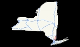
Interstate 684 is a 28.4 mile-long (45.7 km) north–south Interstate Highway in the states of New York
and Connecticut
. The highway connects I-84
with I-287
and the Hutchinson River Parkway
, primarily serving commuter traffic to and from the northern suburbs of the New York metropolitan area
. The route of the highway was originally designated as part of I-87
during the 1960s. A section of the roadway opened to traffic in October 1968. The final segment finished construction in December 1974.
/Harrison
line at exit 9A of the Cross-Westchester Expressway (I-287
). The other, designated as New York State Route 984J (NY 984J) but still signed I-684, begins in Harrison, New York
at exit 26A of the Hutchinson River Parkway
and has one independent exit before joining with the I-287 spur into one route. The route follows a northerly course near the New York/Connecticut
border, passing the Westchester County Airport
, and at one point actually crossing the northwest corner of the Connecticut panhandle
for 1.4 miles (2.3 km) without any exits before returning to New York
. This brief section is maintained by the New York State Department of Transportation
but owned by the Connecticut Department of Transportation
.
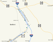
Toward the northern border of Westchester County
, it meets the northern terminus of the Saw Mill River Parkway
. The parkway runs along I-684 for a short distance between its interchange with I-684 and NY 35
, where it ends. During this stretch, the Saw Mill Parkway serves as a collector/distributor road for I-684. Once crossing into Putnam County
, I-684 interchanges with its parent I-84
in Brewster
before making a final interchange at a concurrency of U.S. Route 6 (US 6), US 202, and NY 22
, at which point the route terminates and becomes part of NY 22. The speed limit is 65 mph (105 km/h), except on the spur from the Hutchinson River Parkway
to just north of the I-287
merge, and just south of the I-84
terminus.
 On January 1, 1970, I-87 was relocated to follow the New York State Thruway
north of Elmsford. The old route was redesignated as I-684. Later that year, a third segment of the new highway between Armonk and Bedford Hills opened to traffic as well. The final segment, which proved to be difficult from an engineering standpoint, was completed in December 1974.
!County
!Location
!Mile
!Exit
!Destinations
!Notes
|-
|rowspan=4|Westchester
|rowspan=2|Harrison
|rowspan=2|
|1
|
|Southbound exit and northbound entrance
|-
|
|Manhattanville Road
|
|-
|White Plains
/Harrison
|0.00
|
| / Westchester Avenue
|Southbound exit and northbound entrance
|-
|North Castle
|4.42
|2
|
|Access via Airport Road
|-
|Fairfield
|Greenwich
|colspan=4 align="center"|I-684 enters Connecticut
for 1.4 miles (2.3 km). No exits exist in Connecticut.
|-
|rowspan=7|Westchester
|North Castle
|7.57
|3N-S
|
|Single exit 3 southbound
|-
|rowspan=3|Bedford
|12.64
|4
|
|
|-
|16.75
|5
|
|Southbound exit and northbound entrance
|-
|17.71
|6
|
|
|-
|Lewisboro
|19.90
|6A
|
|Northbound exit and southbound entrance
|-
|rowspan=2|North Salem
|22.36
|7
|
|Northbound exit and southbound entrance
|-
|
|8
|Hardscrabble Road – Croton Falls, Purdys
|
|-
|rowspan=3|Putnam
|rowspan=3|Southeast
|
|9E-W
|
|
|-
|rowspan=2|28.46
|10
|
|
|-
|
|
|Northbound exit and southbound entrance
New York
New York is a state in the Northeastern region of the United States. It is the nation's third most populous state. New York is bordered by New Jersey and Pennsylvania to the south, and by Connecticut, Massachusetts and Vermont to the east...
and Connecticut
Connecticut
Connecticut is a state in the New England region of the northeastern United States. It is bordered by Rhode Island to the east, Massachusetts to the north, and the state of New York to the west and the south .Connecticut is named for the Connecticut River, the major U.S. river that approximately...
. The highway connects I-84
Interstate 84 (east)
Interstate 84 is an Interstate Highway extending from Dunmore, Pennsylvania at an interchange with Interstate 81 to Sturbridge, Massachusetts, at an interchange with the Massachusetts Turnpike . I-84 has mile-log junction numbering in Pennsylvania; otherwise, exit numbers are roughly sequential...
with I-287
Interstate 287
Interstate 287 is an auxiliary Interstate Highway in the U.S. states of New Jersey and New York. It is a partial beltway around New York City, serving the northern half of New Jersey and the counties of Rockland and Westchester in New York...
and the Hutchinson River Parkway
Hutchinson River Parkway
The Hutchinson River Parkway is a north–south parkway in southern New York, United States. It extends for from the massive Bruckner Interchange in the Throgs Neck section of the Bronx to the New York – Connecticut state line at Rye Brook...
, primarily serving commuter traffic to and from the northern suburbs of the New York metropolitan area
New York metropolitan area
The New York metropolitan area, also known as Greater New York, or the Tri-State area, is the region that composes of New York City and the surrounding region...
. The route of the highway was originally designated as part of I-87
Interstate 87
Interstate 87 is a Interstate Highway located entirely within New York State in the United States of America. I-87 is the longest intrastate Interstate highway in the Interstate Highway System. Its southern end is at the Bronx approaches of the Robert F. Kennedy Bridge in New York City...
during the 1960s. A section of the roadway opened to traffic in October 1968. The final segment finished construction in December 1974.
Route description
I-684 begins as two separate spur routes. The primary spur (the one officially designated I-684) begins at the White PlainsWhite Plains, New York
White Plains is a city and the county seat of Westchester County, New York, United States. It is located in south-central Westchester, about east of the Hudson River and northwest of Long Island Sound...
/Harrison
Harrison, New York
Harrison is a village and town in Westchester County, New York, United States, located approximately northeast of Manhattan. The population was 27,472 at the 2010 census.-Establishment:...
line at exit 9A of the Cross-Westchester Expressway (I-287
Interstate 287
Interstate 287 is an auxiliary Interstate Highway in the U.S. states of New Jersey and New York. It is a partial beltway around New York City, serving the northern half of New Jersey and the counties of Rockland and Westchester in New York...
). The other, designated as New York State Route 984J (NY 984J) but still signed I-684, begins in Harrison, New York
Harrison, New York
Harrison is a village and town in Westchester County, New York, United States, located approximately northeast of Manhattan. The population was 27,472 at the 2010 census.-Establishment:...
at exit 26A of the Hutchinson River Parkway
Hutchinson River Parkway
The Hutchinson River Parkway is a north–south parkway in southern New York, United States. It extends for from the massive Bruckner Interchange in the Throgs Neck section of the Bronx to the New York – Connecticut state line at Rye Brook...
and has one independent exit before joining with the I-287 spur into one route. The route follows a northerly course near the New York/Connecticut
Connecticut
Connecticut is a state in the New England region of the northeastern United States. It is bordered by Rhode Island to the east, Massachusetts to the north, and the state of New York to the west and the south .Connecticut is named for the Connecticut River, the major U.S. river that approximately...
border, passing the Westchester County Airport
Westchester County Airport
Westchester County Airport is a county-owned public-use airport in Westchester County, New York, United States. It is located three nautical miles northeast of the central business district of White Plains, in the towns of Harrison, North Castle and Rye Brook.It serves the areas of...
, and at one point actually crossing the northwest corner of the Connecticut panhandle
Connecticut Panhandle
The Connecticut Panhandle, informally known to locals as the Tail, is in southwestern Connecticut, where it abuts New York State. It is contained entirely in Fairfield County and includes all of Greenwich, Stamford, New Canaan, and Darien, as well as part of Norwalk and containing some of the most...
for 1.4 miles (2.3 km) without any exits before returning to New York
New York
New York is a state in the Northeastern region of the United States. It is the nation's third most populous state. New York is bordered by New Jersey and Pennsylvania to the south, and by Connecticut, Massachusetts and Vermont to the east...
. This brief section is maintained by the New York State Department of Transportation
New York State Department of Transportation
The New York State Department of Transportation is responsible for the development and operation of highways, railroads, mass transit systems, ports, waterways and aviation facilities in the U.S...
but owned by the Connecticut Department of Transportation
Connecticut Department of Transportation
The Connecticut Department of Transportation is responsible for the development and operation of highways, railroads, mass transit systems, ports, waterways and aviation facilities in the U.S. state of Connecticut. The current Commissioner of ConnDOT is Jeffrey Parker...
.
Toward the northern border of Westchester County
Westchester County, New York
Westchester County is a county located in the U.S. state of New York. Westchester covers an area of and has a population of 949,113 according to the 2010 Census, residing in 45 municipalities...
, it meets the northern terminus of the Saw Mill River Parkway
Saw Mill River Parkway
The Saw Mill River Parkway is a north–south parkway that extends for through Westchester County, New York, in the United States. It begins at the border between Westchester County and the Bronx, where it continues into New York City as the Henry Hudson Parkway, and heads generally...
. The parkway runs along I-684 for a short distance between its interchange with I-684 and NY 35
New York State Route 35
New York State Route 35 is the principal east–west highway in the northern part of Westchester County, New York, carrying average daily volumes of around 16,500 vehicles...
, where it ends. During this stretch, the Saw Mill Parkway serves as a collector/distributor road for I-684. Once crossing into Putnam County
Putnam County, New York
Putnam County is a county located in the U.S. state of New York, in the lower Hudson River Valley. Putnam county formed in 1812, when it detached from Dutchess County. , the population was 99,710. It is part of the New York Metropolitan Area. The county seat is the hamlet of Carmel...
, I-684 interchanges with its parent I-84
Interstate 84 (east)
Interstate 84 is an Interstate Highway extending from Dunmore, Pennsylvania at an interchange with Interstate 81 to Sturbridge, Massachusetts, at an interchange with the Massachusetts Turnpike . I-84 has mile-log junction numbering in Pennsylvania; otherwise, exit numbers are roughly sequential...
in Brewster
Brewster, New York
Brewster is a village within the town of Southeast in Putnam County, New York, United States. Its population was 2,162 at the 2000 census. The village is the most densely populated portion of the town...
before making a final interchange at a concurrency of U.S. Route 6 (US 6), US 202, and NY 22
New York State Route 22
New York State Route 22 is a north–south state highway in eastern New York in the United States. It runs parallel to the state's eastern edge from the outskirts of New York City to a short distance south of the Canadian border. At , it is the state's longest north–south route and...
, at which point the route terminates and becomes part of NY 22. The speed limit is 65 mph (105 km/h), except on the spur from the Hutchinson River Parkway
Hutchinson River Parkway
The Hutchinson River Parkway is a north–south parkway in southern New York, United States. It extends for from the massive Bruckner Interchange in the Throgs Neck section of the Bronx to the New York – Connecticut state line at Rye Brook...
to just north of the I-287
Interstate 287
Interstate 287 is an auxiliary Interstate Highway in the U.S. states of New Jersey and New York. It is a partial beltway around New York City, serving the northern half of New Jersey and the counties of Rockland and Westchester in New York...
merge, and just south of the I-84
Interstate 84 (east)
Interstate 84 is an Interstate Highway extending from Dunmore, Pennsylvania at an interchange with Interstate 81 to Sturbridge, Massachusetts, at an interchange with the Massachusetts Turnpike . I-84 has mile-log junction numbering in Pennsylvania; otherwise, exit numbers are roughly sequential...
terminus.
History
An expressway along the NY 22 corridor between White Plains and Brewster was planned by Westchester County in 1956. In 1961, the proposed routing of I-87 north of Elmsford along the east bank of the Hudson River was relocated to use the NY 22 corridor instead via modern I-287 and I-84. After much controversy, the routing of I-87 was approved by the Bureau of Public Roads in December 1964. Construction began soon after the approval with the southernmost section between White Plains and Armonk opened in October 1968. The northernmost section between Purdys and Brewster opened in 1969.New York State Thruway
The New York State Thruway is a system of limited-access highways located within the state of New York in the United States. The system, known officially as the Governor Thomas E. Dewey Thruway for former New York Governor Thomas E. Dewey, is operated by the New York State Thruway Authority and...
north of Elmsford. The old route was redesignated as I-684. Later that year, a third segment of the new highway between Armonk and Bedford Hills opened to traffic as well. The final segment, which proved to be difficult from an engineering standpoint, was completed in December 1974.
Exit list
{| class=wikitable!County
!Location
!Mile
!Exit
!Destinations
!Notes
|-
|rowspan=4|Westchester
Westchester County, New York
Westchester County is a county located in the U.S. state of New York. Westchester covers an area of and has a population of 949,113 according to the 2010 Census, residing in 45 municipalities...
|rowspan=2|Harrison
Harrison, New York
Harrison is a village and town in Westchester County, New York, United States, located approximately northeast of Manhattan. The population was 27,472 at the 2010 census.-Establishment:...
|rowspan=2|
|1
|
|Southbound exit and northbound entrance
|-
|
|Manhattanville Road
|
|-
|White Plains
White Plains, New York
White Plains is a city and the county seat of Westchester County, New York, United States. It is located in south-central Westchester, about east of the Hudson River and northwest of Long Island Sound...
/Harrison
Harrison, New York
Harrison is a village and town in Westchester County, New York, United States, located approximately northeast of Manhattan. The population was 27,472 at the 2010 census.-Establishment:...
|0.00
|
| / Westchester Avenue
|Southbound exit and northbound entrance
|-
|North Castle
North Castle, New York
North Castle is a town in Westchester County, New York, United States. The population was 11,841 at the 2010 census. It has no villages.-Geography:...
|4.42
|2
|
|Access via Airport Road
|-
|Fairfield
Fairfield County, Connecticut
Fairfield County is a county located in the southwestern corner of the U.S. state of Connecticut. The county population is 916,829 according to the 2010 Census. There are currently 1,465 people per square mile in the county. It is the most populous county in the State of Connecticut and contains...
|Greenwich
Greenwich, Connecticut
Greenwich is a town in Fairfield County, Connecticut, United States. As of the 2010 census, the town had a total population of 61,171. It is home to many hedge funds and other financial service companies. Greenwich is the southernmost and westernmost municipality in Connecticut and is 38+ minutes ...
|colspan=4 align="center"|I-684 enters Connecticut
Connecticut
Connecticut is a state in the New England region of the northeastern United States. It is bordered by Rhode Island to the east, Massachusetts to the north, and the state of New York to the west and the south .Connecticut is named for the Connecticut River, the major U.S. river that approximately...
for 1.4 miles (2.3 km). No exits exist in Connecticut.
|-
|rowspan=7|Westchester
Westchester County, New York
Westchester County is a county located in the U.S. state of New York. Westchester covers an area of and has a population of 949,113 according to the 2010 Census, residing in 45 municipalities...
|North Castle
North Castle, New York
North Castle is a town in Westchester County, New York, United States. The population was 11,841 at the 2010 census. It has no villages.-Geography:...
|7.57
|3N-S
|
|Single exit 3 southbound
|-
|rowspan=3|Bedford
Bedford (town), New York
Bedford is a town in Westchester County, New York, USA. The population was 17,335 at the 2010 census.The Town of Bedford is located in the northeastern part of Westchester County, and contains the three hamlets of Bedford Hills, Bedford Village, and Katonah...
|12.64
|4
|
|
|-
|16.75
|5
|
|Southbound exit and northbound entrance
|-
|17.71
|6
|
|
|-
|Lewisboro
Lewisboro, New York
Lewisboro is a town in Westchester County, New York, United States. The population was 12,411 at the 2010 census. The town is named after John Lewis.- History :...
|19.90
|6A
|
|Northbound exit and southbound entrance
|-
|rowspan=2|North Salem
North Salem, New York
North Salem is a town in the northeast part of Westchester County, New York, United States. The county ranks second for wealthiest counties in New York State and the seventh wealthiest county nationally...
|22.36
|7
|
|Northbound exit and southbound entrance
|-
|
|8
|Hardscrabble Road – Croton Falls, Purdys
Somers, New York
Somers is a town located in northeastern Westchester County, New York, United States. As of the 2010 census, the town had a population of 20,434...
|
|-
|rowspan=3|Putnam
Putnam County, New York
Putnam County is a county located in the U.S. state of New York, in the lower Hudson River Valley. Putnam county formed in 1812, when it detached from Dutchess County. , the population was 99,710. It is part of the New York Metropolitan Area. The county seat is the hamlet of Carmel...
|rowspan=3|Southeast
Southeast, New York
Southeast is a town in Putnam County, New York, United States. The population was 17,316 at the 2000 census. The town is in the southeast part of the county. Interstate 84, Interstate 684, US Route 202, and US Route 6 pass through the town.- History :...
|
|9E-W
|
|
|-
|rowspan=2|28.46
|10
|
|
|-
|
|
|Northbound exit and southbound entrance