

Yakima County, Washington
Encyclopedia
Yakima County is the second largest county by area in the U.S. state
of Washington. It is named after the Yakama
tribe of Native American
s. In the 2010 census, its population was 243,231. The county seat
is Yakima
, which is also its largest city.
The Yakama Indian Reservation
, the 15th largest reservation in America, covers 1,573 mi² (4,074 km²), comprising 36% of the county's total area. Its population was 31,799 in 2000, and its largest city is Toppenish.
Yakima County was formed out of Ferguson County on January 21, 1865. Ferguson County, no longer in existence, had been created from Walla Walla County on January 23, 1863.
, the county has a total area of 4312 square miles (11,168 km²), of which 4296 square miles (11,126.6 km²) is land and 15 square miles (38.8 km²) (0.36%) is water. Yakima County is the second largest county in Washington by area. Yakima County is also widely known for being one of the most difficult places on earth to predict weather, because of the mountains that surround it. The total area covered by the county is larger than the states of Delaware
and Rhode Island
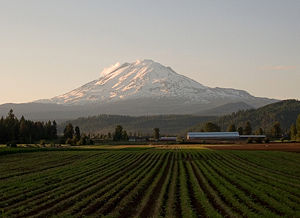
combined. The highest point in the county is Mount Adams, which is the second tallest peak in Washington and the third tallest in the entire Cascade Range.
, behind only California
. The Yakima Valley AVA
was established in 1983 in the state's oldest agricultural region. It is Washington's third largest officially designated American Viticultural Area
(AVA), and is responsible for more than 40% of the state's entire wine production.
Located within the larger Columbia Valley AVA
, the Yakima Valley AVA is sub-divided into the three smaller wine regions, each with its own distinctive growing conditions. They are known as Red Mountain AVA
, Snipes Mountain AVA
, and Rattlesnake Hills AVA
. Of the viticultural region's 665000 acres (269,116.2 ha), nearly 11120 acres (4,500.1 ha) were planted in 2008.
of 2000, there were 222,581 people, 73,993 households, and 54,606 families residing in the county. The population density
was 52 people per square mile (20/km²). There were 79,174 housing units at an average density of 18 per square mile (7/km²). The racial makeup of the county was 65.60% White
, 0.97% Black
or African American
, 4.48% Native American
, 0.95% Asian
, 0.09% Pacific Islander
, 24.43% from other races
, and 3.48% from two or more races. 35.90% of the population were Hispanic
or Latino
of any race. 13.2% were of German, 6.4% United States
or American, 5.9% English
and 5.4% Irish
ancestry according to Census 2000.
There were 73,993 households out of which 39.7% had children under the age of 18 living with them, 55.8% were married couples
living together, 12.5% had a female householder with no husband present, and 26.2% were non-families. 21.5% of all households were made up of individuals and 9.6% had someone living alone who was 65 years of age or older. The average household size was 2.96 and the average family size was 3.44.
In the county, the population was spread out with 31.8% under the age of 18, 9.8% from 18 to 24, 27.5% from 25 to 44, 19.7% from 45 to 64, and 11.2% who were 65 years of age or older. The median age was 31 years. For every 100 females there were 99.6 males. For every 100 females age 18 and over, there were 97.1 males.
The median income for a household in the county was $34,828, and the median income for a family was $39,746. Males had a median income of $31,620 versus $24,541 for females. The per capita income
for the county was $15,606. About 14.8% of families and 19.7% of the population were below the poverty line, including 27.2% of those under age 18 and 11.3% of those age 65 or over.
Sources:
U.S. state
A U.S. state is any one of the 50 federated states of the United States of America that share sovereignty with the federal government. Because of this shared sovereignty, an American is a citizen both of the federal entity and of his or her state of domicile. Four states use the official title of...
of Washington. It is named after the Yakama
Yakama
The Confederated Tribes and Bands of the Yakama Nation, or simply Yakama Nation , is a Native American group with nearly 10,000 enrolled members, living in Washington. Their reservation, along the Yakima River, covers an area of approximately 1.2 million acres...
tribe of Native American
Native Americans in the United States
Native Americans in the United States are the indigenous peoples in North America within the boundaries of the present-day continental United States, parts of Alaska, and the island state of Hawaii. They are composed of numerous, distinct tribes, states, and ethnic groups, many of which survive as...
s. In the 2010 census, its population was 243,231. The county seat
County seat
A county seat is an administrative center, or seat of government, for a county or civil parish. The term is primarily used in the United States....
is Yakima
Yakima, Washington
Yakima is an American city southeast of Mount Rainier National Park and the county seat of Yakima County, Washington, United States, and the eighth largest city by population in the state itself. As of the 2010 census, the city had a total population of 91,196 and a metropolitan population of...
, which is also its largest city.
The Yakama Indian Reservation
Yakama Indian Reservation
The Yakama Indian Reservation is a United States Indian reservation located on the east side of the Cascade Mountains in southern Washington. It is the homeland of the Yakama tribe of Native Americans....
, the 15th largest reservation in America, covers 1,573 mi² (4,074 km²), comprising 36% of the county's total area. Its population was 31,799 in 2000, and its largest city is Toppenish.
Yakima County was formed out of Ferguson County on January 21, 1865. Ferguson County, no longer in existence, had been created from Walla Walla County on January 23, 1863.
Geography
According to the U.S. Census BureauUnited States Census Bureau
The United States Census Bureau is the government agency that is responsible for the United States Census. It also gathers other national demographic and economic data...
, the county has a total area of 4312 square miles (11,168 km²), of which 4296 square miles (11,126.6 km²) is land and 15 square miles (38.8 km²) (0.36%) is water. Yakima County is the second largest county in Washington by area. Yakima County is also widely known for being one of the most difficult places on earth to predict weather, because of the mountains that surround it. The total area covered by the county is larger than the states of Delaware
Delaware
Delaware is a U.S. state located on the Atlantic Coast in the Mid-Atlantic region of the United States. It is bordered to the south and west by Maryland, and to the north by Pennsylvania...
and Rhode Island
Rhode Island
The state of Rhode Island and Providence Plantations, more commonly referred to as Rhode Island , is a state in the New England region of the United States. It is the smallest U.S. state by area...
combined. The highest point in the county is Mount Adams, which is the second tallest peak in Washington and the third tallest in the entire Cascade Range.
Geographic features
- Mount AdamsMount Adams (Washington)Mount Adams is a potentially activestratovolcano in the Cascade Range and the second-highest mountain in the U.S. state of Washington.Adams is a member of the Cascade Volcanic Arc, and is one of the arc's largest volcanoes,...
, 12281 feet (3,743 m) - Gilbert Peak, 8184 feet (2,494 m)
- Mount Aix, 7766 feet (2,367 m)
- Tieton Peak, 7724 feet (2,354 m)
- Cascade MountainsCascade RangeThe Cascade Range is a major mountain range of western North America, extending from southern British Columbia through Washington and Oregon to Northern California. It includes both non-volcanic mountains, such as the North Cascades, and the notable volcanoes known as the High Cascades...
- Rattlesnake HillsRattlesnake HillsThe Rattlesnake Hills is a 16 mile long anticline mountain ridge in Yakima County and Benton County in the U.S. state of Washington. Also known as Rattlesnake Mountain and Rattlesnake Ridge, it should not be confused with the much smaller Rattlesnake Ridge located near the west end of Ahtanum Ridge...
- Horse Heaven HillsHorse Heaven HillsThe Horse Heaven Hills are a long range of high, rolling hills in Klickitat, Yakima, and Benton counties in Washington State located east of Satus Creek and west of the Columbia River between the Yakima River and the Wallula Gap. The hills are an anticline ridge in the Yakima fold belt formed by...
Major rivers
- Yakima RiverYakima RiverThe Yakima River is a tributary of the Columbia River in south central and eastern Washington State, named for the indigenous Yakama people. The length of the river from headwaters to mouth is , with an average drop of .-Course:...
- Columbia RiverColumbia RiverThe Columbia River is the largest river in the Pacific Northwest region of North America. The river rises in the Rocky Mountains of British Columbia, Canada, flows northwest and then south into the U.S. state of Washington, then turns west to form most of the border between Washington and the state...
- Naches RiverNaches RiverThe Naches River is a tributary of the Yakima River in central Washington in the United States. Beginning as the Little Naches River, it is about 75 miles long. After the confluence of the Little Naches and Bumping River the name becomes simply the Naches River...
- Tieton RiverTieton RiverThe Tieton River is a tributary of the Naches River, in Yakima County, Washington in the United States.The Tieton River begins in two forks, the North Fork Tieton River and South Fork Tieton River. The North Fork originates at McCall Glacier on the eastern sides of Old Snowy Mountain, Ives Peak,...
- Bumping RiverBumping RiverThe Bumping River is a tributary of the Naches River, in Washington in the United States. It flows down the east side of the Cascade Range, through Wenatchee National Forest and the William O. Douglas Wilderness. From its source at Fish Lake near Crag Mountain, it flows northeast to Bumping Lake, a...
- American RiverAmerican River (Washington)The American River is a tributary of the Bumping River, in Washington in the United States. It flows down the east side of the Cascade Range, through Wenatchee National Forest and the William O...
National protected areas
- Wenatchee National ForestWenatchee National ForestWenatchee National Forest is a U.S. National Forest located in Washington. With an area of 1,735,394 acres , it extends about 137 miles along the eastern slopes of the Cascade Range of Washington, USA from Okanogan National Forest to Gifford Pinchot National Forest...
(part) - Gifford Pinchot National ForestGifford Pinchot National ForestGifford Pinchot National Forest is a U.S. National Forest located in southern Washington, USA. With an area of 1.37 million acres , it extends 116 km along the western slopes of Cascade Range from Mount Rainier National Park to the Columbia River. It includes the 110,000 acre Mount St....
(part) - Snoqualmie National ForestSnoqualmie National ForestSnoqualmie National Forest is a United States National Forest in the State of Washington. It was established on 1 July 1908, when an area of 961,120 acres was split from the existing Washington National Forest. Its size was increased on 13 October 1933, when a part of Rainier National Forest was...
(part)
- Goat Rocks WildernessGoat Rocks WildernessGoat Rocks Wilderness is a U.S. Wilderness Area in Washington, United States. Consisting of portions of Mount Baker-Snoqualmie National Forest and Gifford Pinchot National Forest on the crest of the Cascade Range south of U.S...
- Mount Adams WildernessMount Adams WildernessThe Mount Adams Wilderness has of ecologically complex and geologically active land. Weather differs between the dry eastside and moist westside of the mountain. At , Mount Adams is one of the major Cascade mountains. The wilderness area is on the west side of the mountain and is part of the...
(part) - Norse Peak WildernessNorse Peak WildernessNorse Peak Wilderness is located in central Washington in the United States. It protects the portion of the Cascade Range north of Chinook Pass , south of Naches Pass , and east of Mt. Rainier National Park. This 50,923 acre wilderness is named for a prominent peak which overlooks Crystal Mountain...
(part) - William O. Douglas WildernessWilliam O. Douglas WildernessThe William O. Douglas Wilderness is a designated wilderness located in central portion of the U.S. state of Washington. It includes 168,232 acres located between the U.S. Route 12 and State Route 410 and is jointly administered by the Snoqualmie National Forest and the Gifford Pinchot National...
- Toppenish National Wildlife RefugeToppenish National Wildlife RefugeToppenish National Wildlife Refuge is located in the agriculturally intensive Yakima Valley of eastern Washington. Using the waters of Toppenish and Snake Creeks and supplemented with summer irrigation, managers are able to provide a mosaic of refuge wetlands interspersed with lush riparian and...
Major roads
 Interstate 82Interstate 82Interstate 82 is a Interstate Highway that extends from I-90 in Ellensburg, Washington to I-84 near Umatilla, Oregon in the United States. In the state of Washington, it serves the cities of Ellensburg, Yakima, and the Tri Cities , and in Oregon, it serves Umatilla and Hermiston...
 U.S. Route 12U.S. Route 12 in WashingtonU.S. Route 12 is a major east-west U.S. Highway, running from Aberdeen, Washington, to Detroit, Michigan. It spans across the state of Washington, and is the only numbered highway to span the entire state from west to east, starting near the Pacific Ocean, and crossing the Idaho state line near...
 U.S. Route 97U.S. Route 97 in WashingtonIn the U.S. state of Washington, U.S. Route 97 is a route which traverses from the Oregon state line at the northern end of the Sam Hill Memorial Bridge in Maryhill, north to the Canadian border in Okanogan County near Oroville...
Adjacent counties
- Pierce County, WashingtonPierce County, Washingtonright|thumb|[[Tacoma, Washington|Tacoma]] - Seat of Pierce CountyPierce County is the second most populous county in the U.S. state of Washington. Formed out of Thurston County on December 22, 1852, by the legislature of Oregon Territory...
- northwest - Lewis County, WashingtonLewis County, WashingtonLewis County is a county located in the U.S. state of Washington. As of 2010, the population was 75,455. The county seat is at Chehalis, and its largest city is Centralia....
- west - Skamania County, Washington - southwest
- Kittitas County, Washington - north
- Klickitat County, Washington - south
- Grant County, Washington - northeast
- Benton County, WashingtonBenton County, WashingtonBenton County is a county located in the south-central portion of the U.S. state of Washington. The Columbia River makes up the north, south, and east boundaries of the county. In 2010, its population was 175,177. The county seat is Prosser, and its largest city is Kennewick...
- east
Wines regions
Washington ranks second in the United States in the production of wineWine
Wine is an alcoholic beverage, made of fermented fruit juice, usually from grapes. The natural chemical balance of grapes lets them ferment without the addition of sugars, acids, enzymes, or other nutrients. Grape wine is produced by fermenting crushed grapes using various types of yeast. Yeast...
, behind only California
California wine
California wine has a long and continuing history, and in the late twentieth century became recognized as producing some of the world's finest wine. While wine is made in all fifty U.S. states, up to 90% of American wine is produced in the state...
. The Yakima Valley AVA
Yakima Valley AVA
The Yakima Valley AVA was the first American Viticultural Area established within Washington State, gaining the recognition in 1983. Part of the larger Columbia Valley AVA, Yakima Valley AVA is home to more than of vineyards, giving the area the largest concentration of wineries and vineyards in...
was established in 1983 in the state's oldest agricultural region. It is Washington's third largest officially designated American Viticultural Area
American Viticultural Area
An American Viticultural Area is a designated wine grape-growing region in the United States distinguishable by geographic features, with boundaries defined by the Alcohol and Tobacco Tax and Trade Bureau , United States Department of the Treasury....
(AVA), and is responsible for more than 40% of the state's entire wine production.
Located within the larger Columbia Valley AVA
Columbia Valley AVA
The Columbia Valley AVA is an American Viticultural Area which lies in the Columbia River Plateau, through much of central and southern Washington state, with a small section crossing into the neighboring state of Oregon. The AVA includes the drainage basin of the Columbia River and its tributaries...
, the Yakima Valley AVA is sub-divided into the three smaller wine regions, each with its own distinctive growing conditions. They are known as Red Mountain AVA
Red Mountain AVA
The Red Mountain AVA is an American Viticultural Area that includes the land surrounding Red Mountain in Benton County, Washington. It is part of the Yakima Valley AVA, which in turn is part of the larger Columbia Valley AVA. Located between Benton City and Richland, the Red Mountain AVA is the...
, Snipes Mountain AVA
Snipes Mountain AVA
Snipes Mountain AVA is an American Viticultural Area located in the Yakima Valley of Washington State. It was approved by the Bureau of Alcohol, Tobacco, Firearms and Explosives on January 21, 2009 making it Washington's 10th federally-designated AVA. It is the second smallest AVA in the state,...
, and Rattlesnake Hills AVA
Rattlesnake Hills AVA
The Rattlesnake Hills AVA is an American Viticultural Area located in Yakima County, Washington. United States Alcohol and Tobacco Tax and Trade Bureau awarded Rattlesnake Hills its appellation status on March 20, 2006, making Rattlesnake Hills Washington’s ninth federally recognized American...
. Of the viticultural region's 665000 acres (269,116.2 ha), nearly 11120 acres (4,500.1 ha) were planted in 2008.
Demographics
As of the censusCensus
A census is the procedure of systematically acquiring and recording information about the members of a given population. It is a regularly occurring and official count of a particular population. The term is used mostly in connection with national population and housing censuses; other common...
of 2000, there were 222,581 people, 73,993 households, and 54,606 families residing in the county. The population density
Population density
Population density is a measurement of population per unit area or unit volume. It is frequently applied to living organisms, and particularly to humans...
was 52 people per square mile (20/km²). There were 79,174 housing units at an average density of 18 per square mile (7/km²). The racial makeup of the county was 65.60% White
Race (United States Census)
Race and ethnicity in the United States Census, as defined by the Federal Office of Management and Budget and the United States Census Bureau, are self-identification data items in which residents choose the race or races with which they most closely identify, and indicate whether or not they are...
, 0.97% Black
Race (United States Census)
Race and ethnicity in the United States Census, as defined by the Federal Office of Management and Budget and the United States Census Bureau, are self-identification data items in which residents choose the race or races with which they most closely identify, and indicate whether or not they are...
or African American
Race (United States Census)
Race and ethnicity in the United States Census, as defined by the Federal Office of Management and Budget and the United States Census Bureau, are self-identification data items in which residents choose the race or races with which they most closely identify, and indicate whether or not they are...
, 4.48% Native American
Race (United States Census)
Race and ethnicity in the United States Census, as defined by the Federal Office of Management and Budget and the United States Census Bureau, are self-identification data items in which residents choose the race or races with which they most closely identify, and indicate whether or not they are...
, 0.95% Asian
Race (United States Census)
Race and ethnicity in the United States Census, as defined by the Federal Office of Management and Budget and the United States Census Bureau, are self-identification data items in which residents choose the race or races with which they most closely identify, and indicate whether or not they are...
, 0.09% Pacific Islander
Race (United States Census)
Race and ethnicity in the United States Census, as defined by the Federal Office of Management and Budget and the United States Census Bureau, are self-identification data items in which residents choose the race or races with which they most closely identify, and indicate whether or not they are...
, 24.43% from other races
Race (United States Census)
Race and ethnicity in the United States Census, as defined by the Federal Office of Management and Budget and the United States Census Bureau, are self-identification data items in which residents choose the race or races with which they most closely identify, and indicate whether or not they are...
, and 3.48% from two or more races. 35.90% of the population were Hispanic
Race (United States Census)
Race and ethnicity in the United States Census, as defined by the Federal Office of Management and Budget and the United States Census Bureau, are self-identification data items in which residents choose the race or races with which they most closely identify, and indicate whether or not they are...
or Latino
Race (United States Census)
Race and ethnicity in the United States Census, as defined by the Federal Office of Management and Budget and the United States Census Bureau, are self-identification data items in which residents choose the race or races with which they most closely identify, and indicate whether or not they are...
of any race. 13.2% were of German, 6.4% United States
United States
The United States of America is a federal constitutional republic comprising fifty states and a federal district...
or American, 5.9% English
English people
The English are a nation and ethnic group native to England, who speak English. The English identity is of early mediaeval origin, when they were known in Old English as the Anglecynn. England is now a country of the United Kingdom, and the majority of English people in England are British Citizens...
and 5.4% Irish
Irish American
Irish Americans are citizens of the United States who can trace their ancestry to Ireland. A total of 36,278,332 Americans—estimated at 11.9% of the total population—reported Irish ancestry in the 2008 American Community Survey conducted by the U.S. Census Bureau...
ancestry according to Census 2000.
There were 73,993 households out of which 39.7% had children under the age of 18 living with them, 55.8% were married couples
Marriage
Marriage is a social union or legal contract between people that creates kinship. It is an institution in which interpersonal relationships, usually intimate and sexual, are acknowledged in a variety of ways, depending on the culture or subculture in which it is found...
living together, 12.5% had a female householder with no husband present, and 26.2% were non-families. 21.5% of all households were made up of individuals and 9.6% had someone living alone who was 65 years of age or older. The average household size was 2.96 and the average family size was 3.44.
In the county, the population was spread out with 31.8% under the age of 18, 9.8% from 18 to 24, 27.5% from 25 to 44, 19.7% from 45 to 64, and 11.2% who were 65 years of age or older. The median age was 31 years. For every 100 females there were 99.6 males. For every 100 females age 18 and over, there were 97.1 males.
The median income for a household in the county was $34,828, and the median income for a family was $39,746. Males had a median income of $31,620 versus $24,541 for females. The per capita income
Per capita income
Per capita income or income per person is a measure of mean income within an economic aggregate, such as a country or city. It is calculated by taking a measure of all sources of income in the aggregate and dividing it by the total population...
for the county was $15,606. About 14.8% of families and 19.7% of the population were below the poverty line, including 27.2% of those under age 18 and 11.3% of those age 65 or over.
Census-recognized communities
- AhtanumAhtanum, WashingtonAhtanum is a census-designated place in Yakima County, Washington, United States. The population was 3,601 at the 2010 census.-Geography:Ahtanum is located at ....
- EschbachEschbach, WashingtonEschbach is a census-designated place in Yakima County, Washington, United States. The population was 415 at the 2010 census.-Geography:Eschbach is located at ....
- GleedGleed, WashingtonGleed is a census-designated place in Yakima County, Washington, United States. The population was 2,906 at the 2010 census.-Geography:Gleed is located at ....
- GrandviewGrandview, WashingtonGrandview is a city in Yakima County, Washington, United States. The population was 8,377 at the 2000 census.-History:Grandview received its name in 1906 due to its view of Mount Rainier and Mount Adams. Grandview was officially incorporated on September 21, 1909...
- GrangerGranger, WashingtonGranger is a city in Yakima County, Washington, United States. The population was 3,246 at the 2010 census. Although it was classified as a town in 2000, it has since been reclassified as a city.-History:...
- HarrahHarrah, WashingtonHarrah is a town in Yakima County, Washington, United States. The population was 630 at the 2010 census.-History:Harrah was officially incorporated on January 23, 1946...
- MabtonMabton, WashingtonMabton is a city in Yakima County, Washington, United States. The population was 2,286 at the 2010 census. Incorporated during the first few years of the 20th century, it is located at the eastern edge of the Yakama Indian Reservation.-History:...
- MoxeeMoxee, WashingtonMoxee is a city in Yakima County, Washington, United States. The population was 3,308 at the 2010 census.According to the Washington State Office of Financial Management, Moxee ranked 5th of 279 eligible incorporated communities in population growth between 2000 and 2005.-History:Moxee was first...
- NachesNaches, WashingtonNaches is a town in Yakima County, Washington, United States. The population was 795 individuals at the 2010 census.-Infrastructure:Naches' infrastructure is based mainly on timber and agriculture, known for its large masses of apple, cherries, pears and various other fruits.-Geography:Naches is...
- SatusSatus, WashingtonSatus is a census-designated place in Yakima County, Washington, United States. The population was 746 at the 2000 census. The community was not recognized in the 2010 census.-Geography:Satus is located at ....
- SelahSelah, WashingtonSelah is a city in Yakima County, Washington, United States. The population was 7,147 at the 2010 census.-History:Selah was officially incorporated on April 3, 1919. The government is a Strong Mayor/Council form. The Tree Top apple processor co-operative has its headquarters and two processing...
- SummitviewSummitview, WashingtonSummitview is a census-designated place in Yakima County, Washington, United States. The population was 967 at the 2010 census.Based on per capita income, Summitview ranks 18th of 522 areas in the state of Washington to be ranked...
- SunnysideSunnyside, WashingtonSunnyside is a city in Yakima County, Washington, United States. As of the 2010 Census the population was 15,858.-History:On September 16, 1902, residents voted 42 to one to incorporate as the town of Sunnyside. By state law a town needed to have 300 citizens in order to legally incorporate...
- Terrace HeightsTerrace Heights, WashingtonTerrace Heights is a census-designated place in Yakima County, Washington, United States. The population was 6,937 at the 2010 census. It is essentially a suburb of the city of Yakima.-Geography:Terrace Heights is located at ....
- TietonTieton, WashingtonTieton is a town in Yakima County, Washington, United States. The population was 1,191 at the 2010 census.In recent years, Tieton has suffered economic depression, with the decline of its fruit warehouses...
- ToppenishToppenish, WashingtonToppenish is a city in Yakima County, Washington, in the United States. As of the 2010 census, the city population was 8,949.-History:The General Allotment Act of 1887 granted an allotment of land to a woman of half Indian ancestry, Josephine Bowser Lillie, known as "The Mother of Toppenish"...
- Union GapUnion Gap, WashingtonUnion Gap is a city in Yakima County, Washington, in the United States. As of the 2010 census, the city population was 6,047.-History:The city of Union Gap was originally named Yakima and was officially incorporated on November 23, 1883...
- WapatoWapato, WashingtonWapato is a city in Yakima County, Washington, United States. The population was 4,997 at the 2010 census.-History:The town was originally founded in 1885 by Indian Postmaster Alexander McCredy as a railroad stop on the Northern Pacific Railroad as Simcoe, Washington...
- White SwanWhite Swan, WashingtonWhite Swan is a census-designated place in Yakima County, Washington, United States. The population was 793 at the 2010 census. This was a 73.9% drop from the 2000 census.-History:...
- YakimaYakima, WashingtonYakima is an American city southeast of Mount Rainier National Park and the county seat of Yakima County, Washington, United States, and the eighth largest city by population in the state itself. As of the 2010 census, the city had a total population of 91,196 and a metropolitan population of...
- ZillahZillah, WashingtonZillah is a city in Yakima County, Washington, United States with a population of 2,964 at the 2010 census.-History:Zillah was founded in 1891 following the completion of the Sunnyside Canal project, an irrigation scheme delivering water from the Yakima River to the arid lower Yakima Valley. Walter...
Other communities
- Birchfield 46°34′37"N 120°26′04"W
- BrownstownBrownstown, WashingtonBrownstown is an unincorporated community in Yakima County, Washington, United States. Brownstown is west of Harrah. Brownstown has a post office with ZIP code 98920....
46°24′15"N 120°36′25"W - BuenaBuena, WashingtonBuena is an unincorporated community in Yakima County, with a 2010 cenus population of 990. The community was not recognized in the 2000 census figures. Washington, United States. Buena is north of Toppenish. Buena has a post office with ZIP code 98921....
46°25′43"N 120°18′48"W - Byron 46°11′16"N 119°52′28"W
- Cliffdell 46°56′46"N 121°04′08"W
- Cougar Valley 47°01′10"N 120°21′29"W
- Cowiche 46°40′11"N 120°42′44"W
- Donald 46°28′35"N 120°23′48"W
- East Selah 46°39′52"N 120°29′16"W
- Fruitvale 46°37′04"N 120°33′11"W
- Goose PrairieGoose Prairie, WashingtonGoose Prairie is an unincorporated community in Yakima County, Washington, United States. Goose Prairie is northwest of Yakima. Goose Prairie has a post office with ZIP code 98929...
46°53′42"N 121°16′01"W - Harwood 46°34′56"N 120°39′22"W
- Nile 46°49′14"N 120°52′22"W
- OutlookOutlook, WashingtonOutlook is an unincorporated community in Yakima County, Washington, United States. Outlook is located along Interstate 82 and U.S. Route 12 west of Sunnyside. Outlook has a post office with ZIP code 98938....
46°19′52"N 120°05′28"W
- ParkerParker, WashingtonParker is an unincorporated small town in central Yakima County, Washington. It is located on U.S. Route 97 between the cities of Yakima and Wapato on the Yakama Indian Reservation. The town had a population of 154 at the 2010 census.-History:...
46°30′03"N 120°27′55"W - Pinecliff 46°53′57"N 121°00′47"W
- Pomona 46°41′25"N 120°29′14"W
- Rimrock 46°39′51"N 121°07′30"W
- Sawyer 46°27′23"N 120°21′41"W
- Tampico 46°32′06"N 120°52′02"W
- Weikel 46°37′57"N 120°40′02"W
Historical communities
- Alfalfa 46°19′29"N 120°12′20"W
- Artesian 46°33′07"N 120°21′16"W
- Ashue 46°24′15"N 120°27′34"W
- Belma 46°14′38"N 119°58′44"W
- Black Rock 46°30′41"N 119°59′52"W
- Emerald 46°18′09"N 120°04′53"W
- Empire 46°13′54"N 120°04′24"W
- Farron 46°26′16"N 120°31′17"W
- Flint 46°26′46"N 120°20′43"W
- Fort Simcoe 46°20′33"N 120°50′22"W
- Givens Corner 46°15′03"N 119°59′57"W
- Gromore 46°35′18"N 120°41′53"W
- Holtzinger 46°40′39"N 120°43′14"W
- Jonathan 46°25′43"N 120°18′48"W
- Liberty 46°21′20"N 120°08′46"W
- Lichty 46°17′33"N 119°57′11"W
- Midvale 46°17′03"N 120°00′52"W
- Nass 46°20′19"N 120°08′46"W
- Plainview 46°04′37"N 120°01′14"W
- Spitzenberg 46°36′53"N 120°36′15"W
- Venner 46°24′17"N 120°30′07"W
- Waneta 46°16′49"N 119°58′04"W
- Wenas 46°52′21"N 120°46′26"W
- Wiley City 46°33′05"N 120°38′57"W
- Yethonat 46°24′16"N 120°23′47"W
Sources: