
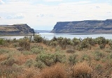
Wallula, Washington
Encyclopedia
Wallula is a census-designated place
(CDP) in Walla Walla County, Washington, United States. The population was 179 at the 2010 census.
reached the area April 27, 1806, on their return journey from the Pacific. The expedition spent three days at the village of Chief Yallept and his tribe of Walla Wallas (relatives of the Nez Perce), in the company of about a hundred Yakama
s. Lewis
put the total people at around 550. There the expedition learned of an overland route to the Nez Perce homelands which shortened their route by some eighty miles.
During David Thompson
's 1811 voyage down the Columbia River he camped at the junction with the Snake River
on July 9, 1811, and erected a pole and a notice claiming the country for Great Britain and stating the intention of the North West Company to build a trading post at the site.
Western Settlement of the area began in 1818, when the North West Company
built Fort Nez Perce at the mouth of the Walla Walla River
. The location was chosen to compete with the Hudson's Bay Company
for the fur trade in the Pacific Northwest. That site was maintained until 1855.
The first railroad to connect Walla Walla
with the Columbia River
at Wallula was begun in 1871. The 30-mile line, called the Walla Walla and Columbia River Railroad, was completed October 23, 1875. The line would later become a part of the Northern Pacific Railroad. To save money, the original rails were wooden with strap iron on the upper surface.
In 1883, the Northern Pacific completed its line from St. Paul, Minnesota, to present-day Wallula, Washington, where it connected to the Oregon Railway and Navigation Company tracks down the south side of the Columbia River.
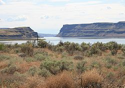 Wallula is located at 46°5′4"N 118°54′23"W (46.084446, -118.906256).
According to the United States Census Bureau
, the CDP has a total area of 0.1 square mile (0.3 km²), all land.
. Hispanic or Latino of any race were 16.75% of the population.
There were 60 households out of which 45.0% had children under the age of 18 living with them, 61.7% were married couples living together, 11.7% had a female householder with no husband present, and 20.0% were non-families. 8.3% of all households were made up of individuals and 1.7% had someone living alone who was 65 years of age or older. The average household size was 3.28 and the average family size was 3.38.
In the CDP the age distribution of the population shows 39.6% under the age of 18, 2.5% from 18 to 24, 26.9% from 25 to 44, 20.8% from 45 to 64, and 10.2% who were 65 years of age or older. The median age was 32 years. For every 100 females there were 91.3 males. For every 100 females age 18 and over, there were 83.1 males.
The median income for a household in the CDP was $26,071, and the median income for a family was $26,071. Males had a median income of $26,000 versus $18,611 for females. The per capita income
for the CDP was $10,831. About 7.4% of families and 11.7% of the population were below the poverty line, including 18.7% of those under the age of eighteen and none of those sixty five or over.
Census-designated place
A census-designated place is a concentration of population identified by the United States Census Bureau for statistical purposes. CDPs are delineated for each decennial census as the statistical counterparts of incorporated places such as cities, towns and villages...
(CDP) in Walla Walla County, Washington, United States. The population was 179 at the 2010 census.
History
Lewis and ClarkLewis and Clark Expedition
The Lewis and Clark Expedition, or ″Corps of Discovery Expedition" was the first transcontinental expedition to the Pacific Coast by the United States. Commissioned by President Thomas Jefferson and led by two Virginia-born veterans of Indian wars in the Ohio Valley, Meriwether Lewis and William...
reached the area April 27, 1806, on their return journey from the Pacific. The expedition spent three days at the village of Chief Yallept and his tribe of Walla Wallas (relatives of the Nez Perce), in the company of about a hundred Yakama
Yakama
The Confederated Tribes and Bands of the Yakama Nation, or simply Yakama Nation , is a Native American group with nearly 10,000 enrolled members, living in Washington. Their reservation, along the Yakima River, covers an area of approximately 1.2 million acres...
s. Lewis
Meriwether Lewis
Meriwether Lewis was an American explorer, soldier, and public administrator, best known for his role as the leader of the Lewis and Clark Expedition also known as the Corps of Discovery, with William Clark...
put the total people at around 550. There the expedition learned of an overland route to the Nez Perce homelands which shortened their route by some eighty miles.
During David Thompson
David Thompson (explorer)
David Thompson was an English-Canadian fur trader, surveyor, and map-maker, known to some native peoples as "Koo-Koo-Sint" or "the Stargazer"...
's 1811 voyage down the Columbia River he camped at the junction with the Snake River
Snake River
The Snake is a major river of the greater Pacific Northwest in the United States. At long, it is the largest tributary of the Columbia River, the largest North American river that empties into the Pacific Ocean...
on July 9, 1811, and erected a pole and a notice claiming the country for Great Britain and stating the intention of the North West Company to build a trading post at the site.
Western Settlement of the area began in 1818, when the North West Company
North West Company
The North West Company was a fur trading business headquartered in Montreal from 1779 to 1821. It competed with increasing success against the Hudson's Bay Company in what was to become Western Canada...
built Fort Nez Perce at the mouth of the Walla Walla River
Walla Walla River
The Walla Walla River is a tributary of the Columbia River, joining the Columbia just above Wallula Gap in southeastern Washington in the United States. The river flows through Umatilla County, Oregon and Walla Walla County, Washington. Its drainage basin is in area.-Course:The headwaters of the...
. The location was chosen to compete with the Hudson's Bay Company
Hudson's Bay Company
The Hudson's Bay Company , abbreviated HBC, or "The Bay" is the oldest commercial corporation in North America and one of the oldest in the world. A fur trading business for much of its existence, today Hudson's Bay Company owns and operates retail stores throughout Canada...
for the fur trade in the Pacific Northwest. That site was maintained until 1855.
The first railroad to connect Walla Walla
Walla Walla, Washington
Walla Walla is the largest city in and the county seat of Walla Walla County, Washington, United States. The population was 31,731 at the 2010 census...
with the Columbia River
Columbia River
The Columbia River is the largest river in the Pacific Northwest region of North America. The river rises in the Rocky Mountains of British Columbia, Canada, flows northwest and then south into the U.S. state of Washington, then turns west to form most of the border between Washington and the state...
at Wallula was begun in 1871. The 30-mile line, called the Walla Walla and Columbia River Railroad, was completed October 23, 1875. The line would later become a part of the Northern Pacific Railroad. To save money, the original rails were wooden with strap iron on the upper surface.
In 1883, the Northern Pacific completed its line from St. Paul, Minnesota, to present-day Wallula, Washington, where it connected to the Oregon Railway and Navigation Company tracks down the south side of the Columbia River.
Geography
According to the United States Census Bureau
United States Census Bureau
The United States Census Bureau is the government agency that is responsible for the United States Census. It also gathers other national demographic and economic data...
, the CDP has a total area of 0.1 square mile (0.3 km²), all land.
Demographics
As of the census of 2000, there were 197 people, 60 households, and 48 families residing in the CDP. The population density was 1,978.5 people per square mile (760.6/km²). There were 64 housing units at an average density of 642.8/sq mi (247.1/km²). The racial makeup of the CDP was 87.31% White, 1.02% Native American, 11.68% from other racesRace (United States Census)
Race and ethnicity in the United States Census, as defined by the Federal Office of Management and Budget and the United States Census Bureau, are self-identification data items in which residents choose the race or races with which they most closely identify, and indicate whether or not they are...
. Hispanic or Latino of any race were 16.75% of the population.
There were 60 households out of which 45.0% had children under the age of 18 living with them, 61.7% were married couples living together, 11.7% had a female householder with no husband present, and 20.0% were non-families. 8.3% of all households were made up of individuals and 1.7% had someone living alone who was 65 years of age or older. The average household size was 3.28 and the average family size was 3.38.
In the CDP the age distribution of the population shows 39.6% under the age of 18, 2.5% from 18 to 24, 26.9% from 25 to 44, 20.8% from 45 to 64, and 10.2% who were 65 years of age or older. The median age was 32 years. For every 100 females there were 91.3 males. For every 100 females age 18 and over, there were 83.1 males.
The median income for a household in the CDP was $26,071, and the median income for a family was $26,071. Males had a median income of $26,000 versus $18,611 for females. The per capita income
Per capita income
Per capita income or income per person is a measure of mean income within an economic aggregate, such as a country or city. It is calculated by taking a measure of all sources of income in the aggregate and dividing it by the total population...
for the CDP was $10,831. About 7.4% of families and 11.7% of the population were below the poverty line, including 18.7% of those under the age of eighteen and none of those sixty five or over.