
Interstate 70 in Utah
Encyclopedia
Interstate 70 is a mainline route of the Interstate Highway System
in the United States
connecting Utah
and Maryland
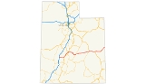
. The Utah section runs east–west for 232.15 miles (373.61 km) across the central part of the state. Richfield
is the largest Utah city served by the freeway, which does not serve or connect any urban areas in the state. The freeway was built as part of a system of highways connecting Los Angeles
and the northeastern United States
. I-70 was the second attempt to connect southern California to the east coast
of the United States via central Utah, the first being a failed attempt to construct a transcontinental railroad
. Parts of that effort were re-used in the laying out of the route of I-70.
Unlike most Interstate Highways, I-70 in Utah was not constructed parallel to or on top of an existing U.S. Highway. Portions of I-70 were constructed in areas where previously there were no paved roads. Because it was built over an entirely new route, I-70 has many features that are unique in the Interstate Highway System
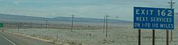
. For example, the 110 miles (177 km) between Green River
and Salina
makes up the longest distance anywhere in the Interstate Highway System with no motorist services. This same piece is noted as the longest highway in the United States built over a completely new route since the Alaska Highway
, and the longest piece of Interstate Highway to open at a given time. The construction of the Utah portion of I-70 is listed as one of the engineering marvels of the Interstate Highway System.
The choice of the route had a significant impact on the character and culture of the Sevier Valley
. It has also been a motivating factor for environmentalists to create a new National Park
along the path of the highway to protect scenic areas around the route. I-70 from Green River to Grand Junction, Colorado
is part of the Dinosaur Diamond Prehistoric Highway, making I-70 one of the few Interstate Highways to be named a National Scenic Byway
. Attractions listed by the Federal Highway Administration
for the Dinosaur Diamond Prehistoric Highway on or near I-70 include, Arches National Park
, Canyonlands National Park
, Cleveland-Lloyd Dinosaur Quarry, Goblin Valley State Park
and Westwater
. The designation lists several side roads branching from I-70 that lead to dinosaur bones or footprints.
. It then proceeds east over the Pavant Range
, cresting at an unnamed summit
with an elevation of 7076 feet (2,157 m). The eastern descent from the Pavant range features bridges high above Clear Creek
and its side canyons. The longest of these bridges is the Fish Creek bridge at 1180 feet (360 m) long. The descent into Clear Creek features a brake check area and runaway truck ramp
to aid truckers down the steep slope. The freeway then skirts the edge of Fremont Indian State Park
before entering Sevier Valley
.
is the largest city along I-70 in the state. The highway enters the valley just north of Big Rock Candy Mountain, a mountain named for a song
attributed to Harry McClintock
. The highway proceeds northeast along the western edge of the valley, passing to the west of the communities of the valley, including Joseph
, Monroe
, Elsinore
, and Richfield. As I-70 approaches Salina it cuts across the valley passing to the south of that town. The highway avoids the downtown
areas of all of these cities. The portion between Richfield and Salina is the busiest, with an annual average daily traffic
of 11,535 vehicles in 2006. In the Sevier Valley, I-70 was built parallel to U.S. Route 89.
 At Salina, US-50
joins I-70, and the two highways run concurrent
for the rest of the way through Utah. After leaving Salina I-70 departs on a 110 miles (177 km) course to Green River. This is the longest distance in the Interstate Highway System
with no motorist services. The route to Green River crosses two major geographic obstacles, the Wasatch Plateau and the San Rafael Swell
.
I-70 ascends the Wasatch Plateau via Salina Canyon. The top of the canyon is the highest point of any of Utah's Interstate Highways, although the elevation differs from source to source. The Utah Department of Transportation
(UDOT) has listed the elevation at 7923 feet (2,415 m) and 7886 feet (2,404 m). Other maps have listed the figure 7980 feet (2,432 m). At least one map has given this point a name, Emigrant Pass. This portion of I-70 is on protected lands as part of Fishlake National Forest
. The freeway exits the Wasatch Plateau at Fremont Junction, the name of the junction of I-70 with State Route 10
.
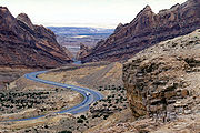
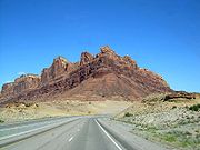
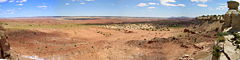
near Green River, Interstate 70 crosses a geologic feature called the San Rafael Swell
. The construction of the freeway through the swell is listed as one of the engineering marvels of the Interstate Highway System, with one engineer claiming this section as "one of the most significant highway construction feats of its time". The construction of I-70 through the swell required boring
through many solid rock canyons, cliffs, and mountains. The swell is noted for its sheer canyons and rock formations and is home to a large amount of exposed dinosaur remains. This includes the largest known collection of Jurassic era dinosaur remains at the Cleveland-Lloyd Dinosaur Quarry at the north end of the swell.
The highway ascends the western edge of the swell on a steady slope loosely following the north rim of Devils Canyon. At the top of the grade is a view area
with a view of Devils Canyon and an overlook of the country west of the swell. It then crosses Eagle Canyon via a pair of steel arch bridges. The eastbound bridge is 489 feet (149 m) long and the westbound bridge is 523 feet (159 m) long.
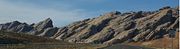
The highway then ascends Ghost Rock Summit, the highest point for I-70 inside the swell. At the summit is another view area overlooking the Little Grand Canyon of the San Rafael River. The summit is named for unusual rock formations nearby. The Ghost Rocks themselves are at 7405 feet (2,257 m), although the freeway is slightly lower. I-70 meanders through a relatively flat portion of the swell until reaching Spotted Wolf Canyon, which provides the exit route to the swell. The eastern descent features one brake check area and two runaway truck ramp
s to aid trucks down. About half way down is a view area of the canyon narrowing as it approaches the eastern escarpment
of the swell, the San Rafael Reef
. Just as the highway exits the swell it passes to the north of Goblin Valley State Park
. The highway exits the swell near Green River.
 West of Green River, US-6 and 191 join I-70. Also at Green River, the freeway reaches the southern edge of the Book Cliffs
, a mountain range which I-70 follows to Grand Junction, Colorado
. This portion of I-70 is part of the Dinosaur Diamond Prehistoric Highway, recognized as a scenic byway by both the National Scenic Byways and Utah Scenic Byways
programs. Listed attractions along the byway in the Green River area include Crystal Geyser
, Capitol Reef National Park
and Green River State Park
.
From this point east the freeway is routed across a flat area between the Book Cliffs and the Colorado River
, called Sagers Flat. Along the way it passes by the towns of Crescent Junction
, Thompson Springs
and Cisco
. Natural features visible from this portion include Arches National Park
and Castle Valley
. Other listed attractions along the byway near this section include Canyonlands National Park
and various areas with Morrison Formation
, a layer of rock where dinosaur remains are common. I-70, US-6, and US-50 all enter Colorado
concurrently. Where I-70 follows the Book Cliffs, it was built parallel to or on top of US-6/50.
, a trade route between Santa Fe, New Mexico
and Los Angeles, California
. The trail was in common use before the Mexican-American War in 1848. Although the trail serves a different route than I-70, they were both intended to connect southern California with points further east. I-70 generally parallels the route of the Old Spanish Trail west of Crescent Junction
. I-15 south of the junction with I-70 also generally parallels the trail.
, founder of the Denver and Rio Grande Western Railroad
(D&RG). Palmer started a project in 1880 to make what had been a local railroad from Colorado into a transcontinental railroad empire. This would mean a second transcontinental railroad would be built across Utah. This would also place the D&RG in competition with the First Transcontinental Railroad
, then operated by Union Pacific Railroad
and Central Pacific Railroad
. Disagreements in the company led to two proposals. Both proposals called for extending the railroad west from Colorado as far as what is now Green River. West of Green River a "northern route" would extend the railroad towards Ogden, Utah
, there connecting with the established Overland Route
. This proposal was eventually completed as the Utah Division
, loosely following the route of modern U.S. Route 6 across eastern Utah. This line soon became the main line of the D&RG and remains one of the main transcontinental rail arteries of the U.S, now operated by the Union Pacific Railroad as the Central Corridor
.
The second proposal was a "southern route" that would continue due west from Green River and head towards Los Angeles, similar to the route of modern I-70. This proposal would require extending the railroad farther west, to connect with what would become the Los Angeles and Salt Lake Railroad
.
 Due to disagreements in management and poor communication, construction began on both routes. It was soon obvious that the southern route was unfeasible given the remote area, technology available at the time and the rough terrain of the San Rafael Swell. The D&RG spent $217,470 (1883, equivalent to $4.6 million in 2007) on the project before declaring it a failure. One of the accounts in the book Utah Ghost Rails states the railroad fired the lead surveyor
, even though the workers had graded a path past the San Rafael Reef
. This route today is a jeep trail
. According to a sign placed by the Bureau of Land Management
(BLM), had the southern route succeeded it would have been the shortest transcontinental railroad in the U.S.
Construction resumed in 1901 on a portion of the southern route, to build a spur line to service coal mines on the Wasatch Plateau. The railroad branched from an existing line at Salina and traveled east up Salina Canyon. After the mines closed, the railroad bed was used to improve State Route 10
, between Salina and Fremont Junction. I-70 would later use the railroad bed for a path across the Wasatch Plateau.
was in the planning stages, no paved road had yet entered the San Rafael Swell
. The established highway through the area was US-6/US-50 which, like the railroad, entered Utah from Colorado and turned north around the swell.
 As first proposed in 1956, the western terminus of I-70 was Denver, Colorado
. Officials from Colorado pressured the federal government to extend the plans for I-70 further west. After several discussions with Utah officials, Utah supported an extension that would follow US-6/50 (now US-6), to connect with I-15 at Spanish Fork
. This proposal would connect the Salt Lake City
area with Denver. While accepting the Colorado/Utah proposal, federal planners also decided to show a modified proposal, with the terminus of I-70 at Cove Fort
, to planners at the Department of the Army. The planners opposed the extension to Salt Lake, but felt the modified proposal would benefit the U.S. Army, by providing a better connection to southern California. The new route would shorten the distance between Los Angeles and Denver by about 200 miles (321.9 km). The route to Cove Fort was approved on October 18, 1957. A general announcement was made, with no prior notice given to Utah officials of the modification. The commissioner of the Bureau of Public Roads later admitted that the lack of notice was intentional, fearing infighting if the bureau did not announce a final decision.
A state historian stated the news hit Utah "like a bombshell". Except for the officials in Utah that represented the area, most opposed a freeway that would serve no populated areas in the state. The route was mocked as a public relations blunder and a "road to nowhere". Utah officials attempted to revert plans to their preferred alternative, but later resigned to construct I-70 on the federally selected route. Governor George Dewey Clyde
concluded, "Utah had no choice but to accept the Cove Fort routing, or have none at all." Even attempts to route the freeway slightly north, to serve more cities in Emery County
, were blocked. Federal planners insisted the freeway pass Green River on a southwest course and not turn north. Even today, there is no direct interstate link between Salt Lake and Denver. Motorists must choose between the two lane routes (US-6 or US-40
) or detour on I-80
through Wyoming
.
 With the plans for I-70 extended, a transcontinental route would again be attempted across the San Rafael Swell. The area west of Green River was so remote that survey crews followed wild horses with jeeps to survey parts of the route. According to a story told at the highway's dedication, by an engineer who surveyed the highway, his group was approached by a sheep rancher and asked what they were doing. The rancher fell over laughing when he was told they were building a freeway.
The survey crew did not use the route of the railroad past the San Rafael Reef
. However, they did use the route of the railroad across the Wasatch Plateau. The construction crews destroyed two of four tunnels when the bed was widened for the freeway. The two remaining tunnels are visible just south of the freeway and are used by a frontage road
.
Some portions of I-70 over the Pavant Range and Wasatch Plateau were opened to traffic before the portion over the San Rafael Swell. These portions were temporarily signed as State Route 4. The portion over the San Rafael Swell opened to traffic in 1970, finally making the Utah portion of I-70 a drivable route.
Interstate 70 was dedicated on December 5, 1970, at the Ghost Rocks view area inside the swell, even though it would take another 20 years to fully complete the freeway. At the ceremony the mayors of cities recently made neighbors, including Grand Junction, Colorado
, introduced themselves. Then Governor Calvin L. Rampton
noted that I-70 was the longest road the U.S. had built over a completely new route since the Alaska Highway
, during World War II
. It was also noted this was the longest piece of the Interstate Highway System to open at a given time.
.png) Initially only two lanes, now the eastbound lanes, through the swell were constructed. The official highway map for Utah noted the new freeway, but qualified its existence with the words "two lanes open". The first portions of I-70 to be constructed to Interstate Highway standards
Initially only two lanes, now the eastbound lanes, through the swell were constructed. The official highway map for Utah noted the new freeway, but qualified its existence with the words "two lanes open". The first portions of I-70 to be constructed to Interstate Highway standards
were along the non-disputed portion of the route east of Green River.
The Utah portion of I-70 was not completed to Interstate Highway standards until 1990, when the second Eagle Canyon bridge was dedicated. A second dedication ceremony was held at the bridge declaring the Utah portion of I-70 complete. Archie Hamilton, one of three engineers who worked for Utah Department of Transportation
(UDOT) long enough to see I-70 progress from conception to completion, said the most memorable moment was seeing the excavation
at Spotted Wolf Canyon. He said before construction began, he could stand in one spot and touch both sides of the canyon. To carve the first 8 miles (12.9 km) through the canyon required excavating 3500000 cubic yards (2,675,942 m³) of rock. It was estimated construction cost for the San Rafael Swell portion was $183.5 million, $105.5 million (1970, $595 million in 2008) to build the first two lanes, and $78 million (1990, $130 million in 2008) to construct the rest. At the 1970 dedication, it was noted the cost of land acquisition helped to offset the cost of the massive excavation. UDOT acquired the right of way to build the majority of I-70 from the BLM at the lowest cost per mile of any highway in Utah.
. Previously these were isolated farming communities, whose residents felt they were unaccustomed to the crime and other effects that a transcontinental highway can bring. Residents of Richfield soon started to call I-70 "Cocaine Lane". The mayor stated that I-70 is a mixed blessing. He stated the highway is a boon to the hospitality industry and has made Richfield more accessible to other cities. However, the new road brought types of crime previously unknown to the city. The mayor lamented that after the completion of I-70, many residents started locking their doors for the first time. The interview resulted from an event that served as a "wake-up call", that rural Utah is "not isolated from crime". Panic ensued after the public witnessed Utah Highway Patrol
troopers carrying away a suspect in handcuffs, while removing plastic bags and coolers full of body parts from the trunk of his car. The event caused a frenzy of people checking on their neighbors, fearing the murder victims were local residents. In 2007, there were 11 violent crimes in Sevier County, a county of 19,386 residents.
Green River is the largest, and only incorporated, city directly served by I-70 in eastern Utah. Unlike the communities of the Sevier Valley, Green River was founded as a stopover for travelers along transcontinental arteries. The area was first used as a stopover for travelers navigating the Green River. Later the town was formed to serve travelers along the Old Spanish Trail and stagecoach mail routes. Green River was an established stopover by the time the railroad and later highways were built through the area.
 Before the construction of I-70 the San Rafael Swell was relatively inaccessible and not well known or explored. There were, however, a few efforts to protect the swell as early as 1935. Since the construction of the freeway the number of visitors to the swell has increased significantly, as the swell can now be accessed by automobile. As such, several groups are increasing efforts for protected status of the area, via National Park
, National Monument
or wilderness designation.
A major push occurred in 2002 when officials from Emery County
, joined by Utah governor Mike Leavitt, petitioned President George W. Bush
to use the authority of the Antiquities Act
and create a San Rafael Swell National Monument. This effort lost momentum after the governor promised to honor the wishes of Emery County residents via a non-binding referendum
, which did not pass. Common reasons given by residents for opposing the designation included fear of the federal government restricting access and a repetition of events that occurred with the Grand Staircase-Escalante National Monument
. This monument was established in 1996, by President Bill Clinton
. In that case the monument was proposed at the federal level in secret. Boundaries were drawn without the consent or even knowledge of local residents. This incited anger and triggered a backlash in rural Utah.
Currently most of the swell is administered by the BLM
and is not given special consideration. A small portion on the eastern edge is protected as Goblin Valley State Park
, administered by the Utah Division of Parks and Recreation
. Today the Southern Utah Wilderness Alliance
continues to lobby for protection.
(former US-91) at Cove Fort and US-89 at Sevier, had been taken over by the state on August 2, 1912, and assigned the label by the early 1920s as part of Utah's initial highway numbering. In the Wasatch Plateau, the base for I-70 was derived from a portion of SR-10
. Both of these were transferred to State Route 4, which was the state legislative designation for all of I-70 in Utah, in 1962. U.S. Route 50 was changed to overlap with Interstate 70 through most of Utah in 1976, with U.S. Route 6 remaining on its former route. In 1977, Utah renumbered its state routes
so that the legislative and signed numbers would match. With this change, the state designation for Interstate 70 is now State Route 70.
Interstate Highway System
The Dwight D. Eisenhower National System of Interstate and Defense Highways, , is a network of limited-access roads including freeways, highways, and expressways forming part of the National Highway System of the United States of America...
in the United States
United States
The United States of America is a federal constitutional republic comprising fifty states and a federal district...
connecting Utah
Utah
Utah is a state in the Western United States. It was the 45th state to join the Union, on January 4, 1896. Approximately 80% of Utah's 2,763,885 people live along the Wasatch Front, centering on Salt Lake City. This leaves vast expanses of the state nearly uninhabited, making the population the...
and Maryland
Maryland
Maryland is a U.S. state located in the Mid Atlantic region of the United States, bordering Virginia, West Virginia, and the District of Columbia to its south and west; Pennsylvania to its north; and Delaware to its east...
. The Utah section runs east–west for 232.15 miles (373.61 km) across the central part of the state. Richfield
Richfield, Utah
Richfield is a city in and the county seat of Sevier County, Utah, in the United States, and is the largest city in southern-central Utah. As of the 2010 census, the city population was 7,551. It lies in the Mormon Corridor, just off of Interstate 70 about 40 miles east of its junction with...
is the largest Utah city served by the freeway, which does not serve or connect any urban areas in the state. The freeway was built as part of a system of highways connecting Los Angeles
Los Angeles, California
Los Angeles , with a population at the 2010 United States Census of 3,792,621, is the most populous city in California, USA and the second most populous in the United States, after New York City. It has an area of , and is located in Southern California...
and the northeastern United States
Northeastern United States
The Northeastern United States is a region of the United States as defined by the United States Census Bureau.-Composition:The region comprises nine states: the New England states of Connecticut, Maine, Massachusetts, New Hampshire, Rhode Island and Vermont; and the Mid-Atlantic states of New...
. I-70 was the second attempt to connect southern California to the east coast
Atlantic Coast
The Atlantic Coast is any coast fronting the Atlantic Ocean. The term differentiates the coasts of countries or continents with coastlines on more than one body of water, such as North America, South America, Africa and Europe.-See also:*Indian Ocean...
of the United States via central Utah, the first being a failed attempt to construct a transcontinental railroad
Transcontinental railroad
A transcontinental railroad is a contiguous network of railroad trackage that crosses a continental land mass with terminals at different oceans or continental borders. Such networks can be via the tracks of either a single railroad, or over those owned or controlled by multiple railway companies...
. Parts of that effort were re-used in the laying out of the route of I-70.
Unlike most Interstate Highways, I-70 in Utah was not constructed parallel to or on top of an existing U.S. Highway. Portions of I-70 were constructed in areas where previously there were no paved roads. Because it was built over an entirely new route, I-70 has many features that are unique in the Interstate Highway System
Interstate Highway System
The Dwight D. Eisenhower National System of Interstate and Defense Highways, , is a network of limited-access roads including freeways, highways, and expressways forming part of the National Highway System of the United States of America...
. For example, the 110 miles (177 km) between Green River
Green River, Utah
Green River is a city in Emery County, Utah, United States. The population was 973 at the 2000 census.-Geography:Green River is located at , on the banks of the Green River, after which the city is named. The San Rafael Swell region is to the west of Green River, while Canyonlands National Park...
and Salina
Salina, Utah
Salina is a city in Sevier County, Utah, United States. The population was 2,393 at the 2000 census.-History:The first permanent settlers moved into the area in 1864 at the direction of leaders of the Church of Jesus Christ of Latter-day Saints...
makes up the longest distance anywhere in the Interstate Highway System with no motorist services. This same piece is noted as the longest highway in the United States built over a completely new route since the Alaska Highway
Alaska Highway
The Alaska Highway was constructed during World War II for the purpose of connecting the contiguous U.S. to Alaska through Canada. It begins at the junction with several Canadian highways in Dawson Creek, British Columbia and runs to Delta Junction, Alaska, via Whitehorse, Yukon...
, and the longest piece of Interstate Highway to open at a given time. The construction of the Utah portion of I-70 is listed as one of the engineering marvels of the Interstate Highway System.
The choice of the route had a significant impact on the character and culture of the Sevier Valley
Sevier County, Utah
As of the census of 2000, there were 18,842 people, 6,081 households, and 4,907 families residing in the county. The population density was 10 people per square mile . There were 7,016 housing units at an average density of 4 per square mile...
. It has also been a motivating factor for environmentalists to create a new National Park
National park
A national park is a reserve of natural, semi-natural, or developed land that a sovereign state declares or owns. Although individual nations designate their own national parks differently A national park is a reserve of natural, semi-natural, or developed land that a sovereign state declares or...
along the path of the highway to protect scenic areas around the route. I-70 from Green River to Grand Junction, Colorado
Grand Junction, Colorado
The City of Grand Junction is the largest city in western Colorado. It is a city with a council–manager government form that is the county seat and the most populous city of Mesa County, Colorado, United States. Grand Junction is situated west-southwest of the Colorado State Capitol in Denver. As...
is part of the Dinosaur Diamond Prehistoric Highway, making I-70 one of the few Interstate Highways to be named a National Scenic Byway
National Scenic Byway
A National Scenic Byway is a road recognized by the United States Department of Transportation for its archeological, cultural, historic, natural, recreational, and/or scenic qualities. The program was established by Congress in 1991 to preserve and protect the nation's scenic but often...
. Attractions listed by the Federal Highway Administration
Federal Highway Administration
The Federal Highway Administration is a division of the United States Department of Transportation that specializes in highway transportation. The agency's major activities are grouped into two "programs," the Federal-aid Highway Program and the Federal Lands Highway Program...
for the Dinosaur Diamond Prehistoric Highway on or near I-70 include, Arches National Park
Arches National Park
Arches National Park is a U.S. National Park in eastern Utah. It is known for preserving over 2000 natural sandstone arches, including the world-famous Delicate Arch, in addition to a variety of unique geological resources and formations....
, Canyonlands National Park
Canyonlands National Park
Canyonlands National Park is a U.S. National Park located in southeastern Utah near the town of Moab and preserves a colorful landscape eroded into countless canyons, mesas and buttes by the Colorado River, the Green River, and their respective tributaries. The park is divided into four districts:...
, Cleveland-Lloyd Dinosaur Quarry, Goblin Valley State Park
Goblin Valley State Park
Goblin Valley State Park is a state park of Utah, USA.Its eminent feature is its thousands of hoodoos and hoodoo rocks, which are formations of mushroom-shaped rock pinnacles, some as high as several meters...
and Westwater
Ruby Canyon
Ruby Canyon is a roughly 25 mile long canyon on the Colorado River located on the Colorado-Utah border in the western United States, and is a popular destination for rafting...
. The designation lists several side roads branching from I-70 that lead to dinosaur bones or footprints.
Route description
I-70 begins at a trumpet interchange with Interstate 15, near Cove FortCove Fort, Utah
Cove Fort is a fort and historical site located in Millard County, Utah. It was founded in 1867 by Ira Hinckley at the request of Brigham Young. One of its distinctive features is the use of volcanic rock in the construction of the walls, rather than the wood used in many mid-19th century...
. It then proceeds east over the Pavant Range
Pavant Range
The Pavant Range is a mountain range in central Utah east of Fillmore. The range is named for the Pahvant tribe, a branch of the Ute Indians. The tallest peak is Mine Camp Peak at . Most of the land in the Pavant range is part of Fishlake National Forest.-Transportation:The mountain range is...
, cresting at an unnamed summit
Route summit
A route summit is the highest point on a transportation route crossing higher ground. The term is often used in describing railway routes, less often in road transportation...
with an elevation of 7076 feet (2,157 m). The eastern descent from the Pavant range features bridges high above Clear Creek
Clear Creek (Utah)
Clear Creek is a creek in Utah which joins the Sevier River near the city of Sevier. It flows alongside Interstate 70 just east of where I-70 meets I-15....
and its side canyons. The longest of these bridges is the Fish Creek bridge at 1180 feet (360 m) long. The descent into Clear Creek features a brake check area and runaway truck ramp
Runaway truck ramp
A runaway truck ramp, runaway truck lane, emergency escape ramp or truck arrester bed is a traffic device that enables vehicles that are having braking problems to safely stop. It is typically a long, sand or gravel-filled lane adjacent to a road with a steep grade, and is designed to accommodate...
to aid truckers down the steep slope. The freeway then skirts the edge of Fremont Indian State Park
Fremont Indian State Park
Fremont Indian State Park is a state park of Utah, USA, which interprets archaeological remains of the Fremont culture. The park is located in Sevier County, Utah in the Clear Creek Canyon....
before entering Sevier Valley
Sevier County, Utah
As of the census of 2000, there were 18,842 people, 6,081 households, and 4,907 families residing in the county. The population density was 10 people per square mile . There were 7,016 housing units at an average density of 4 per square mile...
.
Sevier Valley
I-70 serves as the main thoroughfare of the valley, the only area traversed by the freeway in the state with more than a few hundred residents. RichfieldRichfield, Utah
Richfield is a city in and the county seat of Sevier County, Utah, in the United States, and is the largest city in southern-central Utah. As of the 2010 census, the city population was 7,551. It lies in the Mormon Corridor, just off of Interstate 70 about 40 miles east of its junction with...
is the largest city along I-70 in the state. The highway enters the valley just north of Big Rock Candy Mountain, a mountain named for a song
Big Rock Candy Mountain
Big Rock Candy Mountain, first recorded by Harry McClintock in 1928, is a song about a hobo's idea of paradise, a modern version of the medieval concept of Cockaigne...
attributed to Harry McClintock
Harry McClintock
Harry Kirby McClintock , also known as "Haywire Mac," was an American singer and poet. Born in Knoxville, Tennessee, "the son of a railroad cabinetmaker and nephew of four boomer trainmen. His drifting began when he ran away from home as a boy to join a circus...
. The highway proceeds northeast along the western edge of the valley, passing to the west of the communities of the valley, including Joseph
Joseph, Utah
Joseph is a town in Sevier County, Utah, United States. The population was 269 at the 2000 census. The town was named for Joseph A. Young, a local leader of The Church of Jesus Christ of Latter-day Saints...
, Monroe
Monroe, Utah
Monroe is a city in Sevier County, Utah, United States. The population was 2,256 at the 2010 United States Census. The city is home to both Mystic Hot Springs and South Sevier High School.-Geography:...
, Elsinore
Elsinore, Utah
Elsinore is a town in Sevier County, Utah, United States. The population was 733 at the 2000 census.-History:The community was first settled in the spring of 1874 by James C. Jensen, Jens Iver Jensen, and others. The area was settled by Danish converts to Mormonism, and named after Kronborg...
, and Richfield. As I-70 approaches Salina it cuts across the valley passing to the south of that town. The highway avoids the downtown
Downtown
Downtown is a term primarily used in North America by English speakers to refer to a city's core or central business district ....
areas of all of these cities. The portion between Richfield and Salina is the busiest, with an annual average daily traffic
Annual average daily traffic
Average Annual daily traffic, abbreviated AADT, is a measure used primarily in transportation planning and transportation engineering. It is the total volume of vehicle traffic of a highway or road for a year divided by 365 days. AADT is a useful and simple measurement of how busy the road is...
of 11,535 vehicles in 2006. In the Sevier Valley, I-70 was built parallel to U.S. Route 89.
Wasatch Plateau
U.S. Route 50 in Utah
The Utah portion of U.S. Route 50, commonly abbreviated US-50, crosses the center of the state. The highway serves no major population centers in Utah, with the largest city along its path being Delta. Most of the route passes through desolate, remote areas. Through the eastern half of the state...
joins I-70, and the two highways run concurrent
Concurrency (road)
A concurrency, overlap, or coincidence in a road network is an instance of one physical road bearing two or more different highway, motorway, or other route numbers...
for the rest of the way through Utah. After leaving Salina I-70 departs on a 110 miles (177 km) course to Green River. This is the longest distance in the Interstate Highway System
Interstate Highway System
The Dwight D. Eisenhower National System of Interstate and Defense Highways, , is a network of limited-access roads including freeways, highways, and expressways forming part of the National Highway System of the United States of America...
with no motorist services. The route to Green River crosses two major geographic obstacles, the Wasatch Plateau and the San Rafael Swell
San Rafael Swell
The San Rafael Swell is a large geologic feature located in south-central Utah, USA about 30 miles west of Green River, Utah. The San Rafael Swell, approximately by , consists of a giant dome-shaped anticline of sandstone, shale, and limestone that was pushed up during the Paleocene Laramide...
.
I-70 ascends the Wasatch Plateau via Salina Canyon. The top of the canyon is the highest point of any of Utah's Interstate Highways, although the elevation differs from source to source. The Utah Department of Transportation
Utah Department of Transportation
The Utah Department of Transportation is an agency of the state government for the U.S. state of Utah. The agency is usually referred to by its initials UDOT . UDOT is charged with maintaining the network of state highways in Utah. The agency is headquartered in the Calvin L. Rampton state office...
(UDOT) has listed the elevation at 7923 feet (2,415 m) and 7886 feet (2,404 m). Other maps have listed the figure 7980 feet (2,432 m). At least one map has given this point a name, Emigrant Pass. This portion of I-70 is on protected lands as part of Fishlake National Forest
Fishlake National Forest
Fishlake National Forest is located in south central Utah, USA. Its namesake is the largest freshwater mountain lake in the state.-Geography:...
. The freeway exits the Wasatch Plateau at Fremont Junction, the name of the junction of I-70 with State Route 10
Utah State Route 10
State Route 10 is a State Highway in the U.S. state of Utah. The highway follows a long valley in Eastern Utah between the Wasatch Plateau on the west and the San Rafael Swell on the east....
.
San Rafael Swell
Between Fremont Junction and the junction of SR-24Utah State Route 24
State Route 24 is a state highway in south central Utah which runs south from Salina through Sevier County then east through Wayne County and north east through Emery County...
near Green River, Interstate 70 crosses a geologic feature called the San Rafael Swell
San Rafael Swell
The San Rafael Swell is a large geologic feature located in south-central Utah, USA about 30 miles west of Green River, Utah. The San Rafael Swell, approximately by , consists of a giant dome-shaped anticline of sandstone, shale, and limestone that was pushed up during the Paleocene Laramide...
. The construction of the freeway through the swell is listed as one of the engineering marvels of the Interstate Highway System, with one engineer claiming this section as "one of the most significant highway construction feats of its time". The construction of I-70 through the swell required boring
Boring (earth)
Boring is drilling a hole, tunnel, or well in the earth.-Earth boring:Boring is used for a wide variety of applications in geology, agriculture, hydrology, civil engineering, and oil and natural gas industries...
through many solid rock canyons, cliffs, and mountains. The swell is noted for its sheer canyons and rock formations and is home to a large amount of exposed dinosaur remains. This includes the largest known collection of Jurassic era dinosaur remains at the Cleveland-Lloyd Dinosaur Quarry at the north end of the swell.
The highway ascends the western edge of the swell on a steady slope loosely following the north rim of Devils Canyon. At the top of the grade is a view area
Rest area
A rest area, travel plaza, rest stop, or service area is a public facility, located next to a large thoroughfare such as a highway, expressway, or freeway at which drivers and passengers can rest, eat, or refuel without exiting on to secondary roads...
with a view of Devils Canyon and an overlook of the country west of the swell. It then crosses Eagle Canyon via a pair of steel arch bridges. The eastbound bridge is 489 feet (149 m) long and the westbound bridge is 523 feet (159 m) long.
The highway then ascends Ghost Rock Summit, the highest point for I-70 inside the swell. At the summit is another view area overlooking the Little Grand Canyon of the San Rafael River. The summit is named for unusual rock formations nearby. The Ghost Rocks themselves are at 7405 feet (2,257 m), although the freeway is slightly lower. I-70 meanders through a relatively flat portion of the swell until reaching Spotted Wolf Canyon, which provides the exit route to the swell. The eastern descent features one brake check area and two runaway truck ramp
Runaway truck ramp
A runaway truck ramp, runaway truck lane, emergency escape ramp or truck arrester bed is a traffic device that enables vehicles that are having braking problems to safely stop. It is typically a long, sand or gravel-filled lane adjacent to a road with a steep grade, and is designed to accommodate...
s to aid trucks down. About half way down is a view area of the canyon narrowing as it approaches the eastern escarpment
Escarpment
An escarpment is a steep slope or long cliff that occurs from erosion or faulting and separates two relatively level areas of differing elevations.-Description and variants:...
of the swell, the San Rafael Reef
San Rafael Reef
The San Rafael Reef is a geologic feature located in Emery County in central Utah, part of the Colorado Plateau. Approximately 75 miles long, it is the name given to the distinctive eastern edge of the San Rafael Swell...
. Just as the highway exits the swell it passes to the north of Goblin Valley State Park
Goblin Valley State Park
Goblin Valley State Park is a state park of Utah, USA.Its eminent feature is its thousands of hoodoos and hoodoo rocks, which are formations of mushroom-shaped rock pinnacles, some as high as several meters...
. The highway exits the swell near Green River.
Book Cliffs
Book Cliffs
The Book Cliffs are a series of mountains and cliffs in western Colorado and eastern Utah, in the western United States. They are so named because many of them have the triangular appearance of a book that has been opened up, then turned on its sides and set to rest on the open sides of the book,...
, a mountain range which I-70 follows to Grand Junction, Colorado
Grand Junction, Colorado
The City of Grand Junction is the largest city in western Colorado. It is a city with a council–manager government form that is the county seat and the most populous city of Mesa County, Colorado, United States. Grand Junction is situated west-southwest of the Colorado State Capitol in Denver. As...
. This portion of I-70 is part of the Dinosaur Diamond Prehistoric Highway, recognized as a scenic byway by both the National Scenic Byways and Utah Scenic Byways
Utah Scenic Byways
The legislature in the U.S. state of Utah has designated a system of Utah Scenic Byways in addition to the National Scenic Byways that are defined within the state. Some of the state designated routes overlap with the federal designations...
programs. Listed attractions along the byway in the Green River area include Crystal Geyser
Crystal Geyser
Crystal Geyser is located on the east bank of the Green River approximately 4.5 miles downstream from Green River, Utah. It is a rare example of a cold water carbon dioxide driven geyser; geothermal activity does not play a role in the activity of the geyser...
, Capitol Reef National Park
Capitol Reef National Park
Capitol Reef National Park is a United States National Park, in south-central Utah. It is 100 miles long but fairly narrow. The park, established in 1971, preserves 378 mi² and is open all year, although May through September are the most popular months.Called "Wayne Wonderland" in the 1920s...
and Green River State Park
Green River State Park
Green River State Park is a state park of Utah, USA, located in the town of Green River. The park consists of a nine-hole golf course, a campground shaded with cottonwood trees, and a boat ramp. The Green River hosts catfish, carp, and four unique native fish that are threatened with extinction...
.
From this point east the freeway is routed across a flat area between the Book Cliffs and the Colorado River
Colorado River
The Colorado River , is a river in the Southwestern United States and northwestern Mexico, approximately long, draining a part of the arid regions on the western slope of the Rocky Mountains. The watershed of the Colorado River covers in parts of seven U.S. states and two Mexican states...
, called Sagers Flat. Along the way it passes by the towns of Crescent Junction
Crescent Junction, Utah
Crescent Junction is a small unincorporated community within Grand County in the eastern part of the U.S. state of Utah. The community is located at above sea level. Most highway maps use the name Crescent Junction, as the name given to the junction of Interstate 70 and U.S. Route 191...
, Thompson Springs
Thompson Springs, Utah
Thompson Springs, also known as Thompson, is a small census-designated place in central Grand County, Utah, United States. The population was 39 at the 2010 census. The town is just north of the east-west highway route shared by Interstate 70, U.S. Route 6 and U.S. Route 50, between Crescent...
and Cisco
Cisco, Utah
Cisco is a ghost town in Grand County, Utah near the junction of State Route 128 and Interstate 70. At one time the town served as a saloon and water-refilling station for the Denver and Rio Grande Western Railroad. The town's demise came with the demise of the steam locomotive. The town site...
. Natural features visible from this portion include Arches National Park
Arches National Park
Arches National Park is a U.S. National Park in eastern Utah. It is known for preserving over 2000 natural sandstone arches, including the world-famous Delicate Arch, in addition to a variety of unique geological resources and formations....
and Castle Valley
Castle Valley, Utah
Castle Valley is a town in Grand County, Utah, United States. The population was 349 at the 2000 census. The town is about 16 miles northeast of Moab near State Route 128.-Geography:Castle Valley is located at ....
. Other listed attractions along the byway near this section include Canyonlands National Park
Canyonlands National Park
Canyonlands National Park is a U.S. National Park located in southeastern Utah near the town of Moab and preserves a colorful landscape eroded into countless canyons, mesas and buttes by the Colorado River, the Green River, and their respective tributaries. The park is divided into four districts:...
and various areas with Morrison Formation
Morrison Formation
The Morrison Formation is a distinctive sequence of Late Jurassic sedimentary rock that is found in the western United States, which has been the most fertile source of dinosaur fossils in North America. It is composed of mudstone, sandstone, siltstone and limestone and is light grey, greenish...
, a layer of rock where dinosaur remains are common. I-70, US-6, and US-50 all enter Colorado
Colorado
Colorado is a U.S. state that encompasses much of the Rocky Mountains as well as the northeastern portion of the Colorado Plateau and the western edge of the Great Plains...
concurrently. Where I-70 follows the Book Cliffs, it was built parallel to or on top of US-6/50.
Old Spanish Trail
The first route through this portion of Utah was the Old Spanish TrailOld Spanish Trail (trade route)
The Old Spanish Trail is a historical trade route which connected the northern New Mexico settlements near or in Santa Fe, New Mexico with that of Los Angeles, California and southern California. Approximately long, it ran through areas of high mountains, arid deserts, and deep canyons. It is...
, a trade route between Santa Fe, New Mexico
Santa Fe, New Mexico
Santa Fe is the capital of the U.S. state of New Mexico. It is the fourth-largest city in the state and is the seat of . Santa Fe had a population of 67,947 in the 2010 census...
and Los Angeles, California
Los Angeles, California
Los Angeles , with a population at the 2010 United States Census of 3,792,621, is the most populous city in California, USA and the second most populous in the United States, after New York City. It has an area of , and is located in Southern California...
. The trail was in common use before the Mexican-American War in 1848. Although the trail serves a different route than I-70, they were both intended to connect southern California with points further east. I-70 generally parallels the route of the Old Spanish Trail west of Crescent Junction
Crescent Junction, Utah
Crescent Junction is a small unincorporated community within Grand County in the eastern part of the U.S. state of Utah. The community is located at above sea level. Most highway maps use the name Crescent Junction, as the name given to the junction of Interstate 70 and U.S. Route 191...
. I-15 south of the junction with I-70 also generally parallels the trail.
Transcontinental railroads
The first attempt to build a modern trade route through the area is credited to William Jackson PalmerWilliam Jackson Palmer
William Jackson Palmer was an American civil engineer, soldier, industrialist, and philanthropist.-Overview:...
, founder of the Denver and Rio Grande Western Railroad
Denver and Rio Grande Western Railroad
The Denver & Rio Grande Western Railroad , often shortened to Rio Grande or D&RGW, formerly the Denver & Rio Grande Railroad, is a defunct U.S. railroad company. The railroad started as a narrow gauge line running south from Denver, Colorado in 1870; however, served mainly as a transcontinental...
(D&RG). Palmer started a project in 1880 to make what had been a local railroad from Colorado into a transcontinental railroad empire. This would mean a second transcontinental railroad would be built across Utah. This would also place the D&RG in competition with the First Transcontinental Railroad
First Transcontinental Railroad
The First Transcontinental Railroad was a railroad line built in the United States of America between 1863 and 1869 by the Central Pacific Railroad of California and the Union Pacific Railroad that connected its statutory Eastern terminus at Council Bluffs, Iowa/Omaha, Nebraska The First...
, then operated by Union Pacific Railroad
Union Pacific Railroad
The Union Pacific Railroad , headquartered in Omaha, Nebraska, is the largest railroad network in the United States. James R. Young is president, CEO and Chairman....
and Central Pacific Railroad
Central Pacific Railroad
The Central Pacific Railroad is the former name of the railroad network built between California and Utah, USA that formed part of the "First Transcontinental Railroad" in North America. It is now part of the Union Pacific Railroad. Many 19th century national proposals to build a transcontinental...
.
Ogden, Utah
Ogden is a city in Weber County, Utah, United States. Ogden serves as the county seat of Weber County. The population was 82,825 according to the 2010 Census. The city served as a major railway hub through much of its history, and still handles a great deal of freight rail traffic which makes it a...
, there connecting with the established Overland Route
Overland Route (Union Pacific Railroad)
The Overland Route was a train route operated jointly by the Union Pacific Railroad and the Central Pacific Railroad / Southern Pacific Railroad, between Council Bluffs, Iowa / Omaha, Nebraska, and San Francisco, California over the grade of the First Transcontinental Railroad which had been...
. This proposal was eventually completed as the Utah Division
Utah Division (D&RGW)
The Utah Division of the former Denver and Rio Grande Western Railroad is a rail line that connects Grand Junction, Colorado and Salt Lake City, Utah in the Western United States. It is now incorporated into the Union Pacific Railroad system as its Green River and Provo Subdivisions, forming a...
, loosely following the route of modern U.S. Route 6 across eastern Utah. This line soon became the main line of the D&RG and remains one of the main transcontinental rail arteries of the U.S, now operated by the Union Pacific Railroad as the Central Corridor
Central Corridor (Union Pacific Railroad)
The Central Corridor is a rail line operated by the Union Pacific Railroad from near Winnemucca, Nevada to Denver, Colorado in the western United States. The line is in use for freight, and provides the route of the California Zephyr. The BNSF Railway has trackage rights on the entire line. The...
.
The second proposal was a "southern route" that would continue due west from Green River and head towards Los Angeles, similar to the route of modern I-70. This proposal would require extending the railroad farther west, to connect with what would become the Los Angeles and Salt Lake Railroad
Los Angeles and Salt Lake Railroad
The Los Angeles and Salt Lake Railroad was a rail company that completed and operated a railway line between its namesake cities, via Las Vegas, Nevada. Incorporated in Utah in 1901 as the San Pedro, Los Angeles and Salt Lake Railroad, the line was largely the brainchild of William Andrews Clark,...
.
Surveying
See Also: Public Land Survey SystemSurveying or land surveying is the technique, profession, and science of accurately determining the terrestrial or three-dimensional position of points and the distances and angles between them...
, even though the workers had graded a path past the San Rafael Reef
San Rafael Reef
The San Rafael Reef is a geologic feature located in Emery County in central Utah, part of the Colorado Plateau. Approximately 75 miles long, it is the name given to the distinctive eastern edge of the San Rafael Swell...
. This route today is a jeep trail
Jeep trail
Roads that are only suitable for off-road vehicles are often called jeep trails.The most famous is the Rubicon Trail located near Lake Tahoe in California. The so-called "Jeep Trail Capital of the World," however, is Ouray, Colorado...
. According to a sign placed by the Bureau of Land Management
Bureau of Land Management
The Bureau of Land Management is an agency within the United States Department of the Interior which administers America's public lands, totaling approximately , or one-eighth of the landmass of the country. The BLM also manages of subsurface mineral estate underlying federal, state and private...
(BLM), had the southern route succeeded it would have been the shortest transcontinental railroad in the U.S.
Construction resumed in 1901 on a portion of the southern route, to build a spur line to service coal mines on the Wasatch Plateau. The railroad branched from an existing line at Salina and traveled east up Salina Canyon. After the mines closed, the railroad bed was used to improve State Route 10
Utah State Route 10
State Route 10 is a State Highway in the U.S. state of Utah. The highway follows a long valley in Eastern Utah between the Wasatch Plateau on the west and the San Rafael Swell on the east....
, between Salina and Fremont Junction. I-70 would later use the railroad bed for a path across the Wasatch Plateau.
Plans for Interstate 70
By the time the Interstate Highway SystemInterstate Highway System
The Dwight D. Eisenhower National System of Interstate and Defense Highways, , is a network of limited-access roads including freeways, highways, and expressways forming part of the National Highway System of the United States of America...
was in the planning stages, no paved road had yet entered the San Rafael Swell
San Rafael Swell
The San Rafael Swell is a large geologic feature located in south-central Utah, USA about 30 miles west of Green River, Utah. The San Rafael Swell, approximately by , consists of a giant dome-shaped anticline of sandstone, shale, and limestone that was pushed up during the Paleocene Laramide...
. The established highway through the area was US-6/US-50 which, like the railroad, entered Utah from Colorado and turned north around the swell.
Denver, Colorado
The City and County of Denver is the capital and the most populous city of the U.S. state of Colorado. Denver is a consolidated city-county, located in the South Platte River Valley on the western edge of the High Plains just east of the Front Range of the Rocky Mountains...
. Officials from Colorado pressured the federal government to extend the plans for I-70 further west. After several discussions with Utah officials, Utah supported an extension that would follow US-6/50 (now US-6), to connect with I-15 at Spanish Fork
Spanish Fork, Utah
Spanish Fork is a city in Utah County, Utah, United States. It is part of the Provo–Orem, Utah Metropolitan Statistical Area. The population was 31,497 as of the 2008 census estimate.-History:Spanish Fork was settled by LDS pioneers in 1851...
. This proposal would connect the Salt Lake City
Salt Lake City, Utah
Salt Lake City is the capital and the most populous city of the U.S. state of Utah. The name of the city is often shortened to Salt Lake or SLC. With a population of 186,440 as of the 2010 Census, the city lies in the Salt Lake City metropolitan area, which has a total population of 1,124,197...
area with Denver. While accepting the Colorado/Utah proposal, federal planners also decided to show a modified proposal, with the terminus of I-70 at Cove Fort
Cove Fort, Utah
Cove Fort is a fort and historical site located in Millard County, Utah. It was founded in 1867 by Ira Hinckley at the request of Brigham Young. One of its distinctive features is the use of volcanic rock in the construction of the walls, rather than the wood used in many mid-19th century...
, to planners at the Department of the Army. The planners opposed the extension to Salt Lake, but felt the modified proposal would benefit the U.S. Army, by providing a better connection to southern California. The new route would shorten the distance between Los Angeles and Denver by about 200 miles (321.9 km). The route to Cove Fort was approved on October 18, 1957. A general announcement was made, with no prior notice given to Utah officials of the modification. The commissioner of the Bureau of Public Roads later admitted that the lack of notice was intentional, fearing infighting if the bureau did not announce a final decision.
A state historian stated the news hit Utah "like a bombshell". Except for the officials in Utah that represented the area, most opposed a freeway that would serve no populated areas in the state. The route was mocked as a public relations blunder and a "road to nowhere". Utah officials attempted to revert plans to their preferred alternative, but later resigned to construct I-70 on the federally selected route. Governor George Dewey Clyde
George Dewey Clyde
George Dewey Clyde was an American politician and the tenth Governor of Utah, serving two terms from 1957 till 1965 as a Republican....
concluded, "Utah had no choice but to accept the Cove Fort routing, or have none at all." Even attempts to route the freeway slightly north, to serve more cities in Emery County
Emery County, Utah
Emery County is a county located in the U.S. state of Utah. As of 2000 the population was 10,860, and by 2009 had been estimated to decrease to 10,629. It was named for George W. Emery, governor of the Utah Territory in 1875...
, were blocked. Federal planners insisted the freeway pass Green River on a southwest course and not turn north. Even today, there is no direct interstate link between Salt Lake and Denver. Motorists must choose between the two lane routes (US-6 or US-40
U.S. Route 40
U.S. Route 40 is an east–west United States highway. As with most routes whose numbers end in a zero, U.S. 40 once traversed the entire United States. It is one of the original 1920s U.S. Highways, and its first termini were San Francisco, California, and Atlantic City, New Jersey...
) or detour on I-80
Interstate 80
Interstate 80 is the second-longest Interstate Highway in the United States, following Interstate 90. It is a transcontinental artery running from downtown San Francisco, California to Teaneck, New Jersey in the New York City Metropolitan Area...
through Wyoming
Wyoming
Wyoming is a state in the mountain region of the Western United States. The western two thirds of the state is covered mostly with the mountain ranges and rangelands in the foothills of the Eastern Rocky Mountains, while the eastern third of the state is high elevation prairie known as the High...
.
Construction
The survey crew did not use the route of the railroad past the San Rafael Reef
San Rafael Reef
The San Rafael Reef is a geologic feature located in Emery County in central Utah, part of the Colorado Plateau. Approximately 75 miles long, it is the name given to the distinctive eastern edge of the San Rafael Swell...
. However, they did use the route of the railroad across the Wasatch Plateau. The construction crews destroyed two of four tunnels when the bed was widened for the freeway. The two remaining tunnels are visible just south of the freeway and are used by a frontage road
Frontage road
A frontage road is a non-limited access road running parallel to a higher-speed road, usually a freeway, and feeding it at appropriate points of access...
.
Some portions of I-70 over the Pavant Range and Wasatch Plateau were opened to traffic before the portion over the San Rafael Swell. These portions were temporarily signed as State Route 4. The portion over the San Rafael Swell opened to traffic in 1970, finally making the Utah portion of I-70 a drivable route.
Interstate 70 was dedicated on December 5, 1970, at the Ghost Rocks view area inside the swell, even though it would take another 20 years to fully complete the freeway. At the ceremony the mayors of cities recently made neighbors, including Grand Junction, Colorado
Grand Junction, Colorado
The City of Grand Junction is the largest city in western Colorado. It is a city with a council–manager government form that is the county seat and the most populous city of Mesa County, Colorado, United States. Grand Junction is situated west-southwest of the Colorado State Capitol in Denver. As...
, introduced themselves. Then Governor Calvin L. Rampton
Calvin L. Rampton
Calvin Lewellyn Rampton was the 11th Governor of the state of Utah from 1965 to 1977.Following his graduation from Davis High School in 1931, he took over his family's automobile business, due to his father's death that same year. He sold the business in 1933 and entered the University of Utah,...
noted that I-70 was the longest road the U.S. had built over a completely new route since the Alaska Highway
Alaska Highway
The Alaska Highway was constructed during World War II for the purpose of connecting the contiguous U.S. to Alaska through Canada. It begins at the junction with several Canadian highways in Dawson Creek, British Columbia and runs to Delta Junction, Alaska, via Whitehorse, Yukon...
, during World War II
World War II
World War II, or the Second World War , was a global conflict lasting from 1939 to 1945, involving most of the world's nations—including all of the great powers—eventually forming two opposing military alliances: the Allies and the Axis...
. It was also noted this was the longest piece of the Interstate Highway System to open at a given time.
Interstate Highway standards
Standards for Interstate Highways in the United States are defined by the American Association of State Highway and Transportation Officials in the publication A Policy on Design Standards - Interstate System...
were along the non-disputed portion of the route east of Green River.
The Utah portion of I-70 was not completed to Interstate Highway standards until 1990, when the second Eagle Canyon bridge was dedicated. A second dedication ceremony was held at the bridge declaring the Utah portion of I-70 complete. Archie Hamilton, one of three engineers who worked for Utah Department of Transportation
Utah Department of Transportation
The Utah Department of Transportation is an agency of the state government for the U.S. state of Utah. The agency is usually referred to by its initials UDOT . UDOT is charged with maintaining the network of state highways in Utah. The agency is headquartered in the Calvin L. Rampton state office...
(UDOT) long enough to see I-70 progress from conception to completion, said the most memorable moment was seeing the excavation
Earthworks (engineering)
Earthworks are engineering works created through the moving or processing of quantities of soil or unformed rock.- Civil engineering use :Typical earthworks include roads, railway beds, causeways, dams, levees, canals, and berms...
at Spotted Wolf Canyon. He said before construction began, he could stand in one spot and touch both sides of the canyon. To carve the first 8 miles (12.9 km) through the canyon required excavating 3500000 cubic yards (2,675,942 m³) of rock. It was estimated construction cost for the San Rafael Swell portion was $183.5 million, $105.5 million (1970, $595 million in 2008) to build the first two lanes, and $78 million (1990, $130 million in 2008) to construct the rest. At the 1970 dedication, it was noted the cost of land acquisition helped to offset the cost of the massive excavation. UDOT acquired the right of way to build the majority of I-70 from the BLM at the lowest cost per mile of any highway in Utah.
Effect on rural Utah
In 2002, the Salt Lake Tribune interviewed the mayor of Richfield about the change I-70 brought to the Sevier ValleySevier County, Utah
As of the census of 2000, there were 18,842 people, 6,081 households, and 4,907 families residing in the county. The population density was 10 people per square mile . There were 7,016 housing units at an average density of 4 per square mile...
. Previously these were isolated farming communities, whose residents felt they were unaccustomed to the crime and other effects that a transcontinental highway can bring. Residents of Richfield soon started to call I-70 "Cocaine Lane". The mayor stated that I-70 is a mixed blessing. He stated the highway is a boon to the hospitality industry and has made Richfield more accessible to other cities. However, the new road brought types of crime previously unknown to the city. The mayor lamented that after the completion of I-70, many residents started locking their doors for the first time. The interview resulted from an event that served as a "wake-up call", that rural Utah is "not isolated from crime". Panic ensued after the public witnessed Utah Highway Patrol
Utah Highway Patrol
The Utah Highway Patrol is the functional equivalent of the state police for Utah. Its sworn members, known as Troopers are certified law enforcement officers and have statewide jurisdiction...
troopers carrying away a suspect in handcuffs, while removing plastic bags and coolers full of body parts from the trunk of his car. The event caused a frenzy of people checking on their neighbors, fearing the murder victims were local residents. In 2007, there were 11 violent crimes in Sevier County, a county of 19,386 residents.
Green River is the largest, and only incorporated, city directly served by I-70 in eastern Utah. Unlike the communities of the Sevier Valley, Green River was founded as a stopover for travelers along transcontinental arteries. The area was first used as a stopover for travelers navigating the Green River. Later the town was formed to serve travelers along the Old Spanish Trail and stagecoach mail routes. Green River was an established stopover by the time the railroad and later highways were built through the area.
Effect on the San Rafael Swell
National park
A national park is a reserve of natural, semi-natural, or developed land that a sovereign state declares or owns. Although individual nations designate their own national parks differently A national park is a reserve of natural, semi-natural, or developed land that a sovereign state declares or...
, National Monument
U.S. National Monument
A National Monument in the United States is a protected area that is similar to a National Park except that the President of the United States can quickly declare an area of the United States to be a National Monument without the approval of Congress. National monuments receive less funding and...
or wilderness designation.
A major push occurred in 2002 when officials from Emery County
Emery County, Utah
Emery County is a county located in the U.S. state of Utah. As of 2000 the population was 10,860, and by 2009 had been estimated to decrease to 10,629. It was named for George W. Emery, governor of the Utah Territory in 1875...
, joined by Utah governor Mike Leavitt, petitioned President George W. Bush
George W. Bush
George Walker Bush is an American politician who served as the 43rd President of the United States, from 2001 to 2009. Before that, he was the 46th Governor of Texas, having served from 1995 to 2000....
to use the authority of the Antiquities Act
Antiquities Act
The Antiquities Act of 1906, officially An Act for the Preservation of American Antiquities , is an act passed by the United States Congress and signed into law by Theodore Roosevelt on June 8, 1906, giving the President of the United States authority to, by executive order, restrict the use of...
and create a San Rafael Swell National Monument. This effort lost momentum after the governor promised to honor the wishes of Emery County residents via a non-binding referendum
Referendum
A referendum is a direct vote in which an entire electorate is asked to either accept or reject a particular proposal. This may result in the adoption of a new constitution, a constitutional amendment, a law, the recall of an elected official or simply a specific government policy. It is a form of...
, which did not pass. Common reasons given by residents for opposing the designation included fear of the federal government restricting access and a repetition of events that occurred with the Grand Staircase-Escalante National Monument
Grand Staircase-Escalante National Monument
The Grand Staircase-Escalante National Monument contains 1.9 million acres of land in southern Utah, the United States. There are three main regions: the Grand Staircase, the Kaiparowits Plateau, and the Canyons of the Escalante. President Bill Clinton designated the area as a U.S. National...
. This monument was established in 1996, by President Bill Clinton
Bill Clinton
William Jefferson "Bill" Clinton is an American politician who served as the 42nd President of the United States from 1993 to 2001. Inaugurated at age 46, he was the third-youngest president. He took office at the end of the Cold War, and was the first president of the baby boomer generation...
. In that case the monument was proposed at the federal level in secret. Boundaries were drawn without the consent or even knowledge of local residents. This incited anger and triggered a backlash in rural Utah.
Currently most of the swell is administered by the BLM
Bureau of Land Management
The Bureau of Land Management is an agency within the United States Department of the Interior which administers America's public lands, totaling approximately , or one-eighth of the landmass of the country. The BLM also manages of subsurface mineral estate underlying federal, state and private...
and is not given special consideration. A small portion on the eastern edge is protected as Goblin Valley State Park
Goblin Valley State Park
Goblin Valley State Park is a state park of Utah, USA.Its eminent feature is its thousands of hoodoos and hoodoo rocks, which are formations of mushroom-shaped rock pinnacles, some as high as several meters...
, administered by the Utah Division of Parks and Recreation
Utah State Parks
Utah State Parks is the common name for the Division of Utah State Parks and Recreation; a division of the Utah Department of Natural Resources. This is the state agency that manages the state park system of the U.S...
. Today the Southern Utah Wilderness Alliance
Southern Utah Wilderness Alliance
The Southern Utah Wilderness Alliance is a wilderness preservation organization in the United States based in Salt Lake City, Utah, with field offices in Washington, D.C. and Moab, Utah...
continues to lobby for protection.
Route number changes
Before the formation of I-70, there was a road over the Pavant Range numbered SR-13 that was similar to the route of I-70. The highway, which largely still exists as a two-lane road between SR-161Utah State Route 161
State Route 161 is a long state highway, designated as a rural major connector, completely within Millard County in central Utah. The highway connects Interstate 70 to I-15 while providing service to historic Cove Fort. The route was once part of U.S...
(former US-91) at Cove Fort and US-89 at Sevier, had been taken over by the state on August 2, 1912, and assigned the label by the early 1920s as part of Utah's initial highway numbering. In the Wasatch Plateau, the base for I-70 was derived from a portion of SR-10
Utah State Route 10
State Route 10 is a State Highway in the U.S. state of Utah. The highway follows a long valley in Eastern Utah between the Wasatch Plateau on the west and the San Rafael Swell on the east....
. Both of these were transferred to State Route 4, which was the state legislative designation for all of I-70 in Utah, in 1962. U.S. Route 50 was changed to overlap with Interstate 70 through most of Utah in 1976, with U.S. Route 6 remaining on its former route. In 1977, Utah renumbered its state routes
1977 Utah state route renumbering
In 1977, the Utah State Legislature changed its system of how state route numbers were used and assigned. Prior to 1977 Utah used a system where every U.S. Highway and Interstate Highway traversing the state was also assigned a different Utah state route number. This state route number was not...
so that the legislative and signed numbers would match. With this change, the state designation for Interstate 70 is now State Route 70.
Exit list
External links
- Utah@Rocky Mountain Roads – Interstate 70 Photo guide for I-70 in Utah by Rocky Mountain Roads.com