
.gif)
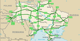
International Highways (Ukraine)
Encyclopedia
Roads in Ukraine
is a network of roads for public use, for official use, for private use, and streets with city roads. There are three types of roads national, local, and streets. Each type has additional classifications. High-speed highways such as motorways or freeways are rare and only available on selected segments of major routes.
After the fall of the Soviet Union
at the end of 1991 all road service state organizations within Ukraine were reorganized. The highway numbering system was changed as well by late 1990s. Today more and more cities install their own beltways or ringways
to improve their traffic conditions.
Ukravtodor is the state governing body of automobile roads in Ukraine. It is supplemented by a project institute Ukrhiprodor which designs objects of road management. Ukravtodor is supervised by the Ministry of Transportation and Communications. On February 28, 2002 by the Presidential order there was created a state owned open stock company Avtomobilni dorohy Ukrainy (ADU). The company is directly involved in road construction and maintenance. It consists of 32 daughter-companies in each oblast, Crimea, and the cities of national importance. The annual budget of ADU is around 4 billion hryvnias (end of 2000s).
and were part of the Soviet network of highways. The network consists 99% of roads for public use with 12% assigned as of state importance and 87% - local importance.
The state importance roads have three indexes M, H, P, each stand for the respected letter of the Cyrillic alphabet
. The state importance roads are utilized by the European E-network of highways.
The M-network of roads which stands for International network along with H-network (National) range from 01 to 23 and consist of two digits. These highways are designed for the major transportation corridors across the country and the European highway system.
The P-network (Regional) of roads ranges from 01 to 65 and also is a combination of two digits.
- Boryspil
which connected the capital with its major airport and another one - Kharkiv
- Dnipropetrovsk
. Kiev-Boryspil stretches for 18 km (11.2 mi) and has an ability to allow the traffic volume of 40,000 vehicles on daily basis (24 hrs). It is part of the M03 highway. Important supplemental feature of the automagistral is an electronic informational system that allows to inform the traveling drivers of any updates on the route. That experimental project was installed in 2007 and cost 40 million hryvnia. Kharkiv-Dnipropetrovsk is part of M18 highway.
|-bgcolor="#B5E0FD"
|Categories
!IA
!IB
!II
!III
!IV
!V
|-bgcolor="#FFFFDD"
|Average traffic intensity (daily)
!>7,000
!>7,000
!>3,000-7,000
!>1,000-3,000
!>200-1,000
!<200
|-bgcolor="#DEF2FE"
|Maximum traffic intensity (daily)
!>14,000
!>14,000
!>6,000-14,000
!>2,000-6,000
!>400-2,000
!<400
|-bgcolor="#FFFFDD"
|Estimated traffic speed, km/h
!150
!120
!120
!100
!80
!60
|-bgcolor="#DEF2FE"
|Number of lanes (in both directions)
!4-6
!4-6
!2
!2
!2
!1(total)
|-bgcolor="#FFFFDD"
|Width of lanes, m
!3,75
!3,75
!3,75
!3,75
!3,5
!4,5
|-bgcolor="#DEF2FE"
|Width of median, m
!6
!5
!-
!-
!-
!-
|-bgcolor="#FFFFDD"
|Width of an edge reinforced lane on median, m
!1
!1
!-
!-
!-
!-
|-bgcolor="#DEF2FE"
|Width of an edge reinforced lane on roadside, m
!0,75
!0,75
!0,75
!0,5
!-
!-
|-bgcolor="#FFFFDD"
|Total road width, m
!28,5
!27,5
!15
!12
!10
!6
|-bgcolor="#DEF2FE"
|Radius of a curvature on a turn, m
!1,200
!800
!800
!600
!300
!150
|-bgcolor="#FFFFDD"
|Maximum lengthwise gradient, per mil
!30
!40
!40
!50
!60
!70
|-
|}>
, routes of which run not only throughout the European continent covering such remote areas as the British Isles
, but also parts of the Asian continent regions such as Middle Asia
, Caucasus mountains
, and Asia Minor
. The European routes in Ukraine mostly travel on the Ukrainian International routes network, known as M-network.
 In the list below with a green background are identified the main routes. Those are either ones that end with zero (0) or five (5). Note that odd numbers have north-south directions and even numbers - east-west. With the red background are the obsolete routes.
}
|
|
|-
|
|50 (Slovakia)/ - Uzhhorod
- – Mukacheve
- - Berehove
- - Vydok - / ... M14 (Moldova)/ - /
|
|
|-
|
|Mukacheve
- - Berehove
- - Vydok - /
|41 km
|
|-bgcolor=#D0F0C0
|
|/ - /
|
|
|-
|
|Odessa
- /(Moldova)
|
|
|-bgcolor=red
|
|Changed to
|
|
|-bgcolor=#D0F0C0
|
|/ -
|692 km
|ferry service in Odessa
|-
|
|Kherson
-
|423.6 km
|ferry service near Kerch
|-
|
|Kiev
- - Kipti - /
|
|
|-bgcolor=#D0F0C0
|
|Yalta
- - Kharkiv
– /
|777 km
|
|-
|colspan="4" align="center"|Auxiliary routes
|-
|
|/ - Lviv
|62.5 km
|
|-
|
|/ - Kiev
|486.5 km
|
|-bgcolor=red
|
|Kiev
- Hlukhiv
- Oryol
|
|
|-
|
|Hlukhiv
- Trosna
|
|
|-
|
|Mukacheve
- - Lviv
|221 km
|
|-
|
|4 (Hungary)/ - Uzhhorod
|26 km
|
|-
|
|M21 (Moldova)/ - - Znamianka
- - Oleksandriya - - Poltava
|507 km
|
|-
|
|M14 (Moldova)/ - Odessa
|58.7 km
|
|-
|
|Zhytomyr
- - Mohyliv-Podilskyi
|260 km
|
|-
|}
Notes:
and also including such as Gdansk
-Odessa
, Eurasian, Europe-Asia, ChES, and others. There exist a proposition to create a beltway around the Black Sea
, traveling through the Crimean peninsula
.
Among the Pan-European corridors system, Ukraine houses such coridors as III (Brussels
- Dresden
- Krakow
- Kiev
), V (Venice
- Budapest
- Lviv
- Kiev
), VII (The Danube river), and IX (Helsinki
- Saint-Petersburg - Gomel - Kiev
- Chisinau
- Bucharest
- Thrace).
The project was confirmed in 2007 by the Cabinet of Ministers of Ukraine as part of the 2007-2011 program of roads development in Ukraine. The route will start on the border with Hungary
at village Kosyny (Zakarpattya Oblast) and will connect to 60 kilometres (37.3 mi) south of Kiev (between Vasylkiv
and Bila Tserkva
). It is foretasted to be IA category road with the minimum of 27.5 metres (90.2 ft) total road width and four lanes (two in each direction). The route includes its major section Vinnytsia
- Kiev
which will be the first stage project. It was one of the primary construction projects for the 2007-11. The Vinnytsia - Kiev avtomagistral will be 145 kilometres (90.1 mi) long with the estimated cost of the project is around $1 billion. It also will include 114 artificial constructions such as bridges. The road is planned to be a toll road
with an alternative non-toll road running along. The whole Kosyny - Kiev project is estimated at around $5 billion and will include nine tunnels with a total length of 20 kilometres (12.4 mi) plus 389 other artificial constructions such as bridges, including 29 road interchanges.
Avtomagistal Dnipropetrovsk
- Luhansk
490 kilometre.
The project is estimated at around $5 billion and will include 875 artificial constructions such as bridges and road interchanges (30). It is planned to start the route from near Novomoskovsk
with the terminal end at the existing Russian border checkpoint Izvaryne.
Avtomagistal Odessa
- Dnipropetrovsk 559 kilometre.
Avtomagistal Yahodyn
- Khmelnytsky
350 kilometre.
Avtomagistal Vinnytsia - Dnipropetrovsk 530 kilometre.
Autobahn Odessa - Reni
261 kilometre.
New Kiev Beltway 206 kilometre.
Indexes of territorial roads of local importance and total length of all highways per oblast
|-bgcolor="#B5E0FD"
! Index
! Oblast/City
! Road length, km
! Index
! Oblast/City
! Road length, km
! Index
! Oblast/City
! Road length, km
|-bgcolor="#FFFFDD"
!01
|Crimea
!6,605
!10
|Kiev Oblast
!8,490
!20
|Ternopil Oblast
!5,063
|-bgcolor="#DEF2FE"
!02
|Vinnytsia Oblast
!9,519
!12
|Kirovohrad Oblast
!6,545
!21
|Kharkiv Oblast
!9,551>
|Volyn Oblast
!6,199
!13
|Luhansk Oblast
!5,810
!22
|Kherson Oblast
!4,950
|-bgcolor="#DEF2FE"
!04
|Dnipropetrovsk Oblast
!9,182
!14
|Lviv Oblast
!8,334
!23
|Khmelnytsky Oblast
!7,136>
|Donetsk Oblast
!8,052
!15
|Mykolaiv Oblast
!4,831
!24
|Cherkasy Oblast
!6,118
|-bgcolor="#DEF2FE"
!06
|Zhytomyr Oblast
!8,513
!16
|Odessa Oblast
!8,232
!25
|Chernihiv Oblast
!7,680>
|Zakarpattia Oblast
!3,330
!17
|Poltava Oblast
!8,836
!26
|Chernivtsi Oblast
!2,869
|-bgcolor="#DEF2FE"
!08
|Zaporizhia Oblast
!6,974
!18
|Rivne Oblast
!5,056
!27
| Sevastopol city
!>
Note that the list is arranged in the order of the Cyrillic alphabet
. For example, the territorial highway 22 in Rivne Oblast would be identified as T-18-22 where 18 is the index for the Rivne Oblast. The T-network (Territorial) as the rest of the roads networks of local importance differs per oblast, but the road numbering itself consists of two digits. The Oblast network (O-network), on the other hand, has the same concept of T-network, but the road numbering contains four digits and the code does not have the hyphen as in T-networks. For example, a highway in Kharkiv Oblast would have code O-21xxxx.
 There are two main technical terms for special routes: pidyizd and obyizd.
Ukraine
Ukraine is a country in Eastern Europe. It has an area of 603,628 km², making it the second largest contiguous country on the European continent, after Russia...
is a network of roads for public use, for official use, for private use, and streets with city roads. There are three types of roads national, local, and streets. Each type has additional classifications. High-speed highways such as motorways or freeways are rare and only available on selected segments of major routes.
Overview
The whole network of all automobile roads (highways) consists of some 172400 km (107,124.7 mi) out which 164100 km (101,967.3 mi) - have hard surface or 95.19%. The existing road network was mostly built in 1960's - 1970's. For comparison in 1940 the highway network of Ukraine consisted of 270,700 kilometers which only 10.8% contained a paved surface.After the fall of the Soviet Union
Soviet Union
The Soviet Union , officially the Union of Soviet Socialist Republics , was a constitutionally socialist state that existed in Eurasia between 1922 and 1991....
at the end of 1991 all road service state organizations within Ukraine were reorganized. The highway numbering system was changed as well by late 1990s. Today more and more cities install their own beltways or ringways
Ring road
A ring road, orbital motorway, beltway, circumferential highway, or loop highway is a road that encircles a town or city...
to improve their traffic conditions.
Ukravtodor is the state governing body of automobile roads in Ukraine. It is supplemented by a project institute Ukrhiprodor which designs objects of road management. Ukravtodor is supervised by the Ministry of Transportation and Communications. On February 28, 2002 by the Presidential order there was created a state owned open stock company Avtomobilni dorohy Ukrainy (ADU). The company is directly involved in road construction and maintenance. It consists of 32 daughter-companies in each oblast, Crimea, and the cities of national importance. The annual budget of ADU is around 4 billion hryvnias (end of 2000s).
Classifications
Ukraine has its own network of highway that were inherited from the Ukrainian SSRUkrainian SSR
The Ukrainian Soviet Socialist Republic or in short, the Ukrainian SSR was a sovereign Soviet Socialist state and one of the fifteen constituent republics of the Soviet Union lasting from its inception in 1922 to the breakup in 1991...
and were part of the Soviet network of highways. The network consists 99% of roads for public use with 12% assigned as of state importance and 87% - local importance.
The state importance roads have three indexes M, H, P, each stand for the respected letter of the Cyrillic alphabet
Cyrillic alphabet
The Cyrillic script or azbuka is an alphabetic writing system developed in the First Bulgarian Empire during the 10th century AD at the Preslav Literary School...
. The state importance roads are utilized by the European E-network of highways.
The M-network of roads which stands for International network along with H-network (National) range from 01 to 23 and consist of two digits. These highways are designed for the major transportation corridors across the country and the European highway system.
The P-network (Regional) of roads ranges from 01 to 65 and also is a combination of two digits.
Automagistrals
In Ukraine high-speed divided highways or motorways are called automagistrals which is a generic Russian-type term for high-speed road. Currently automagistrals are not designated into a separate network and are part of national level of expressway network. In the late 2000s there were installed first improved highspeed freeways such as Automagistral KievKiev
Kiev or Kyiv is the capital and the largest city of Ukraine, located in the north central part of the country on the Dnieper River. The population as of the 2001 census was 2,611,300. However, higher numbers have been cited in the press....
- Boryspil
Boryspil
Boryspil is a city located in the Kiev Oblast in northern Ukraine. Serving as the administrative center of the Boryspil Raion , the city itself is also designated as a separate raion within the oblast....
which connected the capital with its major airport and another one - Kharkiv
Kharkiv
Kharkiv or Kharkov is the second-largest city in Ukraine.The city was founded in 1654 and was a major centre of Ukrainian culture in the Russian Empire. Kharkiv became the first city in Ukraine where the Ukrainian Soviet Socialist Republic was proclaimed in December 1917 and Soviet government was...
- Dnipropetrovsk
Dnipropetrovsk
Dnipropetrovsk or Dnepropetrovsk formerly Yekaterinoslav is Ukraine's third largest city with one million inhabitants. It is located southeast of Ukraine's capital Kiev on the Dnieper River, in the south-central region of the country...
. Kiev-Boryspil stretches for 18 km (11.2 mi) and has an ability to allow the traffic volume of 40,000 vehicles on daily basis (24 hrs). It is part of the M03 highway. Important supplemental feature of the automagistral is an electronic informational system that allows to inform the traveling drivers of any updates on the route. That experimental project was installed in 2007 and cost 40 million hryvnia. Kharkiv-Dnipropetrovsk is part of M18 highway.
Road characteristics categories
Aside of classification the roads in Ukraine are categorized by the road's ability to handle a certain degree of traffic. There are five categories with roads of I category split in a and b subcategories. Also all roads of I category are considered automagistrals, however not all of them could be considered as real motorways. Around 2010 there were two major automagistrals: Kiev - Borispol and Kharkiv - Dnipropetrovsk. They are categorized as the top roads of category Ia.|Categories
!IA
!IB
!II
!III
!IV
!V
|-bgcolor="#FFFFDD"
|Average traffic intensity (daily)
!>7,000
!>7,000
!>3,000-7,000
!>1,000-3,000
!>200-1,000
!<200
|-bgcolor="#DEF2FE"
|Maximum traffic intensity (daily)
!>14,000
!>14,000
!>6,000-14,000
!>2,000-6,000
!>400-2,000
!<400
|-bgcolor="#FFFFDD"
|Estimated traffic speed, km/h
!150
!120
!120
!100
!80
!60
|-bgcolor="#DEF2FE"
|Number of lanes (in both directions)
!4-6
!4-6
!2
!2
!2
!1(total)
|-bgcolor="#FFFFDD"
|Width of lanes, m
!3,75
!3,75
!3,75
!3,75
!3,5
!4,5
|-bgcolor="#DEF2FE"
|Width of median, m
!6
!5
!-
!-
!-
!-
|-bgcolor="#FFFFDD"
|Width of an edge reinforced lane on median, m
!1
!1
!-
!-
!-
!-
|-bgcolor="#DEF2FE"
|Width of an edge reinforced lane on roadside, m
!0,75
!0,75
!0,75
!0,5
!-
!-
|-bgcolor="#FFFFDD"
|Total road width, m
!28,5
!27,5
!15
!12
!10
!6
|-bgcolor="#DEF2FE"
|Radius of a curvature on a turn, m
!1,200
!800
!800
!600
!300
!150
|-bgcolor="#FFFFDD"
|Maximum lengthwise gradient, per mil
!30
!40
!40
!50
!60
!70
|-
|}>
List of International E-road network in Ukraine
The European routes are part of the International E-road networkInternational E-road network
The international E-road network is a numbering system for roads in Europe developed by the United Nations Economic Commission for Europe . The network is numbered from E 1 up and its roads cross national borders...
, routes of which run not only throughout the European continent covering such remote areas as the British Isles
British Isles
The British Isles are a group of islands off the northwest coast of continental Europe that include the islands of Great Britain and Ireland and over six thousand smaller isles. There are two sovereign states located on the islands: the United Kingdom of Great Britain and Northern Ireland and...
, but also parts of the Asian continent regions such as Middle Asia
Middle Asia
Middle Asia is a region of Asia from the Caspian Sea in the west, to Mongolia in the east, Afghanistan in the south, and Russia in the north. The geographical term has appeared sometime prior to the 20th century in the Russian Empire and was closely associated with the Russian Turkestan and the...
, Caucasus mountains
Caucasus Mountains
The Caucasus Mountains is a mountain system in Eurasia between the Black Sea and the Caspian Sea in the Caucasus region .The Caucasus Mountains includes:* the Greater Caucasus Mountain Range and* the Lesser Caucasus Mountains....
, and Asia Minor
Asia Minor
Asia Minor is a geographical location at the westernmost protrusion of Asia, also called Anatolia, and corresponds to the western two thirds of the Asian part of Turkey...
. The European routes in Ukraine mostly travel on the Ukrainian International routes network, known as M-network.
| Highway | Route | Length in Ukraine | Notes |
|---|---|---|---|
| Hlukhiv Hlukhiv Hlukhiv or Glukhov is a historic town in Sumy region of Ukraine, just south from the Russian border . As of 2001, the city's population is 35,800... - /P-199 (Russia Russia Russia or , officially known as both Russia and the Russian Federation , is a country in northern Eurasia. It is a federal semi-presidential republic, comprising 83 federal subjects... ) |
37 km | The shortest | |
| 4 (Poland)/ - Lviv Lviv Lviv is a city in western Ukraine. The city is regarded as one of the main cultural centres of today's Ukraine and historically has also been a major Polish and Jewish cultural center, as Poles and Jews were the two main ethnicities of the city until the outbreak of World War II and the following... - - Kiev Kiev Kiev or Kyiv is the capital and the largest city of Ukraine, located in the north central part of the country on the Dnieper River. The population as of the 2001 census was 2,611,300. However, higher numbers have been cited in the press.... - - Debaltseve Debaltseve Debaltseve is a city in the Donetsk Oblast of Ukraine. Its population is 30,246 . The city was established in 1878. It has a large railway station.... - / |
The longest | ||
|
|
|-
|
|50 (Slovakia)/ - Uzhhorod
Uzhhorod
Uzhhorod or Uzhgorod is a city located in western Ukraine, at the border with Slovakia and near the border with Hungary. It is the administrative center of the Zakarpattia Oblast , as well as the administrative center of the surrounding Uzhhorodskyi Raion within the oblast...
- – Mukacheve
Mukacheve
Mukachevo or Mukacheve is a city located in the valley of the Latorica river in the Zakarpattia Oblast , in southwestern Ukraine. Serving as the administrative center of the Mukachivskyi Raion , the city itself is also designated as a separate raion within the oblast...
- - Berehove
Berehove
Berehove is a city located in the Zakarpattia Oblast in western Ukraine, near the border with Hungary.Serving as the administrative center of the Berehove Raion , the city itself is also designated as a separate raion within the oblast...
- - Vydok - / ... M14 (Moldova)/ - /
|
|
|-
|
|Mukacheve
Mukacheve
Mukachevo or Mukacheve is a city located in the valley of the Latorica river in the Zakarpattia Oblast , in southwestern Ukraine. Serving as the administrative center of the Mukachivskyi Raion , the city itself is also designated as a separate raion within the oblast...
- - Berehove
Berehove
Berehove is a city located in the Zakarpattia Oblast in western Ukraine, near the border with Hungary.Serving as the administrative center of the Berehove Raion , the city itself is also designated as a separate raion within the oblast...
- - Vydok - /
|41 km
|
|-bgcolor=#D0F0C0
|
|/ - /
|
|
|-
|
|Odessa
Odessa
Odessa or Odesa is the administrative center of the Odessa Oblast located in southern Ukraine. The city is a major seaport located on the northwest shore of the Black Sea and the fourth largest city in Ukraine with a population of 1,029,000 .The predecessor of Odessa, a small Tatar settlement,...
- /(Moldova)
|
|
|-bgcolor=red
|
|Changed to
|
|
|-bgcolor=#D0F0C0
|
|/ -
|692 km
|ferry service in Odessa
Odessa
Odessa or Odesa is the administrative center of the Odessa Oblast located in southern Ukraine. The city is a major seaport located on the northwest shore of the Black Sea and the fourth largest city in Ukraine with a population of 1,029,000 .The predecessor of Odessa, a small Tatar settlement,...
|-
|
|Kherson
Kherson
Kherson is a city in southern Ukraine. It is the administrative center of the Kherson Oblast , and is designated as its own separate raion within the oblast. Kherson is an important port on the Black Sea and Dnieper River, and the home of a major ship-building industry...
-
|423.6 km
|ferry service near Kerch
Kerch
Kerch is a city on the Kerch Peninsula of eastern Crimea, an important industrial, transport and tourist centre of Ukraine. Kerch, founded 2600 years ago, is considered as one of the most ancient cities in Ukraine.-Ancient times:...
|-
|
|Kiev
Kiev
Kiev or Kyiv is the capital and the largest city of Ukraine, located in the north central part of the country on the Dnieper River. The population as of the 2001 census was 2,611,300. However, higher numbers have been cited in the press....
- - Kipti - /
|
|
|-bgcolor=#D0F0C0
|
|Yalta
Yalta
Yalta is a city in Crimea, southern Ukraine, on the north coast of the Black Sea.The city is located on the site of an ancient Greek colony, said to have been founded by Greek sailors who were looking for a safe shore on which to land. It is situated on a deep bay facing south towards the Black...
- - Kharkiv
Kharkiv
Kharkiv or Kharkov is the second-largest city in Ukraine.The city was founded in 1654 and was a major centre of Ukrainian culture in the Russian Empire. Kharkiv became the first city in Ukraine where the Ukrainian Soviet Socialist Republic was proclaimed in December 1917 and Soviet government was...
– /
|777 km
|
|-
|colspan="4" align="center"|Auxiliary routes
|-
|
|/ - Lviv
Lviv
Lviv is a city in western Ukraine. The city is regarded as one of the main cultural centres of today's Ukraine and historically has also been a major Polish and Jewish cultural center, as Poles and Jews were the two main ethnicities of the city until the outbreak of World War II and the following...
|62.5 km
|
|-
|
|/ - Kiev
Kiev
Kiev or Kyiv is the capital and the largest city of Ukraine, located in the north central part of the country on the Dnieper River. The population as of the 2001 census was 2,611,300. However, higher numbers have been cited in the press....
|486.5 km
|
|-bgcolor=red
|
|Kiev
Kiev
Kiev or Kyiv is the capital and the largest city of Ukraine, located in the north central part of the country on the Dnieper River. The population as of the 2001 census was 2,611,300. However, higher numbers have been cited in the press....
- Hlukhiv
Hlukhiv
Hlukhiv or Glukhov is a historic town in Sumy region of Ukraine, just south from the Russian border . As of 2001, the city's population is 35,800...
- Oryol
Oryol
Oryol or Orel is a city and the administrative center of Oryol Oblast, Russia, located on the Oka River, approximately south-southwest of Moscow...
|
|
|-
|
|Hlukhiv
Hlukhiv
Hlukhiv or Glukhov is a historic town in Sumy region of Ukraine, just south from the Russian border . As of 2001, the city's population is 35,800...
- Trosna
|
|
|-
|
|Mukacheve
Mukacheve
Mukachevo or Mukacheve is a city located in the valley of the Latorica river in the Zakarpattia Oblast , in southwestern Ukraine. Serving as the administrative center of the Mukachivskyi Raion , the city itself is also designated as a separate raion within the oblast...
- - Lviv
Lviv
Lviv is a city in western Ukraine. The city is regarded as one of the main cultural centres of today's Ukraine and historically has also been a major Polish and Jewish cultural center, as Poles and Jews were the two main ethnicities of the city until the outbreak of World War II and the following...
|221 km
|
|-
|
|4 (Hungary)/ - Uzhhorod
Uzhhorod
Uzhhorod or Uzhgorod is a city located in western Ukraine, at the border with Slovakia and near the border with Hungary. It is the administrative center of the Zakarpattia Oblast , as well as the administrative center of the surrounding Uzhhorodskyi Raion within the oblast...
|26 km
|
|-
|
|M21 (Moldova)/ - - Znamianka
Znamianka
Znamianka is a city in Kirovohrad Oblast of Ukraine. Population is 29,412 .The city has a special status within the oblast, the city of oblast subordination or an oblast municipality. As a municipality it combines the city of Znamianka, the town of Znamianka Druha, and the village of Vodyane. The...
- - Oleksandriya - - Poltava
Poltava
Poltava is a city in located on the Vorskla River in central Ukraine. It is the administrative center of the Poltava Oblast , as well as the surrounding Poltava Raion of the oblast. Poltava's estimated population is 298,652 ....
|507 km
|
|-
|
|M14 (Moldova)/ - Odessa
Odessa
Odessa or Odesa is the administrative center of the Odessa Oblast located in southern Ukraine. The city is a major seaport located on the northwest shore of the Black Sea and the fourth largest city in Ukraine with a population of 1,029,000 .The predecessor of Odessa, a small Tatar settlement,...
|58.7 km
|
|-
|
|Zhytomyr
Zhytomyr
Zhytomyr is a city in the North of the western half of Ukraine. It is the administrative center of the Zhytomyr Oblast , as well as the administrative center of the surrounding Zhytomyr Raion...
- - Mohyliv-Podilskyi
Mohyliv-Podilskyi
Mohyliv-Podilskyi is a city in the Mohyliv-Podilskyi Raion of the Vinnytsia Oblast , Ukraine. It is located at , on the border with Bessarabia, Moldova.-History:The first mention of the town dates from 1595...
|260 km
|
|-
|}
Notes:
- There are also some "hidden" routes such as E-577 which coincides with E-584.
- Route is completely located within Ukraine.
Transportation corridors
The European route network creates several important transport corridors known as Pan-European corridorsPan-European corridors
The ten Pan-European transport corridors were defined at the second Pan-European transport Conference in Crete, March 1994, as routes in Central and Eastern Europe that required major investment over the next ten to fifteen years. Additions were made at the third conference in Helsinki in 1997...
and also including such as Gdansk
Gdansk
Gdańsk is a Polish city on the Baltic coast, at the centre of the country's fourth-largest metropolitan area.The city lies on the southern edge of Gdańsk Bay , in a conurbation with the city of Gdynia, spa town of Sopot, and suburban communities, which together form a metropolitan area called the...
-Odessa
Odessa
Odessa or Odesa is the administrative center of the Odessa Oblast located in southern Ukraine. The city is a major seaport located on the northwest shore of the Black Sea and the fourth largest city in Ukraine with a population of 1,029,000 .The predecessor of Odessa, a small Tatar settlement,...
, Eurasian, Europe-Asia, ChES, and others. There exist a proposition to create a beltway around the Black Sea
Black Sea
The Black Sea is bounded by Europe, Anatolia and the Caucasus and is ultimately connected to the Atlantic Ocean via the Mediterranean and the Aegean seas and various straits. The Bosphorus strait connects it to the Sea of Marmara, and the strait of the Dardanelles connects that sea to the Aegean...
, traveling through the Crimean peninsula
Crimea
Crimea , or the Autonomous Republic of Crimea , is a sub-national unit, an autonomous republic, of Ukraine. It is located on the northern coast of the Black Sea, occupying a peninsula of the same name...
.
Among the Pan-European corridors system, Ukraine houses such coridors as III (Brussels
Brussels
Brussels , officially the Brussels Region or Brussels-Capital Region , is the capital of Belgium and the de facto capital of the European Union...
- Dresden
Dresden
Dresden is the capital city of the Free State of Saxony in Germany. It is situated in a valley on the River Elbe, near the Czech border. The Dresden conurbation is part of the Saxon Triangle metropolitan area....
- Krakow
Kraków
Kraków also Krakow, or Cracow , is the second largest and one of the oldest cities in Poland. Situated on the Vistula River in the Lesser Poland region, the city dates back to the 7th century. Kraków has traditionally been one of the leading centres of Polish academic, cultural, and artistic life...
- Kiev
Kiev
Kiev or Kyiv is the capital and the largest city of Ukraine, located in the north central part of the country on the Dnieper River. The population as of the 2001 census was 2,611,300. However, higher numbers have been cited in the press....
), V (Venice
Venice
Venice is a city in northern Italy which is renowned for the beauty of its setting, its architecture and its artworks. It is the capital of the Veneto region...
- Budapest
Budapest
Budapest is the capital of Hungary. As the largest city of Hungary, it is the country's principal political, cultural, commercial, industrial, and transportation centre. In 2011, Budapest had 1,733,685 inhabitants, down from its 1989 peak of 2,113,645 due to suburbanization. The Budapest Commuter...
- Lviv
Lviv
Lviv is a city in western Ukraine. The city is regarded as one of the main cultural centres of today's Ukraine and historically has also been a major Polish and Jewish cultural center, as Poles and Jews were the two main ethnicities of the city until the outbreak of World War II and the following...
- Kiev
Kiev
Kiev or Kyiv is the capital and the largest city of Ukraine, located in the north central part of the country on the Dnieper River. The population as of the 2001 census was 2,611,300. However, higher numbers have been cited in the press....
), VII (The Danube river), and IX (Helsinki
Helsinki
Helsinki is the capital and largest city in Finland. It is in the region of Uusimaa, located in southern Finland, on the shore of the Gulf of Finland, an arm of the Baltic Sea. The population of the city of Helsinki is , making it by far the most populous municipality in Finland. Helsinki is...
- Saint-Petersburg - Gomel - Kiev
Kiev
Kiev or Kyiv is the capital and the largest city of Ukraine, located in the north central part of the country on the Dnieper River. The population as of the 2001 census was 2,611,300. However, higher numbers have been cited in the press....
- Chisinau
Chisinau
Chișinău is the capital and largest municipality of Moldova. It is also its main industrial and commercial centre and is located in the middle of the country, on the river Bîc...
- Bucharest
Bucharest
Bucharest is the capital municipality, cultural, industrial, and financial centre of Romania. It is the largest city in Romania, located in the southeast of the country, at , and lies on the banks of the Dâmbovița River....
- Thrace).
Border checkpoints
| Country | Highway | Nearest settlement | Region |
|---|---|---|---|
 Russia Russia |
Bachivsk, Hlukhiv Raion | Sumy Sumy Oblast Sumy Oblast is an oblast in the northeastern part of Ukraine. The administrative center of the oblast is the city of Sumy.Other important cities within the oblast include Konotop, Okhtyrka, Romny, and Shostka.... |
|
| Novoazovsk Novoazovsk Novoazovsk is a city, the administrative center of the Novoazovskyi Raion , in Donetsk Oblast of Ukraine. Population is 12,702 .... |
|||
| Dolzhansky | |||
| Shcherbakivka | |||
| Izvaryne, Krasnodon Krasnodon Krasnodon is a city in the Luhansk Oblast of south-eastern Ukraine. Serving as the administrative center of the Krasnodonskyi Raion , the city itself is also designated as a separate raion within the oblast.... |
Luhansk Luhansk Oblast Luhansk Oblast ) is the easternmost oblast of Ukraine. Its administrative center is Luhansk. The oblast was established in 1938 and bore the name Voroshilovgrad Oblast in honor of Kliment Voroshilov.... |
||
 Poland Poland |
Shehyni Shehyni Shehyni is a village in the Ukraine. Located at the border with Poland, it is best known as the site of the Medyka-Shehyni border crossing.- History :... , Mostyska Raion Mostyska Raion Mostyska Raion is a raion in Lviv Oblast in western Ukraine. Its administrative center is Mostyska. It has a population of 61 919.It was established in 1939.-External links:*... |
Lviv Lviv Oblast Lviv Oblast is an oblast in western Ukraine. The administrative center of the oblast is the city of Lviv.-History:The oblast was created as part of the Ukrainian Soviet Socialist Republic on December 4, 1939... |
|
| Krakovets Krakovets Krakovets is a town in Lviv Oblast in western Ukraine. It is the birthplace of the Ukrainian Insurgent Army general Roman Shukhevych.A border crossing into Poland is located at Krakovets. The town across the border in Poland is Korczowa.... , Yavoriv Raion Yavoriv Raion Yavoriv Raion is a raion in Lviv Oblast in western Ukraine. Its administrative center is Yavoriv. It has a population of 122 200.It was established in 1939.-External links:*... |
|||
| Rava-Ruska Rava-Ruska Rava-Ruska is a city in the Lviv Oblast of western Ukraine.It is located near the border with Poland, opposite the town of Hrebenne. It is located in the Zhovkva Raion at around . The current estimated population is 8,100 .... , Zhovkva Raion Zhovkva Raion Zhovkva Raion is a raion in Lviv Oblast in western Ukraine. Its administrative center is Zhovkva. It has a population of 109 173.It was established in 1940.-External links:*... |
|||
| Ustyluh Ustyluh Ustyluh is a city in Volyn Oblast, Ukraine, 8 miles west of Volodymyr-Volynskyi. Population is 2,283 .Igor Stravinsky had an estate in Ustyluh and visited it frequently between 1890 and 1914. His mansion is now a museum.... , Volodymyr-Volynskyi Raion Volodymyr-Volynskyi Raion Volodymyr-Volynskyi Raion is a raion in Volyn Oblast in western Ukraine. Its administrative center is Volodymyr Volynskyi. It has a population of 28 446.-External links:*... |
Volyn Volyn Oblast Volyn Oblast is an oblast in north-western Ukraine. Its administrative center is Lutsk. Kovel is the westernmost town and the last station in Ukraine of the rail line running from Kiev to Warsaw.-History:... |
||
| Yahodyn | |||
 Hungary Hungary |
Kosyny, Chop Chop Chop, CHOP, Chops, or CHOPS may refer to:-Music:*Embouchure, in music, a synonym for chops*CHOPS, Asian-American hip-hop producer, rapper and member of rap group Mountain Brothers*Chops , 2006... |
Zakarpattia Zakarpattia Oblast The Zakarpattia Oblast is an administrative oblast located in southwestern Ukraine. Its administrative center is the city of Uzhhorod... |
|
 Slovakia SlovakiaSlovakia - Ukraine border Slovakia - Ukraine border is an internationally established boundary between Slovakia and Ukraine. Both countries inherited it from their previous respective state organizations Ukraine from the Soviet Union, Slovakia from Czechoslavakia.... |
Uzhhorod Uzhhorod Uzhhorod or Uzhgorod is a city located in western Ukraine, at the border with Slovakia and near the border with Hungary. It is the administrative center of the Zakarpattia Oblast , as well as the administrative center of the surrounding Uzhhorodskyi Raion within the oblast... |
||
| Maly Berezny, Velykyy Bereznyi Raion Velykyy Bereznyi Raion Velykyy Bereznyi Raion is a raion in Zakarpattia Oblast in western Ukraine. Its administrative center is Velykyy Bereznyi. It has a population of 28 211.-External links:*... |
|||
 Moldova Moldova |
Kuchurhan Kuchurhan Kuchurhan is a village in the Rozdilnianskyi Raion of the Odessa Oblast in Ukraine. It is located along the Kuchurhan River at the north end of the Kuchurhan Reservoir along the border with Transnistria in Moldova... , Rozdilnianskyi Raion Rozdilnianskyi Raion The Rozdilna Raion is located in the Odessa Oblast of Ukraine. Its administrative center is the city of Rozdilna. The population of the district was 56,897 in 2001... |
||
| Mamalyha, Novoselytsia Raion | Chernivtsi Chernivtsi Oblast Chernivtsi Oblast is an oblast in western Ukraine, bordering on Romania and Moldova. It has a large variety of landforms: the Carpathian Mountains and picturesque hills at the foot of the mountains gradually change to a broad partly forested plain situated between the Dniester and Prut rivers.... |
||
| Platonove, Krasni Okny Raion | |||
| Mohyliv-Podilsky | Vinnytsia Vinnytsia Oblast Vinnytsia Oblast is an oblast of Ukraine. Its administrative center is Vinnytsia.-Geography:The area of the region is 26,500 km²; its population is 1.7 million.... |
||
 Romania Romania |
Velyka Kopanya | ||
| Reni Reni -People:* Guido Reni , Italian Baroque painter* Alan Wren , nicknamed Reni, drummer for The Stone Roses* Reni Mimura, a Japanese pop singer who is known for using cosplay in her performances.... |
Odessa Odessa Oblast Odesa Oblast, also written as Odessa Oblast , is the southernmost and largest oblast of south-western Ukraine. The administrative center of the oblast is the city of Odessa.-History:... |
||
| Terebleche | |||
 Belarus Belarus |
Domanove | ||
| Novi Yarylovychi, Ripky Raion | Chernihiv Chernihiv Oblast Chernihiv Oblast is an oblast of northern Ukraine. The administrative center of the oblast is the city of Chernihiv.-Geography:The total area of the province is around 31,900 km².... |
Important projects
Avtomagistral Kosyny - Kiev 672 kilometre.The project was confirmed in 2007 by the Cabinet of Ministers of Ukraine as part of the 2007-2011 program of roads development in Ukraine. The route will start on the border with Hungary
Hungary
Hungary , officially the Republic of Hungary , is a landlocked country in Central Europe. It is situated in the Carpathian Basin and is bordered by Slovakia to the north, Ukraine and Romania to the east, Serbia and Croatia to the south, Slovenia to the southwest and Austria to the west. The...
at village Kosyny (Zakarpattya Oblast) and will connect to 60 kilometres (37.3 mi) south of Kiev (between Vasylkiv
Vasylkiv
Vasylkiv is a city located on the Stuhna River in the Kiev Oblast in central Ukraine. Serving as the administrative center of the Vasylkivskyi Raion , the city itself is also designated as a separate raion within the oblast. A location with an over 1000 years history, it was incorporated as a...
and Bila Tserkva
Bila Tserkva
Bila Tserkva is a city located on the Ros' River in the Kiev Oblast in central Ukraine, approximately south of the capital, Kiev. Population 203,300 Area 34 km².-Administrative status:...
). It is foretasted to be IA category road with the minimum of 27.5 metres (90.2 ft) total road width and four lanes (two in each direction). The route includes its major section Vinnytsia
Vinnytsia
Vinnytsia is a city located on the banks of the Southern Bug, in central Ukraine. It is the administrative center of Vinnytsia Oblast.-Names:...
- Kiev
Kiev
Kiev or Kyiv is the capital and the largest city of Ukraine, located in the north central part of the country on the Dnieper River. The population as of the 2001 census was 2,611,300. However, higher numbers have been cited in the press....
which will be the first stage project. It was one of the primary construction projects for the 2007-11. The Vinnytsia - Kiev avtomagistral will be 145 kilometres (90.1 mi) long with the estimated cost of the project is around $1 billion. It also will include 114 artificial constructions such as bridges. The road is planned to be a toll road
Toll road
A toll road is a privately or publicly built road for which a driver pays a toll for use. Structures for which tolls are charged include toll bridges and toll tunnels. Non-toll roads are financed using other sources of revenue, most typically fuel tax or general tax funds...
with an alternative non-toll road running along. The whole Kosyny - Kiev project is estimated at around $5 billion and will include nine tunnels with a total length of 20 kilometres (12.4 mi) plus 389 other artificial constructions such as bridges, including 29 road interchanges.
Avtomagistal Dnipropetrovsk
Dnipropetrovsk
Dnipropetrovsk or Dnepropetrovsk formerly Yekaterinoslav is Ukraine's third largest city with one million inhabitants. It is located southeast of Ukraine's capital Kiev on the Dnieper River, in the south-central region of the country...
- Luhansk
Luhansk
Luhansk also known as Lugansk is a city in southeastern Ukraine. It is the administrative center of the Luhansk Oblast . The city itself is also designated as its own separate municipality within the oblast...
490 kilometre.
The project is estimated at around $5 billion and will include 875 artificial constructions such as bridges and road interchanges (30). It is planned to start the route from near Novomoskovsk
Novomoskovsk, Ukraine
Novomoskovsk is a city in the Dnipropetrovsk Oblast of Ukraine and a center of Novomoskovsk Raion . As of 2001, the city's population is 72,439....
with the terminal end at the existing Russian border checkpoint Izvaryne.
Avtomagistal Odessa
Odessa
Odessa or Odesa is the administrative center of the Odessa Oblast located in southern Ukraine. The city is a major seaport located on the northwest shore of the Black Sea and the fourth largest city in Ukraine with a population of 1,029,000 .The predecessor of Odessa, a small Tatar settlement,...
- Dnipropetrovsk 559 kilometre.
Avtomagistal Yahodyn
Poland
Poland , officially the Republic of Poland , is a country in Central Europe bordered by Germany to the west; the Czech Republic and Slovakia to the south; Ukraine, Belarus and Lithuania to the east; and the Baltic Sea and Kaliningrad Oblast, a Russian exclave, to the north...
- Khmelnytsky
Khmelnytskyi, Ukraine
Khmelnytskyi is a city in Ukraine in the region of Podillia. It is located on the Southern Buh River and about from the Ukrainian capital, Kiev. The town's original name was Płoskirów, later Proskurov, but in 1954 was renamed Khmelnytskyi. It is the center of the Khmelnytskyi Oblast in western...
350 kilometre.
Avtomagistal Vinnytsia - Dnipropetrovsk 530 kilometre.
Autobahn Odessa - Reni
Reni, Ukraine
Reni is a small town in the Odessa Oblast of western Ukraine. It is the administrative center of the Reniysky Raion , and is located in the Bessarabian historic district of Budjak. The settlement was founded around 1548, acquiring city status in 1821.The current estimated population is around...
261 kilometre.
New Kiev Beltway 206 kilometre.
Roads of the Local importance
The local importance roads have three classes as well, but only two indexes T, O. The Raion network of roads does not have a system implemented. The indexes for the local roads are also supplemented by an oblast index where they are located.! Index
! Oblast/City
! Road length, km
! Index
! Oblast/City
! Road length, km
! Index
! Oblast/City
! Road length, km
|-bgcolor="#FFFFDD"
!01
|Crimea
Crimea
Crimea , or the Autonomous Republic of Crimea , is a sub-national unit, an autonomous republic, of Ukraine. It is located on the northern coast of the Black Sea, occupying a peninsula of the same name...
!6,605
!10
|Kiev Oblast
Kiev Oblast
Kyiv Oblast, sometimes written as Kiev Oblast is an oblast in central Ukraine.The administrative center of the oblast is the city of Kyiv , also being the capital of Ukraine...
!8,490
!20
|Ternopil Oblast
Ternopil Oblast
Ternopil Oblast is an oblast' of Ukraine. Its administrative center is Ternopil, through which flows the Seret River, a tributary of the Dnister.-Geography:...
!5,063
|-bgcolor="#DEF2FE"
!02
|Vinnytsia Oblast
Vinnytsia Oblast
Vinnytsia Oblast is an oblast of Ukraine. Its administrative center is Vinnytsia.-Geography:The area of the region is 26,500 km²; its population is 1.7 million....
!9,519
!12
|Kirovohrad Oblast
Kirovohrad Oblast
Kirovohrad Oblast is an oblast of Ukraine. The administrative center of the oblast is the city of Kirovohrad.-Geography:The area of the province is , its population is 1.1 million....
!6,545
!21
|Kharkiv Oblast
Kharkiv Oblast
Kharkiv Oblast is an oblast in eastern Ukraine. The oblast borders Russia to the north, Luhansk Oblast to the east, Donetsk Oblast to the south-east, Dnipropetrovsk Oblast to the south-west, Poltava Oblast to the west and Sumy Oblast to the north-west...
!9,551>
|Volyn Oblast
Volyn Oblast
Volyn Oblast is an oblast in north-western Ukraine. Its administrative center is Lutsk. Kovel is the westernmost town and the last station in Ukraine of the rail line running from Kiev to Warsaw.-History:...
!6,199
!13
|Luhansk Oblast
Luhansk Oblast
Luhansk Oblast ) is the easternmost oblast of Ukraine. Its administrative center is Luhansk. The oblast was established in 1938 and bore the name Voroshilovgrad Oblast in honor of Kliment Voroshilov....
!5,810
!22
|Kherson Oblast
Kherson Oblast
Kherson Oblast is an oblast in southern Ukraine, just north of Crimea. Its administrative center is Kherson. The area of the region is 29000 km², its population is 1.12 million.Important cities in the oblast include:...
!4,950
|-bgcolor="#DEF2FE"
!04
|Dnipropetrovsk Oblast
Dnipropetrovsk Oblast
Dnipropetrovsk Oblast is an oblast of central Ukraine, the most important industrial region of the country. Its administrative center is Dnipropetrovsk....
!9,182
!14
|Lviv Oblast
Lviv Oblast
Lviv Oblast is an oblast in western Ukraine. The administrative center of the oblast is the city of Lviv.-History:The oblast was created as part of the Ukrainian Soviet Socialist Republic on December 4, 1939...
!8,334
!23
|Khmelnytsky Oblast
!7,136>
|Donetsk Oblast
Donetsk Oblast
Donetsk Oblast is an oblast of eastern Ukraine. Its administrative center is Donetsk. Historically, the province is an important part of the Donbas region...
!8,052
!15
|Mykolaiv Oblast
Mykolaiv Oblast
Mykolaiv Oblast is an oblast of Ukraine. The administrative center of the oblast is the city of Mykolayiv.-Geography:The Mykolaiv Oblast is located in the southern half of Ukraine...
!4,831
!24
|Cherkasy Oblast
Cherkasy Oblast
Cherkasy Oblast is an oblast of central Ukraine located along the Dnieper River. The administrative center of the oblast is the city of Cherkasy).-Geography:...
!6,118
|-bgcolor="#DEF2FE"
!06
|Zhytomyr Oblast
Zhytomyr Oblast
Zhytomyr Oblast is an oblast of northern Ukraine. The administrative center of the oblast is the city of Zhytomyr.-History:The oblast was created as part of the Ukrainian Soviet Socialist Republic on September 22, 1937....
!8,513
!16
|Odessa Oblast
Odessa Oblast
Odesa Oblast, also written as Odessa Oblast , is the southernmost and largest oblast of south-western Ukraine. The administrative center of the oblast is the city of Odessa.-History:...
!8,232
!25
|Chernihiv Oblast
Chernihiv Oblast
Chernihiv Oblast is an oblast of northern Ukraine. The administrative center of the oblast is the city of Chernihiv.-Geography:The total area of the province is around 31,900 km²....
!7,680>
|Zakarpattia Oblast
Zakarpattia Oblast
The Zakarpattia Oblast is an administrative oblast located in southwestern Ukraine. Its administrative center is the city of Uzhhorod...
!3,330
!17
|Poltava Oblast
Poltava Oblast
Poltava Oblast is an oblast of central Ukraine. The administrative center of the oblast is the city of Poltava.Other important cities within the oblast include: Komsomolsk, Kremenchuk, Lubny and Myrhorod.-Geography:...
!8,836
!26
|Chernivtsi Oblast
Chernivtsi Oblast
Chernivtsi Oblast is an oblast in western Ukraine, bordering on Romania and Moldova. It has a large variety of landforms: the Carpathian Mountains and picturesque hills at the foot of the mountains gradually change to a broad partly forested plain situated between the Dniester and Prut rivers....
!2,869
|-bgcolor="#DEF2FE"
!08
|Zaporizhia Oblast
Zaporizhia Oblast
Zaporizhia Oblast is an oblast of southern Ukraine. Its capital is Zaporizhia.This oblast is an important part of Ukraine's industry and agriculture.-Geography:...
!6,974
!18
|Rivne Oblast
Rivne Oblast
Rivne Oblast is an oblast of Ukraine. Its administrative center is Rivne. The area of the region is 20,100 km²; its population is 1.2 million...
!5,056
!27
| Sevastopol city
Sevastopol
Sevastopol is a city on rights of administrative division of Ukraine, located on the Black Sea coast of the Crimea peninsula. It has a population of 342,451 . Sevastopol is the second largest port in Ukraine, after the Port of Odessa....
!>
Note that the list is arranged in the order of the Cyrillic alphabet
Cyrillic alphabet
The Cyrillic script or azbuka is an alphabetic writing system developed in the First Bulgarian Empire during the 10th century AD at the Preslav Literary School...
. For example, the territorial highway 22 in Rivne Oblast would be identified as T-18-22 where 18 is the index for the Rivne Oblast. The T-network (Territorial) as the rest of the roads networks of local importance differs per oblast, but the road numbering itself consists of two digits. The Oblast network (O-network), on the other hand, has the same concept of T-network, but the road numbering contains four digits and the code does not have the hyphen as in T-networks. For example, a highway in Kharkiv Oblast would have code O-21xxxx.
Special routes in Ukraine
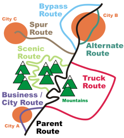
- Pidyizd route is usually an access route that splits from the main route towards an important geographic point such as city, airport, park etc. On the picture to the right it can be compared to the spur route.
- Obyizd route is a type of ring roadRing roadA ring road, orbital motorway, beltway, circumferential highway, or loop highway is a road that encircles a town or city...
which is not necessarily complete. On the picture to the right it can be compared to the bypass route, business route, truck route.
Historical routes
- Murava RouteMuravsky TrailMuravsky Trail or Murava Route was an important trade route and according to the Russian historiography a favourite invasion route of the Crimean Tatars during the Russo-Crimean Wars of the 16th and early 17th centuries. It was also used somewhat for peaceful trade...
- Bila Tserkva road
- Izyum RouteIzyumsky TrailIzyumsky Trail is a historic route used by the Crimean Tatars in the 16th and 17th centuries to penetrate into Sloboda Ukraine and then invade Muscovite Russia....
(branch of Murava route) - Silk RoadSilk RoadThe Silk Road or Silk Route refers to a historical network of interlinking trade routes across the Afro-Eurasian landmass that connected East, South, and Western Asia with the Mediterranean and European world, as well as parts of North and East Africa...
- Berlad road
- From the Varangians to the GreeksTrade route from the Varangians to the GreeksThe trade route from the Varangians to the Greeks was a trade route that connected Scandinavia, Kievan Rus' and the Byzantine Empire. The route allowed traders along the route to establish a direct prosperous trade with Byzantium, and prompted some of them to settle in the territories of...
- Chumak route
- Black route
- Romodanovsky route
- Kuchma route (branch of Black route)
- Kraków road
- Kolky route
- Kiev route
- Kalmius route (branch of Murava route)
- Zaloha route
Streets
Types of streets- vulytsia, a most common and generic type of a street within a settlement
- shose, a broad road built for high-speed traffic for big distances with limited number of points through which drivers can access it; generally accessible road, especially main road that connects cities or settlements
- prospekt, a rare term for a broad, long, and straight street in big cities, such as a parkwayParkwayThe term parkway has several distinct principal meanings and numerous synonyms around the world, for either a type of landscaped area or a type of road.Type of landscaped area:...
- bulvar, a scenic broad street, such as boulevardBoulevardA Boulevard is type of road, usually a wide, multi-lane arterial thoroughfare, divided with a median down the centre, and roadways along each side designed as slow travel and parking lanes and for bicycle and pedestrian usage, often with an above-average quality of landscaping and scenery...
- naberezhna, a street along shore or bank of sea, river, or lake
- ob'yizdna, a street around city
- provulok, a back street, small street such as side street
Source
- International Highways in Ukraine (russian, ukrainian, english languages)
- List of European routes
- Convention of road markings and signals
- Official text of the European agreement on International Highway System (E-Network)
- Declaration of the Cabinets Ministers of Ukrainian SSR of joining the European agreement on E-Network
- Law of Ukraine on automobile roads (highways), Law of Ukraine on road movement, Law of Ukraine on transport, Regulations for the international highways of the Commonwealth of Independent States
- Declaration of Cabinet of Minister of Ukraine on the tollway Lviv-Krakovets, Law of Ukraine on the tollway Kiev-Odessa
- Traffic signs in Ukraine