
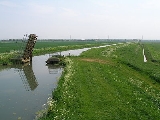
Internal Drainage Board
Encyclopedia
An internal drainage board (IDB) is a type of operating authority
which is established in areas of special drainage
need in England and Wales
with permissive powers to undertake work to secure clean water drainage and water level management within drainage district
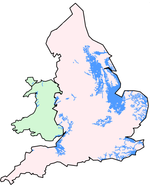
s. The area of an IDB is not determined by county or metropolitan council boundaries, but by water catchment areas within a given region. IDBs are geographically concentrated in the Broads
, Fens in East Anglia
and Lincolnshire
, Somerset Levels
and Yorkshire
. In comparison with public bodies in other countries, IDBs are most similar to the Waterschappen
of the Netherlands
, Consorzi di bonifica e irrigazione of Italy
, wateringen of Flanders and Northern France and watershed district
s of Minnesota
, USA.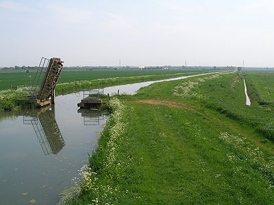
s), ordinary watercourses, pumping stations and other critical infrastructure
, facilitating drainage of new developments, the ecological conservation and enhancement of watercourses, monitoring and advising on planning applications and making sure that any development is carried out in line with legislation (PPS 25
). IDBs are not responsible for watercourses designated as main river
s within their drainage district
s; the supervision of these watercourses is undertaken by the Environment Agency
.
Internal drainage boards date back to 1252; however, the majority of today's IDBs were established by national government
following the passing of the Land Drainage Act 1930 and predominantly operate under the Land Drainage Act 1991 under which, an IDB is required to exercise a general supervision over all matters relating to water level management of land within its district. Some IDBs may also have other duties, powers and responsibilities under specific legislation for the district (for instance the Middle Level Commissioners
are also a navigation authority). IDBs are responsible to Defra from whom all legislation/regulations affecting them are issued. The work of an IDB is closely linked with that of the Environment Agency
which has a range of functions providing a supervisory role over them.
(LGO) from 1 April 2004, and introduced a model complaints procedure for IDBs to operate. This move was aimed to increase the accountability of IDBs to the general public who have an interest in the way that IDBs are run and operate by providing an independent means of review. At this time Defra also revised and re-issued model statutory rules and procedures under which IDBs operate.
in 2010, 154 in England
and 15 in Wales
(2 IDBs cross the border). IDBs cover 1.2 million hectares of England (9.7% of the total land area of the country) and 28,500 hectares of Wales (1.4% of the total land area of the country). Areas around The Wash
, the Lincolnshire
Coast, the lower reaches of the Trent
and the Yorkshire
Ouse
, the Somerset Levels
and the Fens have concentrations of adjacent IDBs. In other parts of the country, especially in Norfolk
and Suffolk
, Sussex
, Kent
, West Yorkshire
, Herefordshire
/Shropshire
and the northern Vale of York
, the majority of IDBs stretch in narrow ‘fingers’ up river valleys, separated by less low lying areas. The largest IDB (Lindsey Marsh DB) covers 52,498 hectares and the smallest (Cawdle Fen IDB) 182 hectares. 24 of the county councils in England include one or more IDB in their area as do six metropolitan districts
, and 109 unitary authorities or district council
s.
The Association of Drainage Authorities
holds a definitive record of all IDBs within England and Wales and their boundaries. On 1 April 2011, a number of IDBs were amalgamated, reducing the number by 11. Two have dropped the designation IDB from their title, one becoming a Water Level Management Board, and the other a Water Management Board, to more accurately reflect their function.
which represents 9.7% of the total land area. Reducing the flood risk to ~600,000 people who live or work, and ~879,000 properties located in IDB districts. Whilst many thousands of people outside of these boundaries also derive reduced flood risk from IDB water level management activities. Several forms of critical infrastructure fall within IDB districts including; 20 oil refineries and power stations, 68 other major industrial premises and 208 km of motorway.
Although of much reduced significance since the 1980s, many IDB districts in Yorkshire
and Nottinghamshire
lie in areas of coal reserves and drainage has been significantly affected by subsidence from mining. IDBs have played an important role in monitoring and mitigating the effects of this activity and have worked in close collaboration with the coal companies and the Coal Authority
.
Accommodating sustainability within the design and maintenance process for lowland rivers and watercourses has to address three essential elements:
Many IDBs are redesigning watercourses to create a two-stage or bermed channel. These have been extensively created in the Lindsey Marsh Drainage Board area of East Lincolnshire
to accommodate the three elements of lowland watercourse sustainability.

Berm
s are created at or near to the normal retained water level in the system. It is sometimes replanted with vegetation removed from the watercourse prior to improvement works but is often left to re-colonise naturally. In all cases this additional part of the channel profile allows for enhanced environmental value to develop. The area created above the berm also provides additional flood storage capacity whilst the low level channel can be maintained in such a manner that design conveyance conditions are achieved and flood risk controlled.
By widening the channel and the berm, the berm can be safely used as access for machinery carrying out channel maintenance. Whilst, in-channel habitat that develops can be retained for a much longer period during the summer months, flood storage is provided for rare or extreme events and a buffer zone between the channel and any adjacent land use is created.
The timing of vegetation clearance works is essential to striking a sustainable balance in lowland watercourses. The Conveyance Estimating System (CES) is a modelling tool developed through a Defra / Environment Agency
research collaboration. IDBs use CES to estimate the seasonal variation of conveyance owing to vegetation growth and other physical parameters which they use to assess the impact of varying the timing of vegetation clearance operations. This is critical during the Spring and early Summer, the prime nesting season for aquatic birds, the breeding season for many protected mammal species such as water voles and the season when many rare species of plant life flower and seed. Many IDBs have developed vegetation control strategies in co-ordination with Natural England
.
some 635722 hectares (2,454.5 sq mi) of land in IDB districts rely on pumping, almost 51% of the total. A new pumping station was commissioned in April 2011 by the Middle Level Commissioners
at Wiggenhall St Germans, Norfolk. The station replaced its 73 year old predecessor and is vital to the flood risk management of 700 km² (270.3 sq mi) of surrounding Fenland and 20,000 residential properties. When running at full capacity, it is capable of draining 5 Olympic size swimming pools every 2 minutes.
An IDB's priorities during flooding are:
Some IDBs are able to provide a 24 hour contact number and most extend office hours during severe emergencies.
. Slow flowing drainage channels such as those managed by IDBs can form an important habitat for a diverse community of aquatic and emergent plants, invertebrates and higher organisms. IDB channels form one of the last refuges in the UK of the BAP
registered spined loach
(Cobitis Taenia), a small nocturnal bottom feeding fish that have been recorded only in the lower parts of the Trent and Great Ouse catchments, and in some small rivers and drains in Lincolnshire and East Anglia. All IDBs are currently engaging with the their own individual biodiversity action plans which will further enhance their environmental role.
Many IDBs are involved with assisting major wetland
biodiversity projects with organisations such as the RSPB, National Trust
and the Wildfowl and Wetlands Trust
. Many smaller conservation projects are co-ordinated with Wildlife Trusts
and Local Authorities. Current projects include: The Great Fen Project
(Middle Level Commissioners), Newport Wetlands Reserve
(Caldicot and Wentlooge Levels IDB) and WWT Welney
(MLC). Middle Level Commissioners launched a three year Otter Recovery Project in December 2007. It will build 33 otter holts and 15 other habitat areas.
are deemed to derive benefit from the activities of an IDB. Every property is therefore subject to a drainage rate paid annually to the IDB.
For the purposes of rating, properties are divided into:
Occupiers of all "other land" pay Council Tax or Non-Domestic Rates to the local authority who then are charged by the board. This charge is called the "Special Levy". The board, therefore, only demands drainage rates direct on agricultural land and buildings. The basis of this is that each property has been allotted an "annual value" which were last revised in the early 1990s. The annual value is an amount equal to the yearly rent, or the rent that might be reasonably expected if let on a tenancy from year to year commencing 1 April 1988. The annual value remains the same from year to year. Each year the board lays a rate "in the £" to meet its estimated expenditure. This is multiplied by the annual value to produce the amount of drainage rate due on each property.
may issue a precept to an IDB to recover a contribution that the Agency considers fair towards their expenses.
Under Section 57 of the Land Drainage Act 1991, in cases where a drainage district
receives water from land at a higher level, the IDB may make an application to the Environment Agency
for a contribution towards the expenses of dealing with that water.
.
(ADA) their representative organisation. Through ADA the collective views of drainage authorities and other members involved in water level management are represented to government, regulators, other policy makers and stakeholders. At a European level ADA represents IDBs through EUWMA.
Operating authority
An operating authority is a body empowered under the Land Drainage Act 1991 or Water Resources Act 1991 to undertake land drainage or flood protection work in England and Wales. Operating authorities include internal drainage boards, the Environment Agency and local authorities....
which is established in areas of special drainage
Drainage
Drainage is the natural or artificial removal of surface and sub-surface water from an area. Many agricultural soils need drainage to improve production or to manage water supplies.-Early history:...
need in England and Wales
England and Wales
England and Wales is a jurisdiction within the United Kingdom. It consists of England and Wales, two of the four countries of the United Kingdom...
with permissive powers to undertake work to secure clean water drainage and water level management within drainage district
Drainage district
Drainage districts occur in England and Wales, varying in size from a few hundred acres to over , all in low lying areas of the country where flood risk management and land drainage are sensitive issues...
s. The area of an IDB is not determined by county or metropolitan council boundaries, but by water catchment areas within a given region. IDBs are geographically concentrated in the Broads
The Broads
The Broads are a network of mostly navigable rivers and lakes in the English counties of Norfolk and Suffolk. The Broads, and some surrounding land were constituted as a special area with a level of protection similar to a UK National Park by The Norfolk and Suffolk Broads Act of 1988...
, Fens in East Anglia
East Anglia
East Anglia is a traditional name for a region of eastern England, named after an ancient Anglo-Saxon kingdom, the Kingdom of the East Angles. The Angles took their name from their homeland Angeln, in northern Germany. East Anglia initially consisted of Norfolk and Suffolk, but upon the marriage of...
and Lincolnshire
Lincolnshire
Lincolnshire is a county in the east of England. It borders Norfolk to the south east, Cambridgeshire to the south, Rutland to the south west, Leicestershire and Nottinghamshire to the west, South Yorkshire to the north west, and the East Riding of Yorkshire to the north. It also borders...
, Somerset Levels
Somerset Levels
The Somerset Levels, or the Somerset Levels and Moors as they are less commonly but more correctly known, is a sparsely populated coastal plain and wetland area of central Somerset, South West England, between the Quantock and Mendip Hills...
and Yorkshire
Yorkshire
Yorkshire is a historic county of northern England and the largest in the United Kingdom. Because of its great size in comparison to other English counties, functions have been increasingly undertaken over time by its subdivisions, which have also been subject to periodic reform...
. In comparison with public bodies in other countries, IDBs are most similar to the Waterschappen
Water board (The Netherlands)
Dutch water boards are regional government bodies charged with managing the water barriers, the waterways, the water levels, water quality and sewage treatment in their respective regions...
of the Netherlands
Netherlands
The Netherlands is a constituent country of the Kingdom of the Netherlands, located mainly in North-West Europe and with several islands in the Caribbean. Mainland Netherlands borders the North Sea to the north and west, Belgium to the south, and Germany to the east, and shares maritime borders...
, Consorzi di bonifica e irrigazione of Italy
Italy
Italy , officially the Italian Republic languages]] under the European Charter for Regional or Minority Languages. In each of these, Italy's official name is as follows:;;;;;;;;), is a unitary parliamentary republic in South-Central Europe. To the north it borders France, Switzerland, Austria and...
, wateringen of Flanders and Northern France and watershed district
Watershed district
Watershed districts are special government entities in the U.S. state of Minnesota that monitor and regulate the use of water in watersheds surrounding various lakes and rivers in the state. The districts cover the natural regions of the watersheds, rather than politically-defined regions...
s of Minnesota
Minnesota
Minnesota is a U.S. state located in the Midwestern United States. The twelfth largest state of the U.S., it is the twenty-first most populous, with 5.3 million residents. Minnesota was carved out of the eastern half of the Minnesota Territory and admitted to the Union as the thirty-second state...
, USA.
Responsibilities
Much of their work involves the maintenance of rivers, drainage channels (rhyneRhyne
A rhyne , rhine/rhyne , or reen is a drainage ditch, or canal, used to turn areas of wetland at around sea level into useful pasture....
s), ordinary watercourses, pumping stations and other critical infrastructure
Critical infrastructure
Critical infrastructure is a term used by governments to describe assets that are essential for the functioning of a society and economy. Most commonly associated with the term are facilities for:*electricity generation, transmission and distribution;...
, facilitating drainage of new developments, the ecological conservation and enhancement of watercourses, monitoring and advising on planning applications and making sure that any development is carried out in line with legislation (PPS 25
PPS 25
Planning Policy Statement 25, commonly abbreviated as PPS 25, is a document produced by the British Government and intended to set out policy on development and flood risk. PPS25 was published in December 2006 and has been supplemented with a Practice Guide in June 2008...
). IDBs are not responsible for watercourses designated as main river
Main river
Main rivers are a statutory type of watercourse in England and Wales, usually larger streams and rivers, but also include some smaller watercourses. A main river is defined as a watercourse marked as such on a main river map, and can include any structure or appliance for controlling or regulating...
s within their drainage district
Drainage district
Drainage districts occur in England and Wales, varying in size from a few hundred acres to over , all in low lying areas of the country where flood risk management and land drainage are sensitive issues...
s; the supervision of these watercourses is undertaken by the Environment Agency
Environment Agency
The Environment Agency is a British non-departmental public body of the Department for Environment, Food and Rural Affairs and an Assembly Government Sponsored Body of the Welsh Assembly Government that serves England and Wales.-Purpose:...
.
Internal drainage boards date back to 1252; however, the majority of today's IDBs were established by national government
Central government
A central government also known as a national government, union government and in federal states, the federal government, is the government at the level of the nation-state. The structure of central governments varies from institution to institution...
following the passing of the Land Drainage Act 1930 and predominantly operate under the Land Drainage Act 1991 under which, an IDB is required to exercise a general supervision over all matters relating to water level management of land within its district. Some IDBs may also have other duties, powers and responsibilities under specific legislation for the district (for instance the Middle Level Commissioners
Middle Level Commissioners
The Middle Level Commissioners are a land drainage authority in eastern England. The body was formed in 1862, undertaking the main water level management function within the Middle Level following the breakup of the former Bedford Level Corporation....
are also a navigation authority). IDBs are responsible to Defra from whom all legislation/regulations affecting them are issued. The work of an IDB is closely linked with that of the Environment Agency
Environment Agency
The Environment Agency is a British non-departmental public body of the Department for Environment, Food and Rural Affairs and an Assembly Government Sponsored Body of the Welsh Assembly Government that serves England and Wales.-Purpose:...
which has a range of functions providing a supervisory role over them.
Regulation
Defra brought IDBs under the jurisdiction of the Local Government OmbudsmanLocal Government Ombudsman
A Local Government Ombudsman is an official employed by the Commission for Local Administration in England , a body of commissioners established under the Local Government Act 1974 to investigate complaints about councils and certain other bodies in England. Each of three Local Government Ombudsmen...
(LGO) from 1 April 2004, and introduced a model complaints procedure for IDBs to operate. This move was aimed to increase the accountability of IDBs to the general public who have an interest in the way that IDBs are run and operate by providing an independent means of review. At this time Defra also revised and re-issued model statutory rules and procedures under which IDBs operate.
Current internal drainage boards of England and Wales
There were 177 internal drainage boards in the Great BritainGreat Britain
Great Britain or Britain is an island situated to the northwest of Continental Europe. It is the ninth largest island in the world, and the largest European island, as well as the largest of the British Isles...
in 2010, 154 in England
England
England is a country that is part of the United Kingdom. It shares land borders with Scotland to the north and Wales to the west; the Irish Sea is to the north west, the Celtic Sea to the south west, with the North Sea to the east and the English Channel to the south separating it from continental...
and 15 in Wales
Wales
Wales is a country that is part of the United Kingdom and the island of Great Britain, bordered by England to its east and the Atlantic Ocean and Irish Sea to its west. It has a population of three million, and a total area of 20,779 km²...
(2 IDBs cross the border). IDBs cover 1.2 million hectares of England (9.7% of the total land area of the country) and 28,500 hectares of Wales (1.4% of the total land area of the country). Areas around The Wash
The Wash
The Wash is the square-mouthed bay and estuary on the northwest margin of East Anglia on the east coast of England, where Norfolk meets Lincolnshire. It is among the largest estuaries in the United Kingdom...
, the Lincolnshire
Lincolnshire
Lincolnshire is a county in the east of England. It borders Norfolk to the south east, Cambridgeshire to the south, Rutland to the south west, Leicestershire and Nottinghamshire to the west, South Yorkshire to the north west, and the East Riding of Yorkshire to the north. It also borders...
Coast, the lower reaches of the Trent
River Trent
The River Trent is one of the major rivers of England. Its source is in Staffordshire on the southern edge of Biddulph Moor. It flows through the Midlands until it joins the River Ouse at Trent Falls to form the Humber Estuary, which empties into the North Sea below Hull and Immingham.The Trent...
and the Yorkshire
Yorkshire
Yorkshire is a historic county of northern England and the largest in the United Kingdom. Because of its great size in comparison to other English counties, functions have been increasingly undertaken over time by its subdivisions, which have also been subject to periodic reform...
Ouse
River Ouse, Yorkshire
The River Ouse is a river in North Yorkshire, England. The river is formed from the River Ure at Cuddy Shaw Reach near Linton-on-Ouse, about 6 miles downstream of the confluence of the River Swale with the River Ure...
, the Somerset Levels
Somerset Levels
The Somerset Levels, or the Somerset Levels and Moors as they are less commonly but more correctly known, is a sparsely populated coastal plain and wetland area of central Somerset, South West England, between the Quantock and Mendip Hills...
and the Fens have concentrations of adjacent IDBs. In other parts of the country, especially in Norfolk
Norfolk
Norfolk is a low-lying county in the East of England. It has borders with Lincolnshire to the west, Cambridgeshire to the west and southwest and Suffolk to the south. Its northern and eastern boundaries are the North Sea coast and to the north-west the county is bordered by The Wash. The county...
and Suffolk
Suffolk
Suffolk is a non-metropolitan county of historic origin in East Anglia, England. It has borders with Norfolk to the north, Cambridgeshire to the west and Essex to the south. The North Sea lies to the east...
, Sussex
Sussex
Sussex , from the Old English Sūþsēaxe , is an historic county in South East England corresponding roughly in area to the ancient Kingdom of Sussex. It is bounded on the north by Surrey, east by Kent, south by the English Channel, and west by Hampshire, and is divided for local government into West...
, Kent
Kent
Kent is a county in southeast England, and is one of the home counties. It borders East Sussex, Surrey and Greater London and has a defined boundary with Essex in the middle of the Thames Estuary. The ceremonial county boundaries of Kent include the shire county of Kent and the unitary borough of...
, West Yorkshire
West Yorkshire
West Yorkshire is a metropolitan county within the Yorkshire and the Humber region of England with a population of 2.2 million. West Yorkshire came into existence as a metropolitan county in 1974 after the passage of the Local Government Act 1972....
, Herefordshire
Herefordshire
Herefordshire is a historic and ceremonial county in the West Midlands region of England. For Eurostat purposes it is a NUTS 3 region and is one of three counties that comprise the "Herefordshire, Worcestershire and Gloucestershire" NUTS 2 region. It also forms a unitary district known as the...
/Shropshire
Shropshire
Shropshire is a county in the West Midlands region of England. For Eurostat purposes, the county is a NUTS 3 region and is one of four counties or unitary districts that comprise the "Shropshire and Staffordshire" NUTS 2 region. It borders Wales to the west...
and the northern Vale of York
Vale of York
The Vale of York is an area of flat land in the north-east of England. The vale is a major agricultural area and serves as the main north-south transport corridor for northern England....
, the majority of IDBs stretch in narrow ‘fingers’ up river valleys, separated by less low lying areas. The largest IDB (Lindsey Marsh DB) covers 52,498 hectares and the smallest (Cawdle Fen IDB) 182 hectares. 24 of the county councils in England include one or more IDB in their area as do six metropolitan districts
Metropolitan borough
A metropolitan borough is a type of local government district in England, and is a subdivision of a metropolitan county. Created in 1974 by the Local Government Act 1972, metropolitan boroughs are defined in English law as metropolitan districts, however all of them have been granted or regranted...
, and 109 unitary authorities or district council
Non-metropolitan district
Non-metropolitan districts, or colloquially shire districts, are a type of local government district in England. As created, they are sub-divisions of non-metropolitan counties in a so-called "two-tier" arrangement...
s.
The Association of Drainage Authorities
Association of Drainage Authorities
The Association of Drainage Authorities is a membership body for organisations involved in water level management within the United Kingdom.-Membership:The Association's members are* Internal drainage boards...
holds a definitive record of all IDBs within England and Wales and their boundaries. On 1 April 2011, a number of IDBs were amalgamated, reducing the number by 11. Two have dropped the designation IDB from their title, one becoming a Water Level Management Board, and the other a Water Management Board, to more accurately reflect their function.
| Internal Drainage Boards of England and Wales | |||
 | |||
Internal Drainage Boards of England
|
|
| Internal Drainage Boards of Wales
Key to abbreviations IDB = Internal Drainage Board DB = Drainage Board IDD = Internal Drainage District DDC = District Drainage Commissioners DC = Drainage Commissioners C of S = Commissioners of Sewers WLMB = Water Level Management Board WMB = Water Management Board |
Water level management and flood risk
IDBs have an important role in reducing flood risk through management of water levels and drainage in their districts. The water level management activities of internal drainage boards cover 1.2 million hectares of EnglandEngland
England is a country that is part of the United Kingdom. It shares land borders with Scotland to the north and Wales to the west; the Irish Sea is to the north west, the Celtic Sea to the south west, with the North Sea to the east and the English Channel to the south separating it from continental...
which represents 9.7% of the total land area. Reducing the flood risk to ~600,000 people who live or work, and ~879,000 properties located in IDB districts. Whilst many thousands of people outside of these boundaries also derive reduced flood risk from IDB water level management activities. Several forms of critical infrastructure fall within IDB districts including; 20 oil refineries and power stations, 68 other major industrial premises and 208 km of motorway.
Although of much reduced significance since the 1980s, many IDB districts in Yorkshire
Yorkshire
Yorkshire is a historic county of northern England and the largest in the United Kingdom. Because of its great size in comparison to other English counties, functions have been increasingly undertaken over time by its subdivisions, which have also been subject to periodic reform...
and Nottinghamshire
Nottinghamshire
Nottinghamshire is a county in the East Midlands of England, bordering South Yorkshire to the north-west, Lincolnshire to the east, Leicestershire to the south, and Derbyshire to the west...
lie in areas of coal reserves and drainage has been significantly affected by subsidence from mining. IDBs have played an important role in monitoring and mitigating the effects of this activity and have worked in close collaboration with the coal companies and the Coal Authority
Coal Authority
The Coal Authority is a non-departmental public body of the United Kingdom government.-History:It was established under the Coal Industry Act 1994 to manage certain functions previously undertaken by the British Coal Corporation , including ownership of unworked coal.It is situated in the south of...
.
Maintenance of watercourses
The fundamental role of an internal drainage board is to manage the water level within its district. The majority of lowland rivers and watercourses have been heavily modified by man or are totally artificial channels. All are engineered structures designed and constructed for the primary function of conveying surplus run-off to their outfall efficiently and safely, managing water levels to sustain a multitude of land functions. As with any engineered structure it must be maintained in order to function at or near its design capacity. Annual or bi-annual vegetation clearance and periodic de-silting (dredging) of these rivers and watercourses is therefore an essential component of the whole life cycle of these watercourses.Accommodating sustainability within the design and maintenance process for lowland rivers and watercourses has to address three essential elements:
- year round conveyance of flows,
- storage of flood peaks,
- retention and protection of flora and fauna dependent on or resident in the water corridor.
Many IDBs are redesigning watercourses to create a two-stage or bermed channel. These have been extensively created in the Lindsey Marsh Drainage Board area of East Lincolnshire
Lincolnshire
Lincolnshire is a county in the east of England. It borders Norfolk to the south east, Cambridgeshire to the south, Rutland to the south west, Leicestershire and Nottinghamshire to the west, South Yorkshire to the north west, and the East Riding of Yorkshire to the north. It also borders...
to accommodate the three elements of lowland watercourse sustainability.
Berm
Berm
A berm is a level space, shelf, or raised barrier separating two areas. Berm originates in the Middle Dutch and German berme and came into usage in English via French.- History :...
s are created at or near to the normal retained water level in the system. It is sometimes replanted with vegetation removed from the watercourse prior to improvement works but is often left to re-colonise naturally. In all cases this additional part of the channel profile allows for enhanced environmental value to develop. The area created above the berm also provides additional flood storage capacity whilst the low level channel can be maintained in such a manner that design conveyance conditions are achieved and flood risk controlled.
By widening the channel and the berm, the berm can be safely used as access for machinery carrying out channel maintenance. Whilst, in-channel habitat that develops can be retained for a much longer period during the summer months, flood storage is provided for rare or extreme events and a buffer zone between the channel and any adjacent land use is created.
The timing of vegetation clearance works is essential to striking a sustainable balance in lowland watercourses. The Conveyance Estimating System (CES) is a modelling tool developed through a Defra / Environment Agency
Environment Agency
The Environment Agency is a British non-departmental public body of the Department for Environment, Food and Rural Affairs and an Assembly Government Sponsored Body of the Welsh Assembly Government that serves England and Wales.-Purpose:...
research collaboration. IDBs use CES to estimate the seasonal variation of conveyance owing to vegetation growth and other physical parameters which they use to assess the impact of varying the timing of vegetation clearance operations. This is critical during the Spring and early Summer, the prime nesting season for aquatic birds, the breeding season for many protected mammal species such as water voles and the season when many rare species of plant life flower and seed. Many IDBs have developed vegetation control strategies in co-ordination with Natural England
Natural England
Natural England is the non-departmental public body of the UK government responsible for ensuring that England's natural environment, including its land, flora and fauna, freshwater and marine environments, geology and soils, are protected and improved...
.
Pumping stations
111 IDB districts require pumping to some degree for water level management and 79 are purely gravity boards (where no pumping is required). 53 IDBs have more than 95% of their area dependent on pumping. This means in EnglandEngland
England is a country that is part of the United Kingdom. It shares land borders with Scotland to the north and Wales to the west; the Irish Sea is to the north west, the Celtic Sea to the south west, with the North Sea to the east and the English Channel to the south separating it from continental...
some 635722 hectares (2,454.5 sq mi) of land in IDB districts rely on pumping, almost 51% of the total. A new pumping station was commissioned in April 2011 by the Middle Level Commissioners
Middle Level Commissioners
The Middle Level Commissioners are a land drainage authority in eastern England. The body was formed in 1862, undertaking the main water level management function within the Middle Level following the breakup of the former Bedford Level Corporation....
at Wiggenhall St Germans, Norfolk. The station replaced its 73 year old predecessor and is vital to the flood risk management of 700 km² (270.3 sq mi) of surrounding Fenland and 20,000 residential properties. When running at full capacity, it is capable of draining 5 Olympic size swimming pools every 2 minutes.
Emergency actions
During times of heavy rainfall and high river levels IDBs:- liaise with the Environment Agency over developing flood conditions
- check sensitive locations and remove restrictions
- take actions, where possible, to reduce risk of flooding to property
- advise local authorities on the developing situation in order that Local Authorities can execute their emergency
- plan effectively for the protection of people, property and critical infrastructure
- assist where possible in any post-flood remedial and clearance operations
- assess flooding incidents to determine if new works can be undertaken to reduce the effect of future flooding incidents
An IDB's priorities during flooding are:
- ensuring the board’s systems are working efficiently
- protection of people and residential properties
- protection of commercial properties
- protection of agricultural land and ecologically sensitive sites
Some IDBs are able to provide a 24 hour contact number and most extend office hours during severe emergencies.
Planning guidance
Associated with the powers to regulate activities that may impede drainage, IDBs provide comments to local planning authorities on developments in their district and when asked, make recommendations on measures required to manage flood risk and to provide adequate drainage.Environmental responsibilities
Internal drainage boards in England have responsibilities associated with 398 Sites of Special Scientific Interest plus other designated environmental areas, in co-ordination with Natural EnglandNatural England
Natural England is the non-departmental public body of the UK government responsible for ensuring that England's natural environment, including its land, flora and fauna, freshwater and marine environments, geology and soils, are protected and improved...
. Slow flowing drainage channels such as those managed by IDBs can form an important habitat for a diverse community of aquatic and emergent plants, invertebrates and higher organisms. IDB channels form one of the last refuges in the UK of the BAP
Biodiversity Action Plan
A Biodiversity Action Plan is an internationally recognized program addressing threatened species and habitats and is designed to protect and restore biological systems. The original impetus for these plans derives from the 1992 Convention on Biological Diversity...
registered spined loach
Spined Loach
The Spined Loach is a common freshwater fish in Europe and Asia. It is sometimes known as spotted weather loach, not to be confused with the "typical" weather loaches of the genus Misgurnus...
(Cobitis Taenia), a small nocturnal bottom feeding fish that have been recorded only in the lower parts of the Trent and Great Ouse catchments, and in some small rivers and drains in Lincolnshire and East Anglia. All IDBs are currently engaging with the their own individual biodiversity action plans which will further enhance their environmental role.
Many IDBs are involved with assisting major wetland
Wetland
A wetland is an area of land whose soil is saturated with water either permanently or seasonally. Wetlands are categorised by their characteristic vegetation, which is adapted to these unique soil conditions....
biodiversity projects with organisations such as the RSPB, National Trust
National Trust for Places of Historic Interest or Natural Beauty
The National Trust for Places of Historic Interest or Natural Beauty, usually known as the National Trust, is a conservation organisation in England, Wales and Northern Ireland...
and the Wildfowl and Wetlands Trust
Wildfowl and Wetlands Trust
The Wildfowl & Wetlands Trust is a wildfowl and wetland conservation charity in the United Kingdom. Its patron is Queen Elizabeth II.It was founded in 1946 by the ornithologist and artist Sir Peter Scott, initially as the Severn Wildfowl Trust...
. Many smaller conservation projects are co-ordinated with Wildlife Trusts
The Wildlife Trusts partnership
The Wildlife Trusts is an organisation made up of 47 local Wildlife Trusts in the United Kingdom plus the Isle of Man and Alderney.The Wildlife Trusts, between them, look after around 2,300 nature reserves covering more than 90,000 hectares...
and Local Authorities. Current projects include: The Great Fen Project
The Great Fen Project
The Great Fen Project is a habitat restoration project being undertaken on The Fens in the county of Cambridgeshire in the United Kingdom. It is one of the largest restoration projects in the country, and aims to create a 3,700 hectare wetland and will connect Woodwalton Fen National Nature Reserve...
(Middle Level Commissioners), Newport Wetlands Reserve
Newport Wetlands Reserve
Newport Wetlands Reserve is a wildlife reserve between Uskmouth, Nash and Goldcliff, in the south-east of the city of Newport, South Wales.- History :...
(Caldicot and Wentlooge Levels IDB) and WWT Welney
Ouse Washes
The Ouse Washes are an area in the Fens of Cambridgeshire and Norfolk, England. They cover the area between two diversion channels of the River Great Ouse: the Old Bedford River and the New Bedford River .-History:...
(MLC). Middle Level Commissioners launched a three year Otter Recovery Project in December 2007. It will build 33 otter holts and 15 other habitat areas.
Drainage rates
All properties within a drainage districtDrainage district
Drainage districts occur in England and Wales, varying in size from a few hundred acres to over , all in low lying areas of the country where flood risk management and land drainage are sensitive issues...
are deemed to derive benefit from the activities of an IDB. Every property is therefore subject to a drainage rate paid annually to the IDB.
For the purposes of rating, properties are divided into:
- Agricultural land and buildings
- Other land (such as domestic houses, factories, shops etc)
Occupiers of all "other land" pay Council Tax or Non-Domestic Rates to the local authority who then are charged by the board. This charge is called the "Special Levy". The board, therefore, only demands drainage rates direct on agricultural land and buildings. The basis of this is that each property has been allotted an "annual value" which were last revised in the early 1990s. The annual value is an amount equal to the yearly rent, or the rent that might be reasonably expected if let on a tenancy from year to year commencing 1 April 1988. The annual value remains the same from year to year. Each year the board lays a rate "in the £" to meet its estimated expenditure. This is multiplied by the annual value to produce the amount of drainage rate due on each property.
Precepts
Under Section 141 of the Water Resources Act 1991 the Environment AgencyEnvironment Agency
The Environment Agency is a British non-departmental public body of the Department for Environment, Food and Rural Affairs and an Assembly Government Sponsored Body of the Welsh Assembly Government that serves England and Wales.-Purpose:...
may issue a precept to an IDB to recover a contribution that the Agency considers fair towards their expenses.
Under Section 57 of the Land Drainage Act 1991, in cases where a drainage district
Drainage district
Drainage districts occur in England and Wales, varying in size from a few hundred acres to over , all in low lying areas of the country where flood risk management and land drainage are sensitive issues...
receives water from land at a higher level, the IDB may make an application to the Environment Agency
Environment Agency
The Environment Agency is a British non-departmental public body of the Department for Environment, Food and Rural Affairs and an Assembly Government Sponsored Body of the Welsh Assembly Government that serves England and Wales.-Purpose:...
for a contribution towards the expenses of dealing with that water.
District drainage commissioners
District drainage commissioners (DDCs) are internal drainage boards set up under local legislation rather than the Land Drainage Act 1991 and its predecessor legislation. The majority of the provisions of the Land Drainage Acts, do however, apply to such commissioners and they are statutory public bodies. The most important in terms of size and revenue is the Middle Level CommissionersMiddle Level Commissioners
The Middle Level Commissioners are a land drainage authority in eastern England. The body was formed in 1862, undertaking the main water level management function within the Middle Level following the breakup of the former Bedford Level Corporation....
.
Association of Drainage Authorities
The majority of internal drainage boards are members of the Association of Drainage AuthoritiesAssociation of Drainage Authorities
The Association of Drainage Authorities is a membership body for organisations involved in water level management within the United Kingdom.-Membership:The Association's members are* Internal drainage boards...
(ADA) their representative organisation. Through ADA the collective views of drainage authorities and other members involved in water level management are represented to government, regulators, other policy makers and stakeholders. At a European level ADA represents IDBs through EUWMA.
External links
- Association of Drainage Authorities
- Defra Flood and Coastal Risk Management
- European Union of Water Management Associations
Internal drainage board websites
- Bedford Group of Drainage Boards
- Black Sluice Internal Drainage Board
- Caldicot and Wentlooge Levels Internal Drainage Board
- Downham Market Group of Internal Drainage Boards
- Ely Group of Internal Drainage Boards
- Lower Aire & Don Consortia of Drainage Boards
- Lower Ouse Internal Drainage Board
- Lower Severn Internal Drainage Board
- Lindsey Marsh Drainage Board
- Market Weighton Internal Drainage Board
- Medway Internal Drainage Boards
- Middle Level Commissioners
- Newark Area Internal Drainage Board
- North East Lindsey Internal Drainage Board
- North Level District Internal Drainage Board
- River Stour (Kent) Internal Drainage Board
- Romney Marsh Area Internal Drainage Board
- Shire Group of Internal Drainage Boards
- Somerset Drainage Boards Consortium
- Vale of Pickering Internal Drainage Boards
- Upper Witham Internal Drainage Board
- Water Management Alliance
- Welland and Deepings Internal Drainage Board
- West Mendip Internal Drainage Board
- Whittlesey Consortium of Internal Drainage Boards
- Witham First District Internal Drainage Board
- Witham Third District Internal Drainage Board
- Witham 4th District Internal Drainage Board
- York Consortium of Drainage Boards