
Hatfield Chase
Encyclopedia
Hatfield Chase was a low-lying area in South Yorkshire
, England
which often flooded and is chiefly known from the Battle of Hatfield Chase
in 633. It was a royal hunting ground until Charles I
appointed the Dutch engineer Cornelius Vermuyden
to drain it in 1626. This changed the whole nature of a wide swathe of land including the Isle of Axholme
and caused legal disputes for the rest of the century.
 Hatfield Chase lay above the confluence of three rivers, the Don, the Torne
and the Idle
, which meandered into the Trent
near its entrance to the Humber. The whole of this area, apart from the Isle of Axholme, is less than 10 feet (3 m) above sea level and was therefore subject to frequent flooding. Although the area included some common land it was unlawful to take fish or game though many locals gained their livelihood by fishing and fowling
the area which was unsuitable for agriculture.
The circumstances of Charles' appointment of Vermuyden to drain this area in 1626 are obscure. A story that he had accompanied an earlier royal hunting party is almost certainly fictional.
But the king was keen to make his assets profitable and the contract divided the land into three parts, one for the king, one for the adventurers who would drain the land and the remainder for those locals who had interests in the land.
Vermuyden brought over a number of Walloon
partners, known as the Participants, who took shares and performed the drainage work, including a number of Huguenot
families fleeing from religious persecution who settled at Sandtoft. The work was substantially completed by 1628 at a cost of £400,000.
The eastern branch of the Don river was blocked and the banks of the northern branch into the River Aire
were raised. The northern branch was originally a Roman navigation channel called Turnbridgedike. A 2 miles (3.2 km) bank which ran along the south side of the river from Fishlake to Thorne included a navigable sluice, to allow boats to reach Sandtoft. Lifting gates gave access to a lock chamber which was 50 by. Beyond Thorne, a further bank ran for 5 miles (8 km) to the Aire. The River Idle was blocked by a dam and its waters were diverted into the River Trent at Stockwith
along Bycarrs Dyke. A 5 miles (8 km) barrier bank was constructed along the northern edge of the channel, from the dam to the River Trent. The Torne was embanked and straightened by cutting a drain which emptied via a sluice
into the Trent at Althorpe
. An 8 miles (12.9 km) drain was cut from where the Idle had been blocked to Dirtness, passing under the Torne at Tunnel Pits. At Dirtness it was joined by another drain, bringing water from the west, and then ran for a further 5 miles (8 km) to another sluice at Althorpe. The work was on a scale not previously seen in England, and Vermuyden's contribution was recognised when he was knighted in January 1629. In 1629, a Court of Sewers for the Level of Hatfield Chase was established by Royal Warrant.
The drainage transformed the whole area, creating rich agricultural land where there had previously been swamps though it was still subject to periodic flooding.
Many local people were not very happy with the outcome. Those entitled to common rights, mainly from the Isle of Axholme, claimed they had been allotted the worst land. There were complaints of flooding from those further down the Don in the villages of Fishlake, Sykehouse
and Snaith
. Recrimination against foreign settlers was encouraged by those who had lost their fishing and other livelihood.
The flooding of Fishlake and Sykehouse resulted from there being insufficient washlands to hold the flow of the Don while the sluice at Turnbridgedike was closed by high water levels in the Aire. A navigable sluice was constructed at Turnbridgedike, including a lock chamber which was 60 by and 17 discharge gates, each 6 by. The structure was probably built by Hugo Spiering, who assisted Vermuyden, and was called the Great Sluice. This still did not fully alleviate the problems of flooding, and so a new 5 miles (8 km) embanked channel was constructed from Newbridge to the River Ouse
at Goole
between 1632 and 1635. The river levels at Goole were some 5 to 10 ft (1.5 to 3 m) lower than at Turnbridgedike, and so discharge was more efficient. The total cost of the channel and outfall sluice was £33,000. There was no navigable connection to the Ouse at Goole, as boats continued to access the Aire at Turnbridgedike. The channel eventually became the wide Dutch River after two drains were swept into one following a great flood.
After various lawsuits and petitions, locals took action during the confusion of the Civil War
and flooded Hatfield Chase by raising floodgates and damaging banks and sluices. Riots broke out when the courts finally ruled against them in 1650. Peace was restored, but lawsuits continued for the rest of the century and were not finally resolved until 1719.
was asked to make an assessment. He produced reports in September 1764 and October 1776, which formed the basis for remedial work. This was carried out in stages from 1776 until it was completed in 1789.
Improvements continued in the early 19th century, authorised by several Acts of Parliament
. The Hatfield Chase Drainage Act of 1813 created two commissioners, who had powers to raise £15,000, to be used for construction work specified by the act, which would be adopted by the Court of Sewers once it was completed. The money was raised by additional taxation on those who benefitted from the works. There was also a special engine-rate, which was used to finance the operation of a steam pumping engine in the southern part of the chase. The steam engine was sited at Little Hirst in 1848, but experience showed that it needed to be nearer to the drainage district, and so it was moved to Bull Hassocks in 1858. A second-hand 40 hp engine drove a 30 feet (9.1 m) scoop wheel
.
With a view to improving the drainage of the Chase, an Act of Parliament obtained in 1862 created the Corporation of the Level of Hatfield Chase, which took over the management of the drainage from the individual Participants who had formerly been responsible for it. This act authorised further construction work, including a steam pumping engine for the northern part of the Chase. The areas which were subject to taxation were extended, and the act listed 21 townships and parishes which would be required to pay for the drainage works. The jurisdiction of the Court of Sewers was replaced by the meetings of the Corporation from 1862. The Corporation spent £8,887 on a new pumping station at Dirtness which was operational by 1865. The building contained two compound beam engines, driving a single scoop wheel which was 33.25 by and weighed 80 tons. Bull Hassocks pumping station was upgraded in 1892. Two 48 inch centrifugal pumps were driven by 175 hp steam engines, and when both were running, the station could discharge 300 tons per minute (440 Megalitres per day (Mld)) into the South Engine Drain. Diesel engines gave way to electric pumps at Dirtness in 1928, when they were replaced by a Gwynnes pump driven by an electric motor.
The Land Drainage Act of 1930 changed the administrative bodies responsible for drainage, and the Corporation effectively became an Internal Drainage Board
. In 1941, the Corporation ceased to be, and its powers and responsibilities were split between the Trent River Catchment Board and the River Ouse (Yorkshire) Catchment Board. Despite this change, the management of the area continued much as before, with official records stating that the Catchment Board acted as the Corporation of the Level of Hatfield Chase, even though it no longer existed legally. This continued with the renaming of the Trent River Catchment Board to the Trent River Board, and then the Trent River Authority, which finally became part of the Severn Trent
Water Authority in 1974. In an unusual move, the Corporation of the Level of Hatfield Chase was re-constituted in 1987, by an order of the Ministry of Agriculture, Fisheries and Food
. The order cited the powers of the 1813 and 1862 Acts, and transferred the property and responsibilities for drainage of the area from Severn Trent to the Corporation.
Upgrading of the pumping stations continued. The steam engines at Bull Hassocks were replaced by a single Ruston 300 hp diesel engine with a 36 inches (91.4 cm) Gwynnes pump in 1940, to be supplemented by two more similar units in 1941. By 1988 two electric pumps had been installed, and the station could discharge 330 tons per minute (485 Mld). At Dirtness, the single electric pump was supplemented by two more in 1951, rated at 105 bhp and each capable of moving 110 tons per minute (161 Mld).
. They are responsible for the drainage of an area of 30.8 square miles (79.8 km²), and the maintenance of 84.5 miles (136 km) of watercourses, which includes the operation of nine pumping stations. In addition, the Environment Agency
maintain and operate several pumping stations within the area where the water is pumped into high level carriers, which consist of embanked waterways where the water level is generally above that of the surrounding land.
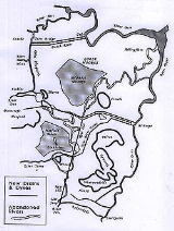
The River Torne, which rises to the west of Tickhill
, crosses the middle of the area. Candy Farm North and South pumping stations are situated on the area's western edge. The South Engine Drain and Folly Drain form the eastern boundary, and run parallel to the River Torne after it has crossed the Chase. Bull Hassocks pumping station is located at the start of the South Engine Drain, and is on the site of the first steam powered pumping station. Hatfield Waste Drain and the North Engine Drain run along the northern boundary. Tunnel Pits North and South pumping stations are located on the Hatfield Waste Drain, while Dirtness pumping station is at the head of the North Engine Drain. The buildings here were erected in 1862. All of these watercourses converge on Pilfrey Junction, from where three parallel channels, called Three Rivers, flow to a pumping station at Keadby
. The Hatfield Waste Drain crosses under the North Engine Drain before the junction, and then becomes the north channel. The centre channel is formed by the North Engine Drain and the River Torne, while the south channel carries the waters of the South Engine Drain and the Folly Drain.
The pumping station at Keadby is equipped with six concrete culverts and six pumps. It was built in 1940, when six Crossley diesel engines, rated at 420 hp and driving 60 inches (152.4 cm) Gwynnes pumps were installed. Five were refurbished by the National Rivers Authority in 1994, and the sixth was replaced by an electric motor. Discharge into the River Trent is through the culverts when the water level in the river is low enough, and through the pumps when it is not. A number of the pumping stations within the Chase are reversible, so that water is pumped from the drainage ditches to the high level carriers when there is a risk of flooding, and from the carriers to the ditches when water is needed for irrigation. The Environment Agency also have pumping stations at Belton Grange, Goodcop and Low Bank, which pump into the Hatfield Waste Drain.
South Yorkshire
South Yorkshire is a metropolitan county in the Yorkshire and the Humber region of England. It has a population of 1.29 million. It consists of four metropolitan boroughs: Barnsley, Doncaster, Rotherham, and City of Sheffield...
, England
England
England is a country that is part of the United Kingdom. It shares land borders with Scotland to the north and Wales to the west; the Irish Sea is to the north west, the Celtic Sea to the south west, with the North Sea to the east and the English Channel to the south separating it from continental...
which often flooded and is chiefly known from the Battle of Hatfield Chase
Battle of Hatfield Chase
The Battle of Hatfield Chase was fought on October 12, 633 at Hatfield Chase near Doncaster, Yorkshire, in Anglo-Saxon England between the Northumbrians under Edwin and an alliance of the Welsh of Gwynedd under Cadwallon ap Cadfan and the Mercians under Penda. The site was a marshy area about 8...
in 633. It was a royal hunting ground until Charles I
Charles I of England
Charles I was King of England, King of Scotland, and King of Ireland from 27 March 1625 until his execution in 1649. Charles engaged in a struggle for power with the Parliament of England, attempting to obtain royal revenue whilst Parliament sought to curb his Royal prerogative which Charles...
appointed the Dutch engineer Cornelius Vermuyden
Cornelius Vermuyden
Sir Cornelius Wasterdyk Vermuyden was a Dutch engineer who introduced Dutch reclamation methods to Britain, and made the first important attempts to drain The Fens of East Anglia.-Life:...
to drain it in 1626. This changed the whole nature of a wide swathe of land including the Isle of Axholme
Isle of Axholme
The Isle of Axholme is part of North Lincolnshire, England. It is the only part of Lincolnshire west of the River Trent. It is between the three towns of Doncaster, Scunthorpe and Gainsborough.- Description:...
and caused legal disputes for the rest of the century.
History of the Drainage
River Torne
The River Torne is a river in the north of England, which flows through the counties of South Yorkshire and North Lincolnshire. It rises at the Upper Lake at Sandbeck Hall, near Maltby in South Yorkshire, and empties into the River Trent at Keadby pumping station...
and the Idle
River Idle
The River Idle is a river in Nottinghamshire, England. Its source is the confluence of the River Maun and River Meden, near Markham Moor. From there, it flows north through Retford and Bawtry before entering the River Trent at Stockwith near Misterton...
, which meandered into the Trent
River Trent
The River Trent is one of the major rivers of England. Its source is in Staffordshire on the southern edge of Biddulph Moor. It flows through the Midlands until it joins the River Ouse at Trent Falls to form the Humber Estuary, which empties into the North Sea below Hull and Immingham.The Trent...
near its entrance to the Humber. The whole of this area, apart from the Isle of Axholme, is less than 10 feet (3 m) above sea level and was therefore subject to frequent flooding. Although the area included some common land it was unlawful to take fish or game though many locals gained their livelihood by fishing and fowling
Fowling
Fowling is a term which is perhaps better known in the Fens of eastern England than elsewhere. It was more than the commercial equivalent of the field sport of wildfowling, in that it includes all forms of bird catching for meat, feathers or any other part of the bird which may have been sold on...
the area which was unsuitable for agriculture.
The circumstances of Charles' appointment of Vermuyden to drain this area in 1626 are obscure. A story that he had accompanied an earlier royal hunting party is almost certainly fictional.
But the king was keen to make his assets profitable and the contract divided the land into three parts, one for the king, one for the adventurers who would drain the land and the remainder for those locals who had interests in the land.
Vermuyden brought over a number of Walloon
Walloons
Walloons are a French-speaking people who live in Belgium, principally in Wallonia. Walloons are a distinctive community within Belgium, important historical and anthropological criteria bind Walloons to the French people. More generally, the term also refers to the inhabitants of the Walloon...
partners, known as the Participants, who took shares and performed the drainage work, including a number of Huguenot
Huguenot
The Huguenots were members of the Protestant Reformed Church of France during the 16th and 17th centuries. Since the 17th century, people who formerly would have been called Huguenots have instead simply been called French Protestants, a title suggested by their German co-religionists, the...
families fleeing from religious persecution who settled at Sandtoft. The work was substantially completed by 1628 at a cost of £400,000.
The eastern branch of the Don river was blocked and the banks of the northern branch into the River Aire
River Aire
The River Aire is a major river in Yorkshire, England of length . Part of the river is canalised, and is known as the Aire and Calder Navigation....
were raised. The northern branch was originally a Roman navigation channel called Turnbridgedike. A 2 miles (3.2 km) bank which ran along the south side of the river from Fishlake to Thorne included a navigable sluice, to allow boats to reach Sandtoft. Lifting gates gave access to a lock chamber which was 50 by. Beyond Thorne, a further bank ran for 5 miles (8 km) to the Aire. The River Idle was blocked by a dam and its waters were diverted into the River Trent at Stockwith
West Stockwith
West Stockwith is a village within the Bassetlaw district of Nottinghamshire, England.East Stockwith is a settlement close by, but within the county boundaries of Lincolnshire.-Etymology:...
along Bycarrs Dyke. A 5 miles (8 km) barrier bank was constructed along the northern edge of the channel, from the dam to the River Trent. The Torne was embanked and straightened by cutting a drain which emptied via a sluice
Sluice
A sluice is a water channel that is controlled at its head by a gate . For example, a millrace is a sluice that channels water toward a water mill...
into the Trent at Althorpe
Althorpe
Althorpe is a small village lying on the A18 four miles west of Scunthorpe, in North Lincolnshire, England. To the west of Althorpe is the town of Crowle.-Geography:...
. An 8 miles (12.9 km) drain was cut from where the Idle had been blocked to Dirtness, passing under the Torne at Tunnel Pits. At Dirtness it was joined by another drain, bringing water from the west, and then ran for a further 5 miles (8 km) to another sluice at Althorpe. The work was on a scale not previously seen in England, and Vermuyden's contribution was recognised when he was knighted in January 1629. In 1629, a Court of Sewers for the Level of Hatfield Chase was established by Royal Warrant.
The drainage transformed the whole area, creating rich agricultural land where there had previously been swamps though it was still subject to periodic flooding.
Many local people were not very happy with the outcome. Those entitled to common rights, mainly from the Isle of Axholme, claimed they had been allotted the worst land. There were complaints of flooding from those further down the Don in the villages of Fishlake, Sykehouse
Sykehouse
The civil parish of Sykehouse is a civil parish in the Metropolitan Borough of Doncaster in South Yorkshire, England, on the border with the East Riding of Yorkshire. It had a population of 438 in 2001.-Geography:...
and Snaith
Snaith
Snaith is a town in the East Riding of Yorkshire local government area of England. It is situated approximately west of Goole on the A1041 road at its junction with the A645 road...
. Recrimination against foreign settlers was encouraged by those who had lost their fishing and other livelihood.
The flooding of Fishlake and Sykehouse resulted from there being insufficient washlands to hold the flow of the Don while the sluice at Turnbridgedike was closed by high water levels in the Aire. A navigable sluice was constructed at Turnbridgedike, including a lock chamber which was 60 by and 17 discharge gates, each 6 by. The structure was probably built by Hugo Spiering, who assisted Vermuyden, and was called the Great Sluice. This still did not fully alleviate the problems of flooding, and so a new 5 miles (8 km) embanked channel was constructed from Newbridge to the River Ouse
River Ouse, Yorkshire
The River Ouse is a river in North Yorkshire, England. The river is formed from the River Ure at Cuddy Shaw Reach near Linton-on-Ouse, about 6 miles downstream of the confluence of the River Swale with the River Ure...
at Goole
Goole
Goole is a town, civil parish and port located approximately inland on the confluence of the rivers Don and Ouse in the East Riding of Yorkshire, England...
between 1632 and 1635. The river levels at Goole were some 5 to 10 ft (1.5 to 3 m) lower than at Turnbridgedike, and so discharge was more efficient. The total cost of the channel and outfall sluice was £33,000. There was no navigable connection to the Ouse at Goole, as boats continued to access the Aire at Turnbridgedike. The channel eventually became the wide Dutch River after two drains were swept into one following a great flood.
After various lawsuits and petitions, locals took action during the confusion of the Civil War
English Civil War
The English Civil War was a series of armed conflicts and political machinations between Parliamentarians and Royalists...
and flooded Hatfield Chase by raising floodgates and damaging banks and sluices. Riots broke out when the courts finally ruled against them in 1650. Peace was restored, but lawsuits continued for the rest of the century and were not finally resolved until 1719.
Development
The region was still affected by wintertime flooding in the 18th century, and the civil engineer John SmeatonJohn Smeaton
John Smeaton, FRS, was an English civil engineer responsible for the design of bridges, canals, harbours and lighthouses. He was also a capable mechanical engineer and an eminent physicist...
was asked to make an assessment. He produced reports in September 1764 and October 1776, which formed the basis for remedial work. This was carried out in stages from 1776 until it was completed in 1789.
Improvements continued in the early 19th century, authorised by several Acts of Parliament
Act of Parliament
An Act of Parliament is a statute enacted as primary legislation by a national or sub-national parliament. In the Republic of Ireland the term Act of the Oireachtas is used, and in the United States the term Act of Congress is used.In Commonwealth countries, the term is used both in a narrow...
. The Hatfield Chase Drainage Act of 1813 created two commissioners, who had powers to raise £15,000, to be used for construction work specified by the act, which would be adopted by the Court of Sewers once it was completed. The money was raised by additional taxation on those who benefitted from the works. There was also a special engine-rate, which was used to finance the operation of a steam pumping engine in the southern part of the chase. The steam engine was sited at Little Hirst in 1848, but experience showed that it needed to be nearer to the drainage district, and so it was moved to Bull Hassocks in 1858. A second-hand 40 hp engine drove a 30 feet (9.1 m) scoop wheel
Scoop wheel
right|thumb|Rim driven Scoop wheel of the [[Stretham Old Engine]], CambridgeshireA scoop wheel may be a pump or an excavator.-Scoop wheel pump:...
.
With a view to improving the drainage of the Chase, an Act of Parliament obtained in 1862 created the Corporation of the Level of Hatfield Chase, which took over the management of the drainage from the individual Participants who had formerly been responsible for it. This act authorised further construction work, including a steam pumping engine for the northern part of the Chase. The areas which were subject to taxation were extended, and the act listed 21 townships and parishes which would be required to pay for the drainage works. The jurisdiction of the Court of Sewers was replaced by the meetings of the Corporation from 1862. The Corporation spent £8,887 on a new pumping station at Dirtness which was operational by 1865. The building contained two compound beam engines, driving a single scoop wheel which was 33.25 by and weighed 80 tons. Bull Hassocks pumping station was upgraded in 1892. Two 48 inch centrifugal pumps were driven by 175 hp steam engines, and when both were running, the station could discharge 300 tons per minute (440 Megalitres per day (Mld)) into the South Engine Drain. Diesel engines gave way to electric pumps at Dirtness in 1928, when they were replaced by a Gwynnes pump driven by an electric motor.
The Land Drainage Act of 1930 changed the administrative bodies responsible for drainage, and the Corporation effectively became an Internal Drainage Board
Internal Drainage Board
An internal drainage board is a type of operating authority which is established in areas of special drainage need in England and Wales with permissive powers to undertake work to secure clean water drainage and water level management within drainage districts...
. In 1941, the Corporation ceased to be, and its powers and responsibilities were split between the Trent River Catchment Board and the River Ouse (Yorkshire) Catchment Board. Despite this change, the management of the area continued much as before, with official records stating that the Catchment Board acted as the Corporation of the Level of Hatfield Chase, even though it no longer existed legally. This continued with the renaming of the Trent River Catchment Board to the Trent River Board, and then the Trent River Authority, which finally became part of the Severn Trent
Severn Trent
Severn Trent plc is a British public utility. It is traded on the London Stock Exchange and is a constituent of the FTSE 100 Index.Severn Trent is a group of companies employing more than 15,000 people across the UK, US and mainland Europe, with some involvement in the Middle East.The main...
Water Authority in 1974. In an unusual move, the Corporation of the Level of Hatfield Chase was re-constituted in 1987, by an order of the Ministry of Agriculture, Fisheries and Food
Ministry of Agriculture, Fisheries and Food
The Ministry of Agriculture, Fisheries and Food was a United Kingdom government department created by the Board of Agriculture Act 1889 and at that time called the Board of Agriculture, and then from 1903 the Board of Agriculture and Fisheries, and from 1919 the Ministry of Agriculture and Fisheries...
. The order cited the powers of the 1813 and 1862 Acts, and transferred the property and responsibilities for drainage of the area from Severn Trent to the Corporation.
Upgrading of the pumping stations continued. The steam engines at Bull Hassocks were replaced by a single Ruston 300 hp diesel engine with a 36 inches (91.4 cm) Gwynnes pump in 1940, to be supplemented by two more similar units in 1941. By 1988 two electric pumps had been installed, and the station could discharge 330 tons per minute (485 Mld). At Dirtness, the single electric pump was supplemented by two more in 1951, rated at 105 bhp and each capable of moving 110 tons per minute (161 Mld).
Water courses
Today the watercourses of Hatfield Chase are managed by the Corporation of the Level of Hatfield Chase Internal Drainage BoardInternal Drainage Board
An internal drainage board is a type of operating authority which is established in areas of special drainage need in England and Wales with permissive powers to undertake work to secure clean water drainage and water level management within drainage districts...
. They are responsible for the drainage of an area of 30.8 square miles (79.8 km²), and the maintenance of 84.5 miles (136 km) of watercourses, which includes the operation of nine pumping stations. In addition, the Environment Agency
Environment Agency
The Environment Agency is a British non-departmental public body of the Department for Environment, Food and Rural Affairs and an Assembly Government Sponsored Body of the Welsh Assembly Government that serves England and Wales.-Purpose:...
maintain and operate several pumping stations within the area where the water is pumped into high level carriers, which consist of embanked waterways where the water level is generally above that of the surrounding land.
The River Torne, which rises to the west of Tickhill
Tickhill
Tickhill is a small, wealthy town and civil parish in the Metropolitan Borough of Doncaster in South Yorkshire, England, on the border with Nottinghamshire. It has a population of 5,301.-Geography:...
, crosses the middle of the area. Candy Farm North and South pumping stations are situated on the area's western edge. The South Engine Drain and Folly Drain form the eastern boundary, and run parallel to the River Torne after it has crossed the Chase. Bull Hassocks pumping station is located at the start of the South Engine Drain, and is on the site of the first steam powered pumping station. Hatfield Waste Drain and the North Engine Drain run along the northern boundary. Tunnel Pits North and South pumping stations are located on the Hatfield Waste Drain, while Dirtness pumping station is at the head of the North Engine Drain. The buildings here were erected in 1862. All of these watercourses converge on Pilfrey Junction, from where three parallel channels, called Three Rivers, flow to a pumping station at Keadby
Keadby
Keadby is a small village lying just off the A18, west of Scunthorpe, in North Lincolnshire, England. It lies on the West bank of the River Trent. It is pronounced "Kidby"....
. The Hatfield Waste Drain crosses under the North Engine Drain before the junction, and then becomes the north channel. The centre channel is formed by the North Engine Drain and the River Torne, while the south channel carries the waters of the South Engine Drain and the Folly Drain.
The pumping station at Keadby is equipped with six concrete culverts and six pumps. It was built in 1940, when six Crossley diesel engines, rated at 420 hp and driving 60 inches (152.4 cm) Gwynnes pumps were installed. Five were refurbished by the National Rivers Authority in 1994, and the sixth was replaced by an electric motor. Discharge into the River Trent is through the culverts when the water level in the river is low enough, and through the pumps when it is not. A number of the pumping stations within the Chase are reversible, so that water is pumped from the drainage ditches to the high level carriers when there is a risk of flooding, and from the carriers to the ditches when water is needed for irrigation. The Environment Agency also have pumping stations at Belton Grange, Goodcop and Low Bank, which pump into the Hatfield Waste Drain.