
Insular Mountains
Encyclopedia
The Insular Mountains are a range of mountains
in the Pacific Coast Ranges
on the coast of British Columbia
, Canada
, comprising the Vancouver Island Ranges
and Queen Charlotte Mountains
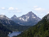
. The Insular Mountains are rugged, particularly on Vancouver Island where peaks in Strathcona Provincial Park
rise to elevations of more than 2000m (6,600 ft). The highest of these mountains is Golden Hinde on Vancouver Island
, which rises to 2196.818 m (7,207 ft).
Although the Coast Mountain Range
is usually referred to as the westernmost range of the Pacific Cordillera
(since it is the westernmost range on the main landmass at that point), the Insular Mountains are the true westernmost range.
, and Vancouver Island
and the Haida Gwaii are just the higher elevations of the range, which was in fact fully exposed during the last ice age
when the continental shelf
in this area was a broad coastal plain
.
The Insular Mountains formed when a chain of active volcanic islands (the Insular Islands
) collided against the North America
n continent during the Mid-Cretaceous
time. The type of rocks that form the Insular Mountains are turbidite
s and pillow lava
s. Granitic
pluton
s seldom occur in the Insular Mountains, unlike the Coast Mountains
. The Insular Mountain range covers some 133,879 km² (51,691 sq mi). It experiences frequent seismic activity
, with the Pacific Plate
and the Juan de Fuca Plate
being subducted into the Earth's mantle
. Large earthquake
s have led to collapsing mountains, landslide
s and fissure
s.
During the most recent ice age
(some 18,000 years ago), ice
enclosed nearly all of these mountains. Glacier
s that ran down to the Pacific Ocean
sharpened the valley
faces and eroded
their bottoms. These valleys were transformed into fjord
s when the ice melted and the sea level
increased. Ice Age remnants may still be noted, such as the Comox Glacier
in the Vancouver Island Ranges
.
The Elk River Mountains
, located in Strathcona Provincial Park
, are sometimes classified as a range.
Mountain range
A mountain range is a single, large mass consisting of a succession of mountains or narrowly spaced mountain ridges, with or without peaks, closely related in position, direction, formation, and age; a component part of a mountain system or of a mountain chain...
in the Pacific Coast Ranges
Pacific Coast Ranges
The Pacific Coast Ranges and the Pacific Mountain System are the series of mountain ranges that stretch along the West Coast of North America from Alaska south to Northern and Central Mexico...
on the coast of British Columbia
British Columbia Coast
The British Columbia Coast or BC Coast is Canada's western continental coastline on the Pacific Ocean. The usage is synonymous with the term West Coast of Canada....
, Canada
Canada
Canada is a North American country consisting of ten provinces and three territories. Located in the northern part of the continent, it extends from the Atlantic Ocean in the east to the Pacific Ocean in the west, and northward into the Arctic Ocean...
, comprising the Vancouver Island Ranges
Vancouver Island Ranges
The Vancouver Island Ranges, formerly called the Vancouver Island Mountains, is a mountain range extending along the length of Vancouver Island which has an area of 31,788 km² . The Vancouver Island Ranges comprise the central and largest part of the island...
and Queen Charlotte Mountains
Queen Charlotte Mountains
The Queen Charlotte Mountains are a mountain range comprising all mountains and small mountain ranges of Haida Gwaii , British Columbia, Canada. It is the northernmost subrange of the Insular Mountains...
. The Insular Mountains are rugged, particularly on Vancouver Island where peaks in Strathcona Provincial Park
Strathcona Provincial Park
Strathcona Provincial Park is the oldest provincial park in British Columbia, Canada, and the largest on Vancouver Island. Founded in 1911, the park was named for Donald Alexander Smith, 1st Baron Strathcona and Mount Royal, a wealthy philanthropist and railroad pioneer. It lies within the...
rise to elevations of more than 2000m (6,600 ft). The highest of these mountains is Golden Hinde on Vancouver Island
Vancouver Island
Vancouver Island is a large island in British Columbia, Canada. It is one of several North American locations named after George Vancouver, the British Royal Navy officer who explored the Pacific Northwest coast of North America between 1791 and 1794...
, which rises to 2196.818 m (7,207 ft).
Although the Coast Mountain Range
Coast Mountains
The Coast Mountains are a major mountain range, in the Pacific Coast Ranges, of western North America, extending from southwestern Yukon through the Alaska Panhandle and virtually all of the Coast of British Columbia. They are so-named because of their proximity to the sea coast, and are often...
is usually referred to as the westernmost range of the Pacific Cordillera
Pacific Cordillera
The Pacific Cordillera is a top-level physiographic region of Canada. This cordillera is part of the Western Cordillera of North America. The mountain ranges in this region were covered during the Pleistocene by the Cordilleran Ice Sheet...
(since it is the westernmost range on the main landmass at that point), the Insular Mountains are the true westernmost range.
Geological history
These Insular Mountains are not yet fully emerged above sea levelSea level
Mean sea level is a measure of the average height of the ocean's surface ; used as a standard in reckoning land elevation...
, and Vancouver Island
Vancouver Island
Vancouver Island is a large island in British Columbia, Canada. It is one of several North American locations named after George Vancouver, the British Royal Navy officer who explored the Pacific Northwest coast of North America between 1791 and 1794...
and the Haida Gwaii are just the higher elevations of the range, which was in fact fully exposed during the last ice age
Ice age
An ice age or, more precisely, glacial age, is a generic geological period of long-term reduction in the temperature of the Earth's surface and atmosphere, resulting in the presence or expansion of continental ice sheets, polar ice sheets and alpine glaciers...
when the continental shelf
Continental shelf
The continental shelf is the extended perimeter of each continent and associated coastal plain. Much of the shelf was exposed during glacial periods, but is now submerged under relatively shallow seas and gulfs, and was similarly submerged during other interglacial periods. The continental margin,...
in this area was a broad coastal plain
Coastal plain
A coastal plain is an area of flat, low-lying land adjacent to a seacoast and separated from the interior by other features. One of the world's longest coastal plains is located in eastern South America. The southwestern coastal plain of North America is notable for its species diversity...
.
The Insular Mountains formed when a chain of active volcanic islands (the Insular Islands
Insular Islands
The Insular Islands were a giant chain of active volcanic islands somewhere in the Pacific Ocean during the Cretaceous time that rode on top a microplate called the Insular Plate, beginning around 130 million years ago. The Insular Islands were surrounded by two prehistoric oceans; the Panthalassa...
) collided against the North America
North America
North America is a continent wholly within the Northern Hemisphere and almost wholly within the Western Hemisphere. It is also considered a northern subcontinent of the Americas...
n continent during the Mid-Cretaceous
Cretaceous
The Cretaceous , derived from the Latin "creta" , usually abbreviated K for its German translation Kreide , is a geologic period and system from circa to million years ago. In the geologic timescale, the Cretaceous follows the Jurassic period and is followed by the Paleogene period of the...
time. The type of rocks that form the Insular Mountains are turbidite
Turbidite
Turbidite geological formations have their origins in turbidity current deposits, which are deposits from a form of underwater avalanche that are responsible for distributing vast amounts of clastic sediment into the deep ocean.-The ideal turbidite sequence:...
s and pillow lava
Pillow lava
Pillow lavas are lavas that contain characteristic pillow-shaped structures that are attributed to the extrusion of the lava under water, or subaqueous extrusion. Pillow lavas in volcanic rock are characterized by thick sequences of discontinuous pillow-shaped masses, commonly up to one metre in...
s. Granitic
Granite
Granite is a common and widely occurring type of intrusive, felsic, igneous rock. Granite usually has a medium- to coarse-grained texture. Occasionally some individual crystals are larger than the groundmass, in which case the texture is known as porphyritic. A granitic rock with a porphyritic...
pluton
Pluton
A pluton in geology is a body of intrusive igneous rock that crystallized from magma slowly cooling below the surface of the Earth. Plutons include batholiths, dikes, sills, laccoliths, lopoliths, and other igneous bodies...
s seldom occur in the Insular Mountains, unlike the Coast Mountains
Coast Mountains
The Coast Mountains are a major mountain range, in the Pacific Coast Ranges, of western North America, extending from southwestern Yukon through the Alaska Panhandle and virtually all of the Coast of British Columbia. They are so-named because of their proximity to the sea coast, and are often...
. The Insular Mountain range covers some 133,879 km² (51,691 sq mi). It experiences frequent seismic activity
Seismology
Seismology is the scientific study of earthquakes and the propagation of elastic waves through the Earth or through other planet-like bodies. The field also includes studies of earthquake effects, such as tsunamis as well as diverse seismic sources such as volcanic, tectonic, oceanic,...
, with the Pacific Plate
Pacific Plate
The Pacific Plate is an oceanic tectonic plate that lies beneath the Pacific Ocean. At 103 million square kilometres, it is the largest tectonic plate....
and the Juan de Fuca Plate
Juan de Fuca Plate
The Juan de Fuca Plate, named after the explorer of the same name, is a tectonic plate, generated from the Juan de Fuca Ridge, and subducting under the northerly portion of the western side of the North American Plate at the Cascadia subduction zone...
being subducted into the Earth's mantle
Mantle (geology)
The mantle is a part of a terrestrial planet or other rocky body large enough to have differentiation by density. The interior of the Earth, similar to the other terrestrial planets, is chemically divided into layers. The mantle is a highly viscous layer between the crust and the outer core....
. Large earthquake
Earthquake
An earthquake is the result of a sudden release of energy in the Earth's crust that creates seismic waves. The seismicity, seismism or seismic activity of an area refers to the frequency, type and size of earthquakes experienced over a period of time...
s have led to collapsing mountains, landslide
Landslide
A landslide or landslip is a geological phenomenon which includes a wide range of ground movement, such as rockfalls, deep failure of slopes and shallow debris flows, which can occur in offshore, coastal and onshore environments...
s and fissure
Fissure
In anatomy, a fissure is a groove, natural division, deep furrow, elongated cleft, or tear in various parts of the body.-Brain:...
s.
During the most recent ice age
Ice age
An ice age or, more precisely, glacial age, is a generic geological period of long-term reduction in the temperature of the Earth's surface and atmosphere, resulting in the presence or expansion of continental ice sheets, polar ice sheets and alpine glaciers...
(some 18,000 years ago), ice
Ice
Ice is water frozen into the solid state. Usually ice is the phase known as ice Ih, which is the most abundant of the varying solid phases on the Earth's surface. It can appear transparent or opaque bluish-white color, depending on the presence of impurities or air inclusions...
enclosed nearly all of these mountains. Glacier
Glacier
A glacier is a large persistent body of ice that forms where the accumulation of snow exceeds its ablation over many years, often centuries. At least 0.1 km² in area and 50 m thick, but often much larger, a glacier slowly deforms and flows due to stresses induced by its weight...
s that ran down to the Pacific Ocean
Pacific Ocean
The Pacific Ocean is the largest of the Earth's oceanic divisions. It extends from the Arctic in the north to the Southern Ocean in the south, bounded by Asia and Australia in the west, and the Americas in the east.At 165.2 million square kilometres in area, this largest division of the World...
sharpened the valley
Valley
In geology, a valley or dale is a depression with predominant extent in one direction. A very deep river valley may be called a canyon or gorge.The terms U-shaped and V-shaped are descriptive terms of geography to characterize the form of valleys...
faces and eroded
Erosion
Erosion is when materials are removed from the surface and changed into something else. It only works by hydraulic actions and transport of solids in the natural environment, and leads to the deposition of these materials elsewhere...
their bottoms. These valleys were transformed into fjord
Fjord
Geologically, a fjord is a long, narrow inlet with steep sides or cliffs, created in a valley carved by glacial activity.-Formation:A fjord is formed when a glacier cuts a U-shaped valley by abrasion of the surrounding bedrock. Glacial melting is accompanied by rebound of Earth's crust as the ice...
s when the ice melted and the sea level
Sea level
Mean sea level is a measure of the average height of the ocean's surface ; used as a standard in reckoning land elevation...
increased. Ice Age remnants may still be noted, such as the Comox Glacier
Comox Glacier
The Comox Glacier is a glacier on Vancouver Island, British Columbia, Canada, located southwest of Courtenay and west of Argus Mountain.The highest elevation of the Comox Glacier, , refers to a rocky outcrop on the north side of the glacier...
in the Vancouver Island Ranges
Vancouver Island Ranges
The Vancouver Island Ranges, formerly called the Vancouver Island Mountains, is a mountain range extending along the length of Vancouver Island which has an area of 31,788 km² . The Vancouver Island Ranges comprise the central and largest part of the island...
.
Haida Gwaii
- Queen Charlotte MountainsQueen Charlotte MountainsThe Queen Charlotte Mountains are a mountain range comprising all mountains and small mountain ranges of Haida Gwaii , British Columbia, Canada. It is the northernmost subrange of the Insular Mountains...
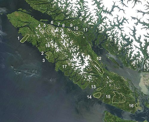
, on Haida Gwaii (formerly Queen Charlotte Islands):
- Cameron RangeCameron RangeThe Cameron Range is a small, low mountain range in northernwestern British Columbia, Canada, located on the north side of Port Chanal on the western side of Graham Island of the Queen Charlotte Islands. It has an area of 41 km2 and is a subrange of the Queen Charlotte Mountains which in turn form...
: On the western side of Graham IslandGraham IslandGraham Island is the largest island in the Haida Gwaii archipelago , lying off the coast of British Columbia, Canada. It is separated only by a narrow channel from the other principal island of the group, Moresby Island Graham Island is the largest island in the Haida Gwaii archipelago (formerly... - Crease RangeCrease RangeThe Crease Range is a small, low mountain range in northernwestern British Columbia, Canada, located on north-central Graham Island of the Queen Charlotte Islands, between Lan and Adam Lakes. It has an area of 79 km2 and consists of hills. It is a subrange of the Queen Charlotte Mountains which in...
: On north-central Graham Island - McKay RangeMcKay RangeThe McKay Range is a small, low mountain range in northwestern British Columbia, Canada, located on the southern coast of Graham Island in the Queen Charlotte Islands. It has an area of 60 km2 and consists of hills. It is a subrange of the Queen Charlotte Mountains which in turn form part of the...
: On the south coast of Graham Island - San Christoval RangeSan Christoval RangeThe San Christoval Range is a 50 km long, jagged mountain range located on the west coast of Moresby Island, British Columbia, Canada. It is the only lineal mountain range in the Queen Charlotte Mountains and the highest peaks are just above 1000 m. The mountain range was named by Juan José...
: On the western side of Moresby IslandMoresby IslandMoresby Island is a large island that forms part of the Haida Gwaii archipelago in British Columbia, Canada, located at . Gwaii Haanas National Park Reserve and Haida Heritage Site includes Moresby and other islands...
Vancouver Island
- Vancouver Island RangesVancouver Island RangesThe Vancouver Island Ranges, formerly called the Vancouver Island Mountains, is a mountain range extending along the length of Vancouver Island which has an area of 31,788 km² . The Vancouver Island Ranges comprise the central and largest part of the island...
, on Vancouver IslandVancouver IslandVancouver Island is a large island in British Columbia, Canada. It is one of several North American locations named after George Vancouver, the British Royal Navy officer who explored the Pacific Northwest coast of North America between 1791 and 1794...
:
- Refugium RangeRefugium RangeThe Refugium Range is a low, small mountain range comprising the mountains/hills of the Brooks Peninsula on northern Vancouver Island, British Columbia, Canada. It has an area of and is a subrange of the Vancouver Island Ranges which in turn form part of the Insular Mountains...
: On the Brooks Peninsula - Sophia RangeSophia RangeThe Sophia Range is a low, small mountain range on southern Nootka Island, forming a peninsula west of Tahsis Inlet, between Esperanza Inlet and Nuchatlitz Inlet, British Columbia, Canada. It is made up of hills and has an area of 150 km2 and is a subrange of the Vancouver Island Ranges which...
: On Nootka Island, on the peninsula between Esperanza Inlet and Nuchatlitz Inlet - Genevieve RangeGenevieve RangeThe Genevieve Range is a low, small mountain range on western Nootka Island, which is on the western side of Nootka Sound, British Columbia, Canada. It consists of hills and has an area of 101 km2 and is a subrange of the Vancouver Island Ranges which in turn form part of the Insular Mountains....
: Nootka IslandNootka IslandNootka Island is an island near Vancouver Island in British Columbia, Canada. It contains 534 km² of area. It is separated from Vancouver Island by Nootka Sound and its side-inlets.... - Karmutzen RangeKarmutzen RangeThe Karmutzen Range is a small mountain range in British Columbia, Canada, located west of Nimpkish Lake on Vancouver Island, north of Tlakwa Creek and south and east of Karmuzten Creek. It is has an area of 64 km2 and is a subrange of the Vancouver Island Ranges which in turn form part of the...
: Between Nimpkish Lake, Tlakwa Creek and Karmuzten Creek - Hankin RangeHankin RangeThe Hankin Range is a small mountain range on Vancouver Island, British Columbia, Canada, located between Nimpkish and Bonanza Lakes. It is has an area of 287 km2 and is a subrange of the Vancouver Island Ranges which in turn form part of the Insular Mountains....
: Between Nimpkish Lake and Bonanza Lake - Franklin RangeFranklin RangeThe Franklin Range is a small mountain range on Vancouver Island, British Columbia, Canada, located just southwest of Robson Bight and Johnstone Strait. It has an area of 200 km2 and is a subrange of the Vancouver Island Ranges which in turn form part of the Insular Mountains...
: Near Robson BightRobson BightRobson Bight is a small Vancouver Island bay at the west end of Johnstone Strait across from West Cracroft Island in British Columbia, Canada that includes a protected killer whale habitat famous for its whale-rubbing beaches...
on the Johnstone StraitJohnstone StraitJohnstone Strait is a channel along the north east coast of Vancouver Island in British Columbia, Canada. Opposite the Vancouver Island coast, running north to south, are Hanson Island, West Cracroft Island, the mainland British Columbia Coast, Hardwick Island, West Thurlow Island and East...
between the Tsitika River and Kokish River - Bonanza RangeBonanza RangeThe Bonanza Range is a small mountain range on Vancouver Island, British Columbia, Canada, located in the area between the Nimpkish River and the Tsitika River. It has an area of 150 km2 and is a subrange of the Vancouver Island Ranges which in turn form part of the Insular Mountains....
: Between the Nimpkish River and the Tsitika River by Bonanza Lake - Sutton RangeSutton RangeThe Sutton Range is a mountain range on Vancouver Island, British Columbia, Canada, located in the area between the headwaters of the Nimpkish River and those of the White River. It has an area of 448 km2 and is a subrange of the Vancouver Island Ranges which in turn form part of the Insular...
: Between Nimpkish River, White River, Oktwanch River, Gold River - Newcastle Range: Johnstone Strait, west of Sayward-Kelsey Bay and east/north of Adams River
- Prince of Wales RangePrince of Wales RangeThe Prince of Wales Range is a small mountain range on the east central coast of Vancouver Island, British Columbia, Canada, located about north of Campbell River. It has an area of 188 km2 and is a subrange of the Vancouver Island Ranges which in turn form part of the Insular Mountains....
: East coast of Vancouver Island 40 km (25 mi) north of Campbell River - Halifax RangeHalifax RangeThe Halifax Range is a small mountain range on Vancouver Island, British Columbia, Canada, adjacent to Johnstone Strait, between Amor de Cosmos Creek and Pye Creek. It consists of hills and has an area of 51 km2 and is a subrange of the Vancouver Island Ranges which in turn form part of the Insular...
: Along Johnstone Strait between Amor de Cosmos Creek and Pye Creek - Beaufort RangeBeaufort RangeThe Beaufort Range is a mountain range on southern Vancouver Island, British Columbia, Canada, located north of Port Alberni and to the west of Qualicum Beach. It has an area of 448 km2 and is a subrange of the Vancouver Island Ranges which in turn form part of the Insular Mountains.The highest...
: North of Port AlberniPort Alberni, British ColumbiaPort Alberni is a city located in the province of British Columbia in Canada. It is the location of the head offices of the Alberni-Clayoquot Regional District. The city has a total population of 17,743, and the census agglomeration area a total of 25,396....
and west of Qualicum BeachQualicum Beach, British ColumbiaQualicum Beach is a town in the Regional District of Nanaimo, British Columbia, Canada. As of the 2006 census, the town had 8,502 people.On the Strait of Georgia on the north-eastern coast of Vancouver Island in the shadow of Mount Arrowsmith, the community has been a popular tourist destination,... - Pelham RangePelham RangeThe Pelham Range is a small mountain range on southern Vancouver Island, British Columbia, Canada, located northeast of Sarita and between the Sarita River and Albemi Inlet. It has an area of 52 km2 and is a subrange of the Vancouver Island Ranges which in turn form part of the Insular Mountains....
: Between the Sarita River and Alberni Inlet - Somerset RangeSomerset RangeThe Somerset Range is a low mountain range comprising the mountains/hills between Nitinat Lake and Barkley Sound's Imperial Eagle Channel on northern Vancouver Island, British Columbia, Canada. It has an area of 203 km2 and is a subrange of the Vancouver Island Ranges which in turn form part of the...
: Between The Pacheena-Sarita River basins and the Klanawa River (between Nitinat Lake and Imperial Eagle Channel) - Seymour RangeSeymour RangeThe Seymour Range is a low and small mountain range comprising the mountains/hills between the valley of Cowichan Lake and that of the San Juan River on southern Vancouver Island, British Columbia, Canada. It has an area of 888 km2 and is a subrange of the Vancouver Island Ranges which in turn form...
: Between the valley of Cowichan Lake, San Juan River and Gordon River - Gowlland RangeGowlland RangeThe Gowlland Range is a low, small mountain range on southern Vancouver Island, British Columbia, Canada, located just east of Saanich Inlet and south of Brentwood Bay. It has an area of 58 km2 and is a subrange of the Vancouver Island Ranges which in turn form part of the Insular Mountains....
: Near Victoria between Saanich InletSaanich InletSaanich Inlet is a body of salt water that lies between the Saanich Peninsula and the Malahat highlands of Vancouver Island, British Columbia, Canada. Located just northwest of Victoria, the inlet is 24 km long , has a surface area of 65 km2 , and its maximum depth is 225 m . Great...
and Brentwood Bay. Includes Mount Work Regional Park - Pierce RangePierce RangeThe Pierce Range is a small very steep-sided mountain range on central Vancouver Island, British Columbia, Canada. It has an area of 94 km2 and is a subrange of the Vancouver Island Ranges which in turn form part of the Insular Mountains....
: South of Gold River between the Jacklah River and the Burman River - Haihte RangeHaihte RangeThe Haihte Range is a small mountain range on central Vancouver Island, British Columbia, Canada. It has an area of 75 km2 and is a subrange of the Vancouver Island Ranges which in turn form part of the Insular Mountains....
: Between Tashsis River, the Nomash River, Zeballos Lake and Woss Lake
The Elk River Mountains
Elk River Mountains
The Elk River Mountains is a rugged group of mountains in the heart of Strathcona Provincial Park on Vancouver Island, British Columbia, Canada. It has an area of 113 km2 and is part of the Vancouver Island Ranges which in turn form part of the Insular Mountains....
, located in Strathcona Provincial Park
Strathcona Provincial Park
Strathcona Provincial Park is the oldest provincial park in British Columbia, Canada, and the largest on Vancouver Island. Founded in 1911, the park was named for Donald Alexander Smith, 1st Baron Strathcona and Mount Royal, a wealthy philanthropist and railroad pioneer. It lies within the...
, are sometimes classified as a range.