
Høyanger
Encyclopedia
is a municipality in the county
of Sogn og Fjordane
, Norway
. It is located in the traditional district
of Sogn
. The administrative center is the village of Høyanger, which has 2177 inhabitants (2009). Other villages in Høyanger include Lavik
, Kyrkjebø
, Austreim
, and Vadheim
. Høyanger was created on 1 January 1964 when the municipalities of Kyrkjebø
and Lavik
were merged.
Høyanger is known for being one of the first industrial towns in Norway
to use its steep mountains surrounding the town giving excellent conditions for producing hydroelectricity
needed for electrolysis
. The main product being produced in Høyanger was aluminium
.
). The municipality was created to be identical to the Ladevig parish
(prestegjeld
). In 1858, the district of Klævold
(population: 1,645) was separated from Ladvig
to constitute a municipality of its own. This left Ladvig with a population of 2,042. (The name Klævold was changed to Kirkebø on 1 July 1890 and later changed to Kyrkjebø
in 1917).
In 1861, Lavik
(population: 926) was merged with Brekke
municipality (population: 898), located across the Sognefjord
, to form the new municipality of Lavik og Brekke
. In 1862 the sub-parish (sokn) of Bø in the western part of the municipality was removed from Lavik og Brekke
and merged with the Øn and Hyllestad sub-parishes (sokn) from Askvoll
to form a new municipality which was named Hyllestad
. On 1 January 1875, a part of Klævold
with 90 inhabitants was moved to Lavik og Brekke
.
On 1 January 1905, the municipality was split into two separate municipalities: Lavik
(population: 1,182) and Brekke
(population: 982). Then on 1 January 1964, a new municipality named Høyanger was created. It consisted of the former municipalities of Lavik
(population: 894) and Kyrkjebø
(population: 4,742) along with the Nybø and Nygjerdet farms in Vik
. Today's municipality is identical to the Lavik parish
(prestegjeld) which is made up of the sub-parishes (sokns) of Høyanger, Kyrkjebø, Lavik, and Bjordal og Ortnevik.
(now called Høyangsfjord). The first element is høy which means "hay
" and the last element is angr which means "fjord
". The word høy is probably referring to the green hillsides along the fjord.
is from modern times. The arms were granted on 15 May 1987. It shows three flame
s as a symbol for the local aluminium industry. Aluminium
is melted and purified in Høyanger, due to the cheap hydroelectric energy that is locally available. The colors represent waterpower
(blue) and aluminium
(silver).
 The Church of Norway
has six churches within the municipality of Høyanger. It is part of the Diocese of Bjørgvin
and the Rural Deanery
(Prosti) of Ytre Sogn
.
(through 10th grade), outpatient health services
, senior citizen
services, unemployment
and other social services
, zoning
, economic development
, and municipal road
s. The municipality is governed by a municipal council of elected representatives, which in turn elect a mayor
.
breakdown is as follows:
(ordførar) of a municipality in Norway is a representative of the majority party of the municipal council who is elected to lead the council. The mayor for the 2007-2011 term is Kjartan Longva of the Labour Party
'.
county. The Sognefjord
runs through the center of the municipality. Høyanger is bordered to the north by the municipalities of Fjaler
and Gaular
, to the east by Balestrand
and Vik
, to the south by Modalen
and Masfjorden
(in Hordaland
county), and to the west by Gulen
and Hyllestad
.
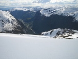
Høyanger municipality covers an area of about 910 square kilometres (351.4 sq mi). Stølsheimen Nature Reserve was created in 1990 in Høyanger. Its 367 square kilometres (141.7 sq mi) area stretches from high mountaintops through fertile valley
s and sweeps over steep meadow
s down to the fjord
. Høyanger is perhaps best known for its mountain
farms and lakes. From the village of Ortnevik there are marked footpaths up to Stølsheimen Park and from the village of Bjordal you may drive up the Stordal road to the summit at 730 metres (2,395 ft) above sea level.
and Høyanger Metallverk. Hydroelectricity
has played a major role in the development of the area. In addition to manufacturing aluminium
, Høyanger supports a varied range of light industry that is backed by retail and service trades. In the rural areas bordering the fjord, farming
is the main source of livelihood. There are currently 115 traditional farms gårds in the municipality. Each traditional farms originally had one owner, but most of them have been divided up and sold off over the years, and so there are more than 115 farms in use today.
and Bergen
by bus, as well as air and fast boat services. The nearest airport is in Førde
, about 50 kilometres away. The village of Lavik
is an important junction for traffic to and from Bergen. Høyanger is reached from the neighboring municipality of Balestrand
to the east by the Høyangertunnelen which is 7.5 kilometers in length. It is one of the longest tunnel
s in Europe
. Good ferry services across the Sognefjord
link the northern and southern sides of the municipality.
as a whole. Visitors will get to learn about how the aluminium industry has grown and prospered in the area thanks to the vast energy
produced by water
.
Near Vadheim is an 18th-century stone bridge called the Ytredal Bridge. It is a popular tourist attraction.
Counties of Norway
Norway is divided into 19 administrative regions, called counties . The counties form the primary first-level subdivisions of Norway and are further divided into 430 municipalities...
of Sogn og Fjordane
Sogn og Fjordane
is a county in Norway, bordering Møre og Romsdal, Oppland, Buskerud, and Hordaland. The county administration is in the town of Hermansverk in Leikanger municipality while the largest town is Førde....
, Norway
Norway
Norway , officially the Kingdom of Norway, is a Nordic unitary constitutional monarchy whose territory comprises the western portion of the Scandinavian Peninsula, Jan Mayen, and the Arctic archipelago of Svalbard and Bouvet Island. Norway has a total area of and a population of about 4.9 million...
. It is located in the traditional district
Districts of Norway
The country Norway is historically divided into a number of districts. Many districts have deep historical roots, and only partially coincide with today's administrative units of counties and municipalities. The districts are defined by geographical features, often valleys, mountain ranges, fjords,...
of Sogn
Sogn
Sogn is a traditional district in Western Norway . It is located in the county of Sogn og Fjordane, surrounding the Sognefjord. Sogn consists of the municipalities of Aurland, Balestrand, Hyllestad, Høyanger, Gulen, Leikanger, Luster, Lærdal, Sogndal, Solund, Vik, and Årdal. The district covers ...
. The administrative center is the village of Høyanger, which has 2177 inhabitants (2009). Other villages in Høyanger include Lavik
Lavik
Lavik is a village and former municipality in Sogn og Fjordane county in Norway. It is located in the eastern part of the present-day municipality of Høyanger...
, Kyrkjebø
Kyrkjebø
Kyrkjebø is a village and a former municipality in Sogn og Fjordane county in Norway. It is located in the northwestern part of the present-day municipality of Høyanger...
, Austreim
Austreim
Austreim is a village in the municipality of Høyanger in Sogn og Fjordane county, Norway. The village is located on the north shore of the Sognefjord, about southwest of the municipal center of Høyanger, about east of Kyrkjebø, and about southeast of Vadheim and the highway . The village has a...
, and Vadheim
Vadheim
Vadheim is a village in the municipality of Høyanger in Sogn og Fjordane county, Norway. It is located on the north shore of the Sognefjord, along the highway . It is about northeast of the village of Lavik, northwest of Kyrkjebø, and northwest of Austreim...
. Høyanger was created on 1 January 1964 when the municipalities of Kyrkjebø
Kyrkjebø
Kyrkjebø is a village and a former municipality in Sogn og Fjordane county in Norway. It is located in the northwestern part of the present-day municipality of Høyanger...
and Lavik
Lavik
Lavik is a village and former municipality in Sogn og Fjordane county in Norway. It is located in the eastern part of the present-day municipality of Høyanger...
were merged.
Høyanger is known for being one of the first industrial towns in Norway
Norway
Norway , officially the Kingdom of Norway, is a Nordic unitary constitutional monarchy whose territory comprises the western portion of the Scandinavian Peninsula, Jan Mayen, and the Arctic archipelago of Svalbard and Bouvet Island. Norway has a total area of and a population of about 4.9 million...
to use its steep mountains surrounding the town giving excellent conditions for producing hydroelectricity
Hydroelectricity
Hydroelectricity is the term referring to electricity generated by hydropower; the production of electrical power through the use of the gravitational force of falling or flowing water. It is the most widely used form of renewable energy...
needed for electrolysis
Electrolysis
In chemistry and manufacturing, electrolysis is a method of using a direct electric current to drive an otherwise non-spontaneous chemical reaction...
. The main product being produced in Høyanger was aluminium
Aluminium
Aluminium or aluminum is a silvery white member of the boron group of chemical elements. It has the symbol Al, and its atomic number is 13. It is not soluble in water under normal circumstances....
.
General information
Ladvig was established as a municipality on 1 January 1838 (see formannskapsdistriktFormannskapsdistrikt
Formannskapsdistrikt was the name for a Norwegian local self-government districts put into force in 1838. This system of municipality was created in a bill approved by the Storting and signed into law by King Carl Johan on 14 January 1837...
). The municipality was created to be identical to the Ladevig parish
Church of Norway
The Church of Norway is the state church of Norway, established after the Lutheran reformation in Denmark-Norway in 1536-1537 broke the ties to the Holy See. The church confesses the Lutheran Christian faith...
(prestegjeld
Prestegjeld
A Prestegjeld is a geographic and administrative area of the Church of Norway roughly equivalent to a parish. A prestegjeld can consist of one or many congregations...
). In 1858, the district of Klævold
Kyrkjebø
Kyrkjebø is a village and a former municipality in Sogn og Fjordane county in Norway. It is located in the northwestern part of the present-day municipality of Høyanger...
(population: 1,645) was separated from Ladvig
Lavik
Lavik is a village and former municipality in Sogn og Fjordane county in Norway. It is located in the eastern part of the present-day municipality of Høyanger...
to constitute a municipality of its own. This left Ladvig with a population of 2,042. (The name Klævold was changed to Kirkebø on 1 July 1890 and later changed to Kyrkjebø
Kyrkjebø
Kyrkjebø is a village and a former municipality in Sogn og Fjordane county in Norway. It is located in the northwestern part of the present-day municipality of Høyanger...
in 1917).
In 1861, Lavik
Lavik
Lavik is a village and former municipality in Sogn og Fjordane county in Norway. It is located in the eastern part of the present-day municipality of Høyanger...
(population: 926) was merged with Brekke
Brekke
Brekke is a village and former municipality in Sogn og Fjordane county, Norway. It is located in the northeastern part of the present-day municipality of Gulen in the traditional district of Sogn...
municipality (population: 898), located across the Sognefjord
Sognefjord
The Sognefjord is the largest fjord in Norway, and the second longest in the world. Located in Sogn og Fjordane county, it stretches inland to the small village of Skjolden...
, to form the new municipality of Lavik og Brekke
Lavik og Brekke
Lavik og Brekke is a former municipality in Sogn og Fjordane county in Norway. It is located in the present-day municipalities of Gulen and Høyanger. It was part of the traditional district of Sogn. The administrative center of Lavik og Brekke was the village of Lavik.-Name:The municipality of...
. In 1862 the sub-parish (sokn) of Bø in the western part of the municipality was removed from Lavik og Brekke
Lavik og Brekke
Lavik og Brekke is a former municipality in Sogn og Fjordane county in Norway. It is located in the present-day municipalities of Gulen and Høyanger. It was part of the traditional district of Sogn. The administrative center of Lavik og Brekke was the village of Lavik.-Name:The municipality of...
and merged with the Øn and Hyllestad sub-parishes (sokn) from Askvoll
Askvoll
is a municipality in the county of Sogn og Fjordane, Norway. It is located in the traditional district of Sunnfjord. The administrative centre is the village of Askvoll....
to form a new municipality which was named Hyllestad
Hyllestad
Hyllestad is a municipality in the county of Sogn og Fjordane, Norway. It is located in the traditional district of Sogn. The administrative center of Hyllestad is the village of Hyllestad....
. On 1 January 1875, a part of Klævold
Kyrkjebø
Kyrkjebø is a village and a former municipality in Sogn og Fjordane county in Norway. It is located in the northwestern part of the present-day municipality of Høyanger...
with 90 inhabitants was moved to Lavik og Brekke
Lavik og Brekke
Lavik og Brekke is a former municipality in Sogn og Fjordane county in Norway. It is located in the present-day municipalities of Gulen and Høyanger. It was part of the traditional district of Sogn. The administrative center of Lavik og Brekke was the village of Lavik.-Name:The municipality of...
.
On 1 January 1905, the municipality was split into two separate municipalities: Lavik
Lavik
Lavik is a village and former municipality in Sogn og Fjordane county in Norway. It is located in the eastern part of the present-day municipality of Høyanger...
(population: 1,182) and Brekke
Brekke
Brekke is a village and former municipality in Sogn og Fjordane county, Norway. It is located in the northeastern part of the present-day municipality of Gulen in the traditional district of Sogn...
(population: 982). Then on 1 January 1964, a new municipality named Høyanger was created. It consisted of the former municipalities of Lavik
Lavik
Lavik is a village and former municipality in Sogn og Fjordane county in Norway. It is located in the eastern part of the present-day municipality of Høyanger...
(population: 894) and Kyrkjebø
Kyrkjebø
Kyrkjebø is a village and a former municipality in Sogn og Fjordane county in Norway. It is located in the northwestern part of the present-day municipality of Høyanger...
(population: 4,742) along with the Nybø and Nygjerdet farms in Vik
Vik
Vik is a municipality in the county of Sogn og Fjordane, Norway. It is located in the traditional district of Sogn. The administrative center of Vik is the village of Vikøyri.-General information:...
. Today's municipality is identical to the Lavik parish
Church of Norway
The Church of Norway is the state church of Norway, established after the Lutheran reformation in Denmark-Norway in 1536-1537 broke the ties to the Holy See. The church confesses the Lutheran Christian faith...
(prestegjeld) which is made up of the sub-parishes (sokns) of Høyanger, Kyrkjebø, Lavik, and Bjordal og Ortnevik.
Name
The name originally belonged to an arm of SognefjordSognefjord
The Sognefjord is the largest fjord in Norway, and the second longest in the world. Located in Sogn og Fjordane county, it stretches inland to the small village of Skjolden...
(now called Høyangsfjord). The first element is høy which means "hay
Hay
Hay is grass, legumes or other herbaceous plants that have been cut, dried, and stored for use as animal fodder, particularly for grazing livestock such as cattle, horses, goats, and sheep. Hay is also fed to pets such as rabbits and guinea pigs...
" and the last element is angr which means "fjord
Fjord
Geologically, a fjord is a long, narrow inlet with steep sides or cliffs, created in a valley carved by glacial activity.-Formation:A fjord is formed when a glacier cuts a U-shaped valley by abrasion of the surrounding bedrock. Glacial melting is accompanied by rebound of Earth's crust as the ice...
". The word høy is probably referring to the green hillsides along the fjord.
Coat-of-arms
The coat of armsCoat of arms
A coat of arms is a unique heraldic design on a shield or escutcheon or on a surcoat or tabard used to cover and protect armour and to identify the wearer. Thus the term is often stated as "coat-armour", because it was anciently displayed on the front of a coat of cloth...
is from modern times. The arms were granted on 15 May 1987. It shows three flame
Flame
A flame is the visible , gaseous part of a fire. It is caused by a highly exothermic reaction taking place in a thin zone...
s as a symbol for the local aluminium industry. Aluminium
Aluminium
Aluminium or aluminum is a silvery white member of the boron group of chemical elements. It has the symbol Al, and its atomic number is 13. It is not soluble in water under normal circumstances....
is melted and purified in Høyanger, due to the cheap hydroelectric energy that is locally available. The colors represent waterpower
Hydropower
Hydropower, hydraulic power, hydrokinetic power or water power is power that is derived from the force or energy of falling water, which may be harnessed for useful purposes. Since ancient times, hydropower has been used for irrigation and the operation of various mechanical devices, such as...
(blue) and aluminium
Aluminium
Aluminium or aluminum is a silvery white member of the boron group of chemical elements. It has the symbol Al, and its atomic number is 13. It is not soluble in water under normal circumstances....
(silver).
Churches
Church of Norway
The Church of Norway is the state church of Norway, established after the Lutheran reformation in Denmark-Norway in 1536-1537 broke the ties to the Holy See. The church confesses the Lutheran Christian faith...
has six churches within the municipality of Høyanger. It is part of the Diocese of Bjørgvin
Diocese of Bjørgvin
Bjørgvin Diocese is a diocese in the Church of Norway. It covers churches located in the counties of Hordaland and Sogn og Fjordane. The cathedral city is Bergen. Bergen Cathedral, formerly the Church of Saint Olaf, serves as the seat of the presiding Bishop...
and the Rural Deanery
Deanery
A Deanery is an ecclesiastical entity in both the Roman Catholic Church and the Church of England. A deanery is either the jurisdiction or residence of a Dean.- Catholic usage :...
(Prosti) of Ytre Sogn
Sogn
Sogn is a traditional district in Western Norway . It is located in the county of Sogn og Fjordane, surrounding the Sognefjord. Sogn consists of the municipalities of Aurland, Balestrand, Hyllestad, Høyanger, Gulen, Leikanger, Luster, Lærdal, Sogndal, Solund, Vik, and Årdal. The district covers ...
.
| Parish (Prestegjeld) | Sub-Parish (Sogn) | Church Name | Year Built | Location of the Church |
|---|---|---|---|---|
| Lavik Parish | Bjordal og Ortnevik | Bjordal kyrkje | 1906 | Bjordal |
| Ortnevik kyrkje | 1925 | Ortnevik | ||
| Høyanger | Høyanger kyrkje | 1960 | Høyanger | |
| Kyrkjebø | Kyrkjebø kyrkje | 1869 | Kyrkjebø Kyrkjebø Kyrkjebø is a village and a former municipality in Sogn og Fjordane county in Norway. It is located in the northwestern part of the present-day municipality of Høyanger... |
|
| Vadheim bedehuskapell | 1916 | Vadheim Vadheim Vadheim is a village in the municipality of Høyanger in Sogn og Fjordane county, Norway. It is located on the north shore of the Sognefjord, along the highway . It is about northeast of the village of Lavik, northwest of Kyrkjebø, and northwest of Austreim... |
||
| Lavik | Lavik kyrkje | 1865 | Lavik Lavik Lavik is a village and former municipality in Sogn og Fjordane county in Norway. It is located in the eastern part of the present-day municipality of Høyanger... |
Government
All municipalities in Norway, including Høyanger, are responsible for primary educationPrimary education
A primary school is an institution in which children receive the first stage of compulsory education known as primary or elementary education. Primary school is the preferred term in the United Kingdom and many Commonwealth Nations, and in most publications of the United Nations Educational,...
(through 10th grade), outpatient health services
Health care
Health care is the diagnosis, treatment, and prevention of disease, illness, injury, and other physical and mental impairments in humans. Health care is delivered by practitioners in medicine, chiropractic, dentistry, nursing, pharmacy, allied health, and other care providers...
, senior citizen
Old age
Old age consists of ages nearing or surpassing the average life span of human beings, and thus the end of the human life cycle...
services, unemployment
Unemployment
Unemployment , as defined by the International Labour Organization, occurs when people are without jobs and they have actively sought work within the past four weeks...
and other social services
Social work
Social Work is a professional and academic discipline that seeks to improve the quality of life and wellbeing of an individual, group, or community by intervening through research, policy, community organizing, direct practice, and teaching on behalf of those afflicted with poverty or any real or...
, zoning
Zoning
Zoning is a device of land use planning used by local governments in most developed countries. The word is derived from the practice of designating permitted uses of land based on mapped zones which separate one set of land uses from another...
, economic development
Economic development
Economic development generally refers to the sustained, concerted actions of policymakers and communities that promote the standard of living and economic health of a specific area...
, and municipal road
Road
A road is a thoroughfare, route, or way on land between two places, which typically has been paved or otherwise improved to allow travel by some conveyance, including a horse, cart, or motor vehicle. Roads consist of one, or sometimes two, roadways each with one or more lanes and also any...
s. The municipality is governed by a municipal council of elected representatives, which in turn elect a mayor
Mayor
In many countries, a Mayor is the highest ranking officer in the municipal government of a town or a large urban city....
.
Municipal council
The municipal council (Kommunestyre) of Høyanger is made up of 21 representatives that are elected to every four years. For 2011–2015, the partyPolitical party
A political party is a political organization that typically seeks to influence government policy, usually by nominating their own candidates and trying to seat them in political office. Parties participate in electoral campaigns, educational outreach or protest actions...
breakdown is as follows:
Mayor
The mayorMayor
In many countries, a Mayor is the highest ranking officer in the municipal government of a town or a large urban city....
(ordførar) of a municipality in Norway is a representative of the majority party of the municipal council who is elected to lead the council. The mayor for the 2007-2011 term is Kjartan Longva of the Labour Party
Norwegian Labour Party
The Labour Party is a social-democratic political party in Norway. It is the senior partner in the current Norwegian government as part of the Red-Green Coalition, and its leader, Jens Stoltenberg, is the current Prime Minister of Norway....
'.
Geography
Høyanger forms part of the southern border of Sogn og FjordaneSogn og Fjordane
is a county in Norway, bordering Møre og Romsdal, Oppland, Buskerud, and Hordaland. The county administration is in the town of Hermansverk in Leikanger municipality while the largest town is Førde....
county. The Sognefjord
Sognefjord
The Sognefjord is the largest fjord in Norway, and the second longest in the world. Located in Sogn og Fjordane county, it stretches inland to the small village of Skjolden...
runs through the center of the municipality. Høyanger is bordered to the north by the municipalities of Fjaler
Fjaler
Fjaler is a municipality in the county of Sogn og Fjordane, Norway. It is located in the traditional district of Sunnfjord. The administrative centre is the village of Dale. Other places in Fjaler include Flekke and Espedal....
and Gaular
Gaular
Gaular is a municipality in the county of Sogn og Fjordane, Norway. It is located in the traditional district of Sunnfjord. The administrative centre is the village of Sande...
, to the east by Balestrand
Balestrand
Balestrand is a municipality in the county of Sogn og Fjordane, Norway. It is located in the traditional district of Sogn. The administrative center is the village of Balestrand....
and Vik
Vik
Vik is a municipality in the county of Sogn og Fjordane, Norway. It is located in the traditional district of Sogn. The administrative center of Vik is the village of Vikøyri.-General information:...
, to the south by Modalen
Modalen
Modalen is a municipality in the county of Hordaland, Norway. Modalen was separated from Hosanger on 1 January 1910. The middle part of Eksingedalen was transferred from Modalen to Vaksdal on 1 January 1964.-Name:...
and Masfjorden
Masfjorden
Masfjorden is a municipality in the county of Hordaland, Norway. Masfjorden was separated from Lindås on 1 March 1879.The municipality is located around the fjord which is also called the Masfjorden which almost divides the municipality completely into a north side and a south side. A cable ferry...
(in Hordaland
Hordaland
is a county in Norway, bordering Sogn og Fjordane, Buskerud, Telemark and Rogaland. Hordaland is the third largest county after Akershus and Oslo by population. The county administration is located in Bergen...
county), and to the west by Gulen
Gulen
is a municipality in the southwestern part of Sogn og Fjordane county, Norway. It is part of the traditional district of Sogn. The administrative center of the municipality is the village of Eivindvik...
and Hyllestad
Hyllestad
Hyllestad is a municipality in the county of Sogn og Fjordane, Norway. It is located in the traditional district of Sogn. The administrative center of Hyllestad is the village of Hyllestad....
.
Høyanger municipality covers an area of about 910 square kilometres (351.4 sq mi). Stølsheimen Nature Reserve was created in 1990 in Høyanger. Its 367 square kilometres (141.7 sq mi) area stretches from high mountaintops through fertile valley
Valley
In geology, a valley or dale is a depression with predominant extent in one direction. A very deep river valley may be called a canyon or gorge.The terms U-shaped and V-shaped are descriptive terms of geography to characterize the form of valleys...
s and sweeps over steep meadow
Meadow
A meadow is a field vegetated primarily by grass and other non-woody plants . The term is from Old English mædwe. In agriculture a meadow is grassland which is not grazed by domestic livestock but rather allowed to grow unchecked in order to make hay...
s down to the fjord
Fjord
Geologically, a fjord is a long, narrow inlet with steep sides or cliffs, created in a valley carved by glacial activity.-Formation:A fjord is formed when a glacier cuts a U-shaped valley by abrasion of the surrounding bedrock. Glacial melting is accompanied by rebound of Earth's crust as the ice...
. Høyanger is perhaps best known for its mountain
Mountain
Image:Himalaya_annotated.jpg|thumb|right|The Himalayan mountain range with Mount Everestrect 58 14 160 49 Chomo Lonzorect 200 28 335 52 Makalurect 378 24 566 45 Mount Everestrect 188 581 920 656 Tibetan Plateaurect 250 406 340 427 Rong River...
farms and lakes. From the village of Ortnevik there are marked footpaths up to Stølsheimen Park and from the village of Bjordal you may drive up the Stordal road to the summit at 730 metres (2,395 ft) above sea level.
Economy
Høyanger is a modern industrial community which has grown in pace with the principal employers being Hydro AluminiumNorsk Hydro
Norsk Hydro ASA is a Norwegian aluminium and renewable energy company, headquartered in Oslo. Hydro is the fourth largest integrated aluminium company worldwide. It has operations in some 40 countries around the world and is active on all continents. The Norwegian state holds a 43.8 percent...
and Høyanger Metallverk. Hydroelectricity
Hydroelectricity
Hydroelectricity is the term referring to electricity generated by hydropower; the production of electrical power through the use of the gravitational force of falling or flowing water. It is the most widely used form of renewable energy...
has played a major role in the development of the area. In addition to manufacturing aluminium
Aluminium
Aluminium or aluminum is a silvery white member of the boron group of chemical elements. It has the symbol Al, and its atomic number is 13. It is not soluble in water under normal circumstances....
, Høyanger supports a varied range of light industry that is backed by retail and service trades. In the rural areas bordering the fjord, farming
Agriculture
Agriculture is the cultivation of animals, plants, fungi and other life forms for food, fiber, and other products used to sustain life. Agriculture was the key implement in the rise of sedentary human civilization, whereby farming of domesticated species created food surpluses that nurtured the...
is the main source of livelihood. There are currently 115 traditional farms gårds in the municipality. Each traditional farms originally had one owner, but most of them have been divided up and sold off over the years, and so there are more than 115 farms in use today.
Transportation
There are good connections with OsloOslo
Oslo is a municipality, as well as the capital and most populous city in Norway. As a municipality , it was established on 1 January 1838. Founded around 1048 by King Harald III of Norway, the city was largely destroyed by fire in 1624. The city was moved under the reign of Denmark–Norway's King...
and Bergen
Bergen
Bergen is the second largest city in Norway with a population of as of , . Bergen is the administrative centre of Hordaland county. Greater Bergen or Bergen Metropolitan Area as defined by Statistics Norway, has a population of as of , ....
by bus, as well as air and fast boat services. The nearest airport is in Førde
Førde
Førde is a municipality in the county of Sogn og Fjordane, Norway. It is located in the traditional district of Sunnfjord. The administrative center is the town of Førde which in 2010 had 12,035 inhabitants. The historic village of Bruland is located just east of the town of Førde...
, about 50 kilometres away. The village of Lavik
Lavik
Lavik is a village and former municipality in Sogn og Fjordane county in Norway. It is located in the eastern part of the present-day municipality of Høyanger...
is an important junction for traffic to and from Bergen. Høyanger is reached from the neighboring municipality of Balestrand
Balestrand
Balestrand is a municipality in the county of Sogn og Fjordane, Norway. It is located in the traditional district of Sogn. The administrative center is the village of Balestrand....
to the east by the Høyangertunnelen which is 7.5 kilometers in length. It is one of the longest tunnel
Tunnel
A tunnel is an underground passageway, completely enclosed except for openings for egress, commonly at each end.A tunnel may be for foot or vehicular road traffic, for rail traffic, or for a canal. Some tunnels are aqueducts to supply water for consumption or for hydroelectric stations or are sewers...
s in Europe
Europe
Europe is, by convention, one of the world's seven continents. Comprising the westernmost peninsula of Eurasia, Europe is generally 'divided' from Asia to its east by the watershed divides of the Ural and Caucasus Mountains, the Ural River, the Caspian and Black Seas, and the waterways connecting...
. Good ferry services across the Sognefjord
Sognefjord
The Sognefjord is the largest fjord in Norway, and the second longest in the world. Located in Sogn og Fjordane county, it stretches inland to the small village of Skjolden...
link the northern and southern sides of the municipality.
Attractions
In 1986, in Høyanger, Norsk Hydro Aluminium/Høyanger Metallverk opened a museum designed to show what water power has meant both locally and to NorwayNorway
Norway , officially the Kingdom of Norway, is a Nordic unitary constitutional monarchy whose territory comprises the western portion of the Scandinavian Peninsula, Jan Mayen, and the Arctic archipelago of Svalbard and Bouvet Island. Norway has a total area of and a population of about 4.9 million...
as a whole. Visitors will get to learn about how the aluminium industry has grown and prospered in the area thanks to the vast energy
Energy
In physics, energy is an indirectly observed quantity. It is often understood as the ability a physical system has to do work on other physical systems...
produced by water
Water
Water is a chemical substance with the chemical formula H2O. A water molecule contains one oxygen and two hydrogen atoms connected by covalent bonds. Water is a liquid at ambient conditions, but it often co-exists on Earth with its solid state, ice, and gaseous state . Water also exists in a...
.
Near Vadheim is an 18th-century stone bridge called the Ytredal Bridge. It is a popular tourist attraction.