
Gaular
Encyclopedia

Counties of Norway
Norway is divided into 19 administrative regions, called counties . The counties form the primary first-level subdivisions of Norway and are further divided into 430 municipalities...
of Sogn og Fjordane
Sogn og Fjordane
is a county in Norway, bordering Møre og Romsdal, Oppland, Buskerud, and Hordaland. The county administration is in the town of Hermansverk in Leikanger municipality while the largest town is Førde....
, Norway
Norway
Norway , officially the Kingdom of Norway, is a Nordic unitary constitutional monarchy whose territory comprises the western portion of the Scandinavian Peninsula, Jan Mayen, and the Arctic archipelago of Svalbard and Bouvet Island. Norway has a total area of and a population of about 4.9 million...
. It is located in the traditional district
Districts of Norway
The country Norway is historically divided into a number of districts. Many districts have deep historical roots, and only partially coincide with today's administrative units of counties and municipalities. The districts are defined by geographical features, often valleys, mountain ranges, fjords,...
of Sunnfjord
Sunnfjord
Sunnfjord is a traditional district in Western Norway located in Sogn og Fjordane county. It includes the municipalities of Askvoll, Fjaler, Flora, Førde, Gaular, Jølster, Naustdal, and the southernmost parts of Bremanger...
. The administrative centre is the village of Sande
Sande, Sogn og Fjordane
Sande is the administrative centre of the municipality of Gaular in Sogn og Fjordane county, Norway. It is located along the Gaula River, about from where the river meets the Dalsfjorden. The village of Sande has a population of 637.The Førde Airport, Bringeland is located about north of...
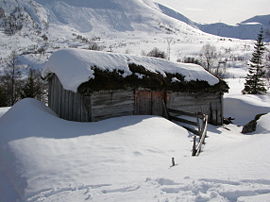
. The Viksdalen valley is located in Gaular.
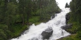
Gaular is sometimes referred to as Fosselandet (the land of the waterfalls) because it is home to 28 large and small waterfalls.
General information
Indre Holmedal was established as a municipality on 1 January 1838 (see formannskapsdistriktFormannskapsdistrikt
Formannskapsdistrikt was the name for a Norwegian local self-government districts put into force in 1838. This system of municipality was created in a bill approved by the Storting and signed into law by King Carl Johan on 14 January 1837...
). The original municipality was identical to the Indre Holmedal parish
Church of Norway
The Church of Norway is the state church of Norway, established after the Lutheran reformation in Denmark-Norway in 1536-1537 broke the ties to the Holy See. The church confesses the Lutheran Christian faith...
(prestegjeld
Prestegjeld
A Prestegjeld is a geographic and administrative area of the Church of Norway roughly equivalent to a parish. A prestegjeld can consist of one or many congregations...
) with the sub-parishes (sokn) of Bygstad, Sande
Sande, Sogn og Fjordane
Sande is the administrative centre of the municipality of Gaular in Sogn og Fjordane county, Norway. It is located along the Gaula River, about from where the river meets the Dalsfjorden. The village of Sande has a population of 637.The Førde Airport, Bringeland is located about north of...
, and Vik (Viksdalen). In 1912, the name of the municipality was changed to Gaular. On 1 January 1990, parts of the Hestad area were transferred from Fjaler
Fjaler
Fjaler is a municipality in the county of Sogn og Fjordane, Norway. It is located in the traditional district of Sunnfjord. The administrative centre is the village of Dale. Other places in Fjaler include Flekke and Espedal....
to Gaular.
Name
The name (Old NorseOld Norse
Old Norse is a North Germanic language that was spoken by inhabitants of Scandinavia and inhabitants of their overseas settlements during the Viking Age, until about 1300....
Gaular) is derived from the name of the river Gaula. The old name was revived in 1912, until then the name of the municipality was Indre Holmedal.
Coat-of-arms
The coat-of-armsCoat of arms
A coat of arms is a unique heraldic design on a shield or escutcheon or on a surcoat or tabard used to cover and protect armour and to identify the wearer. Thus the term is often stated as "coat-armour", because it was anciently displayed on the front of a coat of cloth...
is from modern times (1992). The silver line represents the Gaula River.
Churches
The Church of NorwayChurch of Norway
The Church of Norway is the state church of Norway, established after the Lutheran reformation in Denmark-Norway in 1536-1537 broke the ties to the Holy See. The church confesses the Lutheran Christian faith...
has four churches within the municipality of Gaular. It is part of the Diocese of Bjørgvin
Diocese of Bjørgvin
Bjørgvin Diocese is a diocese in the Church of Norway. It covers churches located in the counties of Hordaland and Sogn og Fjordane. The cathedral city is Bergen. Bergen Cathedral, formerly the Church of Saint Olaf, serves as the seat of the presiding Bishop...
and the Rural Deanery
Deanery
A Deanery is an ecclesiastical entity in both the Roman Catholic Church and the Church of England. A deanery is either the jurisdiction or residence of a Dean.- Catholic usage :...
(Prosti) of Sunnfjord
Sunnfjord
Sunnfjord is a traditional district in Western Norway located in Sogn og Fjordane county. It includes the municipalities of Askvoll, Fjaler, Flora, Førde, Gaular, Jølster, Naustdal, and the southernmost parts of Bremanger...
.
| Parish (Prestegjeld) | Sub-Parish (Sokn) | Church Name | Year Built | Location of the Church |
|---|---|---|---|---|
| Gaular Parish | Bygstad | Bygstad kyrkje | 1845 | Bygstad |
| Sande | Sande kyrkje | 1864 | Sande Sande, Sogn og Fjordane Sande is the administrative centre of the municipality of Gaular in Sogn og Fjordane county, Norway. It is located along the Gaula River, about from where the river meets the Dalsfjorden. The village of Sande has a population of 637.The Førde Airport, Bringeland is located about north of... |
|
| Hestad gamle kapell | 1805 | Hestad | ||
| Viksdalen | Viksdalen kyrkje | 1848 | Vik |
Government
All municipalities in Norway, including Gaular, are responsible for primary educationPrimary education
A primary school is an institution in which children receive the first stage of compulsory education known as primary or elementary education. Primary school is the preferred term in the United Kingdom and many Commonwealth Nations, and in most publications of the United Nations Educational,...
(through 10th grade), outpatient health services
Health care
Health care is the diagnosis, treatment, and prevention of disease, illness, injury, and other physical and mental impairments in humans. Health care is delivered by practitioners in medicine, chiropractic, dentistry, nursing, pharmacy, allied health, and other care providers...
, senior citizen
Old age
Old age consists of ages nearing or surpassing the average life span of human beings, and thus the end of the human life cycle...
services, unemployment
Unemployment
Unemployment , as defined by the International Labour Organization, occurs when people are without jobs and they have actively sought work within the past four weeks...
and other social services
Social work
Social Work is a professional and academic discipline that seeks to improve the quality of life and wellbeing of an individual, group, or community by intervening through research, policy, community organizing, direct practice, and teaching on behalf of those afflicted with poverty or any real or...
, zoning
Zoning
Zoning is a device of land use planning used by local governments in most developed countries. The word is derived from the practice of designating permitted uses of land based on mapped zones which separate one set of land uses from another...
, economic development
Economic development
Economic development generally refers to the sustained, concerted actions of policymakers and communities that promote the standard of living and economic health of a specific area...
, and municipal road
Road
A road is a thoroughfare, route, or way on land between two places, which typically has been paved or otherwise improved to allow travel by some conveyance, including a horse, cart, or motor vehicle. Roads consist of one, or sometimes two, roadways each with one or more lanes and also any...
s. The municipality is governed by a municipal council of elected representatives, which in turn elect a mayor
Mayor
In many countries, a Mayor is the highest ranking officer in the municipal government of a town or a large urban city....
.
Municipal council
The municipal council (Kommunestyre) of Gaular is made up of 21 representatives that are elected to every four years. For 2007–2011, the partyPolitical party
A political party is a political organization that typically seeks to influence government policy, usually by nominating their own candidates and trying to seat them in political office. Parties participate in electoral campaigns, educational outreach or protest actions...
breakdown is as follows:
Mayor
The mayorMayor
In many countries, a Mayor is the highest ranking officer in the municipal government of a town or a large urban city....
(ordførar) of a municipality in Norway is a representative of the majority party of the municipal council who is elected to lead the council. Jenny Følling of the Centre Party
Centre Party (Norway)
The Centre Party is a centrist and agrarian political party in Norway, founded in 1920. The Centre Party's policy is not based on any of the major ideologies of the 19th and 20th century, but has a focus on maintaining decentralised economic development and political decision-making.From its...
(Senterpartiet) was elected mayor for the 2007-2011 term.
Geography
Gaular is located in the central part of Sogn og Fjordane county. It is bordered to the north by the municipalities of AskvollAskvoll
is a municipality in the county of Sogn og Fjordane, Norway. It is located in the traditional district of Sunnfjord. The administrative centre is the village of Askvoll....
and Førde
Førde
Førde is a municipality in the county of Sogn og Fjordane, Norway. It is located in the traditional district of Sunnfjord. The administrative center is the town of Førde which in 2010 had 12,035 inhabitants. The historic village of Bruland is located just east of the town of Førde...
, to the east by Balestrand
Balestrand
Balestrand is a municipality in the county of Sogn og Fjordane, Norway. It is located in the traditional district of Sogn. The administrative center is the village of Balestrand....
, to the south by Høyanger
Høyanger
is a municipality in the county of Sogn og Fjordane, Norway. It is located in the traditional district of Sogn. The administrative center is the village of Høyanger, which has 2177 inhabitants . Other villages in Høyanger include Lavik, Kyrkjebø, Austreim, and Vadheim...
, and to the west by Fjaler
Fjaler
Fjaler is a municipality in the county of Sogn og Fjordane, Norway. It is located in the traditional district of Sunnfjord. The administrative centre is the village of Dale. Other places in Fjaler include Flekke and Espedal....
.
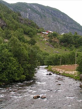
The Gaula River flows west through the municipality and empties into the Dalsfjorden
Dalsfjorden (Sunnfjord)
Dalsfjorden is a fjord in Sogn og Fjordane county, Norway. It is located between the municipalities of Askvoll, Fjaler, and Gaular. The fjord is about long and it is generally about wide....
near Bygstad.
Transportation
The E39European route E39
E 39 is the designation of a 1330 km long north-south road in Norway and Denmark, running from Klett just south of Trondheim to Aalborg, via Orkanger, Vinjeøra, Halsa ... Straumsnes, Krifast, Batnfjordsøra, Molde ... Vestnes, Skodje, Ålesund ... Volda ... Nordfjordeid ... Sandane, Førde,...
highway runs through the centre of Sande south to Bergen
Bergen
Bergen is the second largest city in Norway with a population of as of , . Bergen is the administrative centre of Hordaland county. Greater Bergen or Bergen Metropolitan Area as defined by Statistics Norway, has a population of as of , ....
, a distance of 150 kilometres (93.2 mi) (with a ferry
Ferry
A ferry is a form of transportation, usually a boat, but sometimes a ship, used to carry primarily passengers, and sometimes vehicles and cargo as well, across a body of water. Most ferries operate on regular, frequent, return services...
from Lavik
Lavik
Lavik is a village and former municipality in Sogn og Fjordane county in Norway. It is located in the eastern part of the present-day municipality of Høyanger...
to Oppedal). Førde Airport, Bringeland
Førde Airport, Bringeland
Førde Airport, Bringeland is located in the municipality of Gaular in Sogn og Fjordane county, Norway. The airport is at Bringelandsåsen, about east of the end of the Dalsfjorden at an elevation of above sea level....
(ENBL) is located at Bringelandsåsen in the municipality.
The Salmon Stairs
William T. Potts from Coreen Castle in IrelandIreland
Ireland is an island to the northwest of continental Europe. It is the third-largest island in Europe and the twentieth-largest island on Earth...
initiated the building of the stairs, which were completed in 1871, in return for an agreement made with the farmers that had 25 years of free fishing. The salmon stairs at Osen in Bygstad are the oldest in the world. The stairs consist of 17 pools/stages and has height of around 11 metres (36.1 ft). It is very effective as the salmon are forced to make their way up the stair construction, due to the current below the falls.
National Tourist Road
Riksvei 13 (Rv13) is one of 18 national tourist roads in Norway because of the nearby waterfalls. From Førde, drivers start on a sightseeing journey with cultural attractions that date from the 19th century to the present day’s city environment. The districts of Holsen and Haukedalen are typical of Western Norwegian farming communities that have created a picturesque cultivated landscape.Rørvik Mountain, the trail with the fascinating stone wall
Stone wall
Stone walls are a kind of masonry construction which have been made for thousands of years. First they were constructed by farmers and primitive people by piling loose field stones in what is called a dry stone wall, then later with the use of mortar and plaster especially in the construction of...
s and a marvellous view over Haukedalen. Along Råheimsdalen and Eldalen to the Gaularfjell mountains, you will see a marvellous waterfall landscape that has been landscaped with paths for visitors. From the top of Gaularfjell mountains, hairpin bends wind down to the Vetlefjorden, an arm of the Sognefjord
Sognefjord
The Sognefjord is the largest fjord in Norway, and the second longest in the world. Located in Sogn og Fjordane county, it stretches inland to the small village of Skjolden...
. The breathtaking contrasts of steep mountainsides, winding roads, and waterfalls are characteristic of Western Norway’s exceptional scenery.