
.gif)
Hurricane Javier (2004)
Encyclopedia
Hurricane Javier was the tenth named storm and the sixth and final hurricane of the 2004 Pacific hurricane season
. Javier was also the strongest hurricane of the 2004 season, with 150 mph (240 km/h) winds and a central pressure of 930 millibars. However, because of high wind shear
in the East Pacific, Javier weakened rapidly before making landfall in Baja California
as a tropical depression. The remnants of the storm then continued moving northeast through the Southwestern United States
. Javier caused no direct fatalities, and the damage in Mexico
and the United States
was minimal.
on August 29. The disturbance crossed the Atlantic Ocean
without further development due to unfavorable conditions. The tropical wave
then combined with another low pressure system near the Leeward Islands
and the two systems continued to move westward across the Caribbean Sea
. The storm crossed Central America
on September 9 where it gained more convection. On September 10, the disturbance became Tropical Depression 13-E at 1800 UTC. The next day, it strengthened into Tropical Storm Javier.
Weak wind shear
allowed Javier to reach hurricane strength on September 12. Then the storm moved slowly to the west and northwest around a subtropical ridge that was centered over Mexico
. Javier then underwent rapid intensification as the storm reached a peak intensity of 150 mph (240 km/h) and a central pressure of 930 millibars. These numbers qualified it as a Category 4 hurricane on the Saffir-Simpson Hurricane Scale
and made it the strongest tropical cyclone of the 2004 Pacific hurricane season
.
Javier then developed a concentric eyewall before weakening to a Category 3 storm. Javier maintained Category 3 status for three days before encountering cooler waters which further weakened the storm. Javier then turned northward and then northeastward before making landfall in Baja California
as a tropical depression on September 19. The depression moved over Guaymas, Sonora
, before losing tropical characteristics. The remnants of Javier then moved over the rest of Mexico
and the Southwestern United States
.
. The rapid intensification was also difficult to forecast compared to average forecast errors in a ten year period. Mexican officials began issuing tropical storm watches on September 15 as Javier paralleled the west coast of Mexico
. The warnings for western mainland Mexico
were then dropped as the storm did not recurve as predicted. However, more tropical storm warnings were issued for Baja California
and northwestern Mexico
as Javier was located 300 kilometres (186 mi) southwest of Baja California
. Forecasters predicted that Javier would bring a storm surge
of 1–3 feet, (0.3–1 meters)rainfall of 3-6 inches (7.6-15.2 cm), and strong rip currents. The National Hurricane Center
, predicted that Javier will parallel the Baja California
coastline according to their forecast models and recurve as a weak storm and dissipate over the Southwestern United States
.
On September 18, Mexican officials discontinued the warnings for Baja California
when Javier weakened to a tropical depression before making landfall.
 Winds up to tropical storm force were reported by ships at sea. On land, the storm dropped 3.14 inches (80 mm) of rain in Bacanuchi, Mexico
. Javier's flooding rains damaged portions of highway 1 near Vizcaino
and three fishermen were reported missing when their ship was lost during the storm. In addition, oil prices began to climb when Javier passed through the area. However, overall damage in Baja California
was minimal.
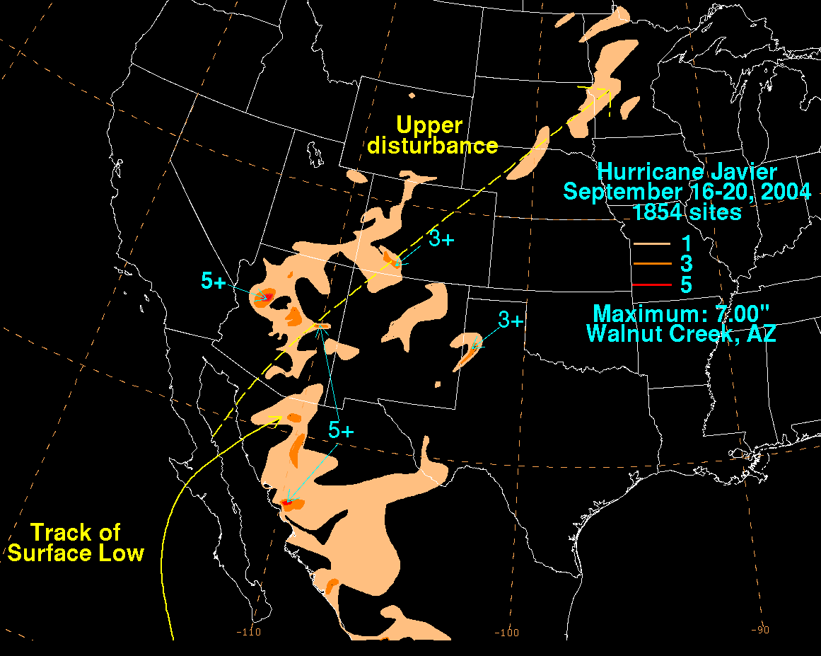
In Arizona
, the remnants of Javier dropped widespread, light to moderate rainfall, improving topsoil moisture and greatly affecting a prolonged drought in the Southwestern United States
. Maximum rainfall in the state reached 7 in (177.8 mm) in Walnut Creek. In Tucson, the airport received rainfall of 0.37 inches (93 mm) while the University of Arizona
reported 0.89 inches (26 mm) of rain. Lightning
and rain from Javier delayed the University of Arizona Wildcats football game against the Wisconsin Badgers for 88 minutes late in the second quarter, and flooding closed several roads. Grand Canyon, Arizona received 3.3 inches (83.8 mm) of rain, exactly one fifth of its yearly average. The remnants of Javier also dropped 1-3 inches of rain across Utah
, Colorado
, New Mexico
, Texas
and the upper Midwest. In terms of point maxima, Javier is the rainiest tropical cyclone on record in the period 1972 — 2008 in Wyoming
and North Dakota
.
2004 Pacific hurricane season
The 2004 Pacific hurricane season officially started on May 15, 2004 in the eastern Pacific, and on June 1, 2004 in the central Pacific, and lasted until November 30, 2004...
. Javier was also the strongest hurricane of the 2004 season, with 150 mph (240 km/h) winds and a central pressure of 930 millibars. However, because of high wind shear
Wind shear
Wind shear, sometimes referred to as windshear or wind gradient, is a difference in wind speed and direction over a relatively short distance in the atmosphere...
in the East Pacific, Javier weakened rapidly before making landfall in Baja California
Baja California
Baja California officially Estado Libre y Soberano de Baja California is one of the 31 states which, with the Federal District, comprise the 32 Federal Entities of Mexico. It is both the northernmost and westernmost state of Mexico. Before becoming a state in 1953, the area was known as the North...
as a tropical depression. The remnants of the storm then continued moving northeast through the Southwestern United States
Southwestern United States
The Southwestern United States is a region defined in different ways by different sources. Broad definitions include nearly a quarter of the United States, including Arizona, California, Colorado, Nevada, New Mexico, Oklahoma, Texas and Utah...
. Javier caused no direct fatalities, and the damage in Mexico
Mexico
The United Mexican States , commonly known as Mexico , is a federal constitutional republic in North America. It is bordered on the north by the United States; on the south and west by the Pacific Ocean; on the southeast by Guatemala, Belize, and the Caribbean Sea; and on the east by the Gulf of...
and the United States
United States
The United States of America is a federal constitutional republic comprising fifty states and a federal district...
was minimal.
Meteorological history
The origins of Javier was from a tropical wave that moved off the coast of AfricaAfrica
Africa is the world's second largest and second most populous continent, after Asia. At about 30.2 million km² including adjacent islands, it covers 6% of the Earth's total surface area and 20.4% of the total land area...
on August 29. The disturbance crossed the Atlantic Ocean
Atlantic Ocean
The Atlantic Ocean is the second-largest of the world's oceanic divisions. With a total area of about , it covers approximately 20% of the Earth's surface and about 26% of its water surface area...
without further development due to unfavorable conditions. The tropical wave
Tropical wave
Tropical waves, easterly waves, or tropical easterly waves, also known as African easterly waves in the Atlantic region, are a type of atmospheric trough, an elongated area of relatively low air pressure, oriented north to south, which move from east to west across the tropics causing areas of...
then combined with another low pressure system near the Leeward Islands
Leeward Islands
The Leeward Islands are a group of islands in the West Indies. They are the northern islands of the Lesser Antilles chain. As a group they start east of Puerto Rico and reach southward to Dominica. They are situated where the northeastern Caribbean Sea meets the western Atlantic Ocean...
and the two systems continued to move westward across the Caribbean Sea
Caribbean Sea
The Caribbean Sea is a sea of the Atlantic Ocean located in the tropics of the Western hemisphere. It is bounded by Mexico and Central America to the west and southwest, to the north by the Greater Antilles, and to the east by the Lesser Antilles....
. The storm crossed Central America
Central America
Central America is the central geographic region of the Americas. It is the southernmost, isthmian portion of the North American continent, which connects with South America on the southeast. When considered part of the unified continental model, it is considered a subcontinent...
on September 9 where it gained more convection. On September 10, the disturbance became Tropical Depression 13-E at 1800 UTC. The next day, it strengthened into Tropical Storm Javier.
Weak wind shear
Wind shear
Wind shear, sometimes referred to as windshear or wind gradient, is a difference in wind speed and direction over a relatively short distance in the atmosphere...
allowed Javier to reach hurricane strength on September 12. Then the storm moved slowly to the west and northwest around a subtropical ridge that was centered over Mexico
Mexico
The United Mexican States , commonly known as Mexico , is a federal constitutional republic in North America. It is bordered on the north by the United States; on the south and west by the Pacific Ocean; on the southeast by Guatemala, Belize, and the Caribbean Sea; and on the east by the Gulf of...
. Javier then underwent rapid intensification as the storm reached a peak intensity of 150 mph (240 km/h) and a central pressure of 930 millibars. These numbers qualified it as a Category 4 hurricane on the Saffir-Simpson Hurricane Scale
Saffir-Simpson Hurricane Scale
The Saffir–Simpson Hurricane Scale , or the Saffir–Simpson Hurricane Wind Scale , classifies hurricanes — Western Hemisphere tropical cyclones that exceed the intensities of tropical depressions and tropical storms — into five categories distinguished by the intensities of their sustained winds...
and made it the strongest tropical cyclone of the 2004 Pacific hurricane season
2004 Pacific hurricane season
The 2004 Pacific hurricane season officially started on May 15, 2004 in the eastern Pacific, and on June 1, 2004 in the central Pacific, and lasted until November 30, 2004...
.
Javier then developed a concentric eyewall before weakening to a Category 3 storm. Javier maintained Category 3 status for three days before encountering cooler waters which further weakened the storm. Javier then turned northward and then northeastward before making landfall in Baja California
Baja California
Baja California officially Estado Libre y Soberano de Baja California is one of the 31 states which, with the Federal District, comprise the 32 Federal Entities of Mexico. It is both the northernmost and westernmost state of Mexico. Before becoming a state in 1953, the area was known as the North...
as a tropical depression on September 19. The depression moved over Guaymas, Sonora
Guaymas
Guaymas is a city and municipality located in the southwest part of the state of Sonora in northwestern Mexico. The city is located 117 km south of the state capital of Hermosillo, and 242 miles from the U.S. border, and is the principal port for the state. The municipality is located in the...
, before losing tropical characteristics. The remnants of Javier then moved over the rest of Mexico
Mexico
The United Mexican States , commonly known as Mexico , is a federal constitutional republic in North America. It is bordered on the north by the United States; on the south and west by the Pacific Ocean; on the southeast by Guatemala, Belize, and the Caribbean Sea; and on the east by the Gulf of...
and the Southwestern United States
Southwestern United States
The Southwestern United States is a region defined in different ways by different sources. Broad definitions include nearly a quarter of the United States, including Arizona, California, Colorado, Nevada, New Mexico, Oklahoma, Texas and Utah...
.
Preparations
Javier's strength was difficult to forecast. In its formation stages many of the forecast models gave out a complex suggestions of where the storm should go. One of the models forecast the storm to move west for a couple of days and then stall offshore and then turn east and hit western GuatemalaGuatemala
Guatemala is a country in Central America bordered by Mexico to the north and west, the Pacific Ocean to the southwest, Belize to the northeast, the Caribbean to the east, and Honduras and El Salvador to the southeast...
. The rapid intensification was also difficult to forecast compared to average forecast errors in a ten year period. Mexican officials began issuing tropical storm watches on September 15 as Javier paralleled the west coast of Mexico
Mexico
The United Mexican States , commonly known as Mexico , is a federal constitutional republic in North America. It is bordered on the north by the United States; on the south and west by the Pacific Ocean; on the southeast by Guatemala, Belize, and the Caribbean Sea; and on the east by the Gulf of...
. The warnings for western mainland Mexico
Mexico
The United Mexican States , commonly known as Mexico , is a federal constitutional republic in North America. It is bordered on the north by the United States; on the south and west by the Pacific Ocean; on the southeast by Guatemala, Belize, and the Caribbean Sea; and on the east by the Gulf of...
were then dropped as the storm did not recurve as predicted. However, more tropical storm warnings were issued for Baja California
Baja California
Baja California officially Estado Libre y Soberano de Baja California is one of the 31 states which, with the Federal District, comprise the 32 Federal Entities of Mexico. It is both the northernmost and westernmost state of Mexico. Before becoming a state in 1953, the area was known as the North...
and northwestern Mexico
Mexico
The United Mexican States , commonly known as Mexico , is a federal constitutional republic in North America. It is bordered on the north by the United States; on the south and west by the Pacific Ocean; on the southeast by Guatemala, Belize, and the Caribbean Sea; and on the east by the Gulf of...
as Javier was located 300 kilometres (186 mi) southwest of Baja California
Baja California
Baja California officially Estado Libre y Soberano de Baja California is one of the 31 states which, with the Federal District, comprise the 32 Federal Entities of Mexico. It is both the northernmost and westernmost state of Mexico. Before becoming a state in 1953, the area was known as the North...
. Forecasters predicted that Javier would bring a storm surge
Storm surge
A storm surge is an offshore rise of water associated with a low pressure weather system, typically tropical cyclones and strong extratropical cyclones. Storm surges are caused primarily by high winds pushing on the ocean's surface. The wind causes the water to pile up higher than the ordinary sea...
of 1–3 feet, (0.3–1 meters)rainfall of 3-6 inches (7.6-15.2 cm), and strong rip currents. The National Hurricane Center
National Hurricane Center
The National Hurricane Center , located at Florida International University in Miami, Florida, is the division of the National Weather Service responsible for tracking and predicting weather systems within the tropics between the Prime Meridian and the 140th meridian west poleward to the 30th...
, predicted that Javier will parallel the Baja California
Baja California
Baja California officially Estado Libre y Soberano de Baja California is one of the 31 states which, with the Federal District, comprise the 32 Federal Entities of Mexico. It is both the northernmost and westernmost state of Mexico. Before becoming a state in 1953, the area was known as the North...
coastline according to their forecast models and recurve as a weak storm and dissipate over the Southwestern United States
Southwestern United States
The Southwestern United States is a region defined in different ways by different sources. Broad definitions include nearly a quarter of the United States, including Arizona, California, Colorado, Nevada, New Mexico, Oklahoma, Texas and Utah...
.
On September 18, Mexican officials discontinued the warnings for Baja California
Baja California
Baja California officially Estado Libre y Soberano de Baja California is one of the 31 states which, with the Federal District, comprise the 32 Federal Entities of Mexico. It is both the northernmost and westernmost state of Mexico. Before becoming a state in 1953, the area was known as the North...
when Javier weakened to a tropical depression before making landfall.
Impact
Mexico
The United Mexican States , commonly known as Mexico , is a federal constitutional republic in North America. It is bordered on the north by the United States; on the south and west by the Pacific Ocean; on the southeast by Guatemala, Belize, and the Caribbean Sea; and on the east by the Gulf of...
. Javier's flooding rains damaged portions of highway 1 near Vizcaino
Vizcaino
Vizcaino is the Spanish term to design a person natural of Biscay . It is a relatively common surname. It may refer to:*A native of Biscay , in Spanish language...
and three fishermen were reported missing when their ship was lost during the storm. In addition, oil prices began to climb when Javier passed through the area. However, overall damage in Baja California
Baja California
Baja California officially Estado Libre y Soberano de Baja California is one of the 31 states which, with the Federal District, comprise the 32 Federal Entities of Mexico. It is both the northernmost and westernmost state of Mexico. Before becoming a state in 1953, the area was known as the North...
was minimal.
In Arizona
Arizona
Arizona ; is a state located in the southwestern region of the United States. It is also part of the western United States and the mountain west. The capital and largest city is Phoenix...
, the remnants of Javier dropped widespread, light to moderate rainfall, improving topsoil moisture and greatly affecting a prolonged drought in the Southwestern United States
Southwestern United States
The Southwestern United States is a region defined in different ways by different sources. Broad definitions include nearly a quarter of the United States, including Arizona, California, Colorado, Nevada, New Mexico, Oklahoma, Texas and Utah...
. Maximum rainfall in the state reached 7 in (177.8 mm) in Walnut Creek. In Tucson, the airport received rainfall of 0.37 inches (93 mm) while the University of Arizona
University of Arizona
The University of Arizona is a land-grant and space-grant public institution of higher education and research located in Tucson, Arizona, United States. The University of Arizona was the first university in the state of Arizona, founded in 1885...
reported 0.89 inches (26 mm) of rain. Lightning
Lightning
Lightning is an atmospheric electrostatic discharge accompanied by thunder, which typically occurs during thunderstorms, and sometimes during volcanic eruptions or dust storms...
and rain from Javier delayed the University of Arizona Wildcats football game against the Wisconsin Badgers for 88 minutes late in the second quarter, and flooding closed several roads. Grand Canyon, Arizona received 3.3 inches (83.8 mm) of rain, exactly one fifth of its yearly average. The remnants of Javier also dropped 1-3 inches of rain across Utah
Utah
Utah is a state in the Western United States. It was the 45th state to join the Union, on January 4, 1896. Approximately 80% of Utah's 2,763,885 people live along the Wasatch Front, centering on Salt Lake City. This leaves vast expanses of the state nearly uninhabited, making the population the...
, Colorado
Colorado
Colorado is a U.S. state that encompasses much of the Rocky Mountains as well as the northeastern portion of the Colorado Plateau and the western edge of the Great Plains...
, New Mexico
New Mexico
New Mexico is a state located in the southwest and western regions of the United States. New Mexico is also usually considered one of the Mountain States. With a population density of 16 per square mile, New Mexico is the sixth-most sparsely inhabited U.S...
, Texas
Texas
Texas is the second largest U.S. state by both area and population, and the largest state by area in the contiguous United States.The name, based on the Caddo word "Tejas" meaning "friends" or "allies", was applied by the Spanish to the Caddo themselves and to the region of their settlement in...
and the upper Midwest. In terms of point maxima, Javier is the rainiest tropical cyclone on record in the period 1972 — 2008 in Wyoming
Wyoming
Wyoming is a state in the mountain region of the Western United States. The western two thirds of the state is covered mostly with the mountain ranges and rangelands in the foothills of the Eastern Rocky Mountains, while the eastern third of the state is high elevation prairie known as the High...
and North Dakota
North Dakota
North Dakota is a state located in the Midwestern region of the United States of America, along the Canadian border. The state is bordered by Canada to the north, Minnesota to the east, South Dakota to the south and Montana to the west. North Dakota is the 19th-largest state by area in the U.S....
.
See also
- Tropical cycloneTropical cycloneA tropical cyclone is a storm system characterized by a large low-pressure center and numerous thunderstorms that produce strong winds and heavy rain. Tropical cyclones strengthen when water evaporated from the ocean is released as the saturated air rises, resulting in condensation of water vapor...
- List of tropical cyclones
- List of named tropical cyclones
- List of wettest tropical cyclones in Arizona
- Timeline of the 2004 Pacific hurricane seasonTimeline of the 2004 Pacific hurricane seasonThe 2004 Pacific hurricane season had 17 tropical cyclones, of which 12 became named storms, 6 became hurricanes, and 3 became major hurricanes . This timeline documents all the storm formations, strengthening, weakening, landfalls, extratropical transitions, as well as dissipation...