
1970 Atlantic hurricane season
Encyclopedia
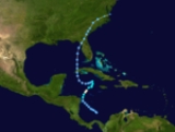
The 1970 Atlantic hurricane season officially began on June 1, 1970, and lasted until November 30, 1970. These dates conventionally delimit the period of each year when most tropical cyclone
s form in the Atlantic basin
. The season
was fairly average, with 10 total storms forming, of which five were hurricanes.
Notable storms of 1970 include Hurricane Celia
, which killed 20 and caused $930 million in damages as it passed over Cuba
and into Corpus Christi, Texas
; Tropical Storm Dorothy
, which killed 51, most in Martinique
; and a tropical depression
that was the wettest tropical cyclone in the history of Puerto Rico
.
in the middle of May. It gradually organized, and a tropical depression formed on May 17. In response to low shear aloft and warm water temperatures, the depression rapidly strengthened on May 20, becoming a storm early in the day and a hurricane by night. This did not last, and Alma weakened to a storm on May 21 and a depression the following day, mostly due to upper-level shear. The depression continued its general northward movement, with a brief jog to the west, and hit Cuba
on May 24 as a 30 mi/h tropical depression. As Alma crossed the eastern Gulf of Mexico
, it retained a very well defined circulation with an eye appearing on radar, but shear limited convection and strength. Alma crossed the Florida
coast on May 25, and became extratropical two days later over North Carolina
.
Alma was one of only three May hurricanes during the 20th century in the Atlantic basin
. The others were Able
in 1951 and an unnamed storm in 1908.
near Panama
joined a low-level vortex over the northwest Caribbean, becoming a tropical depression on July 19. The next day it organized over the Yucatan Channel
and became Tropical Storm Becky. Becky reached a peak of 65 mi/h winds over the eastern Gulf of Mexico, but upper level winds weakened it to a tropical depression prior its Florida Panhandle
landfall on July 22. The storm weakened further over land, and dissipated over western Kentucky
on the July 23.
, becoming a tropical depression on July 31 and a tropical storm on August 1. In the Gulf of Mexico, it rapidly became a major hurricane, but weakened steadily to an 85 mi/h hurricane. On August 3, it again rapidly strengthened to a major hurricane, this time reaching 125 mi/h winds prior to its Texas
landfall. Celia killed 20 due to extreme gusts, and caused $453.8 million in damage.
near the Bahamas on August 15. It moved northwestward for a day, followed by a northeast motion for another day, but it remained weak. On August 18, in combination with baroclinic processes, the depression strengthened rapidly to a 70 mi/h tropical storm prior to becoming extratropical on August 19 south of Newfoundland. Light rainfall was reported in South Carolina
, North Carolina
, and Virginia
; precipitation from the tropical storm peaked at 5.5 inches (139.7 mm) at the Marine Corps Air Station Cherry Point
in North Carolina.
on August 17. As it moved west-northwestward, it slowly intensified, and was upgraded to Tropical Storm Dorothy on August 19. On the following day, Dorothy attained its peak intensity with maximum sustained winds of 70 mi/h. Around that time, Dorothy crossed the island of Martinique
. After passing through the Lesser Antilles
, Dorothy moved under an upper-level cold-core
trough, which caused the storm to weaken. By August 23, Dorothy dissipated south of the Tiburon Peninsula
of Haiti
.
Throughout the Lesser Antilles, Dorothy produced high winds and heavy rainfall. On Martinique
, large amounts of precipitation resulted in flooding and mudslides, which in turn, caused bridge collapses and damage to homes. In addition, strong tropical storm force winds were also reported on the island. The storm destroyed 186 homes and left 700 people homeless. In addition, severe crop damage also occurred, especially to bananas and sugar cane. Flooding also occurred on Dominica
and Guadeloupe
, although effects were less severe. The exact death toll of Dorothy is unknown, although some sources claim that as many as 51 fatalities occurred. Dorothy also caused $34 million (1970 USD) in damage.
in the western Caribbean
on September 8. It moved northwestward without strengthening, but on September 10, as it moved into the Gulf of Mexico
, it rapidly strengthened into a tropical storm, and a hurricane six hours later. Hurricane Ella gradually intensified prior to landfall, reaching 125 mi/h winds on September 12 just before hitting the La Pesca/Soto la Marina area of the Mexican state of Tamaulipas
. Ella rapidly dissipated over land.
on September 16, and dissipated as a tropical cyclone the next day over northeastern Texas. The remnant low tracked slowly east-northeast across Arkansas before dissipating on September 19.
on October 1, and later stalled in the eastern Caribbean Sea. On October 8, the depression crossed over the eastern portion of the Dominican Republic
, and subsequently it accelerated to the northeast. It was declassified as a tropical cyclone on October 12, although its remnants persisted for another week before dissipating in the westerlies
near the Azores
.
The depression produced heavy rainfall in the Lesser Antilles, reaching 12 in (304.8 mm) on Barbados
; it left three deaths and moderate damage on the island. Another death was reported in the United States Virgin Islands
. Torrential rainfall on Puerto Rico inflicted heavy damage, totaling $65 million (1970 USD, $). The highest precipitation total was 41.68 in (1,058.7 mm) in Jayuya
, of which 17 in (431.8 mm) fell in a 24 hour period. Most of the damage can be attributed to damaged sugar cane and coffee crops. At least 18 people were killed on the island, and the system was considered one of the worst disasters in Puerto Rican history.
. The depression moved across the Gulf of Mexico without strengthening, and eventually hit the coast of Tampico, Tamaulipas, on October 4, where it dissipated shortly thereafter.
organized enough to be called a subtropical depression on October 12. The next day it reached storm intensity, and after a drift to the west, reached hurricane intensity on October 16. On October 16 it passed by Bermuda
, but damage was minimal. Baroclinic processes let the storm reach a peak of 100 mi/h winds before becoming extratropical on October 17.
from an area of non-tropical origin on October 20. It strengthened to a tropical storm the next day. It slowly moved eastward, gaining strength but losing size. When it became a hurricane on October 27, its hurricane-force wind field was only 5 mi (8 km) in diameter and its tropical storm force wind field was only 60 mi (96.6 km) in diameter. This compact cyclone became extratropical on October 28 after passing safely by the Azores.
in the 1974 Atlantic hurricane season
.
Tropical cyclone
A tropical cyclone is a storm system characterized by a large low-pressure center and numerous thunderstorms that produce strong winds and heavy rain. Tropical cyclones strengthen when water evaporated from the ocean is released as the saturated air rises, resulting in condensation of water vapor...
s form in the Atlantic basin
Atlantic Basin
The Atlantic Basin is the Atlantic Ocean.Atlantic Basin may also refer to:* Atlantic Basin Iron Works, an ironworks that operated in Brooklyn, New York, in the early to mid-20th century...
. The season
Atlantic hurricane season
The Atlantic hurricane season is the period in a year when hurricanes usually form in the Atlantic Ocean. Tropical cyclones in the North Atlantic are called hurricanes, tropical storms, or tropical depressions. In addition, there have been several storms over the years that have not been fully...
was fairly average, with 10 total storms forming, of which five were hurricanes.
Notable storms of 1970 include Hurricane Celia
Hurricane Celia
Hurricane Celia was the third named tropical cyclone, the second hurricane, and first major hurricane of the 1970 Atlantic hurricane season. Celia began as a tropical wave which formed off the eastern coast of Africa on July 23. The wave reached the eastern Caribbean Sea on July 28 and began to...
, which killed 20 and caused $930 million in damages as it passed over Cuba
Cuba
The Republic of Cuba is an island nation in the Caribbean. The nation of Cuba consists of the main island of Cuba, the Isla de la Juventud, and several archipelagos. Havana is the largest city in Cuba and the country's capital. Santiago de Cuba is the second largest city...
and into Corpus Christi, Texas
Corpus Christi, Texas
Corpus Christi is a coastal city in the South Texas region of the U.S. state of Texas. The county seat of Nueces County, it also extends into Aransas, Kleberg, and San Patricio counties. The MSA population in 2008 was 416,376. The population was 305,215 at the 2010 census making it the...
; Tropical Storm Dorothy
Tropical Storm Dorothy (1970)
Tropical Storm Dorothy was the deadliest tropical cyclone of the 1970 Atlantic hurricane season. The fourth named storm and fifth tropical storm or hurricane of the season, Dorothy developed on August 17 from a tropical wave to the east of the Lesser Antilles...
, which killed 51, most in Martinique
Martinique
Martinique is an island in the eastern Caribbean Sea, with a land area of . Like Guadeloupe, it is an overseas region of France, consisting of a single overseas department. To the northwest lies Dominica, to the south St Lucia, and to the southeast Barbados...
; and a tropical depression
Tropical Depression Nineteen (1970)
Tropical Depression Nineteen in 1970 was the wettest known tropical cyclone to affect the United States territory of Puerto Rico. The long-lived depression formed on September 24 just off the west coast of Africa, and for several days maintained a general westward track. It passed through the...
that was the wettest tropical cyclone in the history of Puerto Rico
Puerto Rico
Puerto Rico , officially the Commonwealth of Puerto Rico , is an unincorporated territory of the United States, located in the northeastern Caribbean, east of the Dominican Republic and west of both the United States Virgin Islands and the British Virgin Islands.Puerto Rico comprises an...
.
Hurricane Alma
An area of disturbed weather persisted over the southwestern Caribbean SeaCaribbean Sea
The Caribbean Sea is a sea of the Atlantic Ocean located in the tropics of the Western hemisphere. It is bounded by Mexico and Central America to the west and southwest, to the north by the Greater Antilles, and to the east by the Lesser Antilles....
in the middle of May. It gradually organized, and a tropical depression formed on May 17. In response to low shear aloft and warm water temperatures, the depression rapidly strengthened on May 20, becoming a storm early in the day and a hurricane by night. This did not last, and Alma weakened to a storm on May 21 and a depression the following day, mostly due to upper-level shear. The depression continued its general northward movement, with a brief jog to the west, and hit Cuba
Cuba
The Republic of Cuba is an island nation in the Caribbean. The nation of Cuba consists of the main island of Cuba, the Isla de la Juventud, and several archipelagos. Havana is the largest city in Cuba and the country's capital. Santiago de Cuba is the second largest city...
on May 24 as a 30 mi/h tropical depression. As Alma crossed the eastern Gulf of Mexico
Gulf of Mexico
The Gulf of Mexico is a partially landlocked ocean basin largely surrounded by the North American continent and the island of Cuba. It is bounded on the northeast, north and northwest by the Gulf Coast of the United States, on the southwest and south by Mexico, and on the southeast by Cuba. In...
, it retained a very well defined circulation with an eye appearing on radar, but shear limited convection and strength. Alma crossed the Florida
Florida
Florida is a state in the southeastern United States, located on the nation's Atlantic and Gulf coasts. It is bordered to the west by the Gulf of Mexico, to the north by Alabama and Georgia and to the east by the Atlantic Ocean. With a population of 18,801,310 as measured by the 2010 census, it...
coast on May 25, and became extratropical two days later over North Carolina
North Carolina
North Carolina is a state located in the southeastern United States. The state borders South Carolina and Georgia to the south, Tennessee to the west and Virginia to the north. North Carolina contains 100 counties. Its capital is Raleigh, and its largest city is Charlotte...
.
Alma was one of only three May hurricanes during the 20th century in the Atlantic basin
Atlantic Basin
The Atlantic Basin is the Atlantic Ocean.Atlantic Basin may also refer to:* Atlantic Basin Iron Works, an ironworks that operated in Brooklyn, New York, in the early to mid-20th century...
. The others were Able
Hurricane Able (1951)
Hurricane Able was the strongest recorded hurricane outside of the typical Atlantic hurricane season. The first tropical cyclone in 1951, Able developed from a trough of low pressure on May 15 about 300 miles south of Bermuda...
in 1951 and an unnamed storm in 1908.
Tropical Storm Becky
A rain system from the Intertropical Convergence ZoneIntertropical Convergence Zone
The Intertropical Convergence Zone , known by sailors as The Doldrums, is the area encircling the earth near the equator where winds originating in the northern and southern hemispheres come together....
near Panama
Panama
Panama , officially the Republic of Panama , is the southernmost country of Central America. Situated on the isthmus connecting North and South America, it is bordered by Costa Rica to the northwest, Colombia to the southeast, the Caribbean Sea to the north and the Pacific Ocean to the south. The...
joined a low-level vortex over the northwest Caribbean, becoming a tropical depression on July 19. The next day it organized over the Yucatan Channel
Yucatán Channel
The Yucatán Channel is a strait between Mexico and Cuba. It connects the Yucatán Basin of the Caribbean Sea with the Gulf of Mexico. The strait is across between Cape Catoche in Mexico and Cape San Antonio, Cuba and reaches a maximum depth of .-References:...
and became Tropical Storm Becky. Becky reached a peak of 65 mi/h winds over the eastern Gulf of Mexico, but upper level winds weakened it to a tropical depression prior its Florida Panhandle
Florida Panhandle
The Florida Panhandle, an informal, unofficial term for the northwestern part of Florida, is a strip of land roughly 200 miles long and 50 to 100 miles wide , lying between Alabama on the north and the west, Georgia also on the north, and the Gulf of Mexico to the south. Its eastern boundary is...
landfall on July 22. The storm weakened further over land, and dissipated over western Kentucky
Kentucky
The Commonwealth of Kentucky is a state located in the East Central United States of America. As classified by the United States Census Bureau, Kentucky is a Southern state, more specifically in the East South Central region. Kentucky is one of four U.S. states constituted as a commonwealth...
on the July 23.
Hurricane Celia
Hurricane Celia developed from a tropical wave moving through the CaribbeanCaribbean
The Caribbean is a crescent-shaped group of islands more than 2,000 miles long separating the Gulf of Mexico and the Caribbean Sea, to the west and south, from the Atlantic Ocean, to the east and north...
, becoming a tropical depression on July 31 and a tropical storm on August 1. In the Gulf of Mexico, it rapidly became a major hurricane, but weakened steadily to an 85 mi/h hurricane. On August 3, it again rapidly strengthened to a major hurricane, this time reaching 125 mi/h winds prior to its Texas
Texas
Texas is the second largest U.S. state by both area and population, and the largest state by area in the contiguous United States.The name, based on the Caddo word "Tejas" meaning "friends" or "allies", was applied by the Spanish to the Caddo themselves and to the region of their settlement in...
landfall. Celia killed 20 due to extreme gusts, and caused $453.8 million in damage.
Tropical Storm Four
A tropical depression formed in the western Atlantic OceanAtlantic Ocean
The Atlantic Ocean is the second-largest of the world's oceanic divisions. With a total area of about , it covers approximately 20% of the Earth's surface and about 26% of its water surface area...
near the Bahamas on August 15. It moved northwestward for a day, followed by a northeast motion for another day, but it remained weak. On August 18, in combination with baroclinic processes, the depression strengthened rapidly to a 70 mi/h tropical storm prior to becoming extratropical on August 19 south of Newfoundland. Light rainfall was reported in South Carolina
South Carolina
South Carolina is a state in the Deep South of the United States that borders Georgia to the south, North Carolina to the north, and the Atlantic Ocean to the east. Originally part of the Province of Carolina, the Province of South Carolina was one of the 13 colonies that declared independence...
, North Carolina
North Carolina
North Carolina is a state located in the southeastern United States. The state borders South Carolina and Georgia to the south, Tennessee to the west and Virginia to the north. North Carolina contains 100 counties. Its capital is Raleigh, and its largest city is Charlotte...
, and Virginia
Virginia
The Commonwealth of Virginia , is a U.S. state on the Atlantic Coast of the Southern United States. Virginia is nicknamed the "Old Dominion" and sometimes the "Mother of Presidents" after the eight U.S. presidents born there...
; precipitation from the tropical storm peaked at 5.5 inches (139.7 mm) at the Marine Corps Air Station Cherry Point
Marine Corps Air Station Cherry Point
Marine Corps Air Station Cherry Point or MCAS Cherry Point is a United States Marine Corps airfield located in Havelock, North Carolina, USA, in the eastern part of the state...
in North Carolina.
Tropical Storm Dorothy
A tropical wave led to a tropical depression beginning 500 miles (804.7 km) east of the Lesser AntillesLesser Antilles
The Lesser Antilles are a long, partly volcanic island arc in the Western Hemisphere. Most of its islands form the eastern boundary of the Caribbean Sea with the Atlantic Ocean, with the remainder located in the southern Caribbean just north of South America...
on August 17. As it moved west-northwestward, it slowly intensified, and was upgraded to Tropical Storm Dorothy on August 19. On the following day, Dorothy attained its peak intensity with maximum sustained winds of 70 mi/h. Around that time, Dorothy crossed the island of Martinique
Martinique
Martinique is an island in the eastern Caribbean Sea, with a land area of . Like Guadeloupe, it is an overseas region of France, consisting of a single overseas department. To the northwest lies Dominica, to the south St Lucia, and to the southeast Barbados...
. After passing through the Lesser Antilles
Lesser Antilles
The Lesser Antilles are a long, partly volcanic island arc in the Western Hemisphere. Most of its islands form the eastern boundary of the Caribbean Sea with the Atlantic Ocean, with the remainder located in the southern Caribbean just north of South America...
, Dorothy moved under an upper-level cold-core
Cold-core low
A cold-core low, also known as a cold low or cold-core cyclone, is a cyclone aloft which has an associated cold pool of air residing at high altitude within the Earth's troposphere. It is a low pressure system which strengthens with height in accordance with the thermal wind relationship. These...
trough, which caused the storm to weaken. By August 23, Dorothy dissipated south of the Tiburon Peninsula
Tiburon Peninsula
The Tiburon Peninsula , or simply "the Tiburon", is a region of Haiti encompassing all of Haiti's southern coast. It starts roughly at the southernmost of the Haiti-Dominican Republic border and extends westward near Cuba, forming a large headland. Four of Haiti's ten departments are located...
of Haiti
Haiti
Haiti , officially the Republic of Haiti , is a Caribbean country. It occupies the western, smaller portion of the island of Hispaniola, in the Greater Antillean archipelago, which it shares with the Dominican Republic. Ayiti was the indigenous Taíno or Amerindian name for the island...
.
Throughout the Lesser Antilles, Dorothy produced high winds and heavy rainfall. On Martinique
Martinique
Martinique is an island in the eastern Caribbean Sea, with a land area of . Like Guadeloupe, it is an overseas region of France, consisting of a single overseas department. To the northwest lies Dominica, to the south St Lucia, and to the southeast Barbados...
, large amounts of precipitation resulted in flooding and mudslides, which in turn, caused bridge collapses and damage to homes. In addition, strong tropical storm force winds were also reported on the island. The storm destroyed 186 homes and left 700 people homeless. In addition, severe crop damage also occurred, especially to bananas and sugar cane. Flooding also occurred on Dominica
Dominica
Dominica , officially the Commonwealth of Dominica, is an island nation in the Lesser Antilles region of the Caribbean Sea, south-southeast of Guadeloupe and northwest of Martinique. Its size is and the highest point in the country is Morne Diablotins, which has an elevation of . The Commonwealth...
and Guadeloupe
Guadeloupe
Guadeloupe is an archipelago located in the Leeward Islands, in the Lesser Antilles, with a land area of 1,628 square kilometres and a population of 400,000. It is the first overseas region of France, consisting of a single overseas department. As with the other overseas departments, Guadeloupe...
, although effects were less severe. The exact death toll of Dorothy is unknown, although some sources claim that as many as 51 fatalities occurred. Dorothy also caused $34 million (1970 USD) in damage.
Hurricane Ella
Hurricane Ella developed from a surface trough near the Swan IslandsSwan Islands, Honduras
The Swan Islands, or Islas Santanilla, are a chain of three islands located in the northwestern Caribbean Sea, approximately ninety miles off the coastline of Honduras, with a land area of .-Detailed location and features:...
in the western Caribbean
Caribbean
The Caribbean is a crescent-shaped group of islands more than 2,000 miles long separating the Gulf of Mexico and the Caribbean Sea, to the west and south, from the Atlantic Ocean, to the east and north...
on September 8. It moved northwestward without strengthening, but on September 10, as it moved into the Gulf of Mexico
Gulf of Mexico
The Gulf of Mexico is a partially landlocked ocean basin largely surrounded by the North American continent and the island of Cuba. It is bounded on the northeast, north and northwest by the Gulf Coast of the United States, on the southwest and south by Mexico, and on the southeast by Cuba. In...
, it rapidly strengthened into a tropical storm, and a hurricane six hours later. Hurricane Ella gradually intensified prior to landfall, reaching 125 mi/h winds on September 12 just before hitting the La Pesca/Soto la Marina area of the Mexican state of Tamaulipas
Tamaulipas
Tamaulipas officially Estado Libre y Soberano de Tamaulipas is one of the 31 states which, with the Federal District, comprise the 32 Federal Entities of Mexico. It is divided in 43 municipalities and its capital city is Ciudad Victoria. The capital city was named after Guadalupe Victoria, the...
. Ella rapidly dissipated over land.
Tropical Storm Felice
An upper level trough led to the formation of a tropical depression on September 12 over the southern Bahamas. Land interaction limited strength initially, but as it moved into the Gulf of Mexico, it was able to strengthen to a 70 mi/h tropical storm. Shortly after its peak Felice moved inland near High Island, TexasHigh Island, Texas
High Island is an unincorporated area located in the Bolivar Peninsula census-designated place, Galveston County, Texas, United States. The community is located in the extreme eastern part of the county on Bolivar Peninsula, less than one mile from Chambers County and less than two miles from...
on September 16, and dissipated as a tropical cyclone the next day over northeastern Texas. The remnant low tracked slowly east-northeast across Arkansas before dissipating on September 19.
Tropical Depression Nineteen
The long-lived depression formed on September 24 just off the west coast of Africa, and for several days maintained a general westward track. It passed through the Lesser AntillesLesser Antilles
The Lesser Antilles are a long, partly volcanic island arc in the Western Hemisphere. Most of its islands form the eastern boundary of the Caribbean Sea with the Atlantic Ocean, with the remainder located in the southern Caribbean just north of South America...
on October 1, and later stalled in the eastern Caribbean Sea. On October 8, the depression crossed over the eastern portion of the Dominican Republic
Dominican Republic
The Dominican Republic is a nation on the island of La Hispaniola, part of the Greater Antilles archipelago in the Caribbean region. The western third of the island is occupied by the nation of Haiti, making Hispaniola one of two Caribbean islands that are shared by two countries...
, and subsequently it accelerated to the northeast. It was declassified as a tropical cyclone on October 12, although its remnants persisted for another week before dissipating in the westerlies
Westerlies
The Westerlies, anti-trades, or Prevailing Westerlies, are the prevailing winds in the middle latitudes between 30 and 60 degrees latitude, blowing from the high pressure area in the horse latitudes towards the poles. These prevailing winds blow from the west to the east, and steer extratropical...
near the Azores
Azores
The Archipelago of the Azores is composed of nine volcanic islands situated in the middle of the North Atlantic Ocean, and is located about west from Lisbon and about east from the east coast of North America. The islands, and their economic exclusion zone, form the Autonomous Region of the...
.
The depression produced heavy rainfall in the Lesser Antilles, reaching 12 in (304.8 mm) on Barbados
Barbados
Barbados is an island country in the Lesser Antilles. It is in length and as much as in width, amounting to . It is situated in the western area of the North Atlantic and 100 kilometres east of the Windward Islands and the Caribbean Sea; therein, it is about east of the islands of Saint...
; it left three deaths and moderate damage on the island. Another death was reported in the United States Virgin Islands
United States Virgin Islands
The Virgin Islands of the United States are a group of islands in the Caribbean that are an insular area of the United States. The islands are geographically part of the Virgin Islands archipelago and are located in the Leeward Islands of the Lesser Antilles.The U.S...
. Torrential rainfall on Puerto Rico inflicted heavy damage, totaling $65 million (1970 USD, $). The highest precipitation total was 41.68 in (1,058.7 mm) in Jayuya
Jayuya, Puerto Rico
Jayuya is a municipality of Puerto Rico located in the mountainous center region of the island, north of Ponce; east of Utuado; and west of Ciales. Jayuya is spread over 18 wards and Jayuya Pueblo...
, of which 17 in (431.8 mm) fell in a 24 hour period. Most of the damage can be attributed to damaged sugar cane and coffee crops. At least 18 people were killed on the island, and the system was considered one of the worst disasters in Puerto Rican history.
Tropical Storm Greta
Tropical Storm Greta began quickly, forming as a tropical storm from a tropical wave over the Bahamas on September 26. Greta did not develop any further, and soon became disorganized, weakening to a tropical depression the next day as it crossed the Florida KeysFlorida Keys
The Florida Keys are a coral archipelago in southeast United States. They begin at the southeastern tip of the Florida peninsula, about south of Miami, and extend in a gentle arc south-southwest and then westward to Key West, the westernmost of the inhabited islands, and on to the uninhabited Dry...
. The depression moved across the Gulf of Mexico without strengthening, and eventually hit the coast of Tampico, Tamaulipas, on October 4, where it dissipated shortly thereafter.
Hurricane Nine
An elongated cold-core circulation north of Puerto RicoPuerto Rico
Puerto Rico , officially the Commonwealth of Puerto Rico , is an unincorporated territory of the United States, located in the northeastern Caribbean, east of the Dominican Republic and west of both the United States Virgin Islands and the British Virgin Islands.Puerto Rico comprises an...
organized enough to be called a subtropical depression on October 12. The next day it reached storm intensity, and after a drift to the west, reached hurricane intensity on October 16. On October 16 it passed by Bermuda
Bermuda
Bermuda is a British overseas territory in the North Atlantic Ocean. Located off the east coast of the United States, its nearest landmass is Cape Hatteras, North Carolina, about to the west-northwest. It is about south of Halifax, Nova Scotia, Canada, and northeast of Miami, Florida...
, but damage was minimal. Baroclinic processes let the storm reach a peak of 100 mi/h winds before becoming extratropical on October 17.
Hurricane Ten
A subtropical depression formed west of the AzoresAzores
The Archipelago of the Azores is composed of nine volcanic islands situated in the middle of the North Atlantic Ocean, and is located about west from Lisbon and about east from the east coast of North America. The islands, and their economic exclusion zone, form the Autonomous Region of the...
from an area of non-tropical origin on October 20. It strengthened to a tropical storm the next day. It slowly moved eastward, gaining strength but losing size. When it became a hurricane on October 27, its hurricane-force wind field was only 5 mi (8 km) in diameter and its tropical storm force wind field was only 60 mi (96.6 km) in diameter. This compact cyclone became extratropical on October 28 after passing safely by the Azores.
Storm names
The following names were used for named storms (tropical storms and hurricanes) that formed in the North Atlantic in 1970. A storm was named Felice for the first time in 1970. Names that were not assigned are marked in .
|
Retirement
The name Celia was later retired and replaced by CarmenHurricane Carmen
Hurricane Carmen was the most intense tropical cyclone of the 1974 Atlantic hurricane season. A destructive and widespread storm, Carmen originated as a tropical disturbance that emerged from Africa toward the end of August. The wave traveled westward, spawning a tropical depression east of the...
in the 1974 Atlantic hurricane season
1974 Atlantic hurricane season
The 1974 Atlantic hurricane season officially began on June 1, 1974, and lasted until November 30, 1974. These dates conventionally delimit the period of each year when most tropical cyclones form in the Atlantic basin...
.
See also
- List of Atlantic hurricanes
- List of Atlantic hurricane seasons
- 1970 Pacific hurricane season1970 Pacific hurricane seasonThe 1970 Pacific hurricane season began on May 15, 1970 in the east Pacific, and on June 1, 1970 in the central Pacific. It ended on November 30, 1970. These dates conventionally delimit the period of time when tropical cyclones form in the eastern Pacific Ocean.This season had an above average...
- 1970 Pacific typhoon season1970 Pacific typhoon seasonThe 1970 Pacific typhoon season has no official bounds; it ran year-round in 1970, but most tropical cyclones tend to form in the northwestern Pacific Ocean between June and December...
- 1970 North Indian Ocean cyclone season1970 North Indian Ocean cyclone seasonThe 1970 North Indian Ocean cyclone season had no bounds, but tropical cyclones in the North Indian Ocean tend to form between April and December, with peaks in May and November. The 1970 season saw a total of seven cyclonic storms, of which three developed into severe cyclonic storms...
- Southern Hemisphere tropical cyclone seasons: 1969–70, 1970–71