
.gif)
Hurricane Ignacio (2003)
Encyclopedia
Hurricane Ignacio was the latest-forming first hurricane of a Pacific hurricane
season since reliable satellite observation began in 1966. The ninth tropical storm of the 2003 Pacific hurricane season
, Ignacio developed out of a tropical wave
on August 22 a short distance off the coast of Mexico
. It was initially predicted to track out to sea and remain a weak tropical storm, though it unexpectedly organized rapidly to attain peak winds of 105 mph (165 km/h) on August 24 while located a short distance southeast of southern Baja California
. Land interaction weakened Ignacio to an 80 mph (130 km/h) hurricane by the time it made landfall
near La Paz
, and it dissipated on August 27 in the central region of the Baja California peninsula
.
The hurricane produced heavy rainfall in southern Baja California, killing two rescue works from floodwaters. Resort areas near the coast experienced minor effects, though further inland the damage was more severe. The impact of Ignacio was compounded by flooding from Hurricane Marty
a month later, with damage from the two hurricanes totaling about $1 billion (2003 USD, $1.1 billion 2006 USD).
exited the coast of Africa
on August 6. It moved westward across the Atlantic Ocean
without development, and entered the eastern Pacific Ocean
on August 16 after crossing Central America
. Cloudiness and convection
gradually increased along the wave axis and organized into a distinct area of disturbed weather on August 20 while located a short distance south of Manzanillo
, Mexico
. It slowly became better organized as it moved northwestward in an area favorable for continued development. With light vertical wind shear
and warm water temperatures
, the convection concentrated around a developing low-level circulation, and on August 22 it organized enough for the National Hurricane Center
to classify it as Tropical Depression Nine-E while it was located about 115 miles (185 km) west of the Mexico mainland or about 220 miles (345 km) southeast of the southern tip of the Baja California Peninsula
. With an anticyclone
located over the southwestern United States
and a ridge
extending southward into northwestern Mexico, the National Hurricane Center initially predicted the depression to track generally west-northwestward out to sea and reach peak winds of 50 mph (85 km/h).
The tropical depression moved slowly northwestward, with the slow motion persisting for its entire lifetime due to the storm being embedded within the weakness of a mid-level ridge to its north. Shortly after forming, the storm was located in a marginally favorable environment, with westerly wind shear and dry air approaching the depression and leaving the center of circulation exposed from the convection. However, the wind shear subsequently decreased, and early on August 23 the depression intensified into Tropical Storm Ignacio. The storm quickly organized and developed well-defined banding features and very well-organized upper-level outflow, and by late on August 23 a warm spot formed in the center of the convection. The warm spot organized into an intermittent eye feature
. Early on August 24, Ignacio attained hurricane status, the latest formation of the first hurricane of a season recorded in the East Pacific since reliable satellite observation began in 1966.
.jpg) Hurricane Ignacio continued to quickly intensify after becoming a hurricane, and reached peak winds of 105 mph (165 km/h) later on August 24 while located within 30 miles (48 km/h) off the coast of Baja California Sur
Hurricane Ignacio continued to quickly intensify after becoming a hurricane, and reached peak winds of 105 mph (165 km/h) later on August 24 while located within 30 miles (48 km/h) off the coast of Baja California Sur
. Upon reaching peak strength, the hurricane possessed a 12 mile (19 km) wide eye surrounded by very deep convection. The National Hurricane Center predicted it to attain major hurricane status and potentially reach significantly higher winds if the center remained over open water. However, it turned to the northwest and paralleled the Baja California Peninsula
a short distance offshore, resulting in a steady weakening trend due to its interaction with the high terrain. On August 25 Ignacio made landfall
just east of La Paz
with winds of 80 mph (130 km/h). It rapidly weakened over land, first deteriorating to a tropical storm 12 hours after landfall and later to a tropical depression about a day after moving ashore. Ignacio continued northwestward across the peninsula, and dissipated
on August 28 while located in northwestern Baja California Sur.
issued a tropical storm watch
from Santa Fe to La Paz
, with the watch upgraded to a warning nine hours later. The warning was extended on both coasts from Bahia Magdalena to San Evaristo the next day. About 48 hours before Ignacio made landfall, a hurricane warning was issued from Santa Fe to La Paz, and 21 hours later extended to Bahia Magdalena and San Evaristo. The government of Mexico also issued a tropical storm warning for the mainland from Atlana to Topolobampo
in the state of Sinaloa
.
The Civil Protection agency for the state of Baja California Sur ordered for the evacuation for 10,000 residents in flood-prone areas near La Paz
. Officials also moved 700 people in areas near rivers to shelters in Los Cabos
. 32 emergency shelters were set up in and around La Paz. Residents near the coast placed sandbag
s to protect their houses from potential flooding, and also stocked up on hurricane supplies. Police authorities were stationed in areas around Los Cabos to guard against price gouging
. Officials closed many schools and businesses throughout the area, and also shut down the area's primary airport in La Paz. About 500 people in Sinaloa
were evacuated, as well.
 Prior to developing, the precursor tropical disturbance dropped heavy rainfall and produced gusty winds, primarily from Zihuatanejo
in the state of Guerrero
to Manzanillo
in the state of Colima
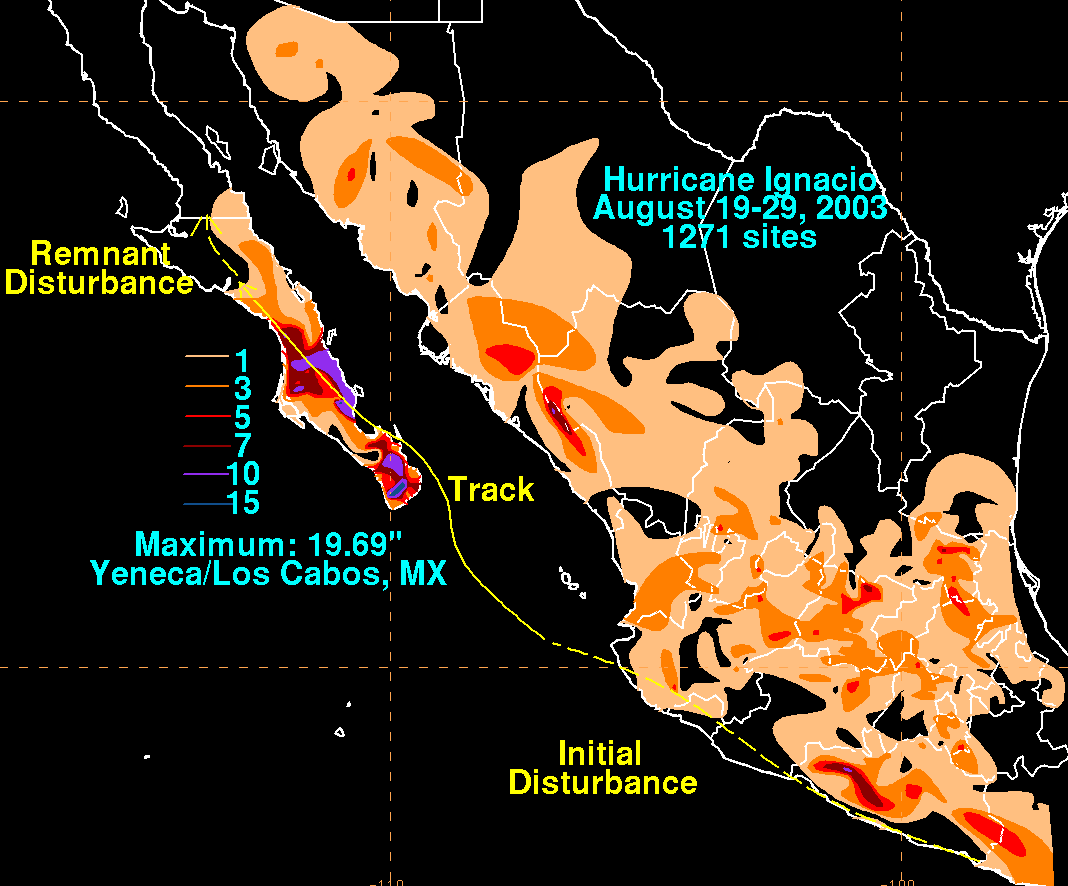
. The slow motion of Ignacio produced heavy rainfall across the southern portion of the Baja California Peninsula
, including a peak 24 hour total of 7.25 inches (184 mm) in Ciudad Constitución
. The National Hurricane Center
warned of rainfall totals of up to 20 inches (500 mm) in some localized areas, which did verify in Los Cabos. Ignacio produced strong waves which hit the eastern Baja California coastline. Swells
of 10 feet (3 m) in height in La Paz
closed the city's small port.
Hurricane force winds blew down trees, signs, and power lines in and around La Paz
, while closer to the beach the hurricane destroyed multiple beach huts. Rough surf in the harbor of La Paz sunk one fishing vessel and grounded four others. Efforts by the Mexican Navy
prevented an additional vessel and two cruise ships from being grounded. In Cabo San Lucas
, effects were minimal, amounting to light winds and rain of less than 2 inches (50 mm). The passage of the hurricane left citizens in Todos Santos
without power for around 24 hours. Heavy rainfall caused severe inland flooding, destroying bridges and multiple mudslides, some of which blocked roads. Flash flood
ing in desert inland areas washed out roads, causing the Mexican government to restrict traffic through much of the peninsula for up to a week after the storm. Many roads remained impassable for a month after the hurricane. The closed roads and the airport in La Paz and southern Baja California left some tourists stranded. The rainfall was welcome in some desert areas, where the moderate precipitation filled reservoirs. Two rescue workers died when they were swept away by the floodwaters. Six municipalities
in Baja California were declared disaster areas, and by four days after landfall, the Mexican government prepared emergency funds to meet the immediate needs of the affected citizens.
Heavy rainfall was also reported in Sinaloa
on the Mexican mainland. The remnants of Ignacio produced thunderstorm
activity in high terrain areas of central interior California
. Over 300 lightning
strikes from the remnant moisture was recorded in a one-hour period. The lightning caused 14 forest fires in Merced County
, resulting in a loss of power to over 3,500 customers in and around the Atwater
area.
Just a month after Ignacio, Hurricane Marty
passed through the area, causing additional damage to areas hit by Ignacio. The combined damage from the two hurricanes totaled about $1 billion (2003 USD, $1.1 billion 2006 USD), and the effects from the two storms left at least 50,000 homeless.
Pacific hurricane
A Pacific hurricane or tropical storm is a tropical cyclone that develops in the northeastern part of the Pacific Ocean. For organizational purposes, the northern Pacific Ocean is divided into three regions: the eastern, , central , and western...
season since reliable satellite observation began in 1966. The ninth tropical storm of the 2003 Pacific hurricane season
2003 Pacific hurricane season
The 2003 Pacific hurricane season produced an unusually large number of tropical cyclones which affected Mexico. The most notable cyclones the year were Hurricanes Ignacio and Marty, which killed 2 and 12 people in Mexico, respectively, and were collectively responsible for about...
, Ignacio developed out of a tropical wave
Tropical wave
Tropical waves, easterly waves, or tropical easterly waves, also known as African easterly waves in the Atlantic region, are a type of atmospheric trough, an elongated area of relatively low air pressure, oriented north to south, which move from east to west across the tropics causing areas of...
on August 22 a short distance off the coast of Mexico
Mexico
The United Mexican States , commonly known as Mexico , is a federal constitutional republic in North America. It is bordered on the north by the United States; on the south and west by the Pacific Ocean; on the southeast by Guatemala, Belize, and the Caribbean Sea; and on the east by the Gulf of...
. It was initially predicted to track out to sea and remain a weak tropical storm, though it unexpectedly organized rapidly to attain peak winds of 105 mph (165 km/h) on August 24 while located a short distance southeast of southern Baja California
Baja California Sur
Baja California Sur , is one of the 31 states which, with the Federal District, comprise the 32 Federal Entities of Mexico. Before becoming a state on October 8, 1974, the area was known as the South Territory of Baja California. It has an area of , or 3.57% of the land mass of Mexico and comprises...
. Land interaction weakened Ignacio to an 80 mph (130 km/h) hurricane by the time it made landfall
Landfall (meteorology)
Landfall is the event of a tropical cyclone or a waterspout coming onto land after being over water. When a waterspout makes landfall it is reclassified as a tornado, which can then cause damage inland...
near La Paz
La Paz, Baja California Sur
La Paz is the capital city of the Mexican state of Baja California Sur and an important regional commercial center. The city had a 2010 census population of 215,178 persons, but its metropolitan population is somewhat larger because of surrounding towns like el Centenario, el Zacatal and San Pedro...
, and it dissipated on August 27 in the central region of the Baja California peninsula
Baja California Peninsula
The Baja California peninsula , is a peninsula in northwestern Mexico. Its land mass separates the Pacific Ocean from the Gulf of California. The Peninsula extends from Mexicali, Baja California in the north to Cabo San Lucas, Baja California Sur in the south.The total area of the Baja California...
.
The hurricane produced heavy rainfall in southern Baja California, killing two rescue works from floodwaters. Resort areas near the coast experienced minor effects, though further inland the damage was more severe. The impact of Ignacio was compounded by flooding from Hurricane Marty
Hurricane Marty (2003)
Hurricane Marty was the deadliest tropical cyclone of the 2003 Pacific hurricane season. Forming on September 18, it became the 13th tropical storm and fourth hurricane of the year...
a month later, with damage from the two hurricanes totaling about $1 billion (2003 USD, $1.1 billion 2006 USD).
Meteorological history
A tropical waveTropical wave
Tropical waves, easterly waves, or tropical easterly waves, also known as African easterly waves in the Atlantic region, are a type of atmospheric trough, an elongated area of relatively low air pressure, oriented north to south, which move from east to west across the tropics causing areas of...
exited the coast of Africa
Africa
Africa is the world's second largest and second most populous continent, after Asia. At about 30.2 million km² including adjacent islands, it covers 6% of the Earth's total surface area and 20.4% of the total land area...
on August 6. It moved westward across the Atlantic Ocean
Atlantic Ocean
The Atlantic Ocean is the second-largest of the world's oceanic divisions. With a total area of about , it covers approximately 20% of the Earth's surface and about 26% of its water surface area...
without development, and entered the eastern Pacific Ocean
Pacific Ocean
The Pacific Ocean is the largest of the Earth's oceanic divisions. It extends from the Arctic in the north to the Southern Ocean in the south, bounded by Asia and Australia in the west, and the Americas in the east.At 165.2 million square kilometres in area, this largest division of the World...
on August 16 after crossing Central America
Central America
Central America is the central geographic region of the Americas. It is the southernmost, isthmian portion of the North American continent, which connects with South America on the southeast. When considered part of the unified continental model, it is considered a subcontinent...
. Cloudiness and convection
Convection
Convection is the movement of molecules within fluids and rheids. It cannot take place in solids, since neither bulk current flows nor significant diffusion can take place in solids....
gradually increased along the wave axis and organized into a distinct area of disturbed weather on August 20 while located a short distance south of Manzanillo
Manzanillo, Colima
The name Manzanillo refers to the city as well as its surrounding municipality in the Mexican state of Colima. The city, located on the Pacific Ocean, contains Mexico's busiest port. Manzanillo was the third port created by the Spanish in the Pacific during the New Spain period...
, Mexico
Mexico
The United Mexican States , commonly known as Mexico , is a federal constitutional republic in North America. It is bordered on the north by the United States; on the south and west by the Pacific Ocean; on the southeast by Guatemala, Belize, and the Caribbean Sea; and on the east by the Gulf of...
. It slowly became better organized as it moved northwestward in an area favorable for continued development. With light vertical wind shear
Wind shear
Wind shear, sometimes referred to as windshear or wind gradient, is a difference in wind speed and direction over a relatively short distance in the atmosphere...
and warm water temperatures
Sea surface temperature
Sea surface temperature is the water temperature close to the oceans surface. The exact meaning of surface varies according to the measurement method used, but it is between and below the sea surface. Air masses in the Earth's atmosphere are highly modified by sea surface temperatures within a...
, the convection concentrated around a developing low-level circulation, and on August 22 it organized enough for the National Hurricane Center
National Hurricane Center
The National Hurricane Center , located at Florida International University in Miami, Florida, is the division of the National Weather Service responsible for tracking and predicting weather systems within the tropics between the Prime Meridian and the 140th meridian west poleward to the 30th...
to classify it as Tropical Depression Nine-E while it was located about 115 miles (185 km) west of the Mexico mainland or about 220 miles (345 km) southeast of the southern tip of the Baja California Peninsula
Baja California Peninsula
The Baja California peninsula , is a peninsula in northwestern Mexico. Its land mass separates the Pacific Ocean from the Gulf of California. The Peninsula extends from Mexicali, Baja California in the north to Cabo San Lucas, Baja California Sur in the south.The total area of the Baja California...
. With an anticyclone
Anticyclone
An anticyclone is a weather phenomenon defined by the United States' National Weather Service's glossary as "[a] large-scale circulation of winds around a central region of high atmospheric pressure, clockwise in the Northern Hemisphere, counterclockwise in the Southern Hemisphere"...
located over the southwestern United States
United States
The United States of America is a federal constitutional republic comprising fifty states and a federal district...
and a ridge
Ridge (meteorology)
A ridge is an elongated region of relatively high atmospheric pressure, the opposite of a trough....
extending southward into northwestern Mexico, the National Hurricane Center initially predicted the depression to track generally west-northwestward out to sea and reach peak winds of 50 mph (85 km/h).
The tropical depression moved slowly northwestward, with the slow motion persisting for its entire lifetime due to the storm being embedded within the weakness of a mid-level ridge to its north. Shortly after forming, the storm was located in a marginally favorable environment, with westerly wind shear and dry air approaching the depression and leaving the center of circulation exposed from the convection. However, the wind shear subsequently decreased, and early on August 23 the depression intensified into Tropical Storm Ignacio. The storm quickly organized and developed well-defined banding features and very well-organized upper-level outflow, and by late on August 23 a warm spot formed in the center of the convection. The warm spot organized into an intermittent eye feature
Eye (cyclone)
The eye is a region of mostly calm weather found at the center of strong tropical cyclones. The eye of a storm is a roughly circular area and typically 30–65 km in diameter. It is surrounded by the eyewall, a ring of towering thunderstorms where the second most severe weather of a cyclone...
. Early on August 24, Ignacio attained hurricane status, the latest formation of the first hurricane of a season recorded in the East Pacific since reliable satellite observation began in 1966.
Baja California Sur
Baja California Sur , is one of the 31 states which, with the Federal District, comprise the 32 Federal Entities of Mexico. Before becoming a state on October 8, 1974, the area was known as the South Territory of Baja California. It has an area of , or 3.57% of the land mass of Mexico and comprises...
. Upon reaching peak strength, the hurricane possessed a 12 mile (19 km) wide eye surrounded by very deep convection. The National Hurricane Center predicted it to attain major hurricane status and potentially reach significantly higher winds if the center remained over open water. However, it turned to the northwest and paralleled the Baja California Peninsula
Baja California Peninsula
The Baja California peninsula , is a peninsula in northwestern Mexico. Its land mass separates the Pacific Ocean from the Gulf of California. The Peninsula extends from Mexicali, Baja California in the north to Cabo San Lucas, Baja California Sur in the south.The total area of the Baja California...
a short distance offshore, resulting in a steady weakening trend due to its interaction with the high terrain. On August 25 Ignacio made landfall
Landfall (meteorology)
Landfall is the event of a tropical cyclone or a waterspout coming onto land after being over water. When a waterspout makes landfall it is reclassified as a tornado, which can then cause damage inland...
just east of La Paz
La Paz, Baja California Sur
La Paz is the capital city of the Mexican state of Baja California Sur and an important regional commercial center. The city had a 2010 census population of 215,178 persons, but its metropolitan population is somewhat larger because of surrounding towns like el Centenario, el Zacatal and San Pedro...
with winds of 80 mph (130 km/h). It rapidly weakened over land, first deteriorating to a tropical storm 12 hours after landfall and later to a tropical depression about a day after moving ashore. Ignacio continued northwestward across the peninsula, and dissipated
Dissipation
In physics, dissipation embodies the concept of a dynamical system where important mechanical models, such as waves or oscillations, lose energy over time, typically from friction or turbulence. The lost energy converts into heat, which raises the temperature of the system. Such systems are called...
on August 28 while located in northwestern Baja California Sur.
Preparations
Coinciding with the issuance of the first advisory on Ignacio, the government of MexicoMexico
The United Mexican States , commonly known as Mexico , is a federal constitutional republic in North America. It is bordered on the north by the United States; on the south and west by the Pacific Ocean; on the southeast by Guatemala, Belize, and the Caribbean Sea; and on the east by the Gulf of...
issued a tropical storm watch
Tropical cyclone warnings and watches
Warnings and watches are two levels of alert issued by national weather forecasting bodies to coastal areas threatened by the imminent approach of a tropical cyclone of tropical storm or hurricane intensity. They are notices to the local population and civil authorities to make appropriate...
from Santa Fe to La Paz
La Paz, Baja California Sur
La Paz is the capital city of the Mexican state of Baja California Sur and an important regional commercial center. The city had a 2010 census population of 215,178 persons, but its metropolitan population is somewhat larger because of surrounding towns like el Centenario, el Zacatal and San Pedro...
, with the watch upgraded to a warning nine hours later. The warning was extended on both coasts from Bahia Magdalena to San Evaristo the next day. About 48 hours before Ignacio made landfall, a hurricane warning was issued from Santa Fe to La Paz, and 21 hours later extended to Bahia Magdalena and San Evaristo. The government of Mexico also issued a tropical storm warning for the mainland from Atlana to Topolobampo
Topolobampo
Topolobampo is a port on the Gulf of California in northwestern Sinaloa, Mexico. It is the fourth-largest town in the municipality of Ahome , reporting a 2005 census population of 6,032 inhabitants....
in the state of Sinaloa
Sinaloa
Sinaloa officially Estado Libre y Soberano de Sinaloa is one of the 31 states which, with the Federal District, comprise the 32 Federal Entities of Mexico. It is divided in 18 municipalities and its capital city is Culiacán Rosales....
.
The Civil Protection agency for the state of Baja California Sur ordered for the evacuation for 10,000 residents in flood-prone areas near La Paz
La Paz, Baja California Sur
La Paz is the capital city of the Mexican state of Baja California Sur and an important regional commercial center. The city had a 2010 census population of 215,178 persons, but its metropolitan population is somewhat larger because of surrounding towns like el Centenario, el Zacatal and San Pedro...
. Officials also moved 700 people in areas near rivers to shelters in Los Cabos
Los Cabos
Los Cabos is a municipality located at the southern tip of Mexico's Baja California Peninsula, in the state of Baja California Sur. It encompasses the towns of Cabo San Lucas and San José del Cabo , as well as the Resort Corridor that lies between the two...
. 32 emergency shelters were set up in and around La Paz. Residents near the coast placed sandbag
Sandbag
A sandbag is a sack made of hessian/burlap, polypropylene or other materials that is filled with sand or soil and used for such purposes as flood control, military fortification, shielding glass windows in war zones and ballast....
s to protect their houses from potential flooding, and also stocked up on hurricane supplies. Police authorities were stationed in areas around Los Cabos to guard against price gouging
Price gouging
Price gouging is a pejorative term referring to a situation in which a seller prices goods or commodities much higher than is considered reasonable or fair. In precise, legal usage, it is the name of a crime that applies in some of the United States during civil emergencies...
. Officials closed many schools and businesses throughout the area, and also shut down the area's primary airport in La Paz. About 500 people in Sinaloa
Sinaloa
Sinaloa officially Estado Libre y Soberano de Sinaloa is one of the 31 states which, with the Federal District, comprise the 32 Federal Entities of Mexico. It is divided in 18 municipalities and its capital city is Culiacán Rosales....
were evacuated, as well.
Impact
Zihuatanejo
Zihuatanejo or Ixtapa-Zihuatanejo, is the fourth-largest city in the Mexican state of Guerrero. Politically the city belongs to the municipality of Zihuatanejo de Azueta in the western part of Guerrero, but both are commonly referred to as Zihuatanejo...
in the state of Guerrero
Guerrero
Guerrero officially Estado Libre y Soberano de Guerrero is one of the 31 states which, with the Federal District, comprise the 32 Federal Entities of Mexico. It is divided in 81 municipalities and its capital city is Chilpancingo....
to Manzanillo
Manzanillo, Colima
The name Manzanillo refers to the city as well as its surrounding municipality in the Mexican state of Colima. The city, located on the Pacific Ocean, contains Mexico's busiest port. Manzanillo was the third port created by the Spanish in the Pacific during the New Spain period...
in the state of Colima
Colima
Colima is one of the 31 states which, with the Federal District, make up the 32 Federal Entities of Mexico. It shares its name with its capital and main city, Colima....
. The slow motion of Ignacio produced heavy rainfall across the southern portion of the Baja California Peninsula
Baja California Peninsula
The Baja California peninsula , is a peninsula in northwestern Mexico. Its land mass separates the Pacific Ocean from the Gulf of California. The Peninsula extends from Mexicali, Baja California in the north to Cabo San Lucas, Baja California Sur in the south.The total area of the Baja California...
, including a peak 24 hour total of 7.25 inches (184 mm) in Ciudad Constitución
Ciudad Constitución
Ciudad Constitución is a city in the Mexican state of Baja California Sur. It is the seat of the municipality of Comondú and is located 210 kilometers north of La Paz, Baja California Sur, and 147 kilometers south of Loreto, Baja California Sur. Ciudad Constitución's population was 40,935...
. The National Hurricane Center
National Hurricane Center
The National Hurricane Center , located at Florida International University in Miami, Florida, is the division of the National Weather Service responsible for tracking and predicting weather systems within the tropics between the Prime Meridian and the 140th meridian west poleward to the 30th...
warned of rainfall totals of up to 20 inches (500 mm) in some localized areas, which did verify in Los Cabos. Ignacio produced strong waves which hit the eastern Baja California coastline. Swells
Swell (ocean)
A swell, in the context of an ocean, sea or lake, is a series surface gravity waves that is not generated by the local wind. Swell waves often have a long wavelength but this varies with the size of the water body, e.g. rarely more than 150 m in the Mediterranean, and from event to event, with...
of 10 feet (3 m) in height in La Paz
La Paz, Baja California Sur
La Paz is the capital city of the Mexican state of Baja California Sur and an important regional commercial center. The city had a 2010 census population of 215,178 persons, but its metropolitan population is somewhat larger because of surrounding towns like el Centenario, el Zacatal and San Pedro...
closed the city's small port.
Hurricane force winds blew down trees, signs, and power lines in and around La Paz
La Paz, Baja California Sur
La Paz is the capital city of the Mexican state of Baja California Sur and an important regional commercial center. The city had a 2010 census population of 215,178 persons, but its metropolitan population is somewhat larger because of surrounding towns like el Centenario, el Zacatal and San Pedro...
, while closer to the beach the hurricane destroyed multiple beach huts. Rough surf in the harbor of La Paz sunk one fishing vessel and grounded four others. Efforts by the Mexican Navy
Mexican Navy
The Mexican Navy is the naval branch of the Mexican military responsible for conducting naval operations. Its stated mission is "to use the naval force of the federation for the exterior defense, and to help with internal order". The Navy consists of about 56,000 men and women plus reserves, over...
prevented an additional vessel and two cruise ships from being grounded. In Cabo San Lucas
Cabo San Lucas
Cabo San Lucas , commonly called Cabo, is a city at the southern tip of the Baja California peninsula, in the municipality of Los Cabos in the Mexican state of Baja California Sur. As of the 2010 census, the population was 68,463 people...
, effects were minimal, amounting to light winds and rain of less than 2 inches (50 mm). The passage of the hurricane left citizens in Todos Santos
Todos Santos, Baja California Sur
Todos Santos is a small coastal town at the foothills of the Sierra de la Laguna Mountains, on the Pacific coast side of the Baja California Peninsula, about an hour's drive north of Cabo San Lucas on Highway 19 and an hour's drive southwest from La Paz. Todos Santos is located very near the Tropic...
without power for around 24 hours. Heavy rainfall caused severe inland flooding, destroying bridges and multiple mudslides, some of which blocked roads. Flash flood
Flash flood
A flash flood is a rapid flooding of geomorphic low-lying areas—washes, rivers, dry lakes and basins. It may be caused by heavy rain associated with a storm, hurricane, or tropical storm or meltwater from ice or snow flowing over ice sheets or snowfields...
ing in desert inland areas washed out roads, causing the Mexican government to restrict traffic through much of the peninsula for up to a week after the storm. Many roads remained impassable for a month after the hurricane. The closed roads and the airport in La Paz and southern Baja California left some tourists stranded. The rainfall was welcome in some desert areas, where the moderate precipitation filled reservoirs. Two rescue workers died when they were swept away by the floodwaters. Six municipalities
Municipalities of Mexico
Municipalities are the second-level administrative division in Mexico . There are 2,438 municipalities in Mexico, making the average municipality population 45,616...
in Baja California were declared disaster areas, and by four days after landfall, the Mexican government prepared emergency funds to meet the immediate needs of the affected citizens.
Heavy rainfall was also reported in Sinaloa
Sinaloa
Sinaloa officially Estado Libre y Soberano de Sinaloa is one of the 31 states which, with the Federal District, comprise the 32 Federal Entities of Mexico. It is divided in 18 municipalities and its capital city is Culiacán Rosales....
on the Mexican mainland. The remnants of Ignacio produced thunderstorm
Thunderstorm
A thunderstorm, also known as an electrical storm, a lightning storm, thundershower or simply a storm is a form of weather characterized by the presence of lightning and its acoustic effect on the Earth's atmosphere known as thunder. The meteorologically assigned cloud type associated with the...
activity in high terrain areas of central interior California
California
California is a state located on the West Coast of the United States. It is by far the most populous U.S. state, and the third-largest by land area...
. Over 300 lightning
Lightning
Lightning is an atmospheric electrostatic discharge accompanied by thunder, which typically occurs during thunderstorms, and sometimes during volcanic eruptions or dust storms...
strikes from the remnant moisture was recorded in a one-hour period. The lightning caused 14 forest fires in Merced County
Merced County, California
Merced County , is a county located in the Central Valley of the U.S. state of California, north of Fresno and southeast of San Jose. As of the 2010 census, the population was 255,793, up from 210,554 at the 2000 census. The county seat is Merced...
, resulting in a loss of power to over 3,500 customers in and around the Atwater
Atwater, California
Atwater is a city on U.S. Route 99 in Merced County, California, United States. Atwater is west-northwest of Merced, at an elevation of 151 feet . The population as of the 2010 census was 28,168.-Geography:...
area.
Just a month after Ignacio, Hurricane Marty
Hurricane Marty (2003)
Hurricane Marty was the deadliest tropical cyclone of the 2003 Pacific hurricane season. Forming on September 18, it became the 13th tropical storm and fourth hurricane of the year...
passed through the area, causing additional damage to areas hit by Ignacio. The combined damage from the two hurricanes totaled about $1 billion (2003 USD, $1.1 billion 2006 USD), and the effects from the two storms left at least 50,000 homeless.
See also
- List of Pacific hurricanes
- List of Baja California hurricanes
- Timeline of the 2003 Pacific hurricane season