
Hurricane Fico
Encyclopedia
Hurricane Fico was the longest-lived hurricane
of the 1978 Pacific hurricane season
and at the time was the longest-lasting Pacific hurricane
on record, the record being held today by Hurricane John
of 1994. The sixth tropical storm, fourth hurricane, and third major hurricane, Fico developed from a tropical disturbance off the coast of Mexico
on July 9. It moved northwestward and then westward, quickly reaching peak winds of 140 mph (220 km/h) on July 12. Moving nearly due westward, the intensity of Fico fluctuated from Category 1 to Category 4 status on the Saffir-Simpson Hurricane Scale
for the following days, and it passed about 170 miles (275 km) south of Hawaii
on July 20 with winds of 115 mph (185 km/h). Fico slowly weakened as it turned to the northwest over cooler waters, and became an extratropical cyclone
on July 28 to the northeast of Midway Island
.
Swells from Fico, combined with swells from a storm in the Southern Hemisphere, produced rough surf throughout the Hawaiian islands. The surf destroyed one house and resulted in considerable damage along the southern coast of the island of Hawaii
. No deaths were reported, and damage totaled $200,000 (1978 USD, $619,000 2006 USD).
on July 3. It moved steadily westward and organized over warm water temperatures of 81° F (27° C). A circulation developed within the system, and on July 9 it organized into Tropical Depression Seven while located about 580 miles (930 km) southwest of Acapulco. The depression turned to the west-northwest, and after briefly weakening it organized more to attain tropical storm status on July 10 while located about 745 miles (1,200 km) south of the southern tip of Peninsula
.
Tropical Storm Fico turned to the northwest after reaching tropical storm status, and entered an area of increasingly warm water temperatures. It quickly strengthened, and 18 hours after becoming a tropical storm Fico strengthened into a hurricane. As the hurricane turned to the west-northwest, a well-defined eye
developed in the center of the hurricane, and Fico continued to quickly intensify. Fico attained Category 4 strength about 24 hours after it first became a hurricane, and on July 12 it reached peak winds of 140 mph (220 km/h) while located 640 miles (1,030 km) southwest of Cabo San Lucas
. Throughout its duration, the eye of the hurricane was around 35 miles (56.3 km) in diameter.
While moving nearly due westward, Fico maintained peak winds for about 12 hours before weakening over cooler water temperatures. On July 14, passing over an area of 79 °F (26 °C) waters, the hurricane became disorganized while its winds dropped to 90 mph (150 km/h). Shortly thereafter, it again moved into an area of 83 °F (28 °C) waters, and again reached winds of 135 mph (215 km/h) on July 15. For 48 hours, Fico's winds fluctuated slightly, briefly dropping to 120 mph (195 km/h) before strengthening again to 135 mph (215 km/h). On July 17 the hurricane again began to weaken, and its winds dropped to 90 mi/h as Fico entered the Central Pacific Hurricane Center
area of responsibility. Fico slowly retrengthened and reached Category 3 status late on July 20 while passing about 170 miles (275 km) south of the island of Hawaii
. The hurricane turned to the northwest toward an upper-level trough
of low pressure, and after maintaining 115 mph (185 km/h) winds for about 36 hours it slowly weakened. On July 27 after entering an area of progressively cooler waters, Fico weakened to a tropical storm while located about 35 miles (60 km) east-northeast of Midway Island
. It weakened to a tropical depression the next day, and late on July 28 after turning to the north Fico became an extratropical depression
. An approaching cold front
absorbed the remnants of Fico and passed near southern Alaska
on July 31. Ships to the southeast of Cold Bay
reported heavy rainfall and strong winds in association with the remnants of Fico.
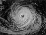
.jpg) Hurricane Fico never made landfall, though a strong east-northeasterly swell from the hurricane along with a strong southerly swell from a southern hemisphere storm produced high surf along the coastline of Hawaii
Hurricane Fico never made landfall, though a strong east-northeasterly swell from the hurricane along with a strong southerly swell from a southern hemisphere storm produced high surf along the coastline of Hawaii
. Civil Defense officials reported 30-foot (9.1 m) waves well offshore. The island of Hawaii
received breaking waves of 20 feet (6 m) in height, and eastern Maui
reported up to 12 feet (3.7 m) waves. Southern Oahu
and Kauai
also reported slightly above normal waves. Several ships in and around the periphery of the hurricane received moderate winds and rough surf, one of which reported swell waves of 41 feet (12.5 m). The high seas washed a 65-foot (20 m) tugboat ashore on a reef at Kukuiula. Six people aboard a sloop
off Hanalei
were rescued by a Navy torpedo boat after it lost its auxiliary power and was unable to progress in the strong winds of Fico. A strong trade wind
gradient, increased due to the presence of the hurricane, produced winds of over 60 mph (95 km/h) throughout the island chain. Hurricane Fico also dropped 6 inches (150 mm) of rainfall in Oahu.
Days before the hurricane passed to the south of the state, high surf from Fico caused some beach flooding in the eastern portion of the island of Hawaii. High surf later resulted in considerable damage to roads and beachfront houses along the Big Island shores. The waves destroyed a home in Puna
and wrecked a beach pavilion in Kau
. The mayors of three Hawaiian cities issued a disaster declaration for their cities following the damage from Fico. In Maui, moderate waves led to road flooding near the water, though no damage occurred on the island. 60 mph (95 km/h) winds throughout Hawaii downed trees, resulting in some power outages. Damage from the hurricane totaled $200,000 (1978 USD, $619,000 2006 USD).
for 20 days and 468 hours, breaking the previous record since the beginning of reliable satellite monitoring set by Hurricane Celeste
of 1972 with 16 days. Fico was also a hurricane for 17 days, which also broke the record set by Celeste of 1972 with 10 days. Both records were later broken by Hurricane Tina and then Hurricane John
. Fico also tracked about 6000 miles (9,656 km), among the longest tracks on record for a Pacific hurricane.
This hurricane was the only usage of the name Fico. The name Fico was removed after this storm and replaced with Fabio in the 1982 season
. It is unknown whether it was retired due to its damage or for another reason. Other possible reasons listed for the removal of a name are pronunciation ambiguity, a socially unacceptable meaning in another language, or because the storm name represented a significant human disaster.
Tropical cyclone
A tropical cyclone is a storm system characterized by a large low-pressure center and numerous thunderstorms that produce strong winds and heavy rain. Tropical cyclones strengthen when water evaporated from the ocean is released as the saturated air rises, resulting in condensation of water vapor...
of the 1978 Pacific hurricane season
1978 Pacific hurricane season
The 1978 Pacific hurricane season officially began May 15, 1978, in the eastern Pacific, June 1, 1978 in the central Pacific, and officially ended 30 November 1978. These dates conventionally delimit the period of time when tropical cyclones form in the eastern north Pacific Ocean.Activity this...
and at the time was the longest-lasting Pacific hurricane
Pacific hurricane
A Pacific hurricane or tropical storm is a tropical cyclone that develops in the northeastern part of the Pacific Ocean. For organizational purposes, the northern Pacific Ocean is divided into three regions: the eastern, , central , and western...
on record, the record being held today by Hurricane John
Hurricane John (1994)
Hurricane John formed during the 1994 Pacific hurricane season and became both the longest-lasting and the farthest-traveling tropical cyclone ever observed...
of 1994. The sixth tropical storm, fourth hurricane, and third major hurricane, Fico developed from a tropical disturbance off the coast of Mexico
Mexico
The United Mexican States , commonly known as Mexico , is a federal constitutional republic in North America. It is bordered on the north by the United States; on the south and west by the Pacific Ocean; on the southeast by Guatemala, Belize, and the Caribbean Sea; and on the east by the Gulf of...
on July 9. It moved northwestward and then westward, quickly reaching peak winds of 140 mph (220 km/h) on July 12. Moving nearly due westward, the intensity of Fico fluctuated from Category 1 to Category 4 status on the Saffir-Simpson Hurricane Scale
Saffir-Simpson Hurricane Scale
The Saffir–Simpson Hurricane Scale , or the Saffir–Simpson Hurricane Wind Scale , classifies hurricanes — Western Hemisphere tropical cyclones that exceed the intensities of tropical depressions and tropical storms — into five categories distinguished by the intensities of their sustained winds...
for the following days, and it passed about 170 miles (275 km) south of Hawaii
Hawaii
Hawaii is the newest of the 50 U.S. states , and is the only U.S. state made up entirely of islands. It is the northernmost island group in Polynesia, occupying most of an archipelago in the central Pacific Ocean, southwest of the continental United States, southeast of Japan, and northeast of...
on July 20 with winds of 115 mph (185 km/h). Fico slowly weakened as it turned to the northwest over cooler waters, and became an extratropical cyclone
Extratropical cyclone
Extratropical cyclones, sometimes called mid-latitude cyclones or wave cyclones, are a group of cyclones defined as synoptic scale low pressure weather systems that occur in the middle latitudes of the Earth having neither tropical nor polar characteristics, and are connected with fronts and...
on July 28 to the northeast of Midway Island
Midway Atoll
Midway Atoll is a atoll in the North Pacific Ocean, near the northwestern end of the Hawaiian archipelago, about one-third of the way between Honolulu, Hawaii, and Tokyo, Japan. Unique among the Hawaiian islands, Midway observes UTC-11 , eleven hours behind Coordinated Universal Time and one hour...
.
Swells from Fico, combined with swells from a storm in the Southern Hemisphere, produced rough surf throughout the Hawaiian islands. The surf destroyed one house and resulted in considerable damage along the southern coast of the island of Hawaii
Hawaii (island)
The Island of Hawaii, also called the Big Island or Hawaii Island , is a volcanic island in the North Pacific Ocean...
. No deaths were reported, and damage totaled $200,000 (1978 USD, $619,000 2006 USD).
Meteorological history
A tropical disturbance persisted 520 miles (835 km) south of AcapulcoAcapulco
Acapulco is a city, municipality and major sea port in the state of Guerrero on the Pacific coast of Mexico, southwest from Mexico City. Acapulco is located on a deep, semi-circular bay and has been a port since the early colonial period of Mexico’s history...
on July 3. It moved steadily westward and organized over warm water temperatures of 81° F (27° C). A circulation developed within the system, and on July 9 it organized into Tropical Depression Seven while located about 580 miles (930 km) southwest of Acapulco. The depression turned to the west-northwest, and after briefly weakening it organized more to attain tropical storm status on July 10 while located about 745 miles (1,200 km) south of the southern tip of Peninsula
Baja California Peninsula
The Baja California peninsula , is a peninsula in northwestern Mexico. Its land mass separates the Pacific Ocean from the Gulf of California. The Peninsula extends from Mexicali, Baja California in the north to Cabo San Lucas, Baja California Sur in the south.The total area of the Baja California...
.
Tropical Storm Fico turned to the northwest after reaching tropical storm status, and entered an area of increasingly warm water temperatures. It quickly strengthened, and 18 hours after becoming a tropical storm Fico strengthened into a hurricane. As the hurricane turned to the west-northwest, a well-defined eye
Eye (cyclone)
The eye is a region of mostly calm weather found at the center of strong tropical cyclones. The eye of a storm is a roughly circular area and typically 30–65 km in diameter. It is surrounded by the eyewall, a ring of towering thunderstorms where the second most severe weather of a cyclone...
developed in the center of the hurricane, and Fico continued to quickly intensify. Fico attained Category 4 strength about 24 hours after it first became a hurricane, and on July 12 it reached peak winds of 140 mph (220 km/h) while located 640 miles (1,030 km) southwest of Cabo San Lucas
Cabo San Lucas
Cabo San Lucas , commonly called Cabo, is a city at the southern tip of the Baja California peninsula, in the municipality of Los Cabos in the Mexican state of Baja California Sur. As of the 2010 census, the population was 68,463 people...
. Throughout its duration, the eye of the hurricane was around 35 miles (56.3 km) in diameter.
While moving nearly due westward, Fico maintained peak winds for about 12 hours before weakening over cooler water temperatures. On July 14, passing over an area of 79 °F (26 °C) waters, the hurricane became disorganized while its winds dropped to 90 mph (150 km/h). Shortly thereafter, it again moved into an area of 83 °F (28 °C) waters, and again reached winds of 135 mph (215 km/h) on July 15. For 48 hours, Fico's winds fluctuated slightly, briefly dropping to 120 mph (195 km/h) before strengthening again to 135 mph (215 km/h). On July 17 the hurricane again began to weaken, and its winds dropped to 90 mi/h as Fico entered the Central Pacific Hurricane Center
Central Pacific Hurricane Center
The Central Pacific Hurricane Center of the United States National Weather Service is the official body responsible for tracking and issuing tropical cyclone warnings, watches, advisories, discussions, and statements for the Central North Pacific Basin...
area of responsibility. Fico slowly retrengthened and reached Category 3 status late on July 20 while passing about 170 miles (275 km) south of the island of Hawaii
Hawaii (island)
The Island of Hawaii, also called the Big Island or Hawaii Island , is a volcanic island in the North Pacific Ocean...
. The hurricane turned to the northwest toward an upper-level trough
Trough (meteorology)
A trough is an elongated region of relatively low atmospheric pressure, often associated with fronts.Unlike fronts, there is not a universal symbol for a trough on a weather chart. The weather charts in some countries or regions mark troughs by a line. In the United States, a trough may be marked...
of low pressure, and after maintaining 115 mph (185 km/h) winds for about 36 hours it slowly weakened. On July 27 after entering an area of progressively cooler waters, Fico weakened to a tropical storm while located about 35 miles (60 km) east-northeast of Midway Island
Midway Atoll
Midway Atoll is a atoll in the North Pacific Ocean, near the northwestern end of the Hawaiian archipelago, about one-third of the way between Honolulu, Hawaii, and Tokyo, Japan. Unique among the Hawaiian islands, Midway observes UTC-11 , eleven hours behind Coordinated Universal Time and one hour...
. It weakened to a tropical depression the next day, and late on July 28 after turning to the north Fico became an extratropical depression
Extratropical cyclone
Extratropical cyclones, sometimes called mid-latitude cyclones or wave cyclones, are a group of cyclones defined as synoptic scale low pressure weather systems that occur in the middle latitudes of the Earth having neither tropical nor polar characteristics, and are connected with fronts and...
. An approaching cold front
Surface weather analysis
Surface weather analysis is a special type of weather map that provides a view of weather elements over a geographical area at a specified time based on information from ground-based weather stations...
absorbed the remnants of Fico and passed near southern Alaska
Alaska
Alaska is the largest state in the United States by area. It is situated in the northwest extremity of the North American continent, with Canada to the east, the Arctic Ocean to the north, and the Pacific Ocean to the west and south, with Russia further west across the Bering Strait...
on July 31. Ships to the southeast of Cold Bay
Cold Bay, Alaska
Cold Bay is a city in Aleutians East Borough, Alaska, United States.Cold Bay is one of the main commercial centers of the Alaska Peninsula, and is home to Cold Bay Airport.-History:...
reported heavy rainfall and strong winds in association with the remnants of Fico.
Impact
Hawaii
Hawaii is the newest of the 50 U.S. states , and is the only U.S. state made up entirely of islands. It is the northernmost island group in Polynesia, occupying most of an archipelago in the central Pacific Ocean, southwest of the continental United States, southeast of Japan, and northeast of...
. Civil Defense officials reported 30-foot (9.1 m) waves well offshore. The island of Hawaii
Hawaii (island)
The Island of Hawaii, also called the Big Island or Hawaii Island , is a volcanic island in the North Pacific Ocean...
received breaking waves of 20 feet (6 m) in height, and eastern Maui
Maui
The island of Maui is the second-largest of the Hawaiian Islands at and is the 17th largest island in the United States. Maui is part of the state of Hawaii and is the largest of Maui County's four islands, bigger than Lānai, Kahoolawe, and Molokai. In 2010, Maui had a population of 144,444,...
reported up to 12 feet (3.7 m) waves. Southern Oahu
Oahu
Oahu or Oahu , known as "The Gathering Place", is the third largest of the Hawaiian Islands and most populous of the islands in the U.S. state of Hawaii. The state capital Honolulu is located on the southeast coast...
and Kauai
Kauai
Kauai or Kauai, known as Tauai in the ancient Kaua'i dialect, is geologically the oldest of the main Hawaiian Islands. With an area of , it is the fourth largest of the main islands in the Hawaiian archipelago, and the 21st largest island in the United States. Known also as the "Garden Isle",...
also reported slightly above normal waves. Several ships in and around the periphery of the hurricane received moderate winds and rough surf, one of which reported swell waves of 41 feet (12.5 m). The high seas washed a 65-foot (20 m) tugboat ashore on a reef at Kukuiula. Six people aboard a sloop
Sloop
A sloop is a sail boat with a fore-and-aft rig and a single mast farther forward than the mast of a cutter....
off Hanalei
Hanalei, Hawaii
Hanalei is a census-designated place in Kauai County, Hawaii, United States. The population was 478 at the 2000 census. Hanalei means "lei making" in Hawaiian...
were rescued by a Navy torpedo boat after it lost its auxiliary power and was unable to progress in the strong winds of Fico. A strong trade wind
Trade wind
The trade winds are the prevailing pattern of easterly surface winds found in the tropics, within the lower portion of the Earth's atmosphere, in the lower section of the troposphere near the Earth's equator...
gradient, increased due to the presence of the hurricane, produced winds of over 60 mph (95 km/h) throughout the island chain. Hurricane Fico also dropped 6 inches (150 mm) of rainfall in Oahu.
Days before the hurricane passed to the south of the state, high surf from Fico caused some beach flooding in the eastern portion of the island of Hawaii. High surf later resulted in considerable damage to roads and beachfront houses along the Big Island shores. The waves destroyed a home in Puna
Puna, Hawaii
Puna is one of the nine districts in Hawaii County, Big Island, Hawaii. The District of Puna is located on the easternmost portion of the island and shares borders to the north with the District of South Hilo and a border to the west with the District of Kaū...
and wrecked a beach pavilion in Kau
Kau, Hawaii
thumb|right|300px|The districts of the [[Hawaii |Big Island]]. From Northernmost, clockwise; [[Kohala, Hawaii|Kohala]], [[Hamakua]], [[Hilo, Hawaii|Hilo]], [[Puna, Hawaii|Puna]], Kau , [[Kona District, Hawaii|Kona]]...
. The mayors of three Hawaiian cities issued a disaster declaration for their cities following the damage from Fico. In Maui, moderate waves led to road flooding near the water, though no damage occurred on the island. 60 mph (95 km/h) winds throughout Hawaii downed trees, resulting in some power outages. Damage from the hurricane totaled $200,000 (1978 USD, $619,000 2006 USD).
Records and Naming
Fico was a Pacific tropical cyclonePacific hurricane
A Pacific hurricane or tropical storm is a tropical cyclone that develops in the northeastern part of the Pacific Ocean. For organizational purposes, the northern Pacific Ocean is divided into three regions: the eastern, , central , and western...
for 20 days and 468 hours, breaking the previous record since the beginning of reliable satellite monitoring set by Hurricane Celeste
1972 Pacific hurricane season
The 1972 Pacific hurricane season was an ongoing event in tropical cyclone meteorology. There were few notable storms this year. No one was killed and storm effects were generally not serious. The most notable systems were Hurricane Celeste and Joanne. Celeste was the strongest storm of the...
of 1972 with 16 days. Fico was also a hurricane for 17 days, which also broke the record set by Celeste of 1972 with 10 days. Both records were later broken by Hurricane Tina and then Hurricane John
Hurricane John (1994)
Hurricane John formed during the 1994 Pacific hurricane season and became both the longest-lasting and the farthest-traveling tropical cyclone ever observed...
. Fico also tracked about 6000 miles (9,656 km), among the longest tracks on record for a Pacific hurricane.
This hurricane was the only usage of the name Fico. The name Fico was removed after this storm and replaced with Fabio in the 1982 season
1982 Pacific hurricane season
The 1982 Pacific hurricane season officially started May 15, 1982 in the eastern Pacific, and June 1, 1982 in the central Pacific, and lasted until November 30, 1982. These dates conventionally delimit the period of each year when most tropical cyclones form in the northeastern Pacific Ocean.The...
. It is unknown whether it was retired due to its damage or for another reason. Other possible reasons listed for the removal of a name are pronunciation ambiguity, a socially unacceptable meaning in another language, or because the storm name represented a significant human disaster.
See also
- List of Pacific hurricanes
- List of retired Pacific hurricane names
- List of Hawaii hurricanes