
1982 Pacific hurricane season
Encyclopedia
The 1982 Pacific hurricane season officially started May 15, 1982 in the eastern Pacific, and June 1, 1982 in the central Pacific, and lasted until November 30, 1982. These dates conventionally delimit the period of each year when most tropical cyclones form in the northeastern Pacific Ocean
.
The 1982 season was an eventful one. Hurricane Paul killed over 1,000 people before it was named. Hurricanes Daniel and Gilma both briefly threatened Hawaii, while Hurricane Iwa caused heavy damage to Kauai
and Niihau
. The remnants of Hurricane Olivia brought heavy rain to a wide swath of the western United States.
and Nicaragua
, causing flooding. Throughout the two countries, 308 people were killed and total damage was at $457 million (1982 USD). In the aftermath of the storm, many programs provided relief to the victims of Aletta.
on the morning of May 27. The next day it moved southwest into Guatemala
with significant thunderstorm activity, emerging into the Gulf of Tehuantepec
around noon on May 29. By May 31, it was organized enough to be considered a tropical depression. Slowly weakening on June 1 as it remained quasi-stationary, the system dissipated in the Gulf of Tehuantepec on June 4.
by the morning of June 19.
and the Big Island of Hawaii.
into cooler waters, eventually dissipating late on July 24.
. Strengthening continued, as Hector became a tropical storm on the morning of July 29 and a hurricane by noon on July 30. A combination of vertical wind shear and cooler waters ahead of the cyclone led to its weakening trend, which hastened on August 1. It weakened to a tropical storm on the morning of August 2 and to a depression soon thereafter while located midway between the Hawaiian Islands and southern Baja California.
, and dissipated late on August 10 to the southwest of Hawaii.
on August 4 and slowly consolidated. By the afternoon of August 8, Tropical Depression Eighteen-E developed well south of Cabo San Lucas
. The next morning it had continued strengthening into a tropical storm. Maximum sustained winds reached 60 mph (97 km/h) as it continued moving west-northwest. Vertical wind shear reached Lane on August 10, which led to weakening. It weakened to a tropical depression late on August 11, but sporadic thunderstorm blowups near the center kept the system alive for another few days. Dissipation occurred on the evening of August 14 as it crossed the 140th meridian west
.
for "Anthony". Maximum sustained winds increased to 60 mph (97 km/h) late on August 31 as Akoni moved near the ship Nana Lolo a few hundred miles east of the International Dateline. An upper trough to the northwest set Akoni on a weakening curve, and the cyclone diminished to a tropical depression on the evening of September 1 as it moved with the low level flow. The weakening depression passed the International Dateline into the western Pacific on the morning of September 2.
and Arizona
.
back into the eastern Pacific near the 20th parallel north
, the depression dissipated.
and the surface low was last seen dissipating on September 25 about 250 mi (400 km) west-southwest of San Diego.
The heavy rain in California wiped out half of the raisin crop, a quarter of the wine crop, and a tenth of the tomato crop. Olivia's remnants brought rain totals of over seven in (177 mm) to California and northern Utah
as they interacted with a strong upper level system and the local topography. The precipitation from this storm largely contributed to the record monthly precipitation in Salt Lake City, Utah of 7.04 in (179 mm). These rains resulted in widespread losses, mainly from agriculture, amounting to $325 million (1982 USD).
and El Salvador
. It moved westward, reached 110 mph (180 km/h) Category 2 hurricane strength, and made landfall on northwest Mexico
in late September.
Despite the fact that it was only numbered when it killed over 1,000 people, Paul is still the second-deadliest East Pacific tropical cyclone. Only the unnamed 1959 Mexico Hurricane
killed more people.
on October 12. Moving west-northwest, the system organized into a tropical depression as it crossed the 91st meridian west
late on October 13 and became a tropical storm by October 14 as it entered the Gulf of Tehuantepec. It strengthened into a hurricane late that day as it passed 95°W
. By the afternoon of October 17, Sergio was packing sustained winds of 120 mph (190 km/h). Cooler water was reached soon afterwards, and weakening commenced. While slowly moving west, Sergio weakened to a tropical storm by the afternoon of October 21 and to a tropical depression late on October 22. The system dissipated near 19°N 133°W on the afternoon of October 23.
for "thief", and refers to a kind of frigatebird
that steals fish from other birds. The storm accelerated northeast after reaching hurricane intensity November 23.
Iwa's eye passed with 25 mi (40 km) of Kauai
and even closer to Niihau
. Both islands were caught in the storm's dangerous semicircle. Iwa continued northeast and became extratropical November 25.
Damage was extensive and amounted to a quarter billion dollars, which was the costliest tropical cyclone for Hawaii until Hurricane Iniki
struck in 1992. Most of the damage was from the winds. Despite the damage, there was only one death on the islands.
. This is the same list used in the 1978 season
, except for Fabio, which replaced Fico
. A storm was named Fabio for the first time in 1982. Names that were not assigned are marked in gray.
Four names from the Central Pacific list were used - Akoni, Ema, Hana, and Iwa
. This was the first usage for all of these names. With four names being used, this season holds the record for most named storms forming in the central Pacific.
and 140°W
were given names from the Hawaiian language
. Previous to this year, names and numbers from the western Pacific's typhoon list were used.
After this year that it was decided to use six-year lists in the eastern Pacific, instead of four-year ones. This is the reason that this season's list is the same as the 1978 season
's list.
Pacific Ocean
The Pacific Ocean is the largest of the Earth's oceanic divisions. It extends from the Arctic in the north to the Southern Ocean in the south, bounded by Asia and Australia in the west, and the Americas in the east.At 165.2 million square kilometres in area, this largest division of the World...
.
The 1982 season was an eventful one. Hurricane Paul killed over 1,000 people before it was named. Hurricanes Daniel and Gilma both briefly threatened Hawaii, while Hurricane Iwa caused heavy damage to Kauai
Kauai
Kauai or Kauai, known as Tauai in the ancient Kaua'i dialect, is geologically the oldest of the main Hawaiian Islands. With an area of , it is the fourth largest of the main islands in the Hawaiian archipelago, and the 21st largest island in the United States. Known also as the "Garden Isle",...
and Niihau
Niihau
Niihau or Niihau is the seventh largest of the inhabited Hawaiian Islands in the U.S. state of Hawaii, having an area of . Niihau lies southwest of Kauai across the Kaulakahi Channel. Several intermittent playa lakes provide wetland habitats for the Hawaiian Coot, the Black-winged Stilt, and the...
. The remnants of Hurricane Olivia brought heavy rain to a wide swath of the western United States.
Storms
This season had nineteen tropical storms, eleven hurricanes, and five major hurricanes. Three tropical storms and one hurricane— a record number of named storms— formed in the central Pacific. This was largely due to a strong El Niño present during the season.Tropical Storm Aletta
An area of disturbed weather developed into a tropical depression on May 20, and a tropical storm around noon on May 21. The cyclone turned northeast, reaching its as a strong tropical storm on May 23. Aletta meandered and gradually weakened. Tropical Depression Aletta dissipated on May 29 a modest distance southwest of Acapulco. Moisture from the tropical system spread over HondurasHonduras
Honduras is a republic in Central America. It was previously known as Spanish Honduras to differentiate it from British Honduras, which became the modern-day state of Belize...
and Nicaragua
Nicaragua
Nicaragua is the largest country in the Central American American isthmus, bordered by Honduras to the north and Costa Rica to the south. The country is situated between 11 and 14 degrees north of the Equator in the Northern Hemisphere, which places it entirely within the tropics. The Pacific Ocean...
, causing flooding. Throughout the two countries, 308 people were killed and total damage was at $457 million (1982 USD). In the aftermath of the storm, many programs provided relief to the victims of Aletta.
Tropical Depression Two-E
This system originated as a low in the western Caribbean SeaCaribbean Sea
The Caribbean Sea is a sea of the Atlantic Ocean located in the tropics of the Western hemisphere. It is bounded by Mexico and Central America to the west and southwest, to the north by the Greater Antilles, and to the east by the Lesser Antilles....
on the morning of May 27. The next day it moved southwest into Guatemala
Guatemala
Guatemala is a country in Central America bordered by Mexico to the north and west, the Pacific Ocean to the southwest, Belize to the northeast, the Caribbean to the east, and Honduras and El Salvador to the southeast...
with significant thunderstorm activity, emerging into the Gulf of Tehuantepec
Gulf of Tehuantepec
Gulf of Tehuantepec is a large body of water on the Pacific coast of the Isthmus of Tehuantepec, southeastern Mexico, at . Most of the hurricanes that form in the Eastern Pacific organize in or near this body of water...
around noon on May 29. By May 31, it was organized enough to be considered a tropical depression. Slowly weakening on June 1 as it remained quasi-stationary, the system dissipated in the Gulf of Tehuantepec on June 4.
Tropical Depression Three-E
This cyclone formed well to the west-southwest of Mexico on June 12. The depression slowly recurved due to an upper level low located well to its north-northwest. By June 15, vertical wind shear had taken its toll and the system dissipated about 300 mi (500 km) north of where it formed.Tropical Storm Bud
On June 15, this cyclone formed about 460 mi (740 km) southwest of Acapulco. Drifting west-northwest, it quickly strengthened into a tropical storm. Maximum sustained winds peaked near 50 mph (80 km/h) late on June 15. Turning south of due west, vertical wind shear weakened Bud, with the cyclone dissipating by the morning of June 17 about 23 mi (370 km) north-northwest of Clipperton Island.Tropical Depression Five-E
Late on June 16, deep convection organized in the Gulf of Tehuantepec into a tropical depression. Transcribing a small clockwise loop, the system moved west-northwest. Interaction with Mexico likely played a role in its weakening as water temperatures under the system were never below 82°F (28°C). The system dissipated about 90 mi (150 km) south of Puerto ÁngelPuerto Ángel
Puerto Ángel is a small coastal town in the Mexican state of Oaxaca located in the municipality of San Pedro Pochutla. It, along with San Agustinillo and Playa Zipolite are known as the "Riviera Oaxaqueña. It is located 9 km south of city of Pochutla fifty km west of Huatulco and eighty km...
by the morning of June 19.
Tropical Storm Carlotta
A tropical wave crossed Central America on June 26, creating an area of thunderstorms just inside the tropical eastern Pacific that morning. Cyclonic turning was evident by the night of June 30 while located roughly 350 mi (550 km) south of Manzanillo as the system continued westward. Slowly turning northwest, the system was upgraded to a tropical depression early on July 1 and a tropical storm by nightfall. Maximum sustained winds increased to 60 mph (97 km/h) by noon July 3. Increasingly southwest flow aloft turned Carlotta more northward into cooler waters, causing the cyclone to regain tropical depression status on the evening of July 4, ultimately dissipating southwest of Cabo San Lucas the next evening.Tropical Depression Seven-E
The system formed between Tropical Storm Carlotta and the Hawaiian Islands on the evening of July 2. Slowly recurving north and northeast, the system moved into cooler waters and dissipated about 100 mi (160 km) north of where it formed by the afternoon of July 3.Hurricane Daniel
Tropical Depression Eight-E formed south of Mexico on July 7. Moving west-northwest, the cyclone slowly strengthened into a tropical storm around noon on July 8 before becoming a hurricane late in the afternoon of July 9. Daniel reached its maximum intensity of 115 mph (185 km/h) early in the morning of July 11 a few hundred miles southwest of Manzanillo, Mexico. As the storm moved westward, it slowly weakened. Daniel regained tropical storm status during the night of July 14, entering the Central Pacific Basin as a weakening tropical storm on the morning of July 16. Daniel retained tropical storm intensity for the next few days before weakening into a tropical depression about 280 mi (450 km) south southwest of the Big Island of Hawaii, being sheared by the same upper trough that caused Emilia's dissipation a few days earlier. Daniel turned northward, and on July 22, dissipated in the Alenuihaha Channel between MauiMaui
The island of Maui is the second-largest of the Hawaiian Islands at and is the 17th largest island in the United States. Maui is part of the state of Hawaii and is the largest of Maui County's four islands, bigger than Lānai, Kahoolawe, and Molokai. In 2010, Maui had a population of 144,444,...
and the Big Island of Hawaii.
Tropical Storm Emilia
Tropical Depression Nine-E developed near 10.0° N 136.5° W on the morning of July 12. Intensifying, the cyclone became a tropical storm later that day. Emilia moved westward around 13 mph (21 km/h) and entered the Central Pacific Basin on the night of July 12. Over the next day, the storm moved west-northwest, reaching maximum sustained winds of 65 mph (105 km/h). An upper trough to the west weakened Emilia rapidly due to vertical wind shear, and the cyclone weakened to tropical depression status early on the morning of July 15. Dissipation of the tropical depression was noted by afternoon.Tropical Depression Ten-E
To the east of Daniel, a tropical depression formed on the evening of July 13 a few hundred miles west-southwest of Manzanillo. The system moved westward and weakened thereafter, dissipating about 200 mi (320 km) west of where it had formed by the afternoon of July 14.Tropical Depression Eleven-E
A tropical disturbance was spotted about 650 mi (930 km) southwest of Acapulco on July 12. By the evening of July 15, cyclonic turning was evident and the system was upgraded to a tropical depression. Moving unsteadily to the west-northwest, the system weakened, dissipating a few hundred miles west-northwest of where it had formed.Hurricane Fabio
The cyclone developed as a tropical depression southeast of Manzanillo on July 17. Over the next couple of days, it strengthened rapidly into a hurricane as it moved northwest, peaking in intensity with 75 mph (121 km/h) winds. Gradual weakening occurred as Fabio turned westward along the 19th parallel north19th parallel north
The 19th parallel north is a circle of latitude that is 19 degrees north of the Earth's equatorial plane. It crosses Africa, Asia, the Indian Ocean, the Pacific Ocean, North America, the Caribbean and the Atlantic Ocean....
into cooler waters, eventually dissipating late on July 24.
Hurricane Gilma
Tropical Depression Thirteen-E formed near 9.5°N 117°30'W and moved slightly north of west. Tropical storm status was attained near noon on July 26, and the cyclone crossed the threshold of hurricane strength late on the night of July 27. By noon on July 29, Gilma reached it maximum intensity of 125 mph (200 km/h) well to the east-southeast of Hawaii. The cyclone weakened and sped up its motion to the west-northwest, crossing into the Central Pacific Basin as a category one hurricane very early on July 30. Gilma was downgraded to a tropical storm late in the morning of July 30, and a tropical depression early on the morning of August 1 as the circulation passed 50 mi (80 km) south of South Point. The cyclone dissipated late on August 1 as it passed 200 mi (300 km) south of Kauai.Hurricane Hector
On July 23, a tropical wave moved off the Colombian coast. The related convection moved westward at over 20 mph (32 km/h). By the evening of July 27, the system slowed its forward motion. The next evening, a tropical depression organized within the thunderstorm activity well to the south of Baja CaliforniaBaja California
Baja California officially Estado Libre y Soberano de Baja California is one of the 31 states which, with the Federal District, comprise the 32 Federal Entities of Mexico. It is both the northernmost and westernmost state of Mexico. Before becoming a state in 1953, the area was known as the North...
. Strengthening continued, as Hector became a tropical storm on the morning of July 29 and a hurricane by noon on July 30. A combination of vertical wind shear and cooler waters ahead of the cyclone led to its weakening trend, which hastened on August 1. It weakened to a tropical storm on the morning of August 2 and to a depression soon thereafter while located midway between the Hawaiian Islands and southern Baja California.
Tropical Storm Iva
A tropical disturbance was discovered 300 mi (460 km) south of Acapulco on July 31. Moving west-northwest, it achieved tropical depression status that night and tropical storm status on August 2 while 800 mi (1,340 km) west-southwest of Acapulco. Northeasterly upper level shear appears to have been Iva's nemesis, as the system weakened back into a tropical depression by the afternoon of August 3 as it turned west-southwest. The depression maintained strength for another several days before dissipating well east-southwest of Hilo, Hawaii on the morning of August 8.Hurricane John
Tropical Depression Sixteen-E formed on August 3 in the East Pacific between Hawaii and Mexico. The system intensified into a tropical storm by noon August 4, and a hurricane on the morning of August 5. John reached its peak intensity of 115 mph (185 km/h) as it moved into the Central Pacific Basin on August 6. Weakening commenced on August 7 due to westerly vertical wind shear caused by the semi-permanent mid-oceanic upper trough, and John weakened to a tropical storm on the night of August 8. It passed by as a tropical depression about 180 mi (290 km) south of the Island of HawaiiHawaii (island)
The Island of Hawaii, also called the Big Island or Hawaii Island , is a volcanic island in the North Pacific Ocean...
, and dissipated late on August 10 to the southwest of Hawaii.
Hurricane Kristy
Tropical Depression Seventeen-E formed by noon on August 8 in the East Pacific. The low moved west, intensified, and became Tropical Storm Kristy by midnight, and a hurricane by midnight on the night of August 9. Weakening as it entered the Central Pacific, Kristy regained tropical storm status late on August 10 while moving south of due west at a rapid 30 mph (48 km/h). As it slowed down and turned northwest, Kristy began to restrengthen. Hurricane intensity was reached again on the evening of August 13. By noon on August 14, the cyclone passed 250 mi (400 km) south of South Point, Hawaii. Westerly winds aloft slowed Kristy's forward motion down additionally, and Kristy weakened back into a tropical storm on August 15. Turning more to the west with the low level wind flow, the cyclone was downgraded to a tropical depression by noon on August 16 and dissipated that night southwest of Hawaii.Tropical Storm Lane
The originating disturbance of this system emerged off San José, Costa RicaSan José, Costa Rica
San José is the capital and largest city of Costa Rica. Located in the Central Valley, San José is the seat of national government, the focal point of political and economic activity, and the major transportation hub of this Central American nation.Founded in 1738 by order of Cabildo de León, San...
on August 4 and slowly consolidated. By the afternoon of August 8, Tropical Depression Eighteen-E developed well south of Cabo San Lucas
Cabo San Lucas
Cabo San Lucas , commonly called Cabo, is a city at the southern tip of the Baja California peninsula, in the municipality of Los Cabos in the Mexican state of Baja California Sur. As of the 2010 census, the population was 68,463 people...
. The next morning it had continued strengthening into a tropical storm. Maximum sustained winds reached 60 mph (97 km/h) as it continued moving west-northwest. Vertical wind shear reached Lane on August 10, which led to weakening. It weakened to a tropical depression late on August 11, but sporadic thunderstorm blowups near the center kept the system alive for another few days. Dissipation occurred on the evening of August 14 as it crossed the 140th meridian west
140th meridian west
The meridian 140° west of Greenwich is a line of longitude that extends from the North Pole across the Arctic Ocean, North America, the Pacific Ocean, the Southern Ocean, and Antarctica to the South Pole....
.
Hurricane Miriam
Tropical Depression Nineteen-E formed on August 29 a couple hundred miles southwest of Manzanillo, Mexico. The depression moved west-northwestward, intensifying into a tropical storm by noon on August 30 and a hurricane by noon on August 31. Peak intensity of 90 mph (145 km/h) was attained during the early morning of September 1. For the next couple of days, Miriam remained unchanged in strength. By late on September 3, a weakening trend was realized as it passed into the Central Pacific by the afternoon of September 4. Shearing apart soon afterwards, the low moved northwest and weakened into a tropical depression well to the east of Hawaii on the morning of September 5. It drifted north, and became a nontropical low by September 6. The cyclone was last noted near 30°N 149°W, continuing its northward trek.Tropical Storm Akoni
Tropical Depression One-C formed along the eastern end of the West Pacific monsoon trough on August 30 about 700 mi (1120 km) east of the International Dateline, well to the west-southwest of Hawaii. Moving slowly westward, the system intensified rapidly into a tropical storm by noon and was named Akoni. The name "Akoni" is short for Anakoni, which is HawaiianHawaiian language
The Hawaiian language is a Polynesian language that takes its name from Hawaii, the largest island in the tropical North Pacific archipelago where it developed. Hawaiian, along with English, is an official language of the state of Hawaii...
for "Anthony". Maximum sustained winds increased to 60 mph (97 km/h) late on August 31 as Akoni moved near the ship Nana Lolo a few hundred miles east of the International Dateline. An upper trough to the northwest set Akoni on a weakening curve, and the cyclone diminished to a tropical depression on the evening of September 1 as it moved with the low level flow. The weakening depression passed the International Dateline into the western Pacific on the morning of September 2.
Hurricane Norman
Northeasterly shear slowed the development of the initial tropical depression which formed into Norman. Strengthening began in earnest on September 11, and the cyclone became a tropical storm, and then a hurricane by early on September 13. Maximum sustained winds reached nearly 95 mph (153 km/h) by September 15. A mid-latitude trough dug in from the north, weakening the ridge north of Norman and leading to a northward motion. Increased vertical wind shear and cooler waters weakened the hurricane, with dissipation occurring just west of Baja California on September 18. On September 17 and 18, moisture from Norman brought scattered rain to CaliforniaCalifornia
California is a state located on the West Coast of the United States. It is by far the most populous U.S. state, and the third-largest by land area...
and Arizona
Arizona
Arizona ; is a state located in the southwestern region of the United States. It is also part of the western United States and the mountain west. The capital and largest city is Phoenix...
.
Tropical Depression Twenty-One-E
A tropical depression formed well east-southeast of Hawaii late on September 10. Moving over cooler waters soon after formation, the depression dissipated by the next evening near 14°N 134°W.Tropical Storm Ema
An area of convection formed near 15°N 140°W and by 15 September, a tropical depression had formed within the thunderstorm activity. Strengthening as it moved slowly north-northeast, the cyclone became a tropical storm late that day. Ema became stationary between the morning of September 16 and September 17 before resuming its north-northeast heading. Its peak intensity was 45 mph (72 km/h). Upper level shear weakened the system into a tropical depression by noon on September 18. As it crossed the 140th meridian west140th meridian west
The meridian 140° west of Greenwich is a line of longitude that extends from the North Pole across the Arctic Ocean, North America, the Pacific Ocean, the Southern Ocean, and Antarctica to the South Pole....
back into the eastern Pacific near the 20th parallel north
20th parallel north
The 20th parallel north is a circle of latitude that is 20 degrees north of the Earth's equatorial plane. It crosses Africa, Asia, the Indian Ocean, the Pacific Ocean, North America, the Caribbean and the Atlantic Ocean....
, the depression dissipated.
Tropical Storm Hana
An area of thunderstorms stewed south of the Hawaiian Islands for several days. By September 15, it had organized into Tropical Depression Three-C, and quickly became a tropical storm that afternoon. The cyclone moved north-northwest for a day before slowing to a crawl for the next day. The cyclone turned southwest and weakened into a tropical depression due to vertical wind shear. It dissipated southwest of Hawaii near 13°N 162°W late on September 18.Hurricane Olivia
Ship reports indicated that a tropical depression had formed about 400 mi (640 km) south-southwest of Acapulco around noon on September 18. The system drifted north-northwest, developing into a tropical storm that night. About 24 hours later, Olivia became a hurricane. Rapid intensification continued, and Olivia reached its peak intensity of 130 mph (210 km/h) winds around noon September 21, becoming the strongest storm of the season. The next day, waters under the tropical cyclone began to cool as the hurricane gained increasing latitude offshore Mexico. By noon on September 23, the cyclone had weakened into a tropical storm west of Baja California. Strong southwest flow to its north spread precipitation through the western United States into southwest Canada. The cyclone weakened to a tropical depression about 500 mi (800 km) southwest of San DiegoSan Diego, California
San Diego is the eighth-largest city in the United States and second-largest city in California. The city is located on the coast of the Pacific Ocean in Southern California, immediately adjacent to the Mexican border. The birthplace of California, San Diego is known for its mild year-round...
and the surface low was last seen dissipating on September 25 about 250 mi (400 km) west-southwest of San Diego.
The heavy rain in California wiped out half of the raisin crop, a quarter of the wine crop, and a tenth of the tomato crop. Olivia's remnants brought rain totals of over seven in (177 mm) to California and northern Utah
Utah
Utah is a state in the Western United States. It was the 45th state to join the Union, on January 4, 1896. Approximately 80% of Utah's 2,763,885 people live along the Wasatch Front, centering on Salt Lake City. This leaves vast expanses of the state nearly uninhabited, making the population the...
as they interacted with a strong upper level system and the local topography. The precipitation from this storm largely contributed to the record monthly precipitation in Salt Lake City, Utah of 7.04 in (179 mm). These rains resulted in widespread losses, mainly from agriculture, amounting to $325 million (1982 USD).
Hurricane Paul
Paul was the deadliest storm of the season. Only as a tropical depression, it killed over 1,000 people in GuatemalaGuatemala
Guatemala is a country in Central America bordered by Mexico to the north and west, the Pacific Ocean to the southwest, Belize to the northeast, the Caribbean to the east, and Honduras and El Salvador to the southeast...
and El Salvador
El Salvador
El Salvador or simply Salvador is the smallest and the most densely populated country in Central America. The country's capital city and largest city is San Salvador; Santa Ana and San Miguel are also important cultural and commercial centers in the country and in all of Central America...
. It moved westward, reached 110 mph (180 km/h) Category 2 hurricane strength, and made landfall on northwest Mexico
Mexico
The United Mexican States , commonly known as Mexico , is a federal constitutional republic in North America. It is bordered on the north by the United States; on the south and west by the Pacific Ocean; on the southeast by Guatemala, Belize, and the Caribbean Sea; and on the east by the Gulf of...
in late September.
Despite the fact that it was only numbered when it killed over 1,000 people, Paul is still the second-deadliest East Pacific tropical cyclone. Only the unnamed 1959 Mexico Hurricane
1959 Mexico Hurricane
The 1959 Mexico Hurricane was a devastating tropical cyclone that was one of the worst ever Pacific hurricanes. It impacted the Pacific coast of Mexico in October 1959. It killed at least 1,000 people, and perhaps double that, a record that still stands, and caused at least 280 million...
killed more people.
Tropical Storm Rosa
A well-organized tropical depression formed in the Gulf of Tehuantepec on September 30. Moving slowly northwest, the system became a tropical storm, reaching maximum sustained winds of 50 mph (80 km/h) on the afternoon of October 2. The system slowly weakened as it moved northwest, and Rosa brushed the Pacific coast of Mexico as a dissipating depression.Hurricane Sergio
A tropical disturbance was noted southwest of Costa RicaCosta Rica
Costa Rica , officially the Republic of Costa Rica is a multilingual, multiethnic and multicultural country in Central America, bordered by Nicaragua to the north, Panama to the southeast, the Pacific Ocean to the west and the Caribbean Sea to the east....
on October 12. Moving west-northwest, the system organized into a tropical depression as it crossed the 91st meridian west
91st meridian west
The meridian 91° west of Greenwich is a line of longitude that extends from the North Pole across the Arctic Ocean, North America, the Gulf of Mexico, Central America, the Pacific Ocean, the Southern Ocean, and Antarctica to the South Pole....
late on October 13 and became a tropical storm by October 14 as it entered the Gulf of Tehuantepec. It strengthened into a hurricane late that day as it passed 95°W
95th meridian west
The meridian 95° west of Greenwich is a line of longitude that extends from the North Pole across the Arctic Ocean, North America, the Gulf of Mexico, Central America, the Pacific Ocean, the Southern Ocean, and Antarctica to the South Pole....
. By the afternoon of October 17, Sergio was packing sustained winds of 120 mph (190 km/h). Cooler water was reached soon afterwards, and weakening commenced. While slowly moving west, Sergio weakened to a tropical storm by the afternoon of October 21 and to a tropical depression late on October 22. The system dissipated near 19°N 133°W on the afternoon of October 23.
Tropical Storm Tara
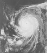
A tropical disturbance emerged off the coast of Central America. Cyclonic turning was noted on the afternoon of October 19, and a tropical depression formed 350 mi (560 km) south of Acapulco. Staggering west-northwestward, the cyclone became a tropical storm by the morning of the October 22. Maximum sustained winds increased to 50 mph (80 km/h) late on October 24. As it moved over cooler waters on October 25, the system weakened to a tropical depression that afternoon, dissipating that night near 21°N 130°W.Hurricane Iwa
Late in the season, a nearly stationary disturbance with a cyclonic circulation organized into a tropical storm and was named Iwa. Iwa is HawaiianHawaiian language
The Hawaiian language is a Polynesian language that takes its name from Hawaii, the largest island in the tropical North Pacific archipelago where it developed. Hawaiian, along with English, is an official language of the state of Hawaii...
for "thief", and refers to a kind of frigatebird
Frigatebird
The frigatebirds are a family, Fregatidae, of seabirds. There are five species in the single genus Fregata. They are also sometimes called Man of War birds or Pirate birds. Since they are related to the pelicans, the term "frigate pelican" is also a name applied to them...
that steals fish from other birds. The storm accelerated northeast after reaching hurricane intensity November 23.
Iwa's eye passed with 25 mi (40 km) of Kauai
Kauai
Kauai or Kauai, known as Tauai in the ancient Kaua'i dialect, is geologically the oldest of the main Hawaiian Islands. With an area of , it is the fourth largest of the main islands in the Hawaiian archipelago, and the 21st largest island in the United States. Known also as the "Garden Isle",...
and even closer to Niihau
Niihau
Niihau or Niihau is the seventh largest of the inhabited Hawaiian Islands in the U.S. state of Hawaii, having an area of . Niihau lies southwest of Kauai across the Kaulakahi Channel. Several intermittent playa lakes provide wetland habitats for the Hawaiian Coot, the Black-winged Stilt, and the...
. Both islands were caught in the storm's dangerous semicircle. Iwa continued northeast and became extratropical November 25.
Damage was extensive and amounted to a quarter billion dollars, which was the costliest tropical cyclone for Hawaii until Hurricane Iniki
Hurricane Iniki
Hurricane Iniki was the most powerful hurricane to strike the U.S. state of Hawaii in recorded history. Forming on September 5 during the strong El Niño of 1991–1994, Iniki was one of eleven Central Pacific tropical cyclones during the 1992 season. It attained tropical storm status on...
struck in 1992. Most of the damage was from the winds. Despite the damage, there was only one death on the islands.
1982 storm names
The following names were used for named storms that formed in the eastern Pacific in 1982. No Eastern Pacific names were retired, so it was used again in the 1988 season1988 Pacific hurricane season
The 1988 Pacific hurricane season was a Pacific hurricane season that saw a below-average amount of tropical cyclones form, and that had only one landfalling storm. It officially began May 15, 1988 in the eastern Pacific, and June 1, 1988 in the central Pacific and lasted until November 30, 1988...
. This is the same list used in the 1978 season
1978 Pacific hurricane season
The 1978 Pacific hurricane season officially began May 15, 1978, in the eastern Pacific, June 1, 1978 in the central Pacific, and officially ended 30 November 1978. These dates conventionally delimit the period of time when tropical cyclones form in the eastern north Pacific Ocean.Activity this...
, except for Fabio, which replaced Fico
Hurricane Fico
Hurricane Fico was the longest-lived hurricane of the 1978 Pacific hurricane season and at the time was the longest-lasting Pacific hurricane on record, the record being held today by Hurricane John of 1994. The sixth tropical storm, fourth hurricane, and third major hurricane, Fico developed from...
. A storm was named Fabio for the first time in 1982. Names that were not assigned are marked in gray.
|
|
|
Four names from the Central Pacific list were used - Akoni, Ema, Hana, and Iwa
Hurricane Iwa
Hurricane Iwa, taken from the Hawaiian language name for the frigatebird , was at the time the costliest hurricane to affect the state of Hawaii. Iwa was the twenty-third tropical storm and the twelfth and final hurricane of the 1982 Pacific hurricane season. It developed from an active trough of...
. This was the first usage for all of these names. With four names being used, this season holds the record for most named storms forming in the central Pacific.
Administrative Changes
This is the first year that named storms forming between the datelineDateline
A dateline is a brief piece of text included in news articles that describes where and when the story occurred, or was written or filed, though the date is often omitted. In the case of articles reprinted from wire services, the distributing organization is also included...
and 140°W
140th meridian west
The meridian 140° west of Greenwich is a line of longitude that extends from the North Pole across the Arctic Ocean, North America, the Pacific Ocean, the Southern Ocean, and Antarctica to the South Pole....
were given names from the Hawaiian language
Hawaiian language
The Hawaiian language is a Polynesian language that takes its name from Hawaii, the largest island in the tropical North Pacific archipelago where it developed. Hawaiian, along with English, is an official language of the state of Hawaii...
. Previous to this year, names and numbers from the western Pacific's typhoon list were used.
After this year that it was decided to use six-year lists in the eastern Pacific, instead of four-year ones. This is the reason that this season's list is the same as the 1978 season
1978 Pacific hurricane season
The 1978 Pacific hurricane season officially began May 15, 1978, in the eastern Pacific, June 1, 1978 in the central Pacific, and officially ended 30 November 1978. These dates conventionally delimit the period of time when tropical cyclones form in the eastern north Pacific Ocean.Activity this...
's list.
Retirement
One name was retired from the Central Pacific list after the 1982 season, Iwa. It was replaced with Io. Iwa is one of only three Central Pacific names to have been retired.See also
- List of Pacific hurricanes
- List of Pacific hurricane seasons
- 1982 Atlantic hurricane season1982 Atlantic hurricane seasonThe 1982 Atlantic hurricane season officially began on June 1, 1982 and lasted until November 30, 1982, and was a below average season. These dates conventionally delimit the period of each year when most tropical cyclones form in the Atlantic basin...
- 1982 Pacific typhoon season1982 Pacific typhoon seasonThe 1982 Pacific typhoon season had no official bounds; it ran year-round in 1982. On average, most tropical cyclones tend to form in the northwestern Pacific Ocean between May and November. These dates conventionally delimit the period of each year when most tropical cyclones form in the...
- 1982 North Indian Ocean cyclone season
- Southern Hemisphere tropical cyclone seasons: 1981–82, 1982–83